The Tongue

Downs, Moorland in Northumberland

England

The Tongue

Cairn, Coldsmouth Hill There are three cairns on the summit of Coldsmouth Hill and which are relatively modern additions to the landscape. However, they distract the attention away from the remains of two large Bronze Age burial cairns which have occupied this place for nigh on 3,000 years, and a 1929 excavation of this, the northern most cairn, uncovered cremated bone, a flint knife and a bronze dagger. In the background, from left to right, lie Yeavering Bell, Easter Tor and Wester Tor. For a selection of detailed free to download walking routes in the area visit <span class="nowrap"><a title="www.cheviotwalks.co.uk" rel="nofollow ugc noopener" href="http://www.cheviotwalks.co.uk">Link</a><img style="margin-left:2px;" alt="External link" title="External link - shift click to open in new window" src="https://s1.geograph.org.uk/img/external.png" width="10" height="10"/></span>
Cairn, Coldsmouth Hill Credit: Geoff Holland

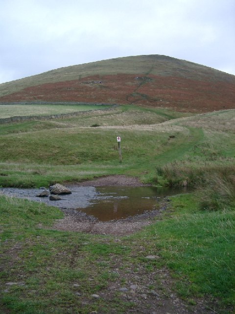
The Tongue is a prominent geographical feature located in Northumberland, England. It is a long, narrow ridge that extends across the landscape, resembling the shape of a tongue, hence its name. Stretching for approximately 10 miles, The Tongue is composed of a combination of downs and moorland, offering a diverse and picturesque terrain.

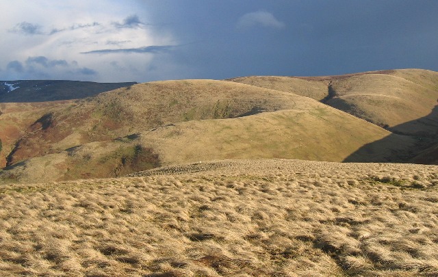
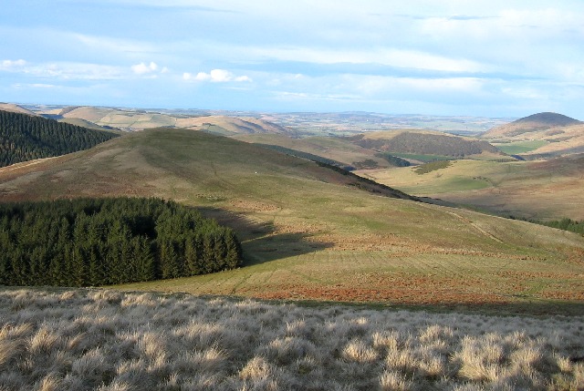
The downs present a rolling landscape with gently sloping hills and panoramic views of the surrounding countryside. The grassy slopes are often covered in vibrant wildflowers during the summer months, adding a splash of color to the scene. The downs are ideal for hikers and nature enthusiasts, providing ample opportunities for outdoor exploration and enjoying the natural beauty of Northumberland.

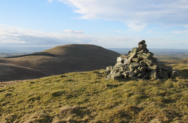
In contrast, the moorland areas of The Tongue offer a more rugged and untamed landscape. Characterized by heather-covered expanses and rocky outcrops, the moorland provides a habitat for various wildlife species, including birds of prey and rare plant species. It is a haven for birdwatchers and wildlife photographers, who can witness the natural wonders of the area.

The Tongue is also intersected by several walking trails, allowing visitors to immerse themselves in the tranquility of the Northumberland countryside. These trails offer a range of difficulty levels, catering to both novice and experienced hikers.

Overall, The Tongue in Northumberland offers a unique blend of downs and moorland, providing a captivating and diverse landscape for outdoor enthusiasts to explore and appreciate the natural beauty of the region.

If you have any feedback on the listing, please let us know in the comments section below.

The Tongue Images

Images are sourced within 2km of 55.535757/-2.22743 or Grid Reference NT8526. Thanks to Geograph Open Source API. All images are credited.

Cairn, Coldsmouth Hill There are three cairns on the summit of Coldsmouth Hill and which are relatively modern additions to the landscape. However, they distract the attention away from the remains of two large Bronze Age burial cairns which have occupied this place for nigh on 3,000 years, and a 1929 excavation of this, the northern most cairn, uncovered cremated bone, a flint knife and a bronze dagger. In the background, from left to right, lie Yeavering Bell, Easter Tor and Wester Tor. For a selection of detailed free to download walking routes in the area visit <span class="nowrap"><a title="www.cheviotwalks.co.uk" rel="nofollow ugc noopener" href="http://www.cheviotwalks.co.uk">Link</a><img style="margin-left:2px;" alt="External link" title="External link - shift click to open in new window" src="https://s1.geograph.org.uk/img/external.png" width="10" height="10"/></span>
Cairn, Coldsmouth Hill
There are three cairns on the summit of Coldsmouth Hill and which are relatively modern additions to the landscape. However, they distract the attention away from the remains of two large Bronze Age burial cairns which have occupied this place for nigh on 3,000 years, and a 1929 excavation of this, the northern most cairn, uncovered cremated bone, a flint knife and a bronze dagger. In the background, from left to right, lie Yeavering Bell, Easter Tor and Wester Tor. For a selection of detailed free to download walking routes in the area visit LinkExternal link
Eccles Cairn Little seems to have changed since I passed this way back in September 2006, see  <a title="https://www.geograph.org.uk/photo/381912)" href="https://www.geograph.org.uk/photo/381912)">Link</a> other than, perhaps, the weather. The view into Scotland remains just as beautiful. For a selection of detailed free to download walking routes in the area visit <span class="nowrap"><a title="www.cheviotwalks.co.uk" rel="nofollow ugc noopener" href="http://www.cheviotwalks.co.uk">Link</a><img style="margin-left:2px;" alt="External link" title="External link - shift click to open in new window" src="https://s1.geograph.org.uk/img/external.png" width="10" height="10"/></span>
Eccles Cairn
Little seems to have changed since I passed this way back in September 2006, see Link other than, perhaps, the weather. The view into Scotland remains just as beautiful. For a selection of detailed free to download walking routes in the area visit LinkExternal link
Marker Post, St. Cuthbert's Way near Eccles Cairn This marker post lies on the route of St. Cuthbert's Way, a 100km (62.5 miles) long distance footpath running from Melrose in the Scottish borders to Holy Island (Lindisfarne) close to the Northumberland coast. The three hills in the background, from left to right, are Easter Tor, Wester Tor and Hare Law. For a selection of detailed free to download walking routes in the area visit <span class="nowrap"><a title="www.cheviotwalks.co.uk" rel="nofollow ugc noopener" href="http://www.cheviotwalks.co.uk">Link</a><img style="margin-left:2px;" alt="External link" title="External link - shift click to open in new window" src="https://s1.geograph.org.uk/img/external.png" width="10" height="10"/></span>
Marker Post, St. Cuthbert's Way near Eccles Cairn
This marker post lies on the route of St. Cuthbert's Way, a 100km (62.5 miles) long distance footpath running from Melrose in the Scottish borders to Holy Island (Lindisfarne) close to the Northumberland coast. The three hills in the background, from left to right, are Easter Tor, Wester Tor and Hare Law. For a selection of detailed free to download walking routes in the area visit LinkExternal link
'Footbridge', St. Cuthbert's Way east of Eccles Cairn This 'footbridge', which is nothing more than a wooden pallet, straddles Tuppie's Sike one of the tributaries of the Elsdon Burn. It lies on the route of St. Cuthbert's Way, a 100km (62.5 miles) long distance footpath running from Melrose in the Scottish borders to Holy Island (Lindisfarne) close to the Northumberland coast. For a selection of detailed free to download walking routes in the area visit <span class="nowrap"><a title="www.cheviotwalks.co.uk" rel="nofollow ugc noopener" href="http://www.cheviotwalks.co.uk">Link</a><img style="margin-left:2px;" alt="External link" title="External link - shift click to open in new window" src="https://s1.geograph.org.uk/img/external.png" width="10" height="10"/></span>
'Footbridge', St. Cuthbert's Way east of Eccles Cairn
This 'footbridge', which is nothing more than a wooden pallet, straddles Tuppie's Sike one of the tributaries of the Elsdon Burn. It lies on the route of St. Cuthbert's Way, a 100km (62.5 miles) long distance footpath running from Melrose in the Scottish borders to Holy Island (Lindisfarne) close to the Northumberland coast. For a selection of detailed free to download walking routes in the area visit LinkExternal link
Cairn, Madam Law When the first edition of the Ordnance Survey Six-inch map of the area was published in 1866 the existence of a 'Tumulus' ("an artificial hillock or mound (as over a grave especially an ancient grave") on the summit of Madam Law was recorded. Whilst this current cairn is a more modern addition to the hill top landscape, there is still evidence of the much larger ancient cairn, which was possibly a Bronze Age burial cairn. The hills in the background, from left to right, are Black Hag, The Curr and White Law. For a selection of detailed free to download walking routes in the area visit <span class="nowrap"><a title="www.cheviotwalks.co.uk" rel="nofollow ugc noopener" href="http://www.cheviotwalks.co.uk">Link</a><img style="margin-left:2px;" alt="External link" title="External link - shift click to open in new window" src="https://s1.geograph.org.uk/img/external.png" width="10" height="10"/></span>
Cairn, Madam Law
When the first edition of the Ordnance Survey Six-inch map of the area was published in 1866 the existence of a 'Tumulus' ("an artificial hillock or mound (as over a grave especially an ancient grave") on the summit of Madam Law was recorded. Whilst this current cairn is a more modern addition to the hill top landscape, there is still evidence of the much larger ancient cairn, which was possibly a Bronze Age burial cairn. The hills in the background, from left to right, are Black Hag, The Curr and White Law. For a selection of detailed free to download walking routes in the area visit LinkExternal link
Public Footpath, Wideopen Head This public footpath links the College Valley, on the English Side of the border, with the Halterburn Valley, on the Scottish side. It is clearly shown on the first edition of the Ordnance Survey Six-inch map of the area. For a selection of detailed free to download walking routes of the area visit <span class="nowrap"><a title="www.cheviotwalks.co.uk" rel="nofollow ugc noopener" href="http://www.cheviotwalks.co.uk">Link</a><img style="margin-left:2px;" alt="External link" title="External link - shift click to open in new window" src="https://s1.geograph.org.uk/img/external.png" width="10" height="10"/></span>
Public Footpath, Wideopen Head
This public footpath links the College Valley, on the English Side of the border, with the Halterburn Valley, on the Scottish side. It is clearly shown on the first edition of the Ordnance Survey Six-inch map of the area. For a selection of detailed free to download walking routes of the area visit LinkExternal link
The Low Pennine Way path near Old Halterburnhead
The Low Pennine Way path near Burnhead
The junction of the High & Low Pennine Way paths near Halfwayhouse
Old Halterburnhead From the "bad-weather route" of the Pennine Way looking NNW. In the background is White Law (<a href="https://www.geograph.org.uk/gridref/NT857261">NT857261</a>), over which the high-level Pennine Way route runs.
Old Halterburnhead
From the "bad-weather route" of the Pennine Way looking NNW. In the background is White Law (NT857261), over which the high-level Pennine Way route runs.
down the Pennine Way to Burnhead Farm Latchley Hill at rear.  one of two routes at the end of the Pennine Way comes through here.
down the Pennine Way to Burnhead Farm
Latchley Hill at rear. one of two routes at the end of the Pennine Way comes through here.
looking up to Sunnyside hill, nr Kirk Yetholm the 1940s map had this hill called something completely different (but I didn't take a note)
looking up to Sunnyside hill, nr Kirk Yetholm
the 1940s map had this hill called something completely different (but I didn't take a note)
Last ford on the Pennine Way Just one more hill, up-and-down, and you've reached Kirk Yetholm and the end of the way.
Last ford on the Pennine Way
Just one more hill, up-and-down, and you've reached Kirk Yetholm and the end of the way.
Scotland England Border on St Cuthberts Way St Cuthberts Way in the Cheviots
Scotland England Border on St Cuthberts Way
St Cuthberts Way in the Cheviots
Trowupburn. Looking SW over this grid square. The main hill on the skyline is "Saughieside" a remote and difficult hill to attain. (by Cheviot standards)
Trowupburn.
Looking SW over this grid square. The main hill on the skyline is "Saughieside" a remote and difficult hill to attain. (by Cheviot standards)
South East from Madam Law The hill immediately in front with its graceful curving ridge is Saughieside, behind to its right is Black Hag. The hill in shadow on the left skyline is Cheviot with a touch of snow high up in the Bizzle.
South East from Madam Law
The hill immediately in front with its graceful curving ridge is Saughieside, behind to its right is Black Hag. The hill in shadow on the left skyline is Cheviot with a touch of snow high up in the Bizzle.
Madam Law's Cairn Looking NNW towards Coldsmouth Hill
Madam Law's Cairn
Looking NNW towards Coldsmouth Hill
High Pasture Looking ENE from the northern slopes of Madam Law. The hill immediately in front (just out of grid square) is Ell's Knowe. Yeavering Bell is the distant hill on the right skyline.
High Pasture
Looking ENE from the northern slopes of Madam Law. The hill immediately in front (just out of grid square) is Ell's Knowe. Yeavering Bell is the distant hill on the right skyline.
Show me another place!

The Tongue is located at Grid Ref: NT8526 (Lat: 55.535757, Lng: -2.22743)

Unitary Authority: Northumberland

Police Authority: Northumbria

What 3 Words

///aced.enacts.snacking. Near Kirknewton, Northumberland

Nearby Locations

The Tongue White Law

Related Wikis

College Valley

The College Valley is an area within the Northumberland National Park in northern England. It is one of five cuttings into the Cheviot Hills. The valley...

Yetholm

Yetholm is the parish that contained the villages of Kirk Yetholm and Town Yetholm in the east of the former county of Roxburghshire, nowadays in the Scottish...

Kirk Yetholm

Kirk Yetholm ('kirk yet-ham') is a village in the Scottish Borders region of Scotland, 8 miles (13 kilometres) southeast of Kelso and less than 1 mile...

Town Yetholm

Town Yetholm ('town yet-ham') is a small village in the Scottish Borders in the valley of the Bowmont Water opposite Kirk Yetholm. The town colours are...

Nearby Amenities

Located within 500m of 55.535757,-2.22743
Information: guidepost
Tourism: information
Lat/Long: 55.535615/-2.2338301
Maddie's Well
Place: locality
Lat/Long: 55.53239/-2.2286144
The Tongue
Place: locality
Lat/Long: 55.5345168/-2.2280764
Tuppie's Grave
Place: locality
Lat/Long: 55.5357012/-2.2324253
The data included in this document is from www.openstreetmap.org. The data is made available under ODbL.

Have you been to The Tongue?

Leave your review of The Tongue below (or comments, questions and feedback).