Peat Fells
Downs, Moorland in Durham
England
Peat Fells

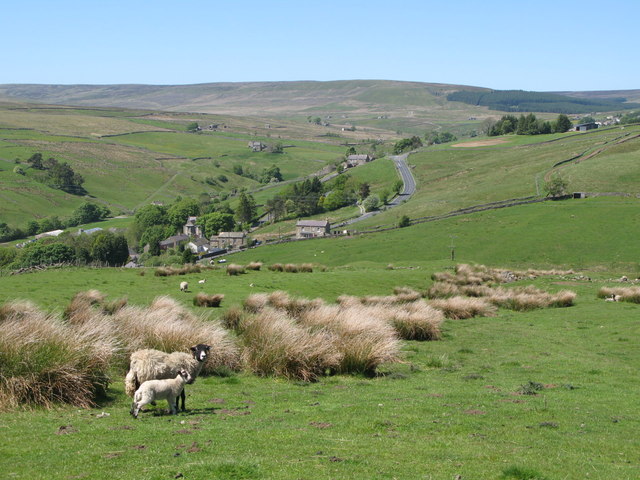
Peat Fells, located in Durham, England, is a picturesque area known for its diverse landscapes, encompassing downs, moorland, and peat bogs. Spanning approximately 500 acres, it is a popular destination for nature enthusiasts and hikers alike.
The downs of Peat Fells offer stunning panoramic views of the surrounding countryside. With rolling hills and open grasslands, this area provides ample opportunities for leisurely walks and picnics. The downs are also home to a variety of flora and fauna, including wildflowers, butterflies, and grazing sheep.
As visitors venture further into Peat Fells, they will encounter its vast moorland. This rugged terrain is characterized by extensive areas of heather, interspersed with patches of gorse and bracken. Moorland birds, such as curlews and lapwings, can often be spotted, adding to the area's natural beauty and biodiversity.
One of the defining features of Peat Fells is its peat bogs, which are a vital component of the landscape. These wetlands are formed by the accumulation of partially decayed plant material, creating a unique habitat for specialized species. Peat Fells' peat bogs are home to rare plants like sphagnum moss and cotton grass, as well as a variety of insect species.
Overall, Peat Fells, with its downs, moorland, and peat bogs, offers visitors a chance to immerse themselves in the natural wonders of Durham. The area's diverse landscapes, coupled with its rich biodiversity, make it an ideal destination for those seeking tranquility and a deeper connection with nature.
If you have any feedback on the listing, please let us know in the comments section below.
Peat Fells Images
Images are sourced within 2km of 54.735696/-2.2561874 or Grid Reference NY8337. Thanks to Geograph Open Source API. All images are credited.


Peat Fells is located at Grid Ref: NY8337 (Lat: 54.735696, Lng: -2.2561874)
Unitary Authority: County Durham
Police Authority: Durham
What 3 Words
///crockery.undulation.roughness. Near Newbiggin, Co. Durham
Nearby Locations
Related Wikis

Far High House Meadows
Far High House Meadows is a Site of Special Scientific Interest in Upper Weardale in west County Durham, England. It consists of three fields, located...
Burnhope Reservoir railway
The Burnhope Reservoir railway was an industrial narrow gauge railway built to serve the construction of Burnhope Reservoir near Weardale. An extensive...

New House, County Durham
New House or Newhouse is a hamlet in the civil parish of Stanhope, in County Durham, England. It lies on the north side of the River Wear, opposite Ireshopeburn...

Wearhead
Wearhead is a village in the civil parish of Stanhope, in County Durham, England. It is situated at the top of Weardale between Cowshill and Ireshopeburn...

Wearhead railway station
Wearhead railway station served the village of Wearhead, County Durham, England, from 1895 to 1961 on the Weardale Railway. == History == The station opened...

Ireshopeburn
Ireshopeburn ( EYE-sup-burn ) is a village in the civil parish of Stanhope, in County Durham, England. It is situated on the south side of Weardale, between...

Cowshill
Cowshill is a village in the civil parish of Stanhope, in County Durham, England. It is situated at the top of Weardale, between Lanehead and Wearhead...
Copthill
Copthill is a village in the civil parish of Stanhope, in County Durham, England. It is situated on the north side of Weardale, between Cowshill and Cornriggs...
Nearby Amenities
Located within 500m of 54.735696,-2.2561874Have you been to Peat Fells?
Leave your review of Peat Fells below (or comments, questions and feedback).