Foggie Brae
Downs, Moorland in Kincardineshire
Scotland
Foggie Brae
Foggie Brae is a picturesque area located in Kincardineshire, a county in northeastern Scotland. Nestled amidst the beautiful Downs and Moorland, this region offers stunning natural landscapes and a tranquil atmosphere.
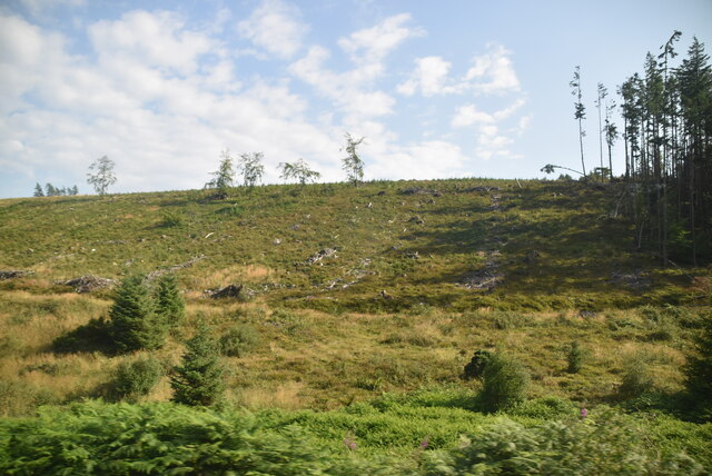
The area is characterized by gently rolling hills covered in vibrant green grass, scattered with patches of heather and wildflowers. The Downs, with their wide-open spaces and breathtaking views, create a sense of immense serenity and isolation. The Moorland, on the other hand, adds a touch of ruggedness to the landscape, with its vast stretches of heath and peat bogs.
Foggie Brae is renowned for its diverse wildlife, making it a haven for nature enthusiasts. Visitors can spot a variety of bird species, including golden eagles, peregrine falcons, and red grouse, soaring through the skies. The area is also home to several mammals, such as red deer, mountain hares, and Scottish wildcats, adding to the rich biodiversity.
Hiking and walking trails are plentiful in Foggie Brae, allowing visitors to explore the area's natural wonders at their own pace. The paths wind through the hills and moors, offering breathtaking views of the surrounding countryside. The changing seasons bring a kaleidoscope of colors to the landscape, with vibrant autumn foliage and blooming wildflowers in the spring and summer.
Overall, Foggie Brae in Kincardineshire is a true gem for those seeking a peaceful retreat in the midst of Scotland's natural beauty. With its picturesque Downs and Moorland, diverse wildlife, and stunning hiking trails, it offers a unique and unforgettable experience for nature lovers and adventurers alike.
If you have any feedback on the listing, please let us know in the comments section below.
Foggie Brae Images
Images are sourced within 2km of 56.950596/-2.2877012 or Grid Reference NO8284. Thanks to Geograph Open Source API. All images are credited.


Foggie Brae is located at Grid Ref: NO8284 (Lat: 56.950596, Lng: -2.2877012)
Unitary Authority: Aberdeenshire
Police Authority: North East
What 3 Words
///verge.polishing.machinery. Near Stonehaven, Aberdeenshire
Nearby Locations
Related Wikis

Tewel
Tewel is a hamlet located approximately two miles west of Stonehaven, Kincardineshire on the Auchenblae Road in Northeast Scotland. It consists of: Tewel...
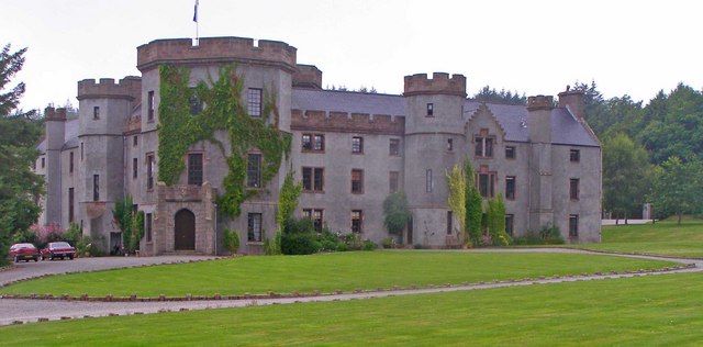
Fetteresso Castle
Fetteresso Castle is a 14th-century tower house, rebuilt in 1761 as a Scottish Gothic style Palladian manor, with clear evidence of prehistoric use of...
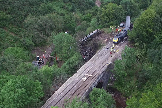
Stonehaven derailment
The Stonehaven derailment was a fatal railway accident that occurred at 09:38 BST on 12 August 2020, when a passenger train returning to Aberdeen hit a...

Castle of Fiddes
The Castle of Fiddes is a 16th-century tower house in Aberdeenshire, Scotland, located around 6 kilometres (3.7 mi) south-west of Stonehaven. It is dated...
Nearby Amenities
Located within 500m of 56.950596,-2.2877012Have you been to Foggie Brae?
Leave your review of Foggie Brae below (or comments, questions and feedback).