Glass Moss

Downs, Moorland in Yorkshire Craven

England

Glass Moss

Ribble Way & Pennine Way leading south towards Horton in Ribblesddale
Ribble Way & Pennine Way leading south towards Horton in Ribblesddale Credit: Colin Park

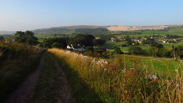
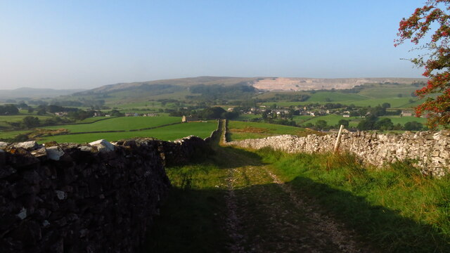
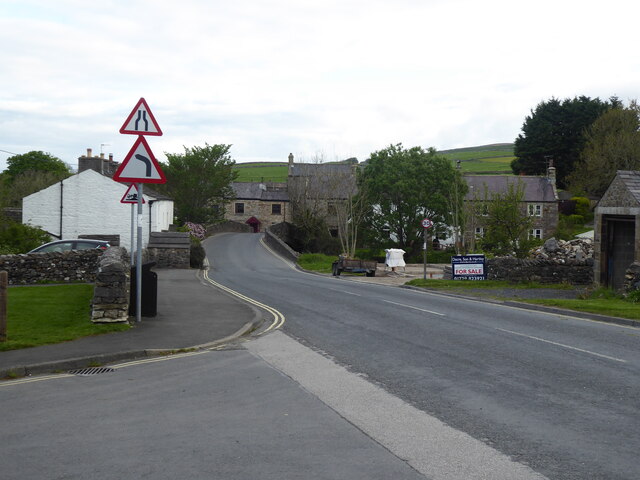
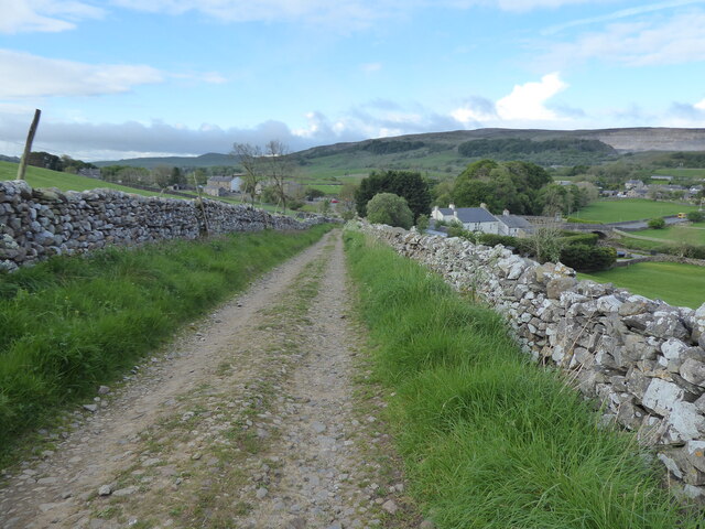
Glass Moss is a picturesque village located in the county of Yorkshire, England. Situated amidst the stunning landscapes of the Yorkshire Downs and Moorland, this village offers residents and visitors alike a tranquil and idyllic setting to escape the hustle and bustle of city life.

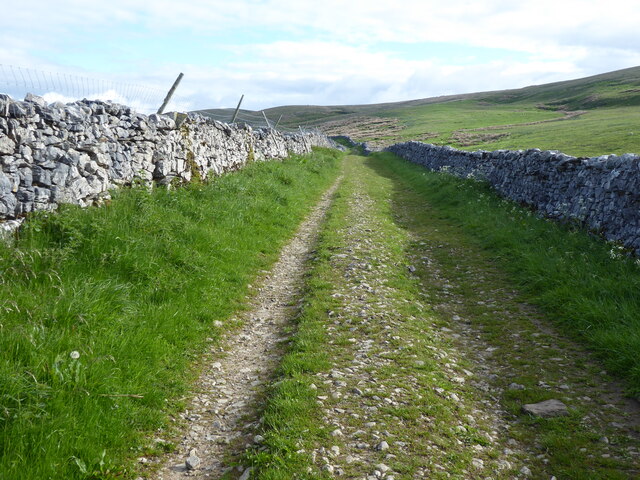
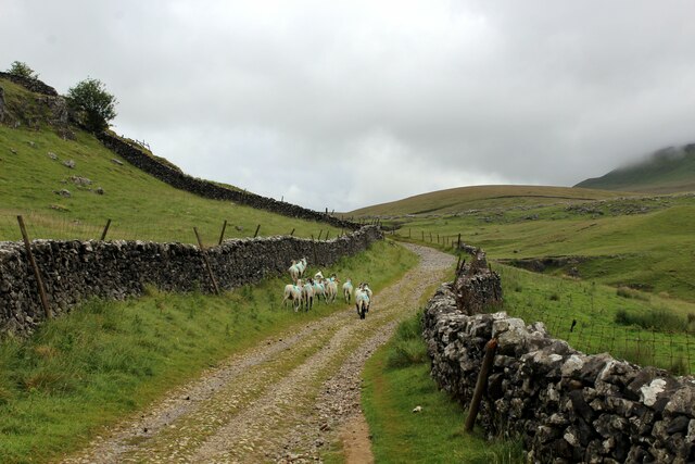
Surrounded by rolling hills and vast expanses of open moorland, Glass Moss is a haven for nature lovers and outdoor enthusiasts. The village is known for its breathtaking scenery, with panoramic views of the surrounding countryside, including the iconic heather-covered moors that Yorkshire is famous for.

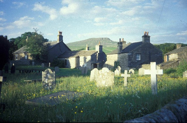
The village itself is small and charming, with a tight-knit community that takes pride in its local heritage. Traditional stone cottages line the narrow streets, and the village church, St. Mary's, stands proudly as a testament to the area's long history. The village also boasts a cozy pub, the Glass Moss Inn, where locals and visitors gather to enjoy hearty meals and ales.

For those seeking outdoor adventures, Glass Moss offers a myriad of opportunities. Hiking and cycling trails wind through the moorland, allowing visitors to explore the untouched beauty of the countryside. Birdwatchers will be delighted by the diverse species that can be spotted in the area, including the elusive red grouse and the majestic golden eagle.

Glass Moss truly exemplifies the charm and natural beauty of the Yorkshire countryside. Whether it's taking in the breathtaking views, immersing oneself in the local history, or simply enjoying the tranquility of rural life, this village offers a unique and unforgettable experience for all who visit.

If you have any feedback on the listing, please let us know in the comments section below.

Glass Moss Images

Images are sourced within 2km of 54.155855/-2.2681014 or Grid Reference SD8273. Thanks to Geograph Open Source API. All images are credited.

Ribble Way & Pennine Way leading south towards Horton in Ribblesddale
Footpath leading southwest from Sell Gill Holes near Horton in Ribblesdale
Hull Pot, Pen-y-Ghent
Hull Pot Beck, Pen-y-Ghent
Hull Pot, Pen-y-Ghent
Path crossing Hull Pot Beck, Pen-y-Ghent The stepping stones are submerged!
Path crossing Hull Pot Beck, Pen-y-Ghent
The stepping stones are submerged!
The Pennine Way along the B6479 in Horton in Ribblesdale
The Pennine Way near Horton in Ribblesdale
The Pennine Way near Harber Scar
The Pennine Way near Whitber Pasture
The Pennine Way near Sell Gill Holes
Approaching Ruined Stone Barn on Horton Scar Road Adopted by the Pennine Way National Trail
Approaching Ruined Stone Barn on Horton Scar Road
Adopted by the Pennine Way National Trail
View towards Pen-y-Ghent from Horton Bridge
Ascending Horton Scar Lane Gradual ascent on a walled track, adopted by the Pennine Way National Trail
Ascending Horton Scar Lane
Gradual ascent on a walled track, adopted by the Pennine Way National Trail
Sheep on Horton Scar Lane Walled track adopted by the Pennine Way National Trail, ascending towards Pen-y-Ghent and moorland surroundings.
Sheep on Horton Scar Lane
Walled track adopted by the Pennine Way National Trail, ascending towards Pen-y-Ghent and moorland surroundings.
On Whitber Hill Section of the Three Peaks challenge walk - a testing hike of 25 miles that is to be completed within 10 hours.
Once it was a slog through peat creating wide swathes of disturbed sloppy moorland - but now the authorities that be have created hard paths over much of the route, making it much easier to succeed while protecting the environment
On Whitber Hill
Section of the Three Peaks challenge walk - a testing hike of 25 miles that is to be completed within 10 hours. Once it was a slog through peat creating wide swathes of disturbed sloppy moorland - but now the authorities that be have created hard paths over much of the route, making it much easier to succeed while protecting the environment
Show me another place!

Glass Moss is located at Grid Ref: SD8273 (Lat: 54.155855, Lng: -2.2681014)

Division: West Riding

Administrative County: North Yorkshire

District: Craven

Police Authority: North Yorkshire

What 3 Words

///strut.towel.kilowatt. Near Settle, North Yorkshire

Related Wikis

Pen-y-ghent

Pen-y-ghent or Penyghent is a fell in the Yorkshire Dales, England. It is the lowest of Yorkshire's Three Peaks at 2,277 feet (694 m); the other two being...

Brackenbottom

Brackenbottom is a village in Ribblesdale, North Yorkshire, England. == External links == Media related to Brackenbottom at Wikimedia Commons

Horton in Ribblesdale

Horton in Ribblesdale is a small village and civil parish in the Craven district of North Yorkshire, England. It is situated in Ribblesdale on the Settle...
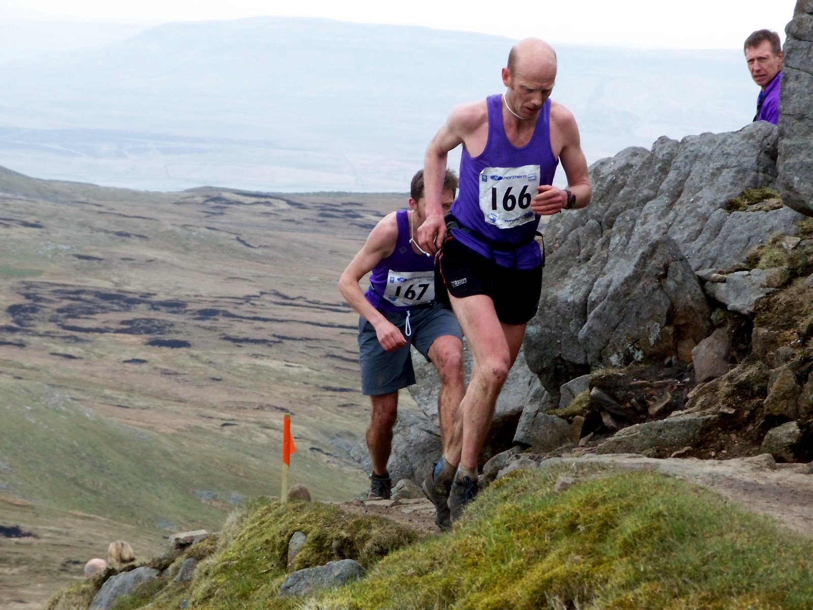
Three Peaks Race

The Three Peaks Race is a fell race held annually on the last weekend in April, starting and finishing in Horton in Ribblesdale. The course traverses the...

Nearby Amenities

Located within 500m of 54.155855,-2.2681014
Penyghent Pot
Natural: cave_entrance
Source: survey
Lat/Long: 54.1554072/-2.2634424
Glass Moss
Natural: wetland
Lat/Long: 54.1553374/-2.2677037
Natural: sinkhole
Source: Bing
Lat/Long: 54.1596013/-2.2696847
Natural: sinkhole
Source: Bing
Lat/Long: 54.1532127/-2.2695744
Natural: sinkhole
Source: Bing
Lat/Long: 54.1538662/-2.2707171
Natural: sinkhole
Source: Bing
Lat/Long: 54.1536681/-2.2668874
Natural: sinkhole
Source: Bing
Lat/Long: 54.1538473/-2.2667909
Natural: sinkhole
Source: Bing
Lat/Long: 54.1537082/-2.2693738
Natural: sinkhole
Source: Bing
Lat/Long: 54.1540107/-2.2666675
Natural: sinkhole
Source: Bing
Lat/Long: 54.1537751/-2.2668874
Natural: sinkhole
Source: Bing
Lat/Long: 54.1558661/-2.2701463
Natural: sinkhole
Source: Bing
Lat/Long: 54.1565544/-2.2698778
Natural: sinkhole
Source: Bing
Lat/Long: 54.1581941/-2.2668968
Natural: sinkhole
Source: Bing
Lat/Long: 54.1571135/-2.2710902
Natural: sinkhole
Source: Bing
Lat/Long: 54.1567114/-2.2699315
Natural: sinkhole
Source: Bing
Lat/Long: 54.1540317/-2.2708276
Natural: sinkhole
Source: Bing
Lat/Long: 54.1573711/-2.2709292
Natural: sinkhole
Source: Bing
Lat/Long: 54.1594502/-2.2685276
Natural: sinkhole
Source: Bing
Lat/Long: 54.1578046/-2.2704572
Natural: sinkhole
Source: Bing
Lat/Long: 54.1529646/-2.2682392
Natural: sinkhole
Source: Bing
Lat/Long: 54.1530304/-2.2703469
Natural: sinkhole
Source: Bing
Lat/Long: 54.1574151/-2.2699422
Natural: sinkhole
Source: Bing
Lat/Long: 54.1563345/-2.2712296
Natural: sinkhole
Source: Bing
Lat/Long: 54.1560829/-2.2711173
Natural: sinkhole
Source: Bing
Lat/Long: 54.1566612/-2.2711975
Natural: sinkhole
Source: Bing
Lat/Long: 54.1573331/-2.2699422
Natural: sinkhole
Source: Bing
Lat/Long: 54.1561459/-2.271128
Natural: sinkhole
Source: Bing
Lat/Long: 54.1557406/-2.2710851
Natural: sinkhole
Source: Bing
Lat/Long: 54.1528859/-2.2681963
Natural: sinkhole
Source: Bing
Lat/Long: 54.1552913/-2.2706184
Natural: sinkhole
Source: Bing
Lat/Long: 54.1580056/-2.2689229
Natural: sinkhole
Source: Bing
Lat/Long: 54.1586778/-2.2686563
Natural: sinkhole
Source: Bing
Lat/Long: 54.1574779/-2.2708756
Natural: sinkhole
Source: Bing
Lat/Long: 54.1570381/-2.2711009
Natural: sinkhole
Source: Bing
Lat/Long: 54.157597/-2.2706825
Natural: sinkhole
Source: Bing
Lat/Long: 54.1560483/-2.2699854
Natural: sinkhole
Source: Bing
Lat/Long: 54.156435/-2.2698778
Natural: sinkhole
Source: Bing
Lat/Long: 54.1540223/-2.2687253
Natural: sinkhole
Source: Bing
Lat/Long: 54.1562591/-2.2712726
Natural: sinkhole
Source: Bing
Lat/Long: 54.1602546/-2.2689766
Natural: sinkhole
Source: Bing
Lat/Long: 54.1581183/-2.2687517
Natural: sinkhole
Source: Bing
Lat/Long: 54.1582425/-2.2687251
Natural: sinkhole
Source: Bing
Lat/Long: 54.1581941/-2.2665964
Natural: sinkhole
Source: Bing
Lat/Long: 54.1589417/-2.268195
Natural: sinkhole
Source: Bing
Lat/Long: 54.1542398/-2.2663724
Natural: sinkhole
Source: Bing
Lat/Long: 54.1524839/-2.2684431
Natural: sinkhole
Source: Bing
Lat/Long: 54.1541709/-2.2664475
Natural: sinkhole
Source: Bing
Lat/Long: 54.1539855/-2.2684002
Natural: sinkhole
Source: Bing
Lat/Long: 54.1537499/-2.2705186
Natural: sinkhole
Source: Bing
Lat/Long: 54.155989/-2.2682164
Natural: sinkhole
Source: Bing
Lat/Long: 54.1559101/-2.2711226
Natural: sinkhole
Source: Bing
Lat/Long: 54.1530429/-2.2682661
Natural: sinkhole
Source: Bing
Lat/Long: 54.1531246/-2.2683036
Natural: sinkhole
Source: Bing
Lat/Long: 54.1575847/-2.2688275
Natural: sinkhole
Source: Bing
Lat/Long: 54.1531311/-2.270245
Natural: sinkhole
Source: Bing
Lat/Long: 54.1561898/-2.2699049
Natural: sinkhole
Source: Bing
Lat/Long: 54.1577729/-2.2688382
Natural: sinkhole
Note: could this be lead mining? appears to be spoil to N
Source: Bing
Lat/Long: 54.1579723/-2.2694544
Natural: sinkhole
Source: Bing
Lat/Long: 54.1530429/-2.2696227
Natural: sinkhole
Source: Bing
Lat/Long: 54.1560106/-2.2711441
Natural: sinkhole
Source: Bing
Lat/Long: 54.1567363/-2.2711545
Natural: sinkhole
Source: Bing
Lat/Long: 54.1565795/-2.2712189
Natural: sinkhole
Source: Bing
Lat/Long: 54.156812/-2.2711224
Natural: sinkhole
Source: Bing
Lat/Long: 54.1543459/-2.2708383
Natural: sinkhole
Source: Bing
Lat/Long: 54.1556213/-2.2711387
Natural: sinkhole
Note: could this be lead mining? appears to be spoil to N
Source: Bing
Lat/Long: 54.1579849/-2.2697602
Natural: sinkhole
Note: could this be lead mining? appears to be spoil to N
Source: Bing
Lat/Long: 54.1579849/-2.269669
Natural: sinkhole
Source: Bing
Lat/Long: 54.1537677/-2.2696903
Natural: sinkhole
Note: could this be lead mining? appears to be spoil to N
Source: Bing
Lat/Long: 54.1579645/-2.2693659
Natural: sinkhole
Note: could this be lead mining? appears to be spoil to N
Source: Bing
Lat/Long: 54.157977/-2.2695161
Natural: sinkhole
Source: Bing
Lat/Long: 54.1556745/-2.2711119
Natural: sinkhole
Source: Bing
Lat/Long: 54.1555773/-2.2711548
Natural: sinkhole
Source: Bing
Lat/Long: 54.1538684/-2.2694757
Natural: sinkhole
Source: Bing
Lat/Long: 54.1527445/-2.2672737
Natural: sinkhole
Source: Bing
Lat/Long: 54.1541949/-2.2708705
Natural: sinkhole
Source: Bing
Lat/Long: 54.153683/-2.2691646
Natural: sinkhole
Source: Bing
Lat/Long: 54.1577418/-2.2705323
Natural: sinkhole
Source: Bing
Lat/Long: 54.1576661/-2.2706181
Natural: sinkhole
Source: Bing
Lat/Long: 54.1532998/-2.270098
Natural: sinkhole
Source: Bing
Lat/Long: 54.1529237/-2.2689146
Natural: sinkhole
Note: could this be lead mining? appears to be spoil to N
Source: Bing
Lat/Long: 54.157977/-2.2695993
Natural: sinkhole
Source: Bing
Lat/Long: 54.1564099/-2.2712082
Natural: sinkhole
Source: Bing
Lat/Long: 54.1547008/-2.2697011
Natural: sinkhole
Source: Bing
Lat/Long: 54.1575593/-2.2699636
Natural: sinkhole
Source: Bing
Lat/Long: 54.157214/-2.2699422
Natural: sinkhole
Source: Bing
Lat/Long: 54.1568874/-2.2711224
Natural: sinkhole
Source: Bing
Lat/Long: 54.1562055/-2.2711173
Natural: sinkhole
Source: Bing
Lat/Long: 54.1572266/-2.2710687
Natural: sinkhole
Source: Bing
Lat/Long: 54.1561711/-2.2712296
Natural: sinkhole
Source: Bing
Lat/Long: 54.1539353/-2.2667479
Building: ruins
Fixme: location approximate
Historic: lime_kiln
Man Made: kiln
Mineral: limestone
Product: quicklime
Source: OS sheet 97,1851
Lat/Long: 54.1548053/-2.2724871
Natural: sinkhole
Lat/Long: 54.1564979/-2.2692559
Natural: sinkhole
Lat/Long: 54.1565106/-2.2695809
Natural: sinkhole
Lat/Long: 54.156187/-2.2702417
Natural: sinkhole
Lat/Long: 54.1552164/-2.2701875
Natural: sinkhole
Lat/Long: 54.1551276/-2.2698517
Natural: sinkhole
Lat/Long: 54.1543409/-2.269765
Natural: sinkhole
Lat/Long: 54.1546328/-2.268818
Natural: sinkhole
Lat/Long: 54.1547053/-2.2688447
Natural: sinkhole
Lat/Long: 54.1547856/-2.2688146
Natural: sinkhole
Lat/Long: 54.1549167/-2.2687377
Natural: sinkhole
Lat/Long: 54.154905/-2.2685471
Natural: sinkhole
Lat/Long: 54.1540991/-2.2686472
Natural: sinkhole
Lat/Long: 54.154065/-2.2682173
Natural: sinkhole
Lat/Long: 54.1539834/-2.2682057
Natural: sinkhole
Lat/Long: 54.1537498/-2.2682676
Natural: sinkhole
Lat/Long: 54.1593555/-2.2636186
Natural: sinkhole
Lat/Long: 54.1514624/-2.2664838
Natural: sinkhole
Lat/Long: 54.1516175/-2.2666223
Natural: sinkhole
Lat/Long: 54.1517867/-2.2669172
Natural: sinkhole
Lat/Long: 54.1519805/-2.2669352
Natural: sinkhole
Lat/Long: 54.1518458/-2.268575
Natural: sinkhole
Lat/Long: 54.1515526/-2.2682762
Natural: sinkhole
Lat/Long: 54.1518033/-2.2677594
Natural: sinkhole
Lat/Long: 54.1519404/-2.2677029
Natural: sinkhole
Lat/Long: 54.1528216/-2.2670843
Natural: sinkhole
Lat/Long: 54.1525315/-2.2667628
Natural: sinkhole
Lat/Long: 54.1523686/-2.2668757
Natural: sinkhole
Lat/Long: 54.1524704/-2.2646162
Natural: sinkhole
Lat/Long: 54.1524985/-2.264493
Natural: sinkhole
Lat/Long: 54.1525815/-2.2645305
Natural: sinkhole
Lat/Long: 54.152601/-2.2646222
Natural: sinkhole
Lat/Long: 54.1526449/-2.2646514
Natural: sinkhole
Lat/Long: 54.1527182/-2.2646014
Natural: sinkhole
Lat/Long: 54.1528426/-2.2646097
Natural: sinkhole
Lat/Long: 54.1530721/-2.2647056
Natural: sinkhole
Lat/Long: 54.1530721/-2.2648848
Natural: sinkhole
Lat/Long: 54.1534163/-2.2646014
Natural: sinkhole
Lat/Long: 54.1534651/-2.2646347
Natural: sinkhole
Lat/Long: 54.153553/-2.2646139
Natural: sinkhole
Lat/Long: 54.1536531/-2.2646431
Natural: sinkhole
Lat/Long: 54.1538557/-2.2645806
Natural: sinkhole
Lat/Long: 54.1535353/-2.2643778
Natural: sinkhole
Lat/Long: 54.1534567/-2.2642939
Natural: sinkhole
Lat/Long: 54.1532177/-2.2640199
Natural: sinkhole
Lat/Long: 54.1532832/-2.2635837
Natural: sinkhole
Lat/Long: 54.1530768/-2.2631643
Natural: sinkhole
Lat/Long: 54.1529851/-2.2631643
Natural: sinkhole
Lat/Long: 54.1529229/-2.263237
Natural: sinkhole
Lat/Long: 54.1528083/-2.263265
Natural: sinkhole
Lat/Long: 54.1525823/-2.2634439
Natural: sinkhole
Lat/Long: 54.1527231/-2.2640814
Natural: sinkhole
Lat/Long: 54.1530015/-2.2640087
The data included in this document is from www.openstreetmap.org. The data is made available under ODbL.

Have you been to Glass Moss?

Leave your review of Glass Moss below (or comments, questions and feedback).