Garsdale Common

Downs, Moorland in Yorkshire South Lakeland

England

Garsdale Common

The Staycation Express at Garsdale A Locomotive Services Limited service on the Settle-Carlisle Railway.
The Staycation Express at Garsdale Credit: Andrew Abbott

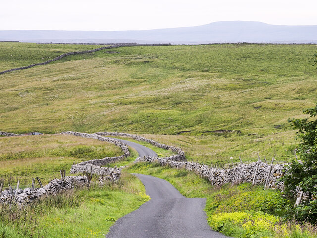
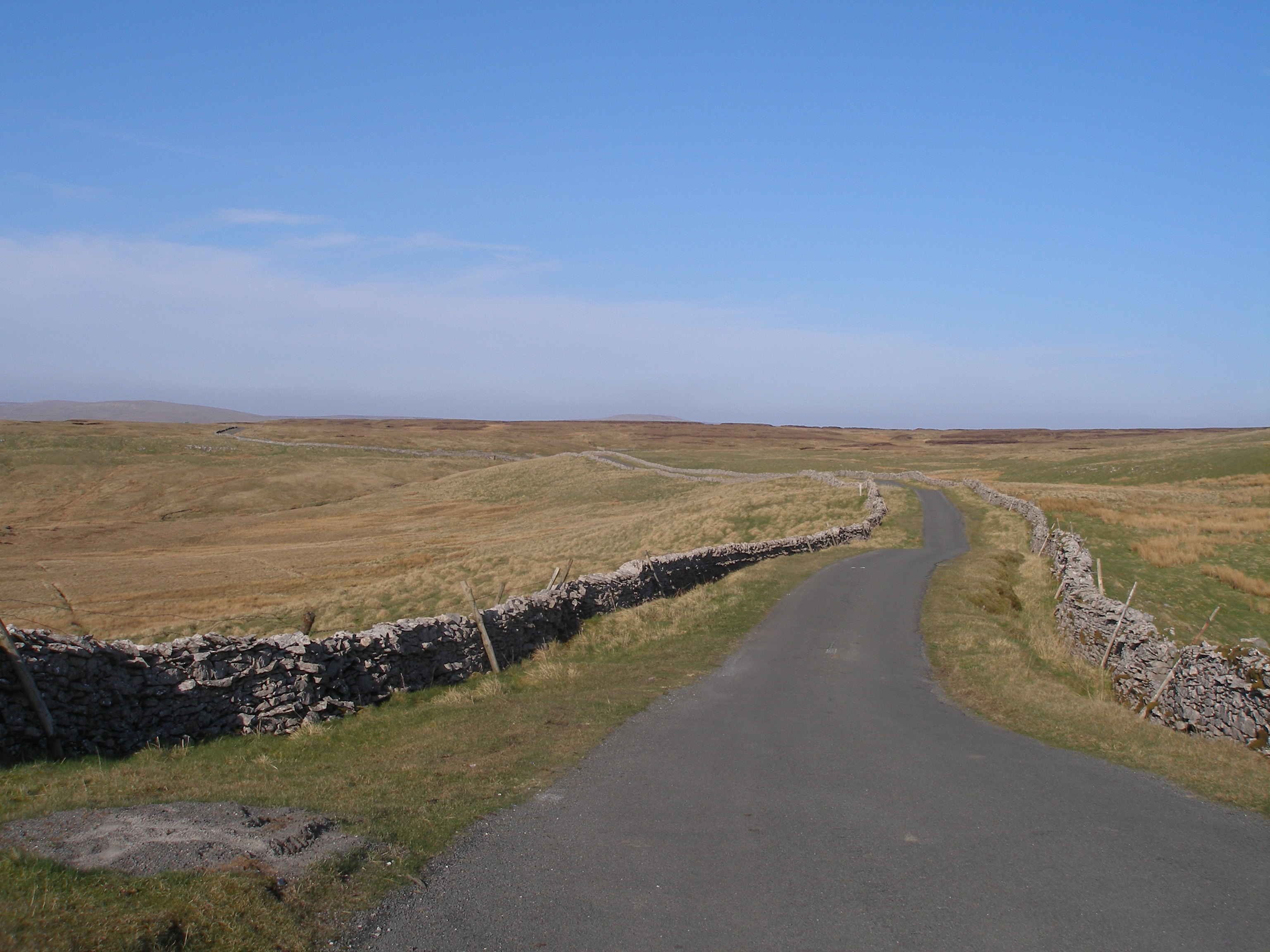
Garsdale Common is a picturesque area located in the Yorkshire Dales National Park, in the county of Yorkshire, England. Spread across the rolling hills, downs, and moorland, it covers an expansive area of approximately 4,000 acres. The common is situated in the upper valley of Garsdale, which is surrounded by the beautiful fells and peaks of the Pennines.

This area is known for its stunning natural beauty, with its vast open spaces, heather-covered moorland, and panoramic views of the surrounding countryside. Garsdale Common is home to a diverse range of flora and fauna, including rare bird species such as curlews, lapwings, and red grouse. The rocky outcrops and peat bogs provide a unique habitat for a variety of plant life, including cotton grass, heather, and bilberry.

The common is popular with walkers, hikers, and nature enthusiasts, who come to explore the numerous footpaths and trails that crisscross the area. These trails offer breathtaking views of the surrounding valleys and mountains, making it a haven for photographers and artists alike.

In addition to its natural beauty, Garsdale Common also has a rich cultural history. The area is dotted with ancient archaeological sites, including burial mounds and stone circles, which provide insight into the lives of the people who lived here thousands of years ago.

Overall, Garsdale Common offers a tranquil and idyllic escape for those seeking to immerse themselves in the stunning landscapes and rich history of Yorkshire's countryside.

If you have any feedback on the listing, please let us know in the comments section below.

Garsdale Common Images

Images are sourced within 2km of 54.308465/-2.3309231 or Grid Reference SD7890. Thanks to Geograph Open Source API. All images are credited.

The Staycation Express at Garsdale A Locomotive Services Limited service on the Settle-Carlisle Railway.
The Staycation Express at Garsdale
A Locomotive Services Limited service on the Settle-Carlisle Railway.
The 12.08 to Leeds at Garsdale Train 158901. Headcode 2H89. The 1058 Carlisle to Leeds service arrives at Garsdale.
The 12.08 to Leeds at Garsdale
Train 158901. Headcode 2H89. The 1058 Carlisle to Leeds service arrives at Garsdale.
Railhead Treatment Train in action south through Garsdale Station Two FEA wagons with RHTT modules between two Class 68 locomotives, 68005 at the head
Railhead Treatment Train in action south through Garsdale Station
Two FEA wagons with RHTT modules between two Class 68 locomotives, 68005 at the head
Class 66/7 diesel locomotive heads train through Garsdale Station Taking stone from Arcow Quarry to Mossend
Class 66/7 diesel locomotive heads train through Garsdale Station
Taking stone from Arcow Quarry to Mossend
Staycation Express southbound through Garsdale Station passing the refurbished signal box The charter train uses HST power cars (43058 and 43059) previously in service with East Midlands Trains and coaches from Great Western Railway.
Staycation Express southbound through Garsdale Station passing the refurbished signal box
The charter train uses HST power cars (43058 and 43059) previously in service with East Midlands Trains and coaches from Great Western Railway.
Sunset at Garsdale Head viewed from Railway Cottages
Hard Ing Barn
Hard Ing Barn
Low Scale
Low Scale
Minor road descending towards Garsdale The winding, undulating road crosses high moorland north-west of Widdale Fell. As it rises from Garsdale it also acts for over four kilometres as the route of the long distance trail, 'Pennine Bridleway'.
Minor road descending towards Garsdale
The winding, undulating road crosses high moorland north-west of Widdale Fell. As it rises from Garsdale it also acts for over four kilometres as the route of the long distance trail, 'Pennine Bridleway'.
Royal Scotsman clagging through Garsdale Station Passing the station flower bed which has the statue to Ruswarp
Royal Scotsman clagging through Garsdale Station
Passing the station flower bed which has the statue to Ruswarp
Swimming in the pool below Clough Force
Benchmark at base of wall (at wall junction) on east side of Coal Road Ordnance Survey pivot benchmark shown as levelled at 1058.3 feet above Liverpool Datum on 1888-1913 6" Map
Benchmark at base of wall (at wall junction) on east side of Coal Road
Ordnance Survey pivot benchmark shown as levelled at 1058.3 feet above Liverpool Datum on 1888-1913 6" Map
Coal Road approaching A684 junction There is an Ordnance Survey benchmark <a href="https://www.geograph.org.uk/photo/7254493">SD7891 : Benchmark at base of wall (at wall junction) on east side of Coal Road</a> on a stone at the base of the wall on the left hand side of the wooden post
Coal Road approaching A684 junction
There is an Ordnance Survey benchmark SD7891 : Benchmark at base of wall (at wall junction) on east side of Coal Road on a stone at the base of the wall on the left hand side of the wooden post
Coal Road heading south past plantation at Edwin's Fell The Ordnance Survey 1888-1913 6" Map shows a benchmark levelled at 1222.5 feet above Liverpool Datum on the left hand side of the road here
Coal Road heading south past plantation at Edwin's Fell
The Ordnance Survey 1888-1913 6" Map shows a benchmark levelled at 1222.5 feet above Liverpool Datum on the left hand side of the road here
Evening view towards Swarth Fell and Wild Boar Fell from Coal Road The Ordnance Survey 1888-1913 6" Map shows a benchmark levelled at 1275.5 feet above Liverpool Datum on the left hand side of the road here
Evening view towards Swarth Fell and Wild Boar Fell from Coal Road
The Ordnance Survey 1888-1913 6" Map shows a benchmark levelled at 1275.5 feet above Liverpool Datum on the left hand side of the road here
Northwest parapet of Low Scale Bridge which carries A684 over Clough River Ordnance Survey records indicate that a benchmark was levelled at 950.190 feet above Liverpool Datum during the 1845 Kirkby Kendal to Thirsk 1GL Survey on a parapet of a bridge at this location. The surveyor's description was 'No. 57. Mark on North battlement of Kundsman or Low Scale Bridge ; 2.73 ft. below top of battlement'
Northwest parapet of Low Scale Bridge which carries A684 over Clough River
Ordnance Survey records indicate that a benchmark was levelled at 950.190 feet above Liverpool Datum during the 1845 Kirkby Kendal to Thirsk 1GL Survey on a parapet of a bridge at this location. The surveyor's description was 'No. 57. Mark on North battlement of Kundsman or Low Scale Bridge ; 2.73 ft. below top of battlement'
NW parapet of Low Scale (Knudman) Bridge for A684 over Clough River
Clough River in Garsdale
Show me another place!

Garsdale Common is located at Grid Ref: SD7890 (Lat: 54.308465, Lng: -2.3309231)

Division: West Riding

Administrative County: Cumbria

District: South Lakeland

Police Authority: Cumbria

What 3 Words

///legs.unites.swatting. Near Sedbergh, Cumbria

Related Wikis

Coal Road

The Coal Road (also known as the Galloway Gate Road) is an unclassified highway which connects the railway stations at Garsdale and Dent in Cumbria, England...

Garsdale railway station

Garsdale is a railway station in Cumbria, England (historically in the West Riding of Yorkshire), on the Settle and Carlisle Line, which runs between Carlisle...

Garsdale Head

Garsdale Head is a hamlet mainly within the South Lakeland district of Cumbria, England. Historically part of the West Riding of Yorkshire, the hamlet...

Dandry Mire Viaduct

Dandry Mire Viaduct, (or Dandrymire Viaduct), is a railway viaduct on the Settle & Carlisle line in Cumbria, England. It is just north of Garsdale station...

Have you been to Garsdale Common?

Leave your review of Garsdale Common below (or comments, questions and feedback).