Gibson Pasture

Downs, Moorland in Yorkshire Richmondshire

England

Gibson Pasture

View along Grisedale from moorland above Riggs
View along Grisedale from moorland above Riggs Credit: Luke Shaw

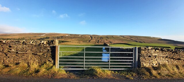
Gibson Pasture is a picturesque area located in Yorkshire, England. Nestled amidst the stunning landscape of the Yorkshire Downs and Moorland, this region is renowned for its natural beauty and rich biodiversity. Spanning over a vast expanse of land, Gibson Pasture offers visitors a unique experience of the English countryside.

The rolling hills and lush green meadows of the Yorkshire Downs create a breathtaking backdrop for those exploring Gibson Pasture. The area is characterized by its extensive network of walking trails, providing ample opportunities for outdoor enthusiasts to immerse themselves in the stunning surroundings. Visitors can hike through the moorland, taking in the panoramic views and encountering an array of flora and fauna along the way.

The diverse wildlife of Gibson Pasture is a major draw for nature lovers. The area is home to numerous species of birds, such as curlews, lapwings, and grouse, making it a haven for birdwatchers. Additionally, the moorland provides a habitat for various mammals, including hares, badgers, and deer.

Gibson Pasture also boasts a rich cultural heritage. The area is dotted with ancient archaeological sites, such as burial mounds and stone circles, providing a glimpse into the region's past. These historical landmarks add a sense of intrigue and wonder to the already captivating landscape.

Overall, Gibson Pasture offers a serene and idyllic escape from the hustle and bustle of everyday life. Whether it's exploring the moorland, observing the diverse wildlife, or unraveling the mysteries of the past, this charming area in Yorkshire is a must-visit destination for nature enthusiasts and history buffs alike.

If you have any feedback on the listing, please let us know in the comments section below.

Gibson Pasture Images

Images are sourced within 2km of 54.34035/-2.3317484 or Grid Reference SD7893. Thanks to Geograph Open Source API. All images are credited.

View along Grisedale from moorland above Riggs
Barn in field on east side of B6259 at junction with footpath to How Beck Bridge The barn is now losing its roof: compare with 2013 photo <a href="https://www.geograph.org.uk/photo/3771178">SD7895 : Barn beside B6259 opposite White Birch Cottage</a>
Barn in field on east side of B6259 at junction with footpath to How Beck Bridge
The barn is now losing its roof: compare with 2013 photo SD7895 : Barn beside B6259 opposite White Birch Cottage
Track heading down towards Shaw Paddock Old Maps from 1853 to 1957 show an Ordnance Survey benchmark levelled at 1142.5 feet above Liverpool Datum at the left hand side of the track here.
Track heading down towards Shaw Paddock
Old Maps from 1853 to 1957 show an Ordnance Survey benchmark levelled at 1142.5 feet above Liverpool Datum at the left hand side of the track here.
How Beck Bridge taking track over River Ure
Lime Kiln at High Way, on north side of bridleway
Dandrymire Viaduct
Dandrymire Viaduct
School House at Beck Rigg
Shaw Paddock Farm
Shaw Paddock Farm
Gated Field at Quarry Farm
Poly-wrapped Bales near Shaw Paddock
Barn at Low House viewed across the Clough
Swimming in the pool below Clough Force
Coal Road approaching A684 junction There is an Ordnance Survey benchmark <a href="https://www.geograph.org.uk/photo/7254493">SD7891 : Benchmark at base of wall (at wall junction) on east side of Coal Road</a> on a stone at the base of the wall on the left hand side of the wooden post
Coal Road approaching A684 junction
There is an Ordnance Survey benchmark SD7891 : Benchmark at base of wall (at wall junction) on east side of Coal Road on a stone at the base of the wall on the left hand side of the wooden post
Bridge taking Grisedale Road over Grisedale Beck
Cows in field on east side of Grisedale Road
Thistles beside Grisedale Road
Sheep grazing on Grisedale Common
Remains of barn on SW side of track near Fea Fow
Show me another place!

Gibson Pasture is located at Grid Ref: SD7893 (Lat: 54.34035, Lng: -2.3317484)

Division: North Riding

Administrative County: North Yorkshire

District: Richmondshire

Police Authority: North Yorkshire

What 3 Words

///daunted.decency.tweeted. Near Sedbergh, Cumbria

Related Wikis

Hawes Junction rail crash

The Hawes Junction rail crash occurred at 5.49 am on 24 December 1910, just north of Lunds Viaduct between Hawes Junction (now known as Garsdale station...

Lunds, North Yorkshire

Lunds is a hamlet in North Yorkshire, England, near to the watershed of the Eden and Ure rivers. It is on the border between Cumbria and North Yorkshire...

Grisedale

Grisedale (sometimes Grisdale, or Grizedale [archaic]) is a south east facing Dale in Cumbria, England, 8 miles (13 km) east of Sedbergh, and 7 miles...
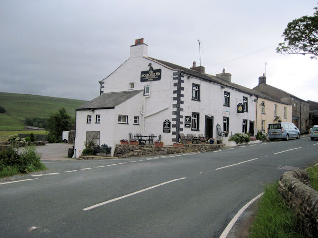
Moorcock Inn

The Moorcock Inn is a public house at the watershed of the Eden, Clough and Ure rivers, in Upper Wensleydale, North Yorkshire, England. It is adjacent...
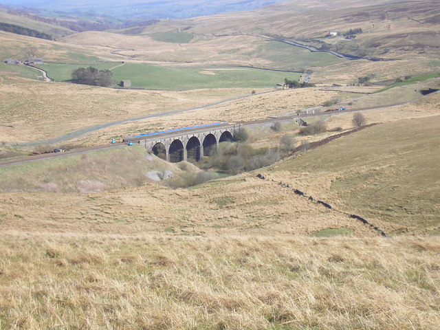
Dandry Mire Viaduct

Dandry Mire Viaduct, (or Dandrymire Viaduct), is a railway viaduct on the Settle & Carlisle line in Cumbria, England. It is just north of Garsdale station...

Garsdale Head

Garsdale Head is a hamlet mainly within the South Lakeland district of Cumbria, England. Historically part of the West Riding of Yorkshire, the hamlet...

Garsdale railway station

Garsdale is a railway station in Cumbria, England (historically in the West Riding of Yorkshire), on the Settle and Carlisle Line, which runs between Carlisle...

Aisgill

Aisgill is the southernmost of the hamlets that form the parish of Mallerstang in the English county of Cumbria. It is on the B6259 road, at the head of...

Nearby Amenities

Located within 500m of 54.34035,-2.3317484
Turner Hill
Ele: 465
Natural: peak
Source: OS OpenData StreetView
Lat/Long: 54.3399128/-2.3354067
Fixme: Confirm stile present
Lat/Long: 54.3364574/-2.3348664
Barrier: stile
Material: stone
Source: survey;gps
Stile: stepover
Lat/Long: 54.3396748/-2.3250276
Barrier: stile
Material: stone
Source: survey;gps
Stile: stepover
Lat/Long: 54.3401781/-2.3245779
Barrier: stile
Material: stone
Source: survey;gps
Stile: squeezer
Lat/Long: 54.3407689/-2.3242544
Anthropogenic: yes
Natural: sinkhole
Lat/Long: 54.3376106/-2.3346466
Anthropogenic: yes
Natural: sinkhole
Lat/Long: 54.3376569/-2.3348739
Anthropogenic: yes
Natural: sinkhole
Lat/Long: 54.3377621/-2.3351048
Anthropogenic: yes
Natural: sinkhole
Lat/Long: 54.3377789/-2.335278
Anthropogenic: yes
Natural: sinkhole
Lat/Long: 54.3377936/-2.3355451
Anthropogenic: yes
Natural: sinkhole
Lat/Long: 54.3378525/-2.3356389
Anthropogenic: yes
Natural: sinkhole
Lat/Long: 54.3379346/-2.3357796
Anthropogenic: yes
Natural: sinkhole
Lat/Long: 54.3380377/-2.3360033
Anthropogenic: yes
Natural: sinkhole
Lat/Long: 54.3380734/-2.3361621
Anthropogenic: yes
Natural: sinkhole
Lat/Long: 54.3380924/-2.3363136
Anthropogenic: yes
Natural: sinkhole
Lat/Long: 54.3380987/-2.3364255
Anthropogenic: yes
Natural: sinkhole
Lat/Long: 54.3381176/-2.3366817
Anthropogenic: yes
Natural: sinkhole
Lat/Long: 54.3381239/-2.3368621
Anthropogenic: yes
Natural: sinkhole
Lat/Long: 54.3380903/-2.3370641
Anthropogenic: yes
Natural: sinkhole
Lat/Long: 54.3380945/-2.3373239
Anthropogenic: yes
Natural: sinkhole
Lat/Long: 54.3381176/-2.337425
Anthropogenic: yes
Natural: sinkhole
Lat/Long: 54.3381386/-2.3375585
Anthropogenic: yes
Natural: sinkhole
Lat/Long: 54.3382165/-2.3377317
Anthropogenic: yes
Natural: sinkhole
Lat/Long: 54.3382964/-2.3379878
Anthropogenic: yes
Natural: sinkhole
Lat/Long: 54.3383511/-2.3381574
Anthropogenic: yes
Natural: sinkhole
Lat/Long: 54.3384563/-2.3384064
Anthropogenic: yes
Natural: sinkhole
Lat/Long: 54.3385615/-2.3386373
Anthropogenic: yes
Natural: sinkhole
Lat/Long: 54.3386519/-2.3387672
Gibson Pasture
Place: locality
Lat/Long: 54.3403466/-2.3304565
Natural: sinkhole
Lat/Long: 54.3443798/-2.3345181
Natural: sinkhole
Lat/Long: 54.3439337/-2.3338196
Natural: sinkhole
Lat/Long: 54.3438211/-2.3337156
Natural: sinkhole
Lat/Long: 54.3437084/-2.3336413
Natural: sinkhole
Lat/Long: 54.3435915/-2.3335447
Natural: sinkhole
Lat/Long: 54.3435438/-2.333515
Natural: sinkhole
Lat/Long: 54.3434962/-2.3339831
Natural: sinkhole
Lat/Long: 54.3436002/-2.3340797
Natural: sinkhole
Lat/Long: 54.3429764/-2.3338939
Natural: sinkhole
Lat/Long: 54.3429635/-2.3336041
Natural: sinkhole
Lat/Long: 54.3429678/-2.3335521
Natural: sinkhole
Lat/Long: 54.3431497/-2.3335075
Natural: sinkhole
Lat/Long: 54.3428032/-2.3334927
Natural: sinkhole
Lat/Long: 54.3426473/-2.333515
Natural: sinkhole
Lat/Long: 54.3426516/-2.3333069
Natural: sinkhole
Lat/Long: 54.342435/-2.3333292
Anthropogenic: yes
Natural: sinkhole
Lat/Long: 54.340482/-2.3325018
Anthropogenic: yes
Natural: sinkhole
Lat/Long: 54.3403134/-2.3326115
Anthropogenic: yes
Natural: sinkhole
Lat/Long: 54.3402088/-2.3326414
Anthropogenic: yes
Natural: sinkhole
Lat/Long: 54.3400461/-2.3327112
Anthropogenic: yes
Natural: sinkhole
Lat/Long: 54.3398253/-2.3327112
Anthropogenic: yes
Natural: sinkhole
Lat/Long: 54.3396161/-2.3328408
Anthropogenic: yes
Natural: sinkhole
Lat/Long: 54.3394649/-2.3328507
Anthropogenic: yes
Natural: sinkhole
Lat/Long: 54.3393385/-2.3330508
Anthropogenic: yes
Natural: sinkhole
Lat/Long: 54.3392983/-2.3331198
Anthropogenic: yes
Natural: sinkhole
Lat/Long: 54.3392379/-2.3332234
Anthropogenic: yes
Natural: sinkhole
Lat/Long: 54.3390447/-2.3333753
Anthropogenic: yes
Natural: sinkhole
Lat/Long: 54.3389642/-2.3334374
Anthropogenic: yes
Natural: sinkhole
Lat/Long: 54.3388998/-2.3334305
Anthropogenic: yes
Natural: sinkhole
Lat/Long: 54.3388032/-2.3333753
Anthropogenic: yes
Natural: sinkhole
Lat/Long: 54.3386704/-2.3334305
Anthropogenic: yes
Natural: sinkhole
Lat/Long: 54.3385658/-2.3335271
Anthropogenic: yes
Natural: sinkhole
Lat/Long: 54.3383524/-2.3336652
Anthropogenic: yes
Natural: sinkhole
Lat/Long: 54.3382518/-2.3334098
Anthropogenic: yes
Natural: sinkhole
Lat/Long: 54.3381472/-2.3333338
Anthropogenic: yes
Natural: sinkhole
Lat/Long: 54.3379781/-2.3332786
Anthropogenic: yes
Natural: sinkhole
Lat/Long: 54.3382317/-2.3341554
Anthropogenic: yes
Natural: sinkhole
Lat/Long: 54.3381592/-2.3341002
Anthropogenic: yes
Natural: sinkhole
Lat/Long: 54.3379862/-2.3339552
Anthropogenic: yes
Natural: sinkhole
Lat/Long: 54.3375917/-2.3340587
Anthropogenic: yes
Natural: sinkhole
Lat/Long: 54.3376682/-2.3341416
Anthropogenic: yes
Natural: sinkhole
Lat/Long: 54.3378252/-2.3340795
Anthropogenic: yes
Natural: sinkhole
Lat/Long: 54.3376964/-2.3338033
Anthropogenic: yes
Natural: sinkhole
Lat/Long: 54.3376762/-2.33361
Anthropogenic: yes
Natural: sinkhole
Lat/Long: 54.3376722/-2.3333062
Anthropogenic: yes
Natural: sinkhole
Lat/Long: 54.3373623/-2.332678
Anthropogenic: yes
Natural: sinkhole
Lat/Long: 54.3375474/-2.3328022
Natural: sinkhole
Lat/Long: 54.3365935/-2.3312626
Natural: sinkhole
Lat/Long: 54.3366096/-2.3314283
Natural: sinkhole
Lat/Long: 54.3367062/-2.3315526
Natural: sinkhole
Lat/Long: 54.3367907/-2.3315319
Natural: sinkhole
Lat/Long: 54.3368793/-2.331525
Natural: sinkhole
Lat/Long: 54.3367384/-2.3294952
Natural: sinkhole
Lat/Long: 54.3367303/-2.3292881
Natural: sinkhole
Lat/Long: 54.3370402/-2.3295233
Natural: sinkhole
Lat/Long: 54.3371852/-2.3295228
Natural: sinkhole
Lat/Long: 54.3368712/-2.3296333
Natural: sinkhole
Lat/Long: 54.3368712/-2.3294745
Anthropogenic: yes
Natural: sinkhole
Lat/Long: 54.3362795/-2.3322016
Anthropogenic: yes
Natural: sinkhole
Lat/Long: 54.3361869/-2.332174
Anthropogenic: yes
Natural: sinkhole
Lat/Long: 54.3360018/-2.3320635
The data included in this document is from www.openstreetmap.org. The data is made available under ODbL.

Have you been to Gibson Pasture?

Leave your review of Gibson Pasture below (or comments, questions and feedback).