Handsworth

Settlement in Yorkshire

England

Handsworth

Olivers Mount - Home of Handsworth FC FA Cup 1st Qualifying Round : Handsworth FC 2 Coventry United 0, Attendance 368
This is the new ground of a fairly new team, though it is hard to figure out exactly how long the real club goes back, it having emerged from an older one of the same name via mergers, name changes, and various relocations. Existence is sometimes tough in Tier 9 of the football pyramid it seems. (Tier 1 is the Premier League, so theoretically if Handsworth top their leagues, win playoffs, and carry out necessary ground improvements along the way, they could be kicking off against Manchester United in eight years time.)
The pitch is artificial, but there is a tannoy, as well as a bar in the clubhouse, which is further South at the entrance by the cricket field. Handsworth currently play in the Northern Counties East League Premier Division. Obviously the rules regarding alcohol in normal fixtures differ from FA-run competitions - repeated announcements were made advising spectators that today beers would not be allowed to be carried from the clubhouse to the playing area.
All clubs in the pyramid leagues down to Tier 10 can enter the FA Cup if they fulfil certain criteria - which most do - and decide they want to. The prize money for winning today's tie was £2,250.
Olivers Mount - Home of Handsworth FC Credit: Ian Dodds

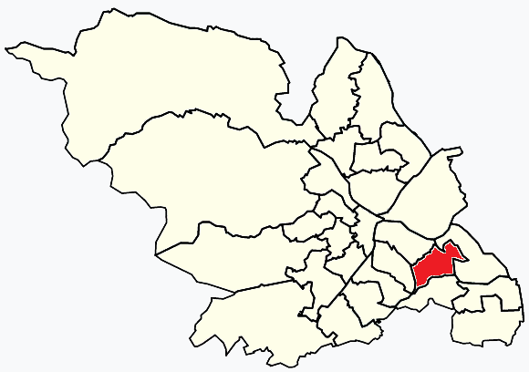
Handsworth is a suburban area located in the city of Sheffield, Yorkshire, in the north of England. It is situated approximately 5 miles southeast of the city center. Handsworth is part of the larger metropolitan borough of Sheffield and falls within the parliamentary constituency of Sheffield South East.

Historically, Handsworth was a small rural village until the 19th century when industrialization led to its rapid growth. Today, it is a predominantly residential area with a mix of housing types, including post-war council estates, modern developments, and traditional stone-built houses. The population of Handsworth is diverse, consisting of families, professionals, and retirees.

The area boasts a range of amenities and services to cater to its residents. There are several primary and secondary schools, ensuring quality education for local children. Handsworth also benefits from various green spaces, such as Handsworth Park and Richmond Park, which provide opportunities for outdoor activities and leisure.

Handsworth has good transport links, with regular bus services connecting it to Sheffield city center and surrounding areas. The nearby M1 motorway provides easy access to other parts of Yorkshire, as well as major cities like Leeds and Manchester.

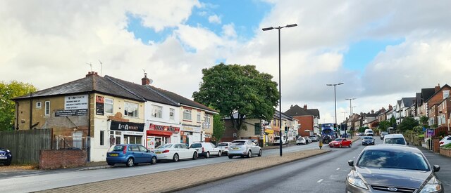
In terms of local facilities, Handsworth has a number of shops, supermarkets, and eateries that cater to everyday needs. Additionally, there are community centers, sports clubs, and a library, offering a range of activities and services for residents of all ages.

Overall, Handsworth is a vibrant and well-connected suburban area within Sheffield, offering a mix of housing options, amenities, and green spaces, making it an attractive place to live.

If you have any feedback on the listing, please let us know in the comments section below.
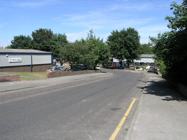
Handsworth Images

Images are sourced within 2km of 53.371637/-1.391246 or Grid Reference SK4086. Thanks to Geograph Open Source API. All images are credited.

Olivers Mount - Home of Handsworth FC FA Cup 1st Qualifying Round : Handsworth FC 2 Coventry United 0, Attendance 368
This is the new ground of a fairly new team, though it is hard to figure out exactly how long the real club goes back, it having emerged from an older one of the same name via mergers, name changes, and various relocations. Existence is sometimes tough in Tier 9 of the football pyramid it seems. (Tier 1 is the Premier League, so theoretically if Handsworth top their leagues, win playoffs, and carry out necessary ground improvements along the way, they could be kicking off against Manchester United in eight years time.)
The pitch is artificial, but there is a tannoy, as well as a bar in the clubhouse, which is further South at the entrance by the cricket field. Handsworth currently play in the Northern Counties East League Premier Division. Obviously the rules regarding alcohol in normal fixtures differ from FA-run competitions - repeated announcements were made advising spectators that today beers would not be allowed to be carried from the clubhouse to the playing area.
All clubs in the pyramid leagues down to Tier 10 can enter the FA Cup if they fulfil certain criteria - which most do - and decide they want to. The prize money for winning today's tie was £2,250.
Olivers Mount - Home of Handsworth FC
FA Cup 1st Qualifying Round : Handsworth FC 2 Coventry United 0, Attendance 368 This is the new ground of a fairly new team, though it is hard to figure out exactly how long the real club goes back, it having emerged from an older one of the same name via mergers, name changes, and various relocations. Existence is sometimes tough in Tier 9 of the football pyramid it seems. (Tier 1 is the Premier League, so theoretically if Handsworth top their leagues, win playoffs, and carry out necessary ground improvements along the way, they could be kicking off against Manchester United in eight years time.) The pitch is artificial, but there is a tannoy, as well as a bar in the clubhouse, which is further South at the entrance by the cricket field. Handsworth currently play in the Northern Counties East League Premier Division. Obviously the rules regarding alcohol in normal fixtures differ from FA-run competitions - repeated announcements were made advising spectators that today beers would not be allowed to be carried from the clubhouse to the playing area. All clubs in the pyramid leagues down to Tier 10 can enter the FA Cup if they fulfil certain criteria - which most do - and decide they want to. The prize money for winning today's tie was £2,250.
Shops on Handsworth Road
The New Anglers Formerly the Anglers Rest <a href="https://www.geograph.org.uk/photo/2971016">SK4086 : The Anglers Rest</a>.
The New Anglers
Formerly the Anglers Rest SK4086 : The Anglers Rest.
The sign of The New Anglers Not looking that new! Also <a href="https://www.geograph.org.uk/photo/7448947">SK4086 : The New Anglers</a>
The sign of The New Anglers
Not looking that new! Also SK4086 : The New Anglers
Entrance path to Woodhouse Health Centre
Retford Road, Handsworth The view down Retford Road, Handsworth. Formerly known as the A57 (now B6200) prior to completion of the bypass which now skirts Mosborough and Beighton before meeting up with the M1 at Junction 31, this road is still heavily used as one of the main arterial roads into Sheffield from Woodhouse, Aston and Worksop. Just down the road on this south-east view, the road splits right to head off to Woodhouse. The photo is taken close to the (apparent) location of a milepost showing 5 miles to Sheffield and 13 to Worksop (according to the 1905 maps).
Retford Road, Handsworth
The view down Retford Road, Handsworth. Formerly known as the A57 (now B6200) prior to completion of the bypass which now skirts Mosborough and Beighton before meeting up with the M1 at Junction 31, this road is still heavily used as one of the main arterial roads into Sheffield from Woodhouse, Aston and Worksop. Just down the road on this south-east view, the road splits right to head off to Woodhouse. The photo is taken close to the (apparent) location of a milepost showing 5 miles to Sheffield and 13 to Worksop (according to the 1905 maps).
Norfolk Arms, Handsworth One of the old pubs in the area, the Norfolk Arms is identified on the 1901 OS map. Just down the road from here, Benjamin Huntsman, inventor of crucible steel lived for a while in 1742,
Norfolk Arms, Handsworth
One of the old pubs in the area, the Norfolk Arms is identified on the 1901 OS map. Just down the road from here, Benjamin Huntsman, inventor of crucible steel lived for a while in 1742,
Handsworth School Taken at the Junction of St. Josephs Road and Fitzalan Road, Showing Handsworth School prior to its demolition in January 2004. The school was opened on 10th February  1902 and finally closed in 1995.
Handsworth School
Taken at the Junction of St. Josephs Road and Fitzalan Road, Showing Handsworth School prior to its demolition in January 2004. The school was opened on 10th February 1902 and finally closed in 1995.
Handsworth School Taken at the Junction of Hall Road and Fitzalan Road, Showing Handsworth School prior to its demolition in January 2004. The school opened on 10th February  1902 and finally closed in 1995.
Handsworth School
Taken at the Junction of Hall Road and Fitzalan Road, Showing Handsworth School prior to its demolition in January 2004. The school opened on 10th February 1902 and finally closed in 1995.
Handsworth School Taken from over the wall in Hall Road, Showing Handsworth School prior to its demolition in January 2004. The school opened on 10th February  1902 and finally closed in 1995.
Handsworth School
Taken from over the wall in Hall Road, Showing Handsworth School prior to its demolition in January 2004. The school opened on 10th February 1902 and finally closed in 1995.
Footbridge over railway at Handsworth Located about halfway between Woodhouse and Darnall Stations, serving the footpath  from the old Handsworth Colliery to Orgreave (Now B6066 High Field Spring). The Railway marking the boundary between Sheffield and Rotherham. In the distance can be seen the Sheffield Parkway, housing estates of Brinsworth and Canklow Wood.
Footbridge over railway at Handsworth
Located about halfway between Woodhouse and Darnall Stations, serving the footpath from the old Handsworth Colliery to Orgreave (Now B6066 High Field Spring). The Railway marking the boundary between Sheffield and Rotherham. In the distance can be seen the Sheffield Parkway, housing estates of Brinsworth and Canklow Wood.
Waverley Advanced Manufacturing Park Waverley Advanced Manufacturing Park under construction, B6066 High Field Spring to the right.
Waverley Advanced Manufacturing Park
Waverley Advanced Manufacturing Park under construction, B6066 High Field Spring to the right.
Highfield Spring B6066 B6066 High Field Spring heading toward the Waverley Advanced Manufacturing Park, with factory under construction for TWI, former open cast workings to the right and Morrison's (Catcliffe) in the distance.
Highfield Spring B6066
B6066 High Field Spring heading toward the Waverley Advanced Manufacturing Park, with factory under construction for TWI, former open cast workings to the right and Morrison's (Catcliffe) in the distance.
Waverley Advanced Manufacturing Park Waverley Advanced Manufacturing Park under construction, B6066 High Field Spring to the right, Rotherham in the distance.
Waverley Advanced Manufacturing Park
Waverley Advanced Manufacturing Park under construction, B6066 High Field Spring to the right, Rotherham in the distance.
South Yorkshire Fire Training School Formerly St John Fisher RC Secondary School back when I were a lad (1970's / 80s), this is now the training centre for South Yorkshire Fire and Rescue. The centre is on Beaver Hill Road between Handsworth and Woodhouse.
South Yorkshire Fire Training School
Formerly St John Fisher RC Secondary School back when I were a lad (1970's / 80s), this is now the training centre for South Yorkshire Fire and Rescue. The centre is on Beaver Hill Road between Handsworth and Woodhouse.
Beaver Hill Road, Woodhouse From outside the fire service training centre <a href="https://www.geograph.org.uk/photo/193087">SK4185 : South Yorkshire Fire Training School</a>, this image looks down Beaver Hill Road towards Woodhouse. In the bottom, just visible is the bridge crossing Shirtcliff Brook.
Beaver Hill Road, Woodhouse
From outside the fire service training centre SK4185 : South Yorkshire Fire Training School, this image looks down Beaver Hill Road towards Woodhouse. In the bottom, just visible is the bridge crossing Shirtcliff Brook.
Remains of Nether Wheel, Woodhouse Along with <a href="https://www.geograph.org.uk/photo/194486">SK4184 : Carr Forge Dam</a>, the Nether Wheel was yet another of the waterwheels along the Shirebrook Valley. This one still has visible remains of the buildings, buried in woodland although accessible by waymarked footpaths. This wheel probably drove grinding stones or similar for the manufacture of agricultural tools.
Remains of Nether Wheel, Woodhouse
Along with SK4184 : Carr Forge Dam, the Nether Wheel was yet another of the waterwheels along the Shirebrook Valley. This one still has visible remains of the buildings, buried in woodland although accessible by waymarked footpaths. This wheel probably drove grinding stones or similar for the manufacture of agricultural tools.
Orgreave Crescent Orgreave Crescent is just a part of the large Dore House industrial estate.
Orgreave Crescent
Orgreave Crescent is just a part of the large Dore House industrial estate.
Show me another place!

Handsworth is located at Grid Ref: SK4086 (Lat: 53.371637, Lng: -1.391246)

Division: West Riding

Unitary Authority: Sheffield

Police Authority: South Yorkshire

What 3 Words

///rich.breath.noble. Near Orgreave, South Yorkshire

Nearby Locations

Handsworth

Related Wikis

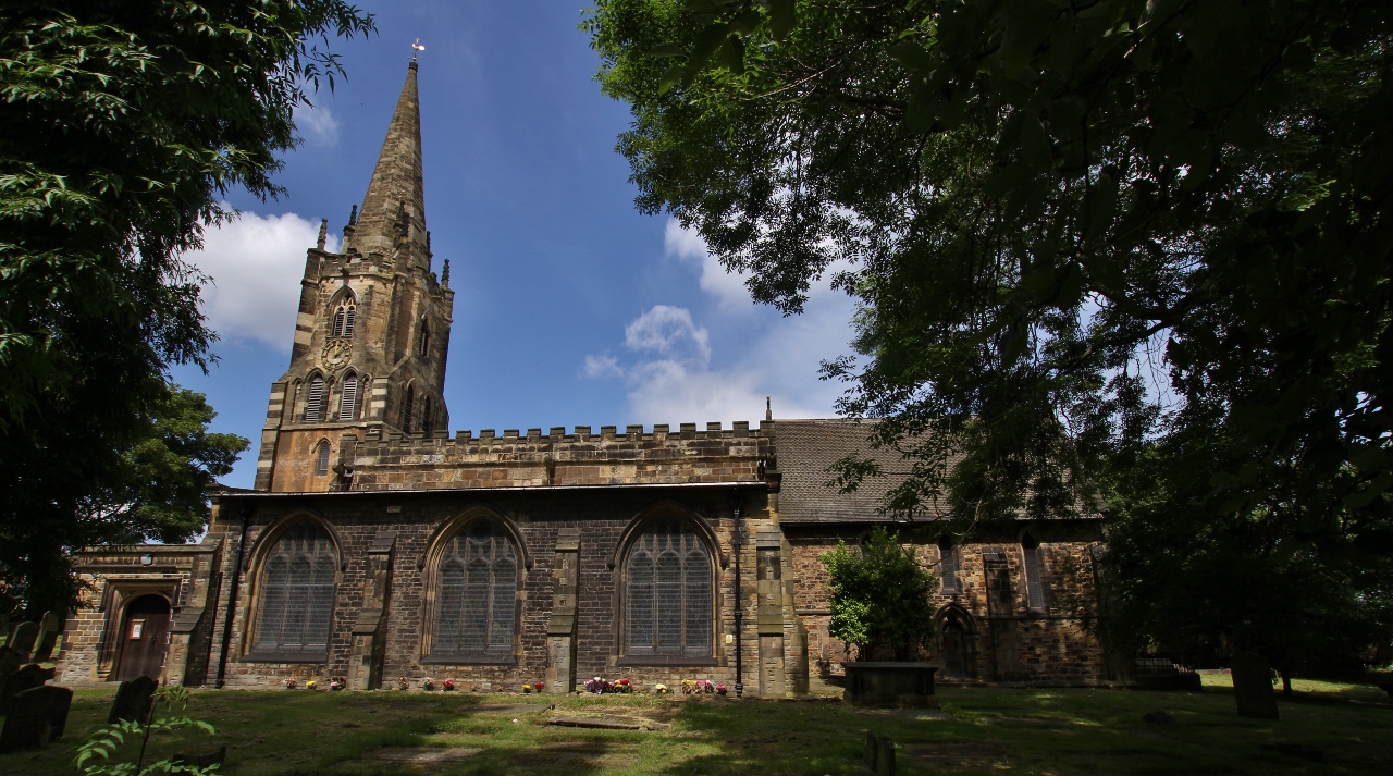
St Mary's Church, Handsworth, Sheffield

St Mary's Church in Handsworth, South Yorkshire, is a Church of England parish church about 3+1⁄2 miles (5.6 km) east of the centre of Sheffield, England...

Handsworth, South Yorkshire

Handsworth is a suburb of south eastern Sheffield, in South Yorkshire, England. It covers an area of approximately 5 square miles (13 km2), and has a population...

Richmond, Sheffield

Richmond is a suburb of Sheffield in South Yorkshire, England. It lies in the eastern part of the city (grid reference SK403854). Richmond was historically...

Bowden Housteads Woods

Bowden Housteads Woods are situated between Darnall and Handsworth, Sheffield, South Yorkshire, England. The woods are encircled by Sheffield Outer Ring...

Parkway Man

The Parkway Man, also known locally as "Iron Henry" (even though it represents a steelworker) is a statue located in Bowden Housteads Woods in the Handsworth...

Handsworth Grange Community Sports College

Handsworth Grange Community Sports College also known as Handsworth Grange School is an academy and part of the Minerva Learning Trust. It is located in...

Orgreave, South Yorkshire

Orgreave is a village and civil parish on the River Rother in South Yorkshire. It is in the Metropolitan Borough of Rotherham, about 4.5 miles (7 km) east...
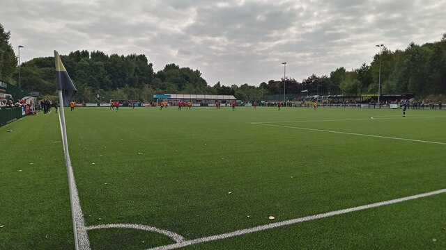
Handsworth F.C.

Handsworth Football Club is a football club based in Handsworth, Sheffield, South Yorkshire, England. They are currently members of the Northern Counties...

Nearby Amenities

Located within 500m of 53.371637,-1.391246
Bus Stop
Richmond Road/Richmond Grove
Alt Name: Richmond Road/Richmond Grove
Bench: yes
Bin: no
Bus: yes
Naptan AltCommonName: Richmond Road/Richmond Grove
Naptan AtcoCode: 370022724
Naptan Bearing: SW
Naptan CommonName: Richmond Road/Richmond Grove
Naptan Indicator: 22724
Naptan Landmark: 22724
Naptan PlusbusZoneRef: ROTHCEN
Naptan Street: Richmond Road
Naptan Verified: no
Public Transport: platform
Shelter: yes
Source: naptan_import
Tactile Paving: no
Lat/Long: 53.3686128/-1.3954354
Bus Stop
Richmond Park Road/Richmond Road
Bus: yes
Naptan AtcoCode: 370022726
Naptan Bearing: S
Naptan CommonName: Richmond Park Road/Richmond Road
Naptan Indicator: 22726
Naptan Landmark: 22726
Naptan PlusbusZoneRef: ROTHCEN
Naptan Street: Richmond Park Road
Naptan Verified: no
Public Transport: platform
Source: naptan_import
Lat/Long: 53.3687613/-1.3963651
Bus Stop
Richmond Park Road/Wheatley Grove
Alt Name: Richmond Park Road/Wheatley Grove
Bus: yes
Naptan AltCommonName: Richmond Park Road/Wheatley Grove
Naptan AtcoCode: 370022740
Naptan Bearing: N
Naptan CommonName: Richmond Park Road/Wheatley Grove
Naptan Indicator: 22740
Naptan Landmark: 22740
Naptan PlusbusZoneRef: ROTHCEN
Naptan Street: Richmond Park Road
Naptan Verified: no
Public Transport: platform
Source: naptan_import
Lat/Long: 53.3692579/-1.396809
Bus Stop
Richmond Park Road/Athelstan Road
Alt Name: Richmond Park Road/Athelstan Road
Bus: yes
Naptan AltCommonName: Richmond Park Road/Athelstan Road
Naptan AtcoCode: 370022741
Naptan Bearing: S
Naptan CommonName: Richmond Park Road/Athelstan Road
Naptan Indicator: 22741
Naptan Landmark: ANGLERS REST PUB
Naptan PlusbusZoneRef: ROTHCEN
Naptan Street: Richmond Park Road
Naptan Verified: no
Public Transport: platform
Source: naptan_import
Lat/Long: 53.371298/-1.39672
Bus Stop
Richmond Park Rd/Athelstan Road
Alt Name: Richmond Park Rd/Athelstan Road
Bus: yes
Naptan AltCommonName: Richmond Park Rd/Athelstan Road
Naptan AtcoCode: 370022742
Naptan Bearing: N
Naptan CommonName: Richmond Park Rd/Athelstan Road
Naptan Indicator: 22742
Naptan Landmark: ANGLERS REST PUB
Naptan PlusbusZoneRef: ROTHCEN
Naptan Street: Richmond Park Road
Naptan Verified: no
Public Transport: platform
Source: naptan_import
Lat/Long: 53.371566/-1.3971796
Bus Stop
Richmond Park Road/Richmond Park Avenue
Alt Name: Richmond Park Road/Richmond Park Avenue
Bus: yes
Naptan AltCommonName: Richmond Park Road/Richmond Park Avenue
Naptan AtcoCode: 370022743
Naptan Bearing: S
Naptan CommonName: Richmond Park Road/Richmond Park Avenue
Naptan Indicator: 22743
Naptan Landmark: 22743
Naptan PlusbusZoneRef: ROTHCEN
Naptan Street: Richmond Park Road
Naptan Verified: no
Public Transport: platform
Source: naptan_import
Lat/Long: 53.3732318/-1.3969633
Bus Stop
Richmond Park Road/Richmond Park Avenue
Alt Name: Richmond Park Road/Richmond Park Avenue
Bus: yes
Naptan AltCommonName: Richmond Park Road/Richmond Park Avenue
Naptan AtcoCode: 370022744
Naptan Bearing: NE
Naptan CommonName: Richmond Park Road/Richmond Park Avenue
Naptan Indicator: 22744
Naptan Landmark: 22744
Naptan PlusbusZoneRef: ROTHCEN
Naptan Street: Richmond Park Road
Naptan Verified: no
Public Transport: platform
Source: naptan_import
Lat/Long: 53.3736285/-1.3971982
Bus Stop
Richmond Park Road/Richmond Park Crescent
Bus: yes
Naptan AtcoCode: 370022745
Naptan Bearing: N
Naptan CommonName: Richmond Park Road/Richmond Park Crescent
Naptan Indicator: 22745
Naptan Landmark: OUTSIDE REMPLOY
Naptan PlusbusZoneRef: ROTHCEN
Naptan Street: Richmond Park Road
Naptan Verified: no
Public Transport: platform
Source: naptan_import
Lat/Long: 53.3748786/-1.3955421
Bus Stop
Richmond Park Road/Richmond Park Crescent
Bus: yes
Naptan AtcoCode: 370022746
Naptan Bearing: N
Naptan CommonName: Richmond Park Road/Richmond Park Crescent
Naptan Indicator: 22746
Naptan Landmark: PORTLAND BUSINESS PARK
Naptan PlusbusZoneRef: ROTHCEN
Naptan Street: Richmond Park Road
Naptan Verified: no
Public Transport: platform
Source: naptan_import
Lat/Long: 53.374957/-1.3950449
Bus Stop
Handsworth Road/Richmond Park Road
Bus: yes
Naptan AtcoCode: 370022750
Naptan Bearing: SE
Naptan CommonName: Handsworth Road/Richmond Park Road
Naptan Indicator: 22750
Naptan Landmark: 22750
Naptan PlusbusZoneRef: ROTHCEN
Naptan Street: Handsworth Road
Naptan Verified: no
Public Transport: platform
Source: naptan_import
Lat/Long: 53.3755305/-1.3929543
Bus Stop
Handsworth Road/Finchwell Road
Bus: yes
Naptan AtcoCode: 370022751
Naptan Bearing: NW
Naptan CommonName: Handsworth Road/Finchwell Road
Naptan Indicator: 22751
Naptan Landmark: Outside Gray Printing
Naptan PlusbusZoneRef: ROTHCEN
Naptan Street: Handsworth Road
Naptan Verified: no
Public Transport: platform
Source: naptan_import
Lat/Long: 53.3749715/-1.3925946
Bus Stop
Handsworth Road/Finchwell Road
Bus: yes
Naptan AtcoCode: 370022752
Naptan Bearing: SE
Naptan CommonName: Handsworth Road/Finchwell Road
Naptan Indicator: 22752
Naptan Landmark: 22752
Naptan PlusbusZoneRef: ROTHCEN
Naptan Street: Handsworth Road
Naptan Verified: no
Public Transport: platform
Source: naptan_import
Lat/Long: 53.3742178/-1.3911821
Bus Stop
Handsworth Road/Methodist Church
Alt Name: Handsworth Road/Methodist Church
Bus: yes
Naptan AltCommonName: Handsworth Road/Methodist Church
Naptan AtcoCode: 370022753
Naptan Bearing: N
Naptan CommonName: Handsworth Road/Methodist Church
Naptan Indicator: 22753
Naptan Landmark: Methodist Church
Naptan PlusbusZoneRef: ROTHCEN
Naptan Street: Handsworth Road
Naptan Verified: no
Public Transport: platform
Source: naptan_import
Lat/Long: 53.373145/-1.3901425
Bus Stop
Handsworth Road/Fitzalan Road
Alt Name: Handsworth Road/Fitzalan Road
Bus: yes
Naptan AltCommonName: Handsworth Road/Fitzalan Road
Naptan AtcoCode: 370022754
Naptan Bearing: N
Naptan CommonName: Handsworth Road/Fitzalan Road
Naptan Indicator: 22754
Naptan Landmark: Methodist Church
Naptan PlusbusZoneRef: ROTHCEN
Naptan Street: Handsworth Road
Naptan Verified: no
Public Transport: platform
Source: naptan_import
Lat/Long: 53.373/-1.3896077
Bus Stop
Handsworth Road/Richmond Road
Bus: yes
Naptan AtcoCode: 370022755
Naptan Bearing: E
Naptan CommonName: Handsworth Road/Richmond Road
Naptan Indicator: 22755
Naptan Landmark: CHURCH
Naptan PlusbusZoneRef: ROTHCEN
Naptan Street: Handsworth Road
Naptan Verified: no
Public Transport: platform
Source: naptan_import
Lat/Long: 53.3712546/-1.3864399
Bus Stop
Handsworth Road/Richmond Road
Bus: yes
Naptan AtcoCode: 370022756
Naptan Bearing: W
Naptan CommonName: Handsworth Road/Richmond Road
Naptan Indicator: 22756
Naptan Landmark: Church
Naptan PlusbusZoneRef: ROTHCEN
Naptan Street: Handsworth Road
Naptan Verified: no
Public Transport: platform
Source: naptan_import
Lat/Long: 53.3710342/-1.3860899
Bus Stop
Richmond Park/Bramley Park Road
Alt Name: Richmond Park/Bramley Park Road
Bench: yes
Bin: yes
Bus: yes
Naptan AltCommonName: Richmond Park/Bramley Park Road
Naptan AtcoCode: 370022757
Naptan Bearing: N
Naptan CommonName: Richmond Park/Bramley Park Road
Naptan Indicator: 22757
Naptan Landmark: 22757
Naptan PlusbusZoneRef: ROTHCEN
Naptan Street: Richmond Park
Naptan Verified: no
Public Transport: platform
Shelter: yes
Source: naptan_import
Lat/Long: 53.3701785/-1.3904533
Bus Stop
Richmond Road/Laverack Street
Alt Name: Richmond Road/Laverack Street
Bus: yes
Naptan AltCommonName: Richmond Road/Laverack Street
Naptan AtcoCode: 370022758
Naptan Bearing: N
Naptan CommonName: Richmond Road/Laverack Street
Naptan Indicator: 22758
Naptan Landmark: 22758
Naptan PlusbusZoneRef: ROTHCEN
Naptan Street: Richmond Park
Naptan Verified: no
Public Transport: platform
Source: naptan_import
Lat/Long: 53.3703296/-1.391879
Turning Circle
Lat/Long: 53.3729726/-1.3960547
Turning Circle
Source: Bing
Lat/Long: 53.3717979/-1.3896725
Turning Circle
Source: Bing
Lat/Long: 53.3683072/-1.390604
Source: survey
Lat/Long: 53.3716797/-1.3881334
Traffic Signals
Crossing: no
Lat/Long: 53.3716136/-1.388253
Turning Circle
Lat/Long: 53.3746595/-1.3887254
Turning Circle
Source: Bing
Lat/Long: 53.3693105/-1.3930055
Turning Circle
Source: Bing
Lat/Long: 53.3682747/-1.3955482
Handsworth Road/Richmond Park Road
Bus: yes
Public Transport: stop_position
Lat/Long: 53.3755068/-1.3930132
Handsworth Road/Richmond Road
Bus: yes
Public Transport: stop_position
Lat/Long: 53.3711937/-1.3864489
Handsworth Road/Richmond Road
Bus: yes
Public Transport: stop_position
Lat/Long: 53.3711063/-1.3860953
Handsworth Road/Fitzalan Road
Bus: yes
Public Transport: stop_position
Lat/Long: 53.3729764/-1.3896807
Crossing
Crossing: traffic_signals
Crossing Ref: pelican
Source: survey
Lat/Long: 53.3757836/-1.3935971
Turning Circle
Source: Bing
Lat/Long: 53.3708479/-1.3958618
Turning Circle
Source: Bing
Lat/Long: 53.3716144/-1.3941559
Turning Circle
Source: Bing
Lat/Long: 53.3721265/-1.3948104
Turning Circle
Source: Bing
Lat/Long: 53.3701164/-1.3954611
Turning Circle
Source: Bing
Lat/Long: 53.3677496/-1.3939575
Turning Circle
Source: Bing
Lat/Long: 53.3679464/-1.3947863
Turning Circle
Source: Bing
Lat/Long: 53.3735699/-1.3922596
Turning Circle
Source: Bing
Lat/Long: 53.3753717/-1.3900119
Turning Circle
Source: Bing
Lat/Long: 53.3733459/-1.384304
Car Rental
Thrifty
Branch: Car and Van rental
Brand: Thrifty
Brand Wikidata: Q2429546
Source: I used to live near here
Lat/Long: 53.3750974/-1.3945674
Crossing
Crossing: traffic_signals
Crossing Ref: pelican
Source: survey
Lat/Long: 53.3711773/-1.3870726
Crossing
Crossing: traffic_signals
Crossing Ref: pelican
Source: survey
Lat/Long: 53.3712628/-1.3870599
Salon 229
Shop: beauty
Source: survey
Lat/Long: 53.3747417/-1.3917262
Post Office
Handsworth Post Office
Addr City: Sheffield
Addr Country: GB
Addr Housenumber: 271
Addr Postcode: S13 9BN
Addr Street: Handsworth Road
Brand: Post Office
Brand Wikidata: Q1783168
Opening Hours: Mo-Sa 09:00-17:30
Ref Pol Id: 8594
Source: survey
Website: https://www.postoffice.co.uk/branch-finder/2263408/handsworth
Lat/Long: 53.3734992/-1.3901486
Crossing
Bicycle: yes
Crossing: traffic_signals
Crossing Ref: toucan
Source: survey
Lat/Long: 53.3758184/-1.3934328
Traffic Signals
Crossing: no
Source: survey
Lat/Long: 53.3718078/-1.3881327
Veterinary
Hall Court Veterinary Group
Source: survey
Lat/Long: 53.3747639/-1.3917689
Fast Food
Pronto Pizza
Cuisine: pizza
Source: survey
Lat/Long: 53.3747958/-1.391809
Fast Food
Rainbow Chinese
Addr City: Sheffield
Addr Country: GB
Addr Housenumber: 14
Addr Postcode: S13 8UA
Addr Street: Bramley Park Road
Cuisine: chinese
Fhrs Id: 436866
Phone: +44 114 269 2645
Lat/Long: 53.3699478/-1.3898997
Community Centre
273rd Cub Scouts
Shop: convenience
Lat/Long: 53.3700807/-1.390254
Post Box
Collection Times: Mo-Fr 09:00; Sa 07:00
Post Box Type: wall
Ref: S13 167D
Royal Cypher: EVIIR
Royal Cypher Wikidata: Q33102324
Lat/Long: 53.3713495/-1.3846645
Post Box
Collection Times: Mo-Fr 17:15; Sa 11:00
Post Box Type: pillar
Ref: S13 979
Royal Cypher: EIIR
Royal Cypher Wikidata: Q33102113
Lat/Long: 53.3692788/-1.3867102
Post Box
Collection Times: Mo-Fr 09:00; Sa 07:00
Post Box Type: wall
Ref: S13 491D
Royal Cypher: EVIIR
Royal Cypher Wikidata: Q33102324
Lat/Long: 53.3703371/-1.3920523
Check Date: 2020-06-23
Disused Amenity: pharmacy
Old Name: Lloyds Pharmacy
Lat/Long: 53.3729119/-1.390019
Post Box
Collection Times: Mo-Fr 17:00; Sa 12:00
Post Box Type: pillar
Ref: S13 500
Royal Cypher: EIIR
Royal Cypher Wikidata: Q33102113
Lat/Long: 53.3734724/-1.3902084
Dentist
Healthcare: dentist
Lat/Long: 53.3735992/-1.3902698
Entrance: yes
Lat/Long: 53.3750484/-1.3930267
Post Box
Collection Times: Mo-Fr 09:00; Sa 07:00
Post Box Type: pillar
Ref: S13 744D
Royal Cypher: GVIR
Royal Cypher Wikidata: Q33102169
Lat/Long: 53.3717697/-1.3975144
Handsworth Road/Methodist Church
Bus: yes
Public Transport: stop_position
Lat/Long: 53.3731644/-1.390074
Handsworth Road/Finchwell Road
Bus: yes
Public Transport: stop_position
Lat/Long: 53.3741956/-1.391243
Handsworth Road/Finchwell Road
Bus: yes
Public Transport: stop_position
Lat/Long: 53.375017/-1.3925204
Defibrillator
Access: yes
Check Date: 2023-03-09
Defibrillator Location: On outside wall. Available 24/7.
Emergency: defibrillator
Indoor: no
Opening Hours: 24/7
Lat/Long: 53.3727054/-1.3858152
Bench
Backrest: yes
Lat/Long: 53.371211/-1.3850046
Traffic Signals
Crossing: no
Lat/Long: 53.3711608/-1.3869931
Traffic Signals
Crossing: no
Lat/Long: 53.371278/-1.3871178
Traffic Signals
Crossing: no
Lat/Long: 53.3715696/-1.3879714
Crossing
Button Operated: yes
Crossing: traffic_signals
Crossing Island: no
Tactile Paving: yes
Lat/Long: 53.373047/-1.3899312
Crossing
Button Operated: yes
Crossing: traffic_signals
Crossing Island: no
Tactile Paving: yes
Lat/Long: 53.373138/-1.3898829
Traffic Signals
Crossing: no
Lat/Long: 53.3730106/-1.3898885
Traffic Signals
Crossing: no
Lat/Long: 53.3731687/-1.3899214
Crossing
Button Operated: yes
Crossing: traffic_signals
Crossing Island: no
Tactile Paving: yes
Lat/Long: 53.3746816/-1.3920559
Crossing
Button Operated: yes
Crossing: traffic_signals
Crossing Island: no
Tactile Paving: yes
Lat/Long: 53.3746803/-1.3918772
Traffic Signals
Crossing: no
Lat/Long: 53.3747128/-1.3919203
Traffic Signals
Crossing: no
Lat/Long: 53.3746448/-1.3920081
Traffic Signals
Crossing: no
Lat/Long: 53.3749257/-1.3922147
Crossing
Crossing: unmarked
Crossing Island: no
Tactile Paving: yes
Lat/Long: 53.3748464/-1.3919713
Traffic Signals
Crossing: no
Traffic Signals Direction: forward
Lat/Long: 53.3748964/-1.3918807
Crossing
Bicycle: yes
Button Operated: yes
Crossing: traffic_signals
Crossing Island: no
Crossing Ref: toucan
Tactile Paving: yes
Lat/Long: 53.37583/-1.3938048
Traffic Signals
Crossing: no
Lat/Long: 53.3757453/-1.393539
Traffic Signals
Crossing: no
Lat/Long: 53.3758513/-1.3934813
Grit Bin
Operator: Sheffield City Council
Operator Type: government
Operator Wikidata: Q7492609
Seasonal: no
Lat/Long: 53.3719285/-1.3896246
Grit Bin
Operator: Sheffield City Council
Operator Type: government
Operator Wikidata: Q7492609
Seasonal: no
Lat/Long: 53.3728631/-1.398449
Grit Bin
Operator: Sheffield City Council
Operator Type: government
Operator Wikidata: Q7492609
Seasonal: no
Lat/Long: 53.3711062/-1.3958436
Grit Bin
Operator: Sheffield City Council
Operator Type: government
Operator Wikidata: Q7492609
Seasonal: no
Lat/Long: 53.3754549/-1.3901755
Grit Bin
Operator: Sheffield City Council
Operator Type: government
Operator Wikidata: Q7492609
Seasonal: no
Lat/Long: 53.3684214/-1.3928457
Grit Bin
Operator: Sheffield City Council
Operator Type: government
Operator Wikidata: Q7492609
Seasonal: no
Lat/Long: 53.3734512/-1.3974337
Grit Bin
Operator: Sheffield City Council
Operator Type: government
Operator Wikidata: Q7492609
Seasonal: no
Lat/Long: 53.3685645/-1.3962552
Grit Bin
Operator: Sheffield City Council
Operator Type: government
Operator Wikidata: Q7492609
Seasonal: no
Lat/Long: 53.3711619/-1.3873511
The data included in this document is from www.openstreetmap.org. The data is made available under ODbL.

Have you been to Handsworth?

Leave your review of Handsworth below (or comments, questions and feedback).