Winter Hill Flats

Downs, Moorland in Lancashire

England

Winter Hill Flats

Path from Winter Hill to  Rivington Pike A very boggy section of the path. View of the South Lancashire plain beyond.
Path from Winter Hill to Rivington Pike Credit: Oliver Dixon

Winter Hill Flats is a prominent geographical feature situated in the county of Lancashire, England. Located between the towns of Horwich and Belmont, it forms part of the West Pennine Moors, offering breathtaking views and a rich diversity of flora and fauna.

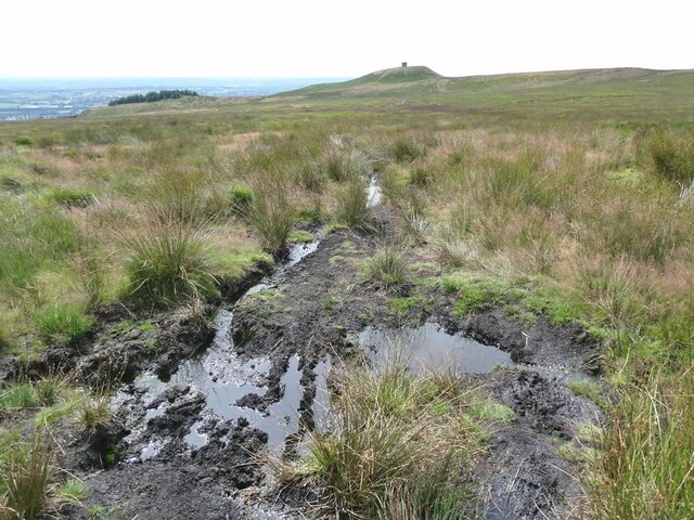
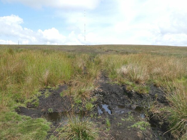
Standing at an elevation of 1,496 feet (456 meters), Winter Hill Flats is renowned for its heather-covered moorland, which blankets the undulating landscape. The area is a designated Site of Special Scientific Interest (SSSI) due to its unique ecological characteristics and its importance as a habitat for various bird species, including the elusive hen harrier and the red grouse.

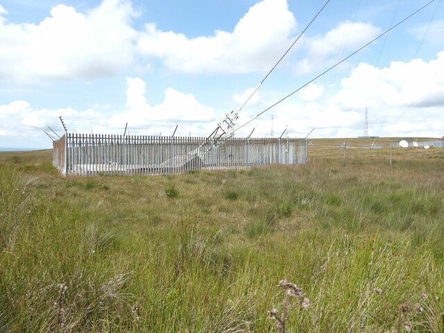
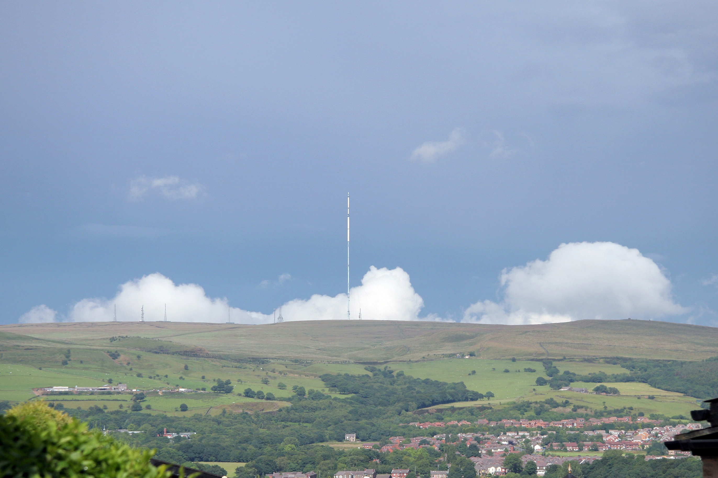
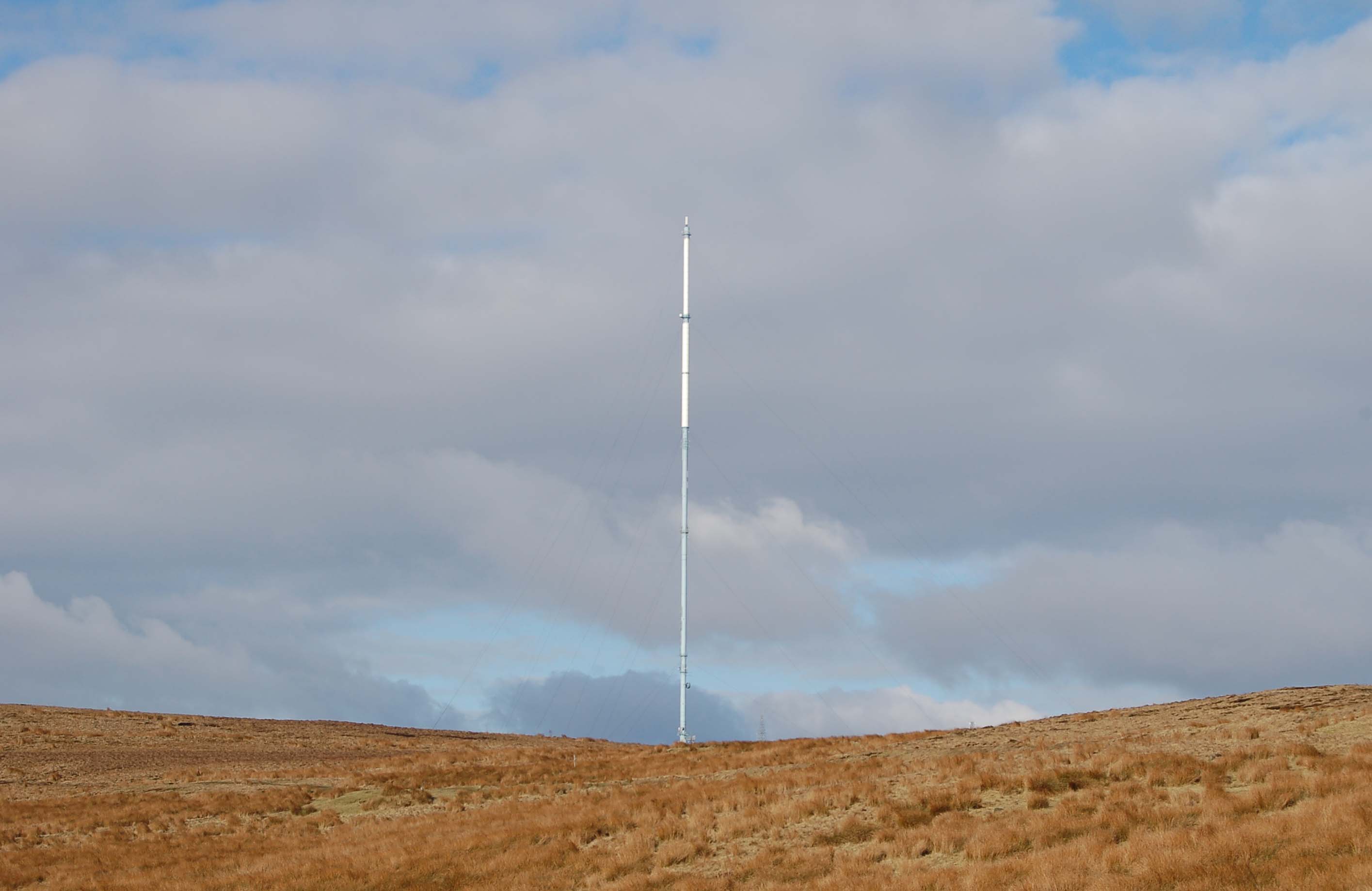
The flats are also home to the iconic Winter Hill transmitting station, a major broadcasting facility that serves the Greater Manchester and Lancashire areas. The mast, standing at an impressive height of 1,036 feet (315 meters), is a prominent landmark visible from miles around.

Outdoor enthusiasts are drawn to Winter Hill Flats due to its extensive network of footpaths and trails, offering opportunities for walking, hiking, and mountain biking. The area is also popular among paragliders and radio-controlled model aircraft enthusiasts, who take advantage of the favorable wind conditions.

Winter Hill Flats has a rich history, having played a significant role in the industrial development of Lancashire. In the past, the area was extensively quarried for stone, and remnants of these activities can still be seen in the form of disused quarries and spoil heaps.

Overall, Winter Hill Flats is a picturesque and diverse landscape, offering a tranquil escape from the hustle and bustle of urban life. Its natural beauty and historical significance make it a cherished destination for visitors and locals alike.

If you have any feedback on the listing, please let us know in the comments section below.

Winter Hill Flats Images

Images are sourced within 2km of 53.633031/-2.5113616 or Grid Reference SD6615. Thanks to Geograph Open Source API. All images are credited.

Path from Winter Hill to  Rivington Pike A very boggy section of the path. View of the South Lancashire plain beyond.
Path from Winter Hill to Rivington Pike
A very boggy section of the path. View of the South Lancashire plain beyond.
Path from Rivington Pike to Winter Hill A very boggy section of the path. The 315 metre high TV mast on Winter Hill <a href="https://www.geograph.org.uk/gridref/SD6614">SD6614</a> dominates the skyline.
Path from Rivington Pike to Winter Hill
A very boggy section of the path. The 315 metre high TV mast on Winter Hill SD6614 dominates the skyline.
Path from Rivington Pike to Winter Hill A muddy path over the moor. Only the lower part of the huge 310 metre high TV mast on Winter Hill <a href="https://www.geograph.org.uk/gridref/SD6614">SD6614</a> is visible on this image.
Path from Rivington Pike to Winter Hill
A muddy path over the moor. Only the lower part of the huge 310 metre high TV mast on Winter Hill SD6614 is visible on this image.
Path from Winter Hill to  Rivington Pike A muddy path over the moor.
Path from Winter Hill to Rivington Pike
A muddy path over the moor.
Path from Winter Hill to  Rivington Pike Bare peat on the upper part of this well-trodden path.
Path from Winter Hill to Rivington Pike
Bare peat on the upper part of this well-trodden path.
Whee! Despite the prohibition notice at the foot of the road, what true cyclist can resist the urge to challenge himself by riding to the summit of Winter Hill, followed by an exhilarating descent back to earth? The "Two Lads" <a href="https://www.geograph.org.uk/gridref/SD6513">SD6513</a> can be seen in the middle distance.
Whee!
Despite the prohibition notice at the foot of the road, what true cyclist can resist the urge to challenge himself by riding to the summit of Winter Hill, followed by an exhilarating descent back to earth? The "Two Lads" SD6513 can be seen in the middle distance.
Cable anchor One of a number of cable anchor points supporting the 310 metre high TV mast on Winter Hill <a href="https://www.geograph.org.uk/gridref/SD6614">SD6614</a>.
Cable anchor
One of a number of cable anchor points supporting the 310 metre high TV mast on Winter Hill SD6614.
Trig pillar on Winter Hill The trig pillar on Winter Hill stands at 436 metres above sea level. In the background, the base of the 310 metre high TV mast (to the right) and three of the seven other masts of assorted purpose which crown the hill.
Trig pillar on Winter Hill
The trig pillar on Winter Hill stands at 436 metres above sea level. In the background, the base of the 310 metre high TV mast (to the right) and three of the seven other masts of assorted purpose which crown the hill.
Cable anchor One of a number of cable anchor points supporting the 310 metre high TV mast on Winter Hill. One of the other aerial masts on the hill in the distance.
Cable anchor
One of a number of cable anchor points supporting the 310 metre high TV mast on Winter Hill. One of the other aerial masts on the hill in the distance.
Road to the aerial masts The road to the westernmost of the aerial masts on Winter Hill is in a pretty poor way. In view, four of the seven smaller masts.
Road to the aerial masts
The road to the westernmost of the aerial masts on Winter Hill is in a pretty poor way. In view, four of the seven smaller masts.
Fence line on the north side of Winter Hill Looking north-west.
Fence line on the north side of Winter Hill
Looking north-west.
Fence line on the north side of Winter Hill Looking east. In view, three of the smaller aerial masts.
Fence line on the north side of Winter Hill
Looking east. In view, three of the smaller aerial masts.
Path on the summit of Winter Hill Flagstones have been laid to protect the moorland surface. On the skyline, three  of the enclosures surrounding cable anchor points for the TV mast. Also one of the lesser aerial masts.
Path on the summit of Winter Hill
Flagstones have been laid to protect the moorland surface. On the skyline, three of the enclosures surrounding cable anchor points for the TV mast. Also one of the lesser aerial masts.
Sheep on the path On top of Winter Hill. Flagstones have been laid along the path to protect the moorland surface.
Sheep on the path
On top of Winter Hill. Flagstones have been laid along the path to protect the moorland surface.
TV mast on Winter Hill The impressive 310 metre high TV mast erected in 1966 replacing an earlier lower mast. It is of tubular design with a diameter of 2.75 metres to facilitate maintenance and is secured against wind damage by fifteen cable attached to the mast at five different levels. It serves a population of 6.3 million people in north-west England and north Wales.

In the background, the buildings associated with the mast, and four of the seven smaller aerial masts which crown the hill.
TV mast on Winter Hill
The impressive 310 metre high TV mast erected in 1966 replacing an earlier lower mast. It is of tubular design with a diameter of 2.75 metres to facilitate maintenance and is secured against wind damage by fifteen cable attached to the mast at five different levels. It serves a population of 6.3 million people in north-west England and north Wales. In the background, the buildings associated with the mast, and four of the seven smaller aerial masts which crown the hill.
TV mast buildings There is quite a cluster of buildings on the summit of Winter Hill servicing the TV mast.
TV mast buildings
There is quite a cluster of buildings on the summit of Winter Hill servicing the TV mast.
Cable anchor One of a number of cable anchor points supporting the 310 metre high TV mast on Winter Hill.
Cable anchor
One of a number of cable anchor points supporting the 310 metre high TV mast on Winter Hill.
Gatepost and memorial on Winter Hill The plaque on the gatepost commemorates the aircraft crash on Winter Hill on 27th February, 1958 in which 35 members of the motor trade from the Isle of Man died.
Gatepost and memorial on Winter Hill
The plaque on the gatepost commemorates the aircraft crash on Winter Hill on 27th February, 1958 in which 35 members of the motor trade from the Isle of Man died.
Show me another place!

Winter Hill Flats is located at Grid Ref: SD6615 (Lat: 53.633031, Lng: -2.5113616)

Unitary Authority: Blackburn with Darwen

Police Authority: Lancashire

What 3 Words

///magically.situated.acquaint. Near Horwich, Manchester

Nearby Locations

Winter Hill Flats

Related Wikis

Winter Hill (North West England)

Winter Hill is a hill on which the three boroughs of Chorley, Blackburn with Darwen and Bolton meet in North West England. It is located on Rivington Moor...

Winter Hill air disaster

The Winter Hill air disaster occurred on 27 February 1958, when the Silver City Airways Bristol 170 Freighter G-AICS, operated by Manx Airlines on a charter...

Winter Hill transmitting station

The Winter Hill transmitting station is a broadcasting and telecommunications site on Winter Hill, at the southern boundary of the Borough of Chorley,...

Ward's Reservoir

Ward's Reservoir (or Wards Reservoir), known locally as the Blue Lagoon, is a small reservoir close to the village of Belmont, Lancashire, England. It...

Nearby Amenities

Located within 500m of 53.633031,-2.5113616
Winter Hill
Ele: 456
Man Made: survey_point
Natural: peak
Ref: 2999
Wikidata: Q8026257
Wikipedia: en:Winter Hill (North West England)
Lat/Long: 53.6298201/-2.5158986
Man Made: tower
Tower Type: communication
Lat/Long: 53.6291039/-2.5149304
BT Horwich
Man Made: tower
Tower Construction: lattice_steel
Tower Type: communication
Lat/Long: 53.6286704/-2.5129533
Barrier: kissing_gate
Lat/Long: 53.6300275/-2.516045
Barrier: stile
Lat/Long: 53.6287744/-2.51338
The data included in this document is from www.openstreetmap.org. The data is made available under ODbL.

Have you been to Winter Hill Flats?

Leave your review of Winter Hill Flats below (or comments, questions and feedback).