Mowberry Road Open Space

Downs, Moorland in Somerset

England

Mowberry Road Open Space

Filwood, Bristol, Christ the King Catholic Church "Knowle West"
Filwood, Bristol, Christ the King Catholic Church Credit: ChurchCrawler

The requested URL returned error: 429 Too Many Requests

If you have any feedback on the listing, please let us know in the comments section below.

Mowberry Road Open Space Images

Images are sourced within 2km of 51.422286/-2.5605808 or Grid Reference ST6169. Thanks to Geograph Open Source API. All images are credited.

Filwood, Bristol, Christ the King Catholic Church "Knowle West"
Filwood, Bristol, Christ the King Catholic Church
"Knowle West"
Formpro MM Formpro MM is a company dealing with direct mail this factory is under construction.
Formpro MM
Formpro MM is a company dealing with direct mail this factory is under construction.
Hengrove Park A view of the old Whitchurch Airfield from the air.
Hengrove Park
A view of the old Whitchurch Airfield from the air.
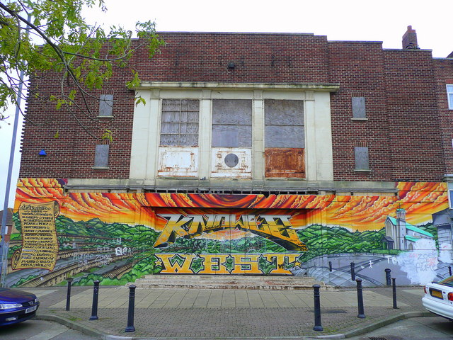
Filwood cinema This art deco building stands as a testimony to how the suburbs of South Bristol have changed in the 50+ years since this building was in its prime.
At least the local graffiti artist has made something of the blank canvas.
Filwood cinema
This art deco building stands as a testimony to how the suburbs of South Bristol have changed in the 50+ years since this building was in its prime. At least the local graffiti artist has made something of the blank canvas.
Church of Christ the King, Filwood Park A Roman Catholic church built in the optimistic early 1950's, like most of this southern suburb of Bristol.
Church of Christ the King, Filwood Park
A Roman Catholic church built in the optimistic early 1950's, like most of this southern suburb of Bristol.
Church of Christ the King, Filwood Park A Catholic church built in 1952, viewed from Filwood Broadway.
Church of Christ the King, Filwood Park
A Catholic church built in 1952, viewed from Filwood Broadway.
Shops in Filwood Broadway Speaks for itself, really.
Shops in Filwood Broadway
Speaks for itself, really.
Filwood Broadway; half term Kids congregating outside the shops the way they do and always have done.
Filwood Broadway; half term
Kids congregating outside the shops the way they do and always have done.
Filwood Park Library At the southern end of Filwood Park Broadway.
Filwood Park Library
At the southern end of Filwood Park Broadway.
Action Centre Formerly known as Whitchurch Sports Centre, this was originally Whitchurch Airport. The angled roofing betrays its history as Bristol's primary airport since it was opened in 1930. Many covert flights involved Whitchurch during the Second World War, particularly to neutral Portugal.
Action Centre
Formerly known as Whitchurch Sports Centre, this was originally Whitchurch Airport. The angled roofing betrays its history as Bristol's primary airport since it was opened in 1930. Many covert flights involved Whitchurch during the Second World War, particularly to neutral Portugal.
Stockwood Open Space Path from Stockwood Road to Brislington.
Stockwood Open Space
Path from Stockwood Road to Brislington.
Parish Church, Whitchurch, Bristol
Whitchurch railway path, Bristol Designated as the "Whitchurch Way" - a cycle route which extends northwards to Arnos Vale and the River Avon as far as Temple Meads.
Whitchurch railway path, Bristol
Designated as the "Whitchurch Way" - a cycle route which extends northwards to Arnos Vale and the River Avon as far as Temple Meads.
Estate agents , Whitchurch
Knowle Golf Course, Bristol
Oasis Academy John Williams The Oasis Academy was opened in September 2008 on the site of the old Hengrove School and is now known as "Oasis Academy John Williams".
Oasis Academy John Williams
The Oasis Academy was opened in September 2008 on the site of the old Hengrove School and is now known as "Oasis Academy John Williams".
Perry Court Junior & Infant School Seen from Great Hayles Road
Perry Court Junior & Infant School
Seen from Great Hayles Road
All-weather pitches at the South Bristol Sports Centre
Show me another place!

Mowberry Road Open Space is located at Grid Ref: ST6169 (Lat: 51.422286, Lng: -2.5605808)

Unitary Authority: Bristol

Police Authority: Avon and Somerset

What 3 Words

///choice.lied.surely. Near Whitchurch, Somerset

Related Wikis

Petherton Resource Centre

Petherton Resource Centre is a centre for community mental health services in South Bristol, United Kingdom. It is managed by Avon and Wiltshire Mental...

Oasis Academy John Williams

Oasis Academy John Williams is a secondary school with an academy status in the Hengrove district of Bristol, England. Opened in 2008, it is run by Oasis...

Counterslip Baptist Church

Counterslip Baptist Church is a church located in south Bristol, England. It has been located on its current site on the Wells Road since the 1950s having...

South Bristol, England

South Bristol is the part of Bristol, England south of the Bristol Avon. It is almost entirely made up of the areas of the city historically in Somerset...

Nearby Amenities

Located within 500m of 51.422286,-2.5605808
Turning Circle
Lat/Long: 51.4251148/-2.5646065
Turning Circle
Lat/Long: 51.4245681/-2.5641304
Turning Circle
Lat/Long: 51.4216712/-2.566942
Turning Circle
Lat/Long: 51.423336/-2.5646655
Bus Stop
Beryl Grove
Naptan AtcoCode: 0100053320
Naptan Bearing: W
Naptan CommonName: Beryl Grove
Naptan Crossing: Wells Road
Naptan NaptanCode: bstjtjg
Naptan PlusbusZoneRef: BRSTLTM
Naptan Street: West Town Lane
Naptan Verified: no
Source: naptan_import
Lat/Long: 51.4260362/-2.5623886
Bus Stop
Sturminster Road (B)
Naptan AtcoCode: 0100BRA10175
Naptan Bearing: E
Naptan CommonName: Sturminster Road b
Naptan Crossing: Sturminster Road
Naptan Landmark: Imperial Sports Ground
Naptan NaptanCode: bstjwjw
Naptan PlusbusZoneRef: BRSTLTM
Naptan Street: West Town Lane
Naptan Verified: no
Source: naptan_import
Lat/Long: 51.4263541/-2.5579624
Bus Stop
Sturminster Road (A)
Naptan AtcoCode: 0100BRA10176
Naptan Bearing: W
Naptan CommonName: Sturminster Road a
Naptan Crossing: Sturminster Road
Naptan Landmark: Imperial Sports Ground
Naptan NaptanCode: bstjwjt
Naptan PlusbusZoneRef: BRSTLTM
Naptan Street: West Town Lane
Naptan Verified: no
Source: naptan_import
Lat/Long: 51.4262101/-2.5579894
Bus Stop
Clive Road
Bench: yes
Bin: yes
Mapillary: 418022429237739
Naptan AtcoCode: 0100BRA10342
Naptan Bearing: S
Naptan CommonName: Clive Road
Naptan Crossing: Clive Road
Naptan NaptanCode: bstjtjp
Naptan PlusbusZoneRef: BRSTLTM
Naptan Street: Wells Road
Naptan Verified: no
Public Transport: platform
Shelter: yes
Source: naptan_import
Survey Date: 2021-06-16
Lat/Long: 51.4228627/-2.5622634
Bus Stop
Counterslip Gardens
Bench: no
Bin: no
Lit: yes
Mapillary: 508233550595741
Naptan AtcoCode: 0100BRA10343
Naptan Bearing: SW
Naptan CommonName: New Fosseway Road
Naptan Crossing: New Fosseway Road
Naptan Landmark: New Fosseway School
Naptan NaptanCode: bstjwap
Naptan PlusbusZoneRef: BRSTLTM
Naptan Street: Wells Road
Naptan Verified: no
Public Transport: platform
Shelter: no
Source: naptan_import
Survey Date: 2021-06-16
Tactile Paving: yes
Lat/Long: 51.4179084/-2.5603331
Bus Stop
Clive Road
Bench: yes
Bin: yes
Mapillary: 975687783000541
Naptan AtcoCode: 0100BRA10354
Naptan Bearing: N
Naptan CommonName: Clive Road
Naptan Crossing: Clive Road
Naptan NaptanCode: bstjtjm
Naptan PlusbusZoneRef: BRSTLTM
Naptan Street: Wells Road
Naptan Verified: no
Public Transport: platform
Shelter: yes
Source: naptan_import
Survey Date: 2021-06-16
Lat/Long: 51.4225206/-2.5623455
Bus Stop
Morden Walk
Bench: no
Bin: no
Bus: yes
Mapillary: 223744155824145
Naptan AtcoCode: 0100BRA10413
Naptan Bearing: SW
Naptan CommonName: Morden Walk
Naptan Crossing: Morden Walk
Naptan NaptanCode: bstmajm
Naptan PlusbusZoneRef: BRSTLTM
Naptan Street: Sturminster Road
Naptan Verified: no
Public Transport: platform
Shelter: no
Source: naptan_import
Survey Date: 2020-07-12
Lat/Long: 51.4209192/-2.554351
Bus Stop
Morden Walk
Bench: yes
Bin: no
Bus: yes
Mapillary: 512587283252181
Naptan AtcoCode: 0100BRA10414
Naptan Bearing: N
Naptan CommonName: Morden Walk
Naptan Crossing: Morden Walk
Naptan NaptanCode: bstmagw
Naptan PlusbusZoneRef: BRSTLTM
Naptan Street: Sturminster Road
Naptan Verified: no
Public Transport: platform
Shelter: yes
Source: naptan_import
Survey Date: 2020-07-12
Lat/Long: 51.4212444/-2.5546498
Bus Stop
Manston Close
Bench: yes
Bin: no
Mapillary: 304665411151383
Naptan AtcoCode: 0100BRA10415
Naptan Bearing: N
Naptan CommonName: Manston Close
Naptan Crossing: Durweston Walk
Naptan NaptanCode: bstmadj
Naptan PlusbusZoneRef: BRSTLTM
Naptan Street: Sturminster Road
Naptan Verified: no
Public Transport: platform
Shelter: yes
Source: naptan_import
Survey Date: 2020-07-12
Lat/Long: 51.4228745/-2.5560071
Bus Stop
Manston Close
Bench: no
Bin: no
Mapillary: 1858184517671539
Naptan AtcoCode: 0100BRA10417
Naptan Bearing: S
Naptan CommonName: Manston Close
Naptan Crossing: Durweston Walk
Naptan NaptanCode: bstmadp
Naptan PlusbusZoneRef: BRSTLTM
Naptan Street: Sturminster Road
Naptan Verified: no
Public Transport: platform
Shelter: no
Source: naptan_import
Survey Date: 2020-07-12
Lat/Long: 51.4227409/-2.5557466
Bus Stop
Sturminster Road (C)
Bench: yes
Bin: yes
Mapillary: 459466111781960
Naptan AtcoCode: 0100BRA10418
Naptan Bearing: S
Naptan CommonName: Sturminster Road c
Naptan Crossing: West Town Lane
Naptan NaptanCode: bstjwpj
Naptan PlusbusZoneRef: BRSTLTM
Naptan Street: Sturminster Road
Naptan Verified: no
Passenger Information Display: yes
Public Transport: platform
Shelter: yes
Source: naptan_import
Survey Date: 2020-07-12
Lat/Long: 51.4258276/-2.5571073
Bus Stop
David's Road
Naptan AtcoCode: 0100BRA10419
Naptan Bearing: N
Naptan CommonName: David's Road
Naptan Crossing: David's Road
Naptan NaptanCode: bstjwtp
Naptan PlusbusZoneRef: BRSTLTM
Naptan Street: Hazlebury Road
Naptan Verified: no
Source: naptan_import
Lat/Long: 51.4190151/-2.5564061
Bus Stop
Hazelbury Road
Naptan AtcoCode: 0100BRA10421
Naptan Bearing: N
Naptan CommonName: Hazelbury Road a
Naptan NaptanCode: bstjwmt
Naptan PlusbusZoneRef: BRSTLTM
Naptan Street: Hazelbury Road
Naptan Verified: no
Source: naptan_import
Lat/Long: 51.4213661/-2.557427
Bus Stop
Hazelbury Road
Naptan AtcoCode: 0100BRA10423
Naptan Bearing: N
Naptan CommonName: Hazelbury Road b
Naptan NaptanCode: bstjwjp
Naptan PlusbusZoneRef: BRSTLTM
Naptan Street: Hazelbury Road
Naptan Verified: no
Source: naptan_import
Lat/Long: 51.4247318/-2.5587481
Barrier: entrance
Lat/Long: 51.4227873/-2.5566891
Traffic Signals
Lat/Long: 51.4260517/-2.5631643
Barrier: cycle_barrier
Lat/Long: 51.4228872/-2.5541175
Barrier: cycle_barrier
Lat/Long: 51.4229675/-2.5542067
Traffic Calming: island
Lat/Long: 51.4262507/-2.5587514
Crossing
Crossing: uncontrolled
Crossing Ref: zebra
Lat/Long: 51.4262684/-2.5574252
Traffic Signals
Lat/Long: 51.4260092/-2.5636164
Post Box
Post Box Type: pillar
Ref: BS14 149
Royal Cypher: EIIR
Royal Cypher Wikidata: Q33102113
Lat/Long: 51.4219517/-2.561712
Post Box
Post Box Type: lamp
Ref: BS14 441
Royal Cypher: EIIR
Royal Cypher Wikidata: Q33102113
Lat/Long: 51.4225419/-2.5653595
Post Box
Post Box Type: pillar
Ref: BS14 159
Royal Cypher: GR
Royal Cypher Wikidata: Q33102273
Lat/Long: 51.4255788/-2.5634579
Traffic Signals
Button Operated: yes
Crossing: traffic_signals
Crossing Ref: puffin
Tactile Paving: yes
Traffic Signals Vibration: no
Lat/Long: 51.4214154/-2.5615798
Speed Camera
Lat/Long: 51.4263327/-2.5634794
School
Bush Residential Resource Centre
Addr City: Bristol
Addr Housenumber: 12a
Addr Postcode: BS14 9LN
Addr Street: New Fosseway Road
Addr Suburb: Hengrove
Fhrs Id: 310421
Source Addr: FHRS Open Data
Lat/Long: 51.4179971/-2.5624775
Post Box
Collection Times: Mo-Fr 09:00; Sa 07:00
Note: Rare Edward Vlll pillar box
Operator: Royal Mail
Post Box Type: pillar
Ref: BS14 160
Royal Cypher: EVIIIR
Royal Cypher Wikidata: Q33102195
Lat/Long: 51.4256852/-2.5588357
Power: substation
Lat/Long: 51.426117/-2.5577792
Power: substation
Substation: minor_distribution
Lat/Long: 51.4239428/-2.5609453
Turning Circle
Lat/Long: 51.4249066/-2.5609908
Barrier: swing_gate
Bicycle: yes
Foot: yes
Motor Vehicle: private
Lat/Long: 51.4207863/-2.5569821
Turning Circle
Lat/Long: 51.4212239/-2.5586173
Traffic Signals
Lat/Long: 51.4261728/-2.5634266
Traffic Signals
Lat/Long: 51.4258897/-2.563377
Leisure: playground
Lat/Long: 51.4238815/-2.556092
Colour: green
Height: 1
Man Made: street_cabinet
Operator: Openreach
Ref: SSSOU 21
Street Cabinet: telephone
Utility: telecom
Lat/Long: 51.4262057/-2.5636249
Colour: green
Description: FTTC distribution
Height: 1
Man Made: street_cabinet
Operator: Openreach
Operator Wikidata: Q7096543
Utility: telecom
Lat/Long: 51.426098/-2.5636126
Street Lamp
Ref: 65
Lat/Long: 51.4260807/-2.5636163
Addr City: Bristol
Addr Housenumber: 203
Addr Street: Hazelbury Road
Lat/Long: 51.4189/-2.556009
Addr City: Bristol
Addr Housenumber: 1
Addr Street: Hazelbury Road
Lat/Long: 51.4257583/-2.5586974
Addr City: Bristol
Addr Housenumber: 47
Addr Street: Hazelbury Road
Lat/Long: 51.4239105/-2.5581784
Addr City: Bristol
Addr Housenumber: 107
Addr Street: Hazelbury Road
Lat/Long: 51.4215351/-2.557177
Addr City: Bristol
Addr Housenumber: 109
Addr Street: Hazelbury Road
Lat/Long: 51.4214582/-2.5571325
Cafe
Lat/Long: 51.4263053/-2.5593333
Indoor Play: sensory_room
Leisure: indoor_play
Lat/Long: 51.426442/-2.5590527
Direction: 220
Generator Method: photovoltaic
Generator Output Electricity: yes
Generator Solar Modules: 13
Generator Source: solar
Generator Type: solar_photovoltaic_panel
Location: roof
Power: generator
Lat/Long: 51.4236434/-2.5610522
Direction: 150
Generator Method: photovoltaic
Generator Output Electricity: yes
Generator Solar Modules: 38
Generator Source: solar
Generator Type: solar_photovoltaic_panel
Location: roof
Power: generator
Lat/Long: 51.4261296/-2.559664
Direction: 150
Generator Method: photovoltaic
Generator Output Electricity: yes
Generator Solar Modules: 21
Generator Source: solar
Generator Type: solar_photovoltaic_panel
Location: roof
Power: generator
Lat/Long: 51.4262137/-2.5594206
Direction: 150
Generator Method: photovoltaic
Generator Output Electricity: yes
Generator Solar Modules: 19
Generator Source: solar
Generator Type: solar_photovoltaic_panel
Location: roof
Power: generator
Lat/Long: 51.4262996/-2.5592512
Direction: 170
Generator Method: photovoltaic
Generator Output Electricity: yes
Generator Solar Modules: 6
Generator Source: solar
Generator Type: solar_photovoltaic_panel
Location: roof
Power: generator
Lat/Long: 51.4262996/-2.5591533
Traffic Calming: island
Lat/Long: 51.4261493/-2.5571185
Direction: 170
Generator Method: photovoltaic
Generator Output Electricity: yes
Generator Source: solar
Generator Type: solar_photovoltaic_panel
Location: roof
Power: generator
Lat/Long: 51.426372/-2.5589351
Direction: 170
Generator Method: photovoltaic
Generator Output Electricity: yes
Generator Source: solar
Generator Type: solar_photovoltaic_panel
Location: roof
Power: generator
Lat/Long: 51.4264034/-2.5586998
Direction: 120
Generator Method: photovoltaic
Generator Output Electricity: yes
Generator Solar Modules: 16
Generator Source: solar
Generator Type: solar_photovoltaic_panel
Location: roof
Power: generator
Lat/Long: 51.4240309/-2.5670155
Direction: 120
Generator Method: photovoltaic
Generator Output Electricity: yes
Generator Solar Modules: 8
Generator Source: solar
Generator Type: solar_photovoltaic_panel
Location: roof
Power: generator
Lat/Long: 51.424056/-2.5664372
Direction: 210
Generator Method: photovoltaic
Generator Output Electricity: yes
Generator Solar Modules: 4
Generator Source: solar
Generator Type: solar_photovoltaic_panel
Location: roof
Power: generator
Lat/Long: 51.4240378/-2.5665029
Direction: 210
Generator Method: photovoltaic
Generator Output Electricity: yes
Generator Solar Modules: 12
Generator Source: solar
Generator Type: solar_photovoltaic_panel
Location: roof
Power: generator
Lat/Long: 51.4240795/-2.5665534
Direction: 160
Generator Method: photovoltaic
Generator Output Electricity: yes
Generator Solar Modules: 11
Generator Source: solar
Generator Type: solar_photovoltaic_panel
Location: roof
Power: generator
Lat/Long: 51.4252164/-2.5654792
Generator Method: photovoltaic
Generator Output Electricity: yes
Generator Source: solar
Generator Type: solar_photovoltaic_panel
Location: roof
Power: generator
Lat/Long: 51.4227709/-2.5609351
Generator Method: photovoltaic
Generator Output Electricity: yes
Generator Source: solar
Generator Type: solar_photovoltaic_panel
Location: roof
Power: generator
Lat/Long: 51.4229265/-2.5612355
Generator Method: photovoltaic
Generator Output Electricity: yes
Generator Source: solar
Generator Type: solar_photovoltaic_panel
Location: roof
Power: generator
Lat/Long: 51.4260427/-2.5639613
Generator Method: photovoltaic
Generator Output Electricity: yes
Generator Source: solar
Generator Type: solar_photovoltaic_panel
Location: roof
Power: generator
Lat/Long: 51.42241/-2.55443
Street Lamp
Lat/Long: 51.4211492/-2.5543148
Generator Method: photovoltaic
Generator Output Electricity: yes
Generator Source: solar
Generator Type: solar_photovoltaic_panel
Location: roof
Power: generator
Lat/Long: 51.42068/-2.5546219
The data included in this document is from www.openstreetmap.org. The data is made available under ODbL.

Have you been to Mowberry Road Open Space?

Leave your review of Mowberry Road Open Space below (or comments, questions and feedback).