Bells Moor

Downs, Moorland in Northumberland

England

Bells Moor

Minor road near Kielder
Minor road near Kielder Credit: Steven Brown

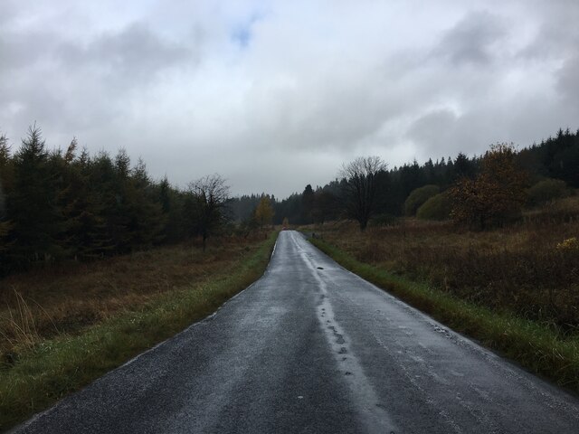
Bells Moor is a picturesque area located in Northumberland, England. Situated in the northern part of the county, it is characterized by its vast expanse of downs and moorland. Spanning across several square kilometers, this natural landscape offers visitors a unique and breathtaking experience.

The moorland of Bells Moor is known for its rolling hills, heather-covered terrain, and scattered patches of woodland. The area is home to a diverse range of flora and fauna, including a variety of bird species, small mammals, and rare plant species. It is a haven for nature enthusiasts, bird watchers, and hikers who can explore the numerous walking trails that crisscross the moor.

The downs of Bells Moor are equally captivating, featuring undulating grasslands and panoramic views of the surrounding countryside. These open spaces provide ample opportunities for outdoor activities such as picnicking, kite flying, and even horse riding. The downs are also a popular spot for local farmers to graze their livestock.

Bells Moor offers a tranquil and peaceful environment, with its unspoiled natural beauty and remote location. Away from the hustle and bustle of urban life, visitors can enjoy the serenity and solitude that this area provides. The changing seasons further enhance its charm, as the moorland transforms from vibrant purple hues in the summer to golden tones in the autumn.

Overall, Bells Moor in Northumberland is a hidden gem, beloved by locals and treasured by those who seek a respite in the heart of nature. Its diverse landscapes, rich wildlife, and stunning scenery make it a must-visit destination for anyone seeking to immerse themselves in the beauty of Northumberland's countryside.

If you have any feedback on the listing, please let us know in the comments section below.

Bells Moor Images

Images are sourced within 2km of 55.256225/-2.6272358 or Grid Reference NY6095. Thanks to Geograph Open Source API. All images are credited.

Minor road near Kielder
Forestry road near Deadwater
Minor road towards Saughtree
Lime Kilns from Thorlieshope Lime Works, north of Kielder: 2022 See   for 2006 view. 

The old quarry was directly behind the works, and had sidings off the Border Counties Railway which ran up the Dale in front of the works. A second quarry at Fairloans was developed less than a mile to the south, to supply limestone to the works. Thorlieshope was producing lime from around 1870 to 1923, when the works are described as disused.

For site in 1899 see OS map <span class="nowrap"><a title="https://maps.nls.uk/view/101027016" rel="nofollow ugc noopener" href="https://maps.nls.uk/view/101027016">Link</a><img style="margin-left:2px;" alt="External link" title="External link - shift click to open in new window" src="https://s1.geograph.org.uk/img/external.png" width="10" height="10"/></span>
Lime Kilns from Thorlieshope Lime Works, north of Kielder: 2022
See for 2006 view. The old quarry was directly behind the works, and had sidings off the Border Counties Railway which ran up the Dale in front of the works. A second quarry at Fairloans was developed less than a mile to the south, to supply limestone to the works. Thorlieshope was producing lime from around 1870 to 1923, when the works are described as disused. For site in 1899 see OS map LinkExternal link
Are these old Lime Kilns? Just before the English Scottish border on what is essentially a logging road that leads to Kielder Castle we came across these two structures. They might be lime kilns.  The logging road was very busy with empty lorries travelling quickly towards the forest and loaded lorries travelling almost as fast away from the forest.
Are these old Lime Kilns?
Just before the English Scottish border on what is essentially a logging road that leads to Kielder Castle we came across these two structures. They might be lime kilns. The logging road was very busy with empty lorries travelling quickly towards the forest and loaded lorries travelling almost as fast away from the forest.
Building remains at Fairloans Quarry The remains of a building at Fairloans Quarry.  The quarry yielded sandstone, later used in buildings and monuments in Edinburgh.  The stone was 'capable of a high polish' and was 'greatly used for monumental purposes'.  Deadwater Fell and its summit radar station loom large in the background.

This photograph was taken during the Coronavirus (COVID-19) pandemic of 2020.
Building remains at Fairloans Quarry
The remains of a building at Fairloans Quarry. The quarry yielded sandstone, later used in buildings and monuments in Edinburgh. The stone was 'capable of a high polish' and was 'greatly used for monumental purposes'. Deadwater Fell and its summit radar station loom large in the background. This photograph was taken during the Coronavirus (COVID-19) pandemic of 2020.
Forest road end, Kittythirst A group about to set off up Peel Fell. This was a celebration of the tenth anniversary of the first traverse of Scotland's East-West watershed by Dave Hewitt in 1987.  Peel Fell is where the watershed finally leaves the border and heads northwestwards into Scotland.

Fourteen years on the bare patch was once again covered in trees. <a href="https://www.geograph.org.uk/photo/2732973">NY6096 : Forest Track near Kittyhirst</a>
Forest road end, Kittythirst
A group about to set off up Peel Fell. This was a celebration of the tenth anniversary of the first traverse of Scotland's East-West watershed by Dave Hewitt in 1987. Peel Fell is where the watershed finally leaves the border and heads northwestwards into Scotland. Fourteen years on the bare patch was once again covered in trees. NY6096 : Forest Track near Kittyhirst
'The Forks' Rally stage 13 Nearing the end of the stage, and back in England.
'The Forks' Rally stage 13
Nearing the end of the stage, and back in England.
Forest road on the slopes of Deadwater Fell Looking down a section of forest road which provides a relatively easy route to the summit of the Fell. Clearfell to the right.
Forest road on the slopes of Deadwater Fell
Looking down a section of forest road which provides a relatively easy route to the summit of the Fell. Clearfell to the right.
Kielder Forest A view of a clearfelled area within Kielder Forest, looking back down the track walked, en route to Deadwater Fell.
Kielder Forest
A view of a clearfelled area within Kielder Forest, looking back down the track walked, en route to Deadwater Fell.
Snowy Plantation Within the Kielder Forest, en route to Deadwater Fell.
Snowy Plantation
Within the Kielder Forest, en route to Deadwater Fell.
Opening out The track to Deadwater Fell leaving the confines of the mature plantation to run alongside a clearfelled area.
Opening out
The track to Deadwater Fell leaving the confines of the mature plantation to run alongside a clearfelled area.
Approaching the border A damp section of the trackbed of the former Border Counties Railway approaching the English border near Deadwater.

This photograph was taken during the Coronavirus (COVID-19) pandemic of 2020.
Approaching the border
A damp section of the trackbed of the former Border Counties Railway approaching the English border near Deadwater. This photograph was taken during the Coronavirus (COVID-19) pandemic of 2020.
Bathing house remains near Deadwater Captured as the sun lowered in the November afternoon sky, the remains of an early 19th century bathing house can be found in a small clearing in a patch of forestry near Deadwater.  Further details about the bathing house can be found at <a title="https://www.geograph.org.uk/photo/4134098" href="https://www.geograph.org.uk/photo/4134098">Link</a>

This photograph was taken during the Coronavirus (COVID-19) pandemic of 2020.
Bathing house remains near Deadwater
Captured as the sun lowered in the November afternoon sky, the remains of an early 19th century bathing house can be found in a small clearing in a patch of forestry near Deadwater. Further details about the bathing house can be found at Link This photograph was taken during the Coronavirus (COVID-19) pandemic of 2020.
Fairloans Fairloans lies just inside Scotland; it's seen here from the minor road north-west of Kielder and was unoccupied at the time the photograph was taken. The nearer green track was the route of a now lost railway.
Fairloans
Fairloans lies just inside Scotland; it's seen here from the minor road north-west of Kielder and was unoccupied at the time the photograph was taken. The nearer green track was the route of a now lost railway.
Disused lime kilns at Fairloans With the trackbed of the former Border Counties Railway in the foreground.
Disused lime kilns at Fairloans
With the trackbed of the former Border Counties Railway in the foreground.
Trackbed of former Border Counties Railway Disappears into forest.
Trackbed of former Border Counties Railway
Disappears into forest.
Sheepfold by March Sike over Bells Burn The name March Sike might indicate that this was a former course of the England - Scotland Border, although that now follows Bells Burn.
Sheepfold by March Sike over Bells Burn
The name March Sike might indicate that this was a former course of the England - Scotland Border, although that now follows Bells Burn.
Show me another place!

Bells Moor is located at Grid Ref: NY6095 (Lat: 55.256225, Lng: -2.6272358)

Unitary Authority: Northumberland

Police Authority: Northumbria

What 3 Words

///monitors.bless.disengage. Near Hawick, Scottish Borders

Nearby Locations

Bells Moor

Related Wikis

Deadwater, Northumberland

Deadwater is a small settlement in Northumberland, England, about 3 miles (5 km) north west of Kielder, Northumberland, on the English side of the border...

Deadwater railway station

Deadwater railway station is a closed railway station situated on the border between England and Scotland at the head of the North Tyne River. The station...

Kielder Forest Star Camp

The Kielder Forest Star Camp is an annual star party held each autumn and spring in Kielder Forest. The five night event is based on the Kielder Campsite...

Kielder railway station

Kielder railway station is a closed railway station that served the village hamlet of Kielder, Northumberland. == History == Kielder railway station was...

Nearby Amenities

Located within 500m of 55.256225,-2.6272358
Blackhope
Place: locality
Lat/Long: 55.2530113/-2.632567
Bells Moor
Place: locality
Lat/Long: 55.2576899/-2.6325075
The data included in this document is from www.openstreetmap.org. The data is made available under ODbL.

Have you been to Bells Moor?

Leave your review of Bells Moor below (or comments, questions and feedback).