Glebe Strip

Downs, Moorland in Roxburghshire

Scotland

Glebe Strip

Farm access at Bedrule
Farm access at Bedrule Credit: Alan Reid

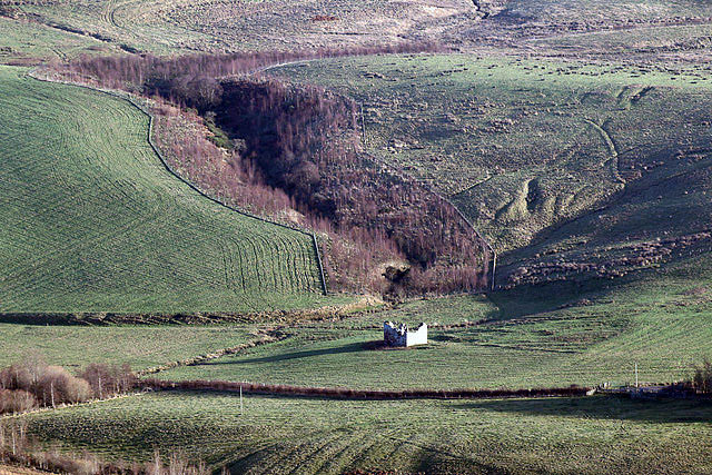
The Glebe Strip, located in Roxburghshire, Scotland, is a picturesque area that encompasses both downs and moorland. Stretching across approximately five miles, it offers a diverse landscape that attracts nature enthusiasts and outdoor adventurers alike.

The downs, characterized by rolling hills and expansive grasslands, provide a serene setting for walking and hiking. Visitors can enjoy panoramic views of the surrounding countryside and take in the tranquil atmosphere. The gentle slopes of the downs are accessible to all levels of walkers, making it an ideal location for a leisurely stroll or a family outing.

In contrast, the moorland in Glebe Strip offers a more rugged and wild terrain. Blanketed with heather, the moors provide a unique and vibrant landscape, especially when in bloom during the summer months. This area is a haven for birdwatchers, as it is home to several species of birds, including merlins, short-eared owls, and golden plovers.

The Glebe Strip is also a designated nature reserve, ensuring the preservation of its diverse flora and fauna. Rare orchids and wildflowers can be found scattered throughout the area, adding a splash of color to the otherwise green landscape. Additionally, the moorland serves as a habitat for various wildlife, such as red deer, mountain hares, and grouse.

Overall, the Glebe Strip in Roxburghshire offers a harmonious blend of downs and moorland, providing visitors with an opportunity to explore and appreciate the natural beauty of the Scottish countryside. Whether it be a tranquil walk along the downs or an adventurous hike through the moorland, this area has something to offer for every nature lover.

If you have any feedback on the listing, please let us know in the comments section below.

Glebe Strip Images

Images are sourced within 2km of 55.450744/-2.6337504 or Grid Reference NT6017. Thanks to Geograph Open Source API. All images are credited.

Farm access at Bedrule
New house at Bedrule
Fulton Tower This telephoto shot of the ruined 16th century tower house was taken from the summit area of Rubers Law. For a closer view of the tower, see <a href="https://www.geograph.org.uk/photo/255052">NT6015 : The remains of Fulton Tower</a>.
Fulton Tower
This telephoto shot of the ruined 16th century tower house was taken from the summit area of Rubers Law. For a closer view of the tower, see NT6015 : The remains of Fulton Tower.
War memorial, Bedrule At the road junction south of the village.
War memorial, Bedrule
At the road junction south of the village.
Bedrule Village Hall A spacious hall for this small village, though I expect it caters for people from a wide area in these scattered communities. Rubers Law is in the background.
Bedrule Village Hall
A spacious hall for this small village, though I expect it caters for people from a wide area in these scattered communities. Rubers Law is in the background.
Minor road heading towards Huntly Hill Looking south-eastward.
Minor road heading towards Huntly Hill
Looking south-eastward.
Minor road approaching Fulton Farm and Huntly Hill Looking southward.
Minor road approaching Fulton Farm and Huntly Hill
Looking southward.
Field containing the remains of Fulton Tower Looking north-eastward
Field containing the remains of Fulton Tower
Looking north-eastward
Minor road enclosed between hedge and woodland near to Monks Pond Looking south-westward.
Minor road enclosed between hedge and woodland near to Monks Pond
Looking south-westward.
Minor road near Bedrule on a frosty December morning Looking north-eastward.
Minor road near Bedrule on a frosty December morning
Looking north-eastward.
Borders  Abbeys  Way  on  Black  Law Across this rough section then drop down toward Bedrule
Borders Abbeys Way on Black Law
Across this rough section then drop down toward Bedrule
Descending  from  Black  Law  toward  Bedrule An excellent view of the extinct volcano Rubers Law
Descending from Black Law toward Bedrule
An excellent view of the extinct volcano Rubers Law
Borders  Abbeys  Way  toward  Bedrule The B A Way follows this wall along to a track going right to the road at Bedrule
Borders Abbeys Way toward Bedrule
The B A Way follows this wall along to a track going right to the road at Bedrule
Road  into  Bedrule
Road into Bedrule
Road  junction  at  War  Memorial  near  Bedrule Borders Abbeys Way goes right here down to the river, Rule Water
Road junction at War Memorial near Bedrule
Borders Abbeys Way goes right here down to the river, Rule Water
War  Memorial  Bedrule Commemorating both world wars. The B A Way turns at this junction
War Memorial Bedrule
Commemorating both world wars. The B A Way turns at this junction
Fulton Tower The remains of a 16th century tower house.
Fulton Tower
The remains of a 16th century tower house.
Futon Farm In the valley of the Rule Water.
Futon Farm
In the valley of the Rule Water.
Show me another place!

Glebe Strip is located at Grid Ref: NT6017 (Lat: 55.450744, Lng: -2.6337504)

Unitary Authority: The Scottish Borders

Police Authority: The Lothians and Scottish Borders

What 3 Words

///lanes.workbook.emails. Near Jedburgh, Scottish Borders

Nearby Locations

Glebe Strip Sourlees Strip

Related Wikis

Bedrule

Bedrule (Scottish Gaelic: Ruail Bheathaig) is a hamlet and civil parish in the historic county of Roxburghshire in the Scottish Borders area of Scotland...
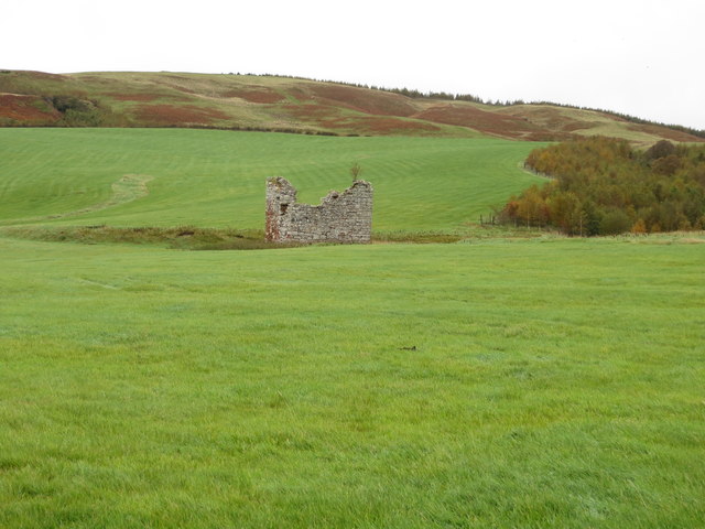
Bedrule Castle

Bedrule Castle is a ruined 13th-century castle in the Rule Valley, in the Scottish Borders area of Scotland. The castle was built in the 13th century by...
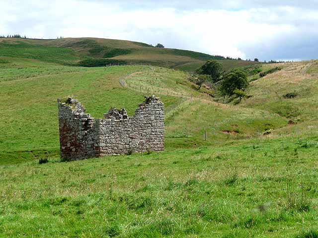
Fulton Tower

Fulton Tower is a ruined 16th century tower house, about 4.5 miles (7.2 km) south west of Jedburgh, Scottish Borders, Scotland, and about 2 miles (3.2...

Spittal-on-Rule

Spittal-on-Rule is a farm in the council area of Scottish Borders in Scotland. As the name suggests it is situated on the river Rule Water, and the Spittal...

Nearby Amenities

Located within 500m of 55.450744,-2.6337504
Bedrule
Name Gd: Riaghal Beathag
Name Sco: Badrule
Place: village
Wikidata: Q4879425
Wikipedia: en:Bedrule
Lat/Long: 55.45412/-2.6346462
Noexit: yes
Lat/Long: 55.4524954/-2.6359817
Bedrule Castle (Site of)
Historic: archaeological_site
Lat/Long: 55.4547186/-2.6369249
War Memorial
Historic: memorial
Lat/Long: 55.4520489/-2.6332928
Barrier: stile
Stile: stepover
Lat/Long: 55.4535484/-2.6344584
Telephone
Booth: K6
Covered: booth
Operator: BT
Phone: +44 1450 870 211
Lat/Long: 55.4540144/-2.6344398
Post Box
Operator: Royal Mail
Post Box Type: wall
Ref: TD9 32
Lat/Long: 55.4540965/-2.6343901
Addr Housenumber: 4
Lat/Long: 55.4548191/-2.6340426
Addr Housenumber: 3
Lat/Long: 55.4548813/-2.6340227
Addr Housenumber: 2
Lat/Long: 55.4549313/-2.6340044
Addr Housenumber: 1
Lat/Long: 55.4550208/-2.6339712
Power: pole
Lat/Long: 55.4467258/-2.6327158
Power: pole
Lat/Long: 55.4474548/-2.6336397
Power: pole
Lat/Long: 55.4480379/-2.6343727
Power: pole
Lat/Long: 55.448637/-2.6351337
Power: pole
Lat/Long: 55.4494496/-2.6348181
Power: pole
Lat/Long: 55.4502868/-2.6344872
Power: pole
Lat/Long: 55.451108/-2.6341818
Power: pole
Lat/Long: 55.4519524/-2.6338459
Power: pole
Lat/Long: 55.4527635/-2.633543
Power: pole
Lat/Long: 55.4538041/-2.6343447
Power: pole
Lat/Long: 55.4546051/-2.6349759
Power: pole
Lat/Long: 55.4528761/-2.633006
Power: pole
Lat/Long: 55.4538243/-2.6329856
Power: pole
Lat/Long: 55.4546802/-2.6321788
Power: pole
Lat/Long: 55.4541923/-2.6310794
Power: pole
Lat/Long: 55.4531846/-2.6370291
Power: pole
Lat/Long: 55.454/-2.635609
Power: pole
Lat/Long: 55.4536522/-2.6362198
Power: pole
Lat/Long: 55.452704/-2.6378741
The data included in this document is from www.openstreetmap.org. The data is made available under ODbL.

Have you been to Glebe Strip?

Leave your review of Glebe Strip below (or comments, questions and feedback).