Compton Park

Downs, Moorland in Dorset

England

Compton Park

Signpost, Park House
Signpost, Park House Credit: Richard Webb

Compton Park is a picturesque natural reserve located in Dorset, England. Situated on the Downs, the park covers a vast area of moorland, offering visitors a unique opportunity to immerse themselves in the serene beauty of the countryside.

The park boasts an extensive network of walking trails, providing hikers and nature enthusiasts with an array of scenic routes to explore. These trails meander through rolling hills, offering breathtaking views of the surrounding landscape, including an impressive variety of flora and fauna. From vibrant wildflowers to rare bird species, Compton Park is a haven for wildlife lovers.

The park's moorland is characterized by its heathland vegetation, dominated by heather and gorse, creating a vibrant tapestry of colors throughout the year. This habitat also supports a diverse range of wildlife, including lizards, adders, and numerous species of butterflies.

Compton Park is also renowned for its historical significance. It houses several ancient burial mounds, which are believed to date back to the Bronze Age. These archaeological gems provide a fascinating glimpse into the area's rich cultural heritage.

Visitors to Compton Park can take advantage of the various amenities available, including picnic areas, designated camping spots, and visitor centers offering information about the park's history and ecology. In addition, the park hosts educational programs and guided tours, allowing visitors to deepen their understanding of the local environment.

Overall, Compton Park offers a serene and enchanting experience for nature lovers, history enthusiasts, and those seeking a peaceful retreat amidst the beauty of Dorset's countryside.

If you have any feedback on the listing, please let us know in the comments section below.

Compton Park Images

Images are sourced within 2km of 50.94713/-2.5841246 or Grid Reference ST5916. Thanks to Geograph Open Source API. All images are credited.

Signpost, Park House
Stubble near Bradford Abbas
Stallen and the A30, Dorset view NW to where the local road from Nether Compton meets the A30.
Stallen and the A30, Dorset
view NW to where the local road from Nether Compton meets the A30.
Farm Track near Nether Compton A very muddy track with no right of way leading due north from the minor road that joins the hamlet of Stallen with the small village of Nether Compton just east of Yeovil.
Farm Track near Nether Compton
A very muddy track with no right of way leading due north from the minor road that joins the hamlet of Stallen with the small village of Nether Compton just east of Yeovil.
House at Bedmill Farm The house is located on the opposite side of the Sherborne to Bradford Abbas road from the farm itself.
House at Bedmill Farm
The house is located on the opposite side of the Sherborne to Bradford Abbas road from the farm itself.
Gated House in Stallen Looks like quite a place.
Gated House in Stallen
Looks like quite a place.
Stallen Postbox I guess "I'm just popping out to post a letter" wouldn't be much of an excuse in this house.
Stallen Postbox
I guess "I'm just popping out to post a letter" wouldn't be much of an excuse in this house.
Tuckers Barn, Stallen Looks like quite a barn conversion.
Tuckers Barn, Stallen
Looks like quite a barn conversion.
The old gateway, Stallen As far as I could see there is a small orchard behind this gate but I have been informed that it is the gateway to the Congregational Burial Ground and was erected some time about the middle of the 18th century.

It has a grade II listing as detailed as at: <span class="nowrap"><a title="http://www.imagesofengland.org.uk/Details/Default.aspx?id=105616&mode=adv" rel="nofollow ugc noopener" href="http://www.imagesofengland.org.uk/Details/Default.aspx?id=105616&mode=adv">Link</a><img style="margin-left:2px;" alt="External link" title="External link - shift click to open in new window" src="https://s1.geograph.org.uk/img/external.png" width="10" height="10"/></span> and <span class="nowrap"><a title="http://list.english-heritage.org.uk/resultsingle.aspx?uid=1154091" rel="nofollow ugc noopener" href="http://list.english-heritage.org.uk/resultsingle.aspx?uid=1154091">Link</a><img style="margin-left:2px;" alt="External link" title="External link - shift click to open in new window" src="https://s1.geograph.org.uk/img/external.png" width="10" height="10"/></span>

With thanks to Derek Harper and Ann Clark who both provided the additional information.
The old gateway, Stallen
As far as I could see there is a small orchard behind this gate but I have been informed that it is the gateway to the Congregational Burial Ground and was erected some time about the middle of the 18th century. It has a grade II listing as detailed as at: LinkExternal link and LinkExternal link With thanks to Derek Harper and Ann Clark who both provided the additional information.
Bottom of the lane to Tuckers Cross This Stallen lane is only suitable for 4 wheel drives and walkers.
Bottom of the lane to Tuckers Cross
This Stallen lane is only suitable for 4 wheel drives and walkers.
Grazing with a view These horses in have a fine view of Yeovil in the distance over the roofs of Nether Compton.
Grazing with a view
These horses in have a fine view of Yeovil in the distance over the roofs of Nether Compton.
Back down the lane This is the view back down the lane seen in <a href="https://www.geograph.org.uk/photo/1463821">ST6017 : Bottom of the lane to Tuckers Cross</a>.
Back down the lane
This is the view back down the lane seen in ST6017 : Bottom of the lane to Tuckers Cross.
Gore Lane The muddy track shown fording the Trent Brook in <a href="https://www.geograph.org.uk/photo/1555658">ST5916 : Trent Brook</a> climbs between damp ferns through a small wood towards Stallen.
Gore Lane
The muddy track shown fording the Trent Brook in ST5916 : Trent Brook climbs between damp ferns through a small wood towards Stallen.
Smelland's Lane From its junction with Gore Lane. What pretty names the green lanes have around here. But this is clearly an old route (between Over Compton - perhaps Yeovil - and Sherborne) from the sunken nature of the track in the sandstone. Above, on the right, is Munden's Copse.
Smelland's Lane
From its junction with Gore Lane. What pretty names the green lanes have around here. But this is clearly an old route (between Over Compton - perhaps Yeovil - and Sherborne) from the sunken nature of the track in the sandstone. Above, on the right, is Munden's Copse.
Cave near Stallen This cave on the north side of <a href="https://www.geograph.org.uk/photo/1555825">ST6016 : Smelland's Lane</a> exhibits stonework both in and out. Like Malcolm Balmer (see <span class="nowrap"><a title="http://www.dorsetcamera.co.uk/html/11_january_2009.html" rel="nofollow ugc noopener" href="http://www.dorsetcamera.co.uk/html/11_january_2009.html">Link</a><img style="margin-left:2px;" alt="External link" title="External link - shift click to open in new window" src="https://s1.geograph.org.uk/img/external.png" width="10" height="10"/></span> ) I have no idea what it was for.
Cave near Stallen
This cave on the north side of ST6016 : Smelland's Lane exhibits stonework both in and out. Like Malcolm Balmer (see LinkExternal link ) I have no idea what it was for.
Cave near Stallen (2) The interior of <a href="https://www.geograph.org.uk/photo/1555919">ST6016 : Cave near Stallen</a>, showing some of the masonry within.
Cave near Stallen (2)
The interior of ST6016 : Cave near Stallen, showing some of the masonry within.
Thatched cottage, Stallen The Old Forge is on the lane east of Nether Compton. Just along to the right is <a href="https://www.geograph.org.uk/photo/1463809">ST6016 : The old gateway, Stallen</a>.
Thatched cottage, Stallen
The Old Forge is on the lane east of Nether Compton. Just along to the right is ST6016 : The old gateway, Stallen.
Cottages at Stallen The twisting lane through Stallen passes a succession of buildings, although the hamlet seems to have no obvious visual focus.
Cottages at Stallen
The twisting lane through Stallen passes a succession of buildings, although the hamlet seems to have no obvious visual focus.
Show me another place!

Compton Park is located at Grid Ref: ST5916 (Lat: 50.94713, Lng: -2.5841246)

Unitary Authority: Dorset

Police Authority: Dorset

What 3 Words

///loser.dawn.clean. Near Yeovil, Somerset

Related Wikis

Over Compton

Over Compton is a village and civil parish in north west Dorset, England, situated in the Yeo valley 2 miles (3.2 km) east of Yeovil. In the 2011 census...

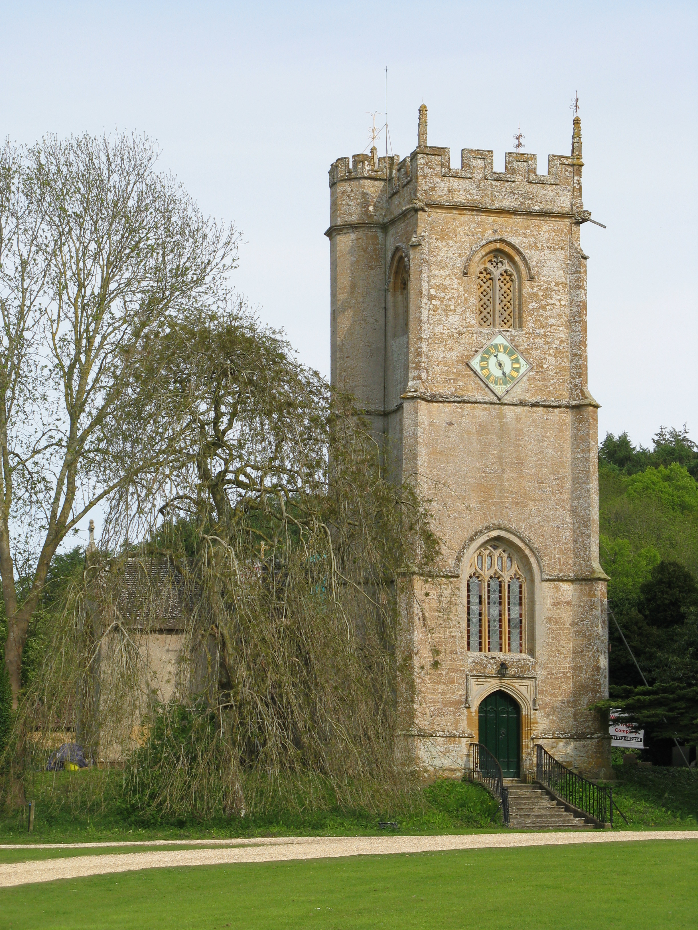
St Michael's Church, Over Compton

St Michael's Church is a Church of England church in Over Compton, Dorset, England. The church dates to the 15th-century, with later additions and restorations...

Babylon Hill

Babylon Hill (grid reference ST583162) in Dorset is a 2.2 hectare geological Site of Special Scientific Interest designated in 1977. It was also the site...

Battle of Babylon Hill

The battle of Babylon Hill was an indecisive skirmish that took place between Royalist and Parliamentarian forces near Yeovil, in South West England, on...

Nearby Amenities

Located within 500m of 50.94713,-2.5841246
Over Compton
Created By: Potlatch 0.8a
Place: village
Lat/Long: 50.9502795/-2.5848095
Power: tower
Source: bing
Lat/Long: 50.9448024/-2.5851555
Power: tower
Source: bing
Lat/Long: 50.946871/-2.5875715
Bus Stop
Forwards Garage
Bus: yes
Naptan AtcoCode: 1200DOB21236
Naptan Bearing: E
Naptan CommonName: Forwards Garage
Naptan Indicator: E-bound
Naptan NaptanCode: doradwta
Naptan Verified: no
Public Transport: platform
Lat/Long: 50.9443111/-2.5861473
Post Box
Brand: Royal Mail
Brand Wikidata: Q638098
Operator: Royal Mail
Operator Wikidata: Q638098
Post Box Type: lamp
Ref: DT9 16
Ref GB Uprn: 10015289493
Royal Cypher: EIIR
Royal Cypher Wikidata: Q33102113
Lat/Long: 50.9497521/-2.587296
The data included in this document is from www.openstreetmap.org. The data is made available under ODbL.

Have you been to Compton Park?

Leave your review of Compton Park below (or comments, questions and feedback).