Gardener's Acre

Downs, Moorland in Peeblesshire

Scotland

Gardener's Acre

Innerleithen from Traquair A view from the Southern Upland Way to the town with Lee Pen in cloud beyond.
Innerleithen from Traquair Credit: Jim Barton

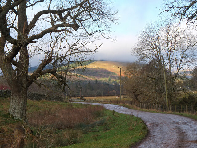
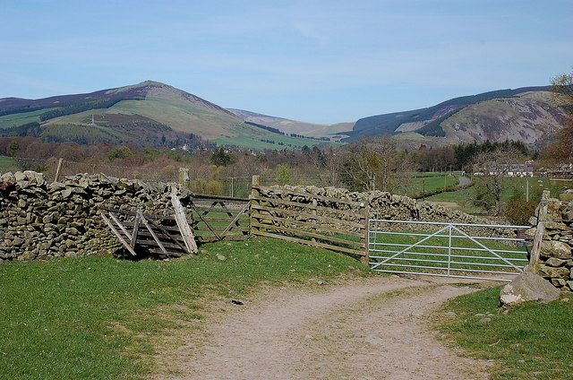
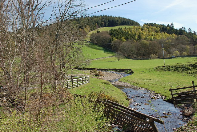
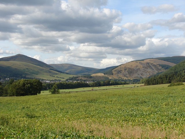
Gardener's Acre is a picturesque region located in Peeblesshire, a historic county in the southern part of Scotland. Known for its stunning landscapes and natural beauty, Gardener's Acre encompasses a diverse range of topographical features, including downs and moorland.

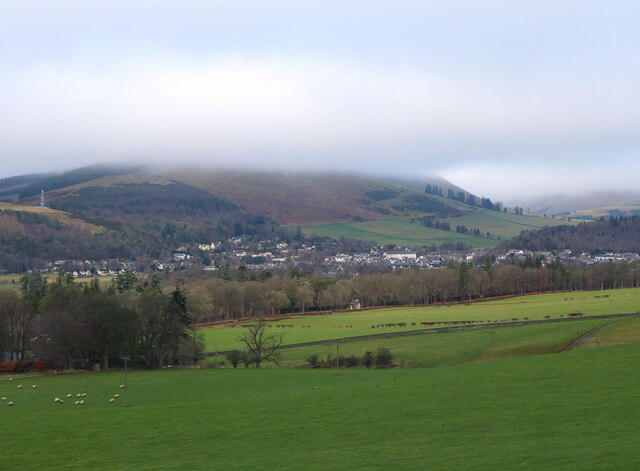
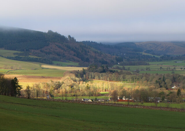
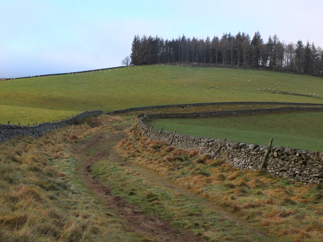
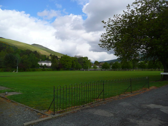
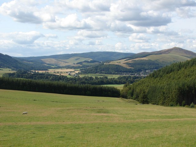
The downs in Gardener's Acre are characterized by their gently rolling hills and expansive grasslands. These open spaces provide a perfect habitat for various plant species, including wildflowers, heather, and grasses. The downs offer breathtaking views of the surrounding countryside, with their uninterrupted panoramas stretching as far as the eye can see.

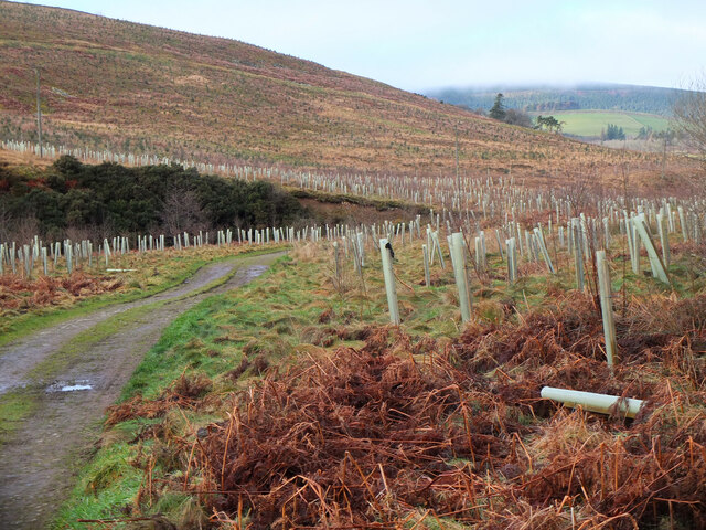
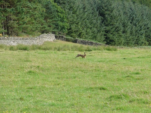
In contrast, the moorland in Gardener's Acre is a more rugged and untamed landscape. It features vast expanses of heather-covered hills, interspersed with peat bogs and scattered patches of woodland. The moorland is home to a variety of wildlife, including red grouse, deer, and birds of prey.

Throughout Gardener's Acre, visitors can enjoy numerous outdoor activities such as hiking, birdwatching, and photography. The region is crisscrossed by a network of walking trails, allowing visitors to explore its diverse terrain at their own pace. Additionally, the area is dotted with charming villages and historic sites, adding cultural richness to the natural beauty.

Gardener's Acre, with its combination of downs and moorland, offers a unique and captivating landscape that attracts nature enthusiasts, hikers, and those seeking tranquility in the heart of Scotland's countryside.

If you have any feedback on the listing, please let us know in the comments section below.

Gardener's Acre Images

Images are sourced within 2km of 55.602755/-3.067338 or Grid Reference NT3234. Thanks to Geograph Open Source API. All images are credited.

Innerleithen from Traquair A view from the Southern Upland Way to the town with Lee Pen in cloud beyond.
Innerleithen from Traquair
A view from the Southern Upland Way to the town with Lee Pen in cloud beyond.
Sunlight at Traquair Patchy sunlight as a low-lying cloud layer thins out above the Tweed valley.
Sunlight at Traquair
Patchy sunlight as a low-lying cloud layer thins out above the Tweed valley.
Shaw Hill, Traquair The Southern Upland Way crosses the east side of the hill with Dean Plantation on its summit.
Shaw Hill, Traquair
The Southern Upland Way crosses the east side of the hill with Dean Plantation on its summit.
New tree plantations, Damhead Coniferous and mixed woodlands have been planted over an area of nearly 300 hectares for Traquair House Charitable Trust - see the website <span class="nowrap"><a title="https://www.forestdirectltd.co.uk/project/damhead-traquair-estate/" rel="nofollow ugc noopener" href="https://www.forestdirectltd.co.uk/project/damhead-traquair-estate/">Link</a><img style="margin-left:2px;" alt="External link" title="External link - shift click to open in new window" src="https://s1.geograph.org.uk/img/external.png" width="10" height="10"/></span> for more details.
New tree plantations, Damhead
Coniferous and mixed woodlands have been planted over an area of nearly 300 hectares for Traquair House Charitable Trust - see the website LinkExternal link for more details.
Track near Damhead The track to the B709 road to Traquair with Lee Pen catching the sun in the background.
Track near Damhead
The track to the B709 road to Traquair with Lee Pen catching the sun in the background.
Roman Catholic Church of St James, Innerleithen
Church Hall for Roman Catholic Church of St James,
Track approaching Damhead farm The track from Damhead Rig passes through the farmyard. The buildings at Traquair village are in the middle distance.
Track approaching Damhead farm
The track from Damhead Rig passes through the farmyard. The buildings at Traquair village are in the middle distance.
Fingland Burn Seen from the road bridge, with Shaw Hill in the background.
Fingland Burn
Seen from the road bridge, with Shaw Hill in the background.
Traquair Kirk Looking to the west.
Traquair Kirk
Looking to the west.
Playing fields at Innerleithen
War memorial at Traquair The solid looking memorial stands at a road junction; Lee Pen is the prominent hill beyond.
War memorial at Traquair
The solid looking memorial stands at a road junction; Lee Pen is the prominent hill beyond.
Minch Moor Bothy The Minch Moor Bothy stands exactly beside the Southern Upland Way, west of Pipers Knowe and on the way to (or from) the 'Marilyn' of Minch Moor.
Minch Moor Bothy
The Minch Moor Bothy stands exactly beside the Southern Upland Way, west of Pipers Knowe and on the way to (or from) the 'Marilyn' of Minch Moor.
View towards the River Tweed near Innerleithen A pleasant view of the River Tweed and surrounding farmland at the start of August.
View towards the River Tweed near Innerleithen
A pleasant view of the River Tweed and surrounding farmland at the start of August.
View towards Innerleithen Looking across from the S.U.W. pathway towards Pirn Craig, with Lee Pen on the far left.
View towards Innerleithen
Looking across from the S.U.W. pathway towards Pirn Craig, with Lee Pen on the far left.
A brown hare A brown hare on the move across the field next to the pathway.
A brown hare
A brown hare on the move across the field next to the pathway.
St. James Roman Catholic Church, Innerleithen A sunny day in Innerleithen, the Church Spire makes a superb backdrop to the fruits of the tree.
St. James Roman Catholic Church, Innerleithen
A sunny day in Innerleithen, the Church Spire makes a superb backdrop to the fruits of the tree.
St. James Roman Catholic Church, Innerleithen A blue sky background to a dramatic subject, a very pretty church, in a lovely village by the River Tweed.
St. James Roman Catholic Church, Innerleithen
A blue sky background to a dramatic subject, a very pretty church, in a lovely village by the River Tweed.
Show me another place!

Gardener's Acre is located at Grid Ref: NT3234 (Lat: 55.602755, Lng: -3.067338)

Unitary Authority: The Scottish Borders

Police Authority: The Lothians and Scottish Borders

What 3 Words

///posed.move.downfield. Near Innerleithen, Scottish Borders

Related Wikis

Traquair

Traquair (Scottish Gaelic: Cille Bhrìghde) is a small village and civil parish in the Scottish Borders; until 1975 it was in the county of Peeblesshire...

Sir Walter Scott Way

The Sir Walter Scott Way is a 92-mile (148 km) long-distance footpath in the Scottish Borders. The route broadly follows the waymarked Southern Upland...

Quair Water

The Quair Water is a tributary of the River Tweed in the Scottish Borders area of Scotland. Its name is related to Traquair. == Etymology == The name Quair...

Traquair House

Traquair House, approximately 7 miles southeast of Peebles, is claimed to be the oldest continually inhabited house in Scotland. Whilst not strictly a...

Nearby Amenities

Located within 500m of 55.602755,-3.067338
Traquair
Place: village
Wikidata: Q7835684
Wikipedia: en:Traquair
Lat/Long: 55.6009011/-3.0636427
War Memorial
Naptan AtcoCode: 69001318
Naptan Bearing: S
Naptan BusStopType: CUS
Naptan CommonName: War Memorial
Naptan Indicator: near Telephone Box
Naptan Landmark: B7062
Naptan NaptanCode: 72726792
Naptan Street: B709
Naptan Verified: no
Source: naptan_import
Lat/Long: 55.6010745/-3.0636038
War Memorial
Naptan AtcoCode: 69001319
Naptan Bearing: N
Naptan BusStopType: CUS
Naptan CommonName: War Memorial
Naptan Indicator: at road junction
Naptan Landmark: B7062
Naptan NaptanCode: 72726835
Naptan Street: B709
Naptan Verified: no
Source: naptan_import
Lat/Long: 55.6011535/-3.0638281
Historic: memorial
Memorial: war_memorial
Lat/Long: 55.6009477/-3.0639947
Post Box
Post Box Type: lamp
Postal Code: EH44
Ref: EH44 42
Source: survey
Lat/Long: 55.6010965/-3.0636917
Traquair Mill
Place: hamlet
Lat/Long: 55.599463/-3.0681207
Cafe
Garden Cafe
Lat/Long: 55.6070318/-3.0661149
Drinking Water
Lat/Long: 55.6001832/-3.0631484
Defibrillator
Defibrillator Location: outside Traquair Village Hall
Emergency: defibrillator
Indoor: no
Ref GB The Circuit: 642CDDE9-58A4-4E7F-827E-AAD4006713BD
Lat/Long: 55.600247/-3.0632313
Telephone
Artwork Type: stained_glass
Booth: K6
Covered: booth
Description: old red phone box with stained glass windows (which is illuminated in the evening)
Listed Status: Category B
Man Made: telephone_box
Tourism: artwork
Lat/Long: 55.6010916/-3.0636603
Power: pole
Lat/Long: 55.5993162/-3.0624233
Power: pole
Lat/Long: 55.6000046/-3.0624149
Power: pole
Lat/Long: 55.600687/-3.0624043
Power: pole
Lat/Long: 55.6013754/-3.0623958
Power: pole
Lat/Long: 55.6058709/-3.0628845
Power: pole
Lat/Long: 55.6057346/-3.0636545
Power: pole
Lat/Long: 55.6055662/-3.0645619
Power: pole
Lat/Long: 55.6053786/-3.0656344
Power: pole
Lat/Long: 55.6051228/-3.0673351
Power: pole
Lat/Long: 55.6049388/-3.068928
Power: pole
Lat/Long: 55.6048217/-3.0704256
Bicycle Parking
Lat/Long: 55.6070234/-3.0662407
Leisure: picnic_table
Lat/Long: 55.6068388/-3.0659027
The data included in this document is from www.openstreetmap.org. The data is made available under ODbL.

Have you been to Gardener's Acre?

Leave your review of Gardener's Acre below (or comments, questions and feedback).