Hyde Lane Park

Downs, Moorland in Somerset Somerset West and Taunton

England

Hyde Lane Park

Taunton Carnival As the moon rises, a police motor cyclist keeps an eye on some of the carnival floats preparing for the 2005 Taunton Carnival procession.
Taunton Carnival Credit: Phil Williams

Hyde Lane Park, located in Somerset, is a picturesque recreational area that offers a serene escape amidst the stunning natural surroundings of the Downs and Moorland. Spanning approximately 20 acres, this park provides a tranquil haven for visitors of all ages.

The park boasts a diverse range of features, making it an ideal destination for outdoor enthusiasts. It offers extensive walking trails, allowing visitors to explore the breathtaking landscapes and enjoy the fresh air. The park is also home to a variety of flora and fauna, providing a rich biodiversity that nature enthusiasts will appreciate.

For families, Hyde Lane Park offers several amenities to enhance their experience. A well-maintained playground area provides a safe and enjoyable space for children to play and interact. Additionally, the park includes picnic spots where visitors can relax and enjoy a meal surrounded by nature.

Nature lovers will be delighted by the park's wildlife observation points, which offer opportunities to spot various bird species and other animals in their natural habitat. The park is committed to environmental preservation and offers educational programs to raise awareness about local wildlife and conservation efforts.

Hyde Lane Park also hosts community events and gatherings throughout the year, fostering a sense of togetherness among residents and visitors. The park's well-maintained facilities, including restrooms and ample parking, ensure convenience for all visitors.

Overall, Hyde Lane Park in Somerset is a haven of natural beauty, offering a range of recreational activities and amenities. Whether seeking solitude in nature or enjoying quality time with loved ones, this park provides an idyllic setting for all.

If you have any feedback on the listing, please let us know in the comments section below.

Hyde Lane Park Images

Images are sourced within 2km of 51.026171/-3.0647658 or Grid Reference ST2525. Thanks to Geograph Open Source API. All images are credited.

Taunton Carnival As the moon rises, a police motor cyclist keeps an eye on some of the carnival floats preparing for the 2005 Taunton Carnival procession.
Taunton Carnival
As the moon rises, a police motor cyclist keeps an eye on some of the carnival floats preparing for the 2005 Taunton Carnival procession.
Taunton Carnival It's rush, rush, rush as start time approaches!  This is a view of some of the carnival floats in the Priory Bridge Road assembly area as they prepare for the 2005 Taunton Carnival procession.
Taunton Carnival
It's rush, rush, rush as start time approaches! This is a view of some of the carnival floats in the Priory Bridge Road assembly area as they prepare for the 2005 Taunton Carnival procession.
Taunton Carnival The 2005 entry form Phoenix Carnival club leaves the assembly area as it starts its journey along the Taunton Carnival procession route.
Taunton Carnival
The 2005 entry form Phoenix Carnival club leaves the assembly area as it starts its journey along the Taunton Carnival procession route.
Taunton Carnival Admiring crowds line the route as the 2005 entry form Gemini Carnival Club starts on its way along the Taunton Carnival procession.  This is a tableau float and the poses will be maintained for the duration of the procession, approximately two hours.
Taunton Carnival
Admiring crowds line the route as the 2005 entry form Gemini Carnival Club starts on its way along the Taunton Carnival procession. This is a tableau float and the poses will be maintained for the duration of the procession, approximately two hours.
Canal bridge, Creech St Michael This bridge carries a footpath over the Bridgwater and Taunton Canal, 150m east of the main road bridge in Creech St Michael.
Canal bridge, Creech St Michael
This bridge carries a footpath over the Bridgwater and Taunton Canal, 150m east of the main road bridge in Creech St Michael.
The Creech Castle Hotel. Taunton A local landmark at the busy junction of the A38 and the A358.
The Creech Castle Hotel. Taunton
A local landmark at the busy junction of the A38 and the A358.
Hankridge Farm Sainsbury's. Taunton's only out of town shopping centre is close to the M5 junction. Other stores on site include B&Q, Comet, Curry's and Halfords but the stores are quite small in comparison with those outside larger towns.
Hankridge Farm Sainsbury's.
Taunton's only out of town shopping centre is close to the M5 junction. Other stores on site include B&Q, Comet, Curry's and Halfords but the stores are quite small in comparison with those outside larger towns.
The Merry Monk. Monkton Heathfield. The conveniently located bus stop is handy for those monks who get a little too merry.
The Merry Monk. Monkton Heathfield.
The conveniently located bus stop is handy for those monks who get a little too merry.
Monkton Elm. Taunton's largest Garden Centre is privately owned. Unlike the national chains the emphasis is still on living plants! On the day the picture was taken Santa Claus himself was visiting.
Monkton Elm.
Taunton's largest Garden Centre is privately owned. Unlike the national chains the emphasis is still on living plants! On the day the picture was taken Santa Claus himself was visiting.
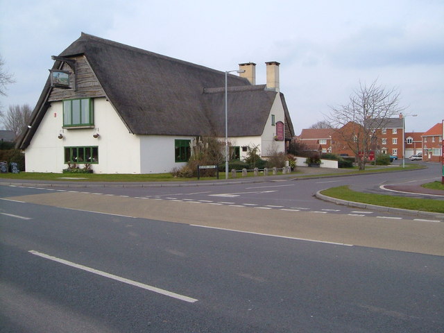
The "Master Thatcher", Taunton It may be thatched but this is a modern pub, next to a Tesco Express and set amidst the extensive housing estates of south-east Taunton. Seen from the south across Lisieux (twin town) Way. 2:30 pm
The "Master Thatcher", Taunton
It may be thatched but this is a modern pub, next to a Tesco Express and set amidst the extensive housing estates of south-east Taunton. Seen from the south across Lisieux (twin town) Way. 2:30 pm
Tractor graveyard beside the A3259 Tractors seem to congregate in this field when their working life is over. The main road leads north eastwards out of Taunton.
Tractor graveyard beside the A3259
Tractors seem to congregate in this field when their working life is over. The main road leads north eastwards out of Taunton.
Sidbrook, near Monkton Heathfield An area of scattered houses on the north eastern fringe of Taunton
Sidbrook, near Monkton Heathfield
An area of scattered houses on the north eastern fringe of Taunton
Gates to Sidbrook Coach House These specially commissioned gates include a coach and horses and each gatepost is topped by a horse's head.
Gates to Sidbrook Coach House
These specially commissioned gates include a coach and horses and each gatepost is topped by a horse's head.
St. Teresa of Lisieux This Roman Catholic Church was built at the same time as the Priorswood (housing) Estate. The smaller building to the right side is accommodation for the clergy. 
Although the usual spelling is St. Theresa, the "h" seems to be missing in this case.
St. Teresa of Lisieux
This Roman Catholic Church was built at the same time as the Priorswood (housing) Estate. The smaller building to the right side is accommodation for the clergy. Although the usual spelling is St. Theresa, the "h" seems to be missing in this case.
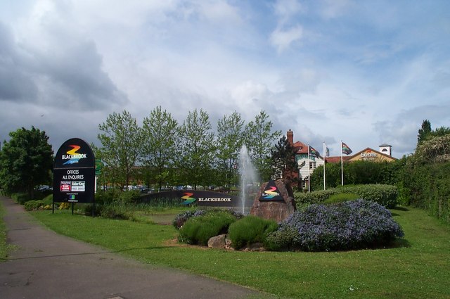
Blackbrook Business Park, Junction 25 of the M5 The Holiday Inn and the Harvester are to the right of the fountain.
Blackbrook Business Park, Junction 25 of the M5
The Holiday Inn and the Harvester are to the right of the fountain.
The Bridgwater  and Taunton Canal passes underneath the M5 This section of the canal towpath is part of the National Cycle Route number 3.
The Bridgwater and Taunton Canal passes underneath the M5
This section of the canal towpath is part of the National Cycle Route number 3.
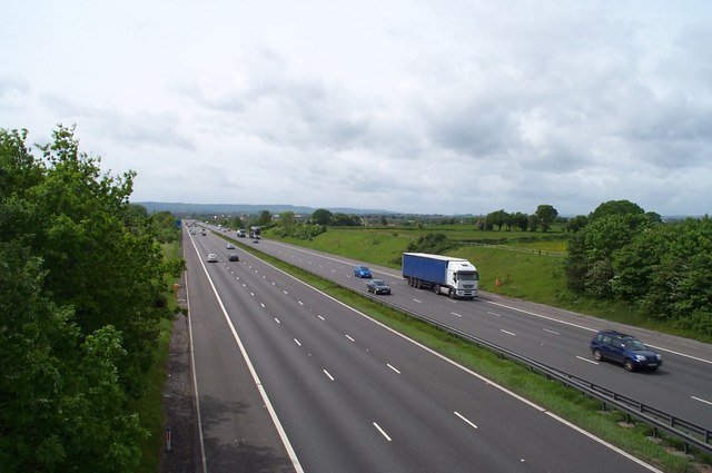
M5 motorway near Creech St. Michael Looking southwest towards Junction 25,about one mile away.
M5 motorway near Creech St. Michael
Looking southwest towards Junction 25,about one mile away.
Ruishton Ruishton was formerly a village but now is virtually joined to Taunton. The large out of town shops are less than a kilometre away along a footpath under the M5.
Ruishton
Ruishton was formerly a village but now is virtually joined to Taunton. The large out of town shops are less than a kilometre away along a footpath under the M5.
Show me another place!

Hyde Lane Park is located at Grid Ref: ST2525 (Lat: 51.026171, Lng: -3.0647658)

Administrative County: Somerset

District: Somerset West and Taunton

Police Authority: Avon and Somerset

What 3 Words

///instance.geese.nightlife. Near Creech St Michael, Somerset

Nearby Locations

Hyde Lane Park

Related Wikis

2011 M5 motorway crash

On 4 November 2011, a multiple-vehicle collision occurred on the M5 motorway near Taunton, Somerset, in South West England. The crash involved dozens of...

Cambria Farm

Cambria Farm is the site of a Bronze, Iron Age, Roman rural settlement, between Ruishton and Taunton, Somerset, England. A survey of the site was carried...

Heathfield Community School

Monkton Wood Academy is an Academy (England and Wales) located at West Monkton in the outskirts of Taunton, England. It had 1,192 pupils aged 11 to 18...

Ruishton

Ruishton is a village and civil parish in Somerset, England, situated on the River Tone and A358 road 2 miles (3.2 km) east of Taunton. The village has...

Nearby Amenities

Located within 500m of 51.026171,-3.0647658
Barrier: bollard
Bicycle: yes
Foot: yes
Lat/Long: 51.0278336/-3.0663096
Broomhay Crossing
Crossing Barrier: yes
Railway: level_crossing
Lat/Long: 51.0257538/-3.0639587
Barrier: cycle_barrier
Lat/Long: 51.0257553/-3.0715859
Crossing
Bicycle: dismount
Crossing: unmarked
Crossing Markings: no
Kerb: lowered
Tactile Paving: yes
Lat/Long: 51.0225003/-3.062864
Crossing
Crossing: uncontrolled
Crossing Markings: zebra
Lat/Long: 51.0241466/-3.0679037
Traffic Calming: bump
Lat/Long: 51.0243827/-3.0667576
Crossing
Bicycle: dismount
Crossing: unmarked
Crossing Markings: no
Kerb: lowered
Tactile Paving: yes
Lat/Long: 51.0222185/-3.0641212
Broomhay Crossing
Crossing Barrier: yes
Railway: level_crossing
Lat/Long: 51.0257946/-3.0639439
Barrier: bollard
Bicycle: yes
Foot: yes
Lat/Long: 51.02935/-3.06421
Give Way
Direction: forward
Lat/Long: 51.0300823/-3.0655437
Passing Place
Lat/Long: 51.0263983/-3.0583733
Give Way
Direction: backward
Lat/Long: 51.0271762/-3.067912
Crossing
Button Operated: yes
Crossing: traffic_signals
Crossing Island: no
Crossing Ref: pelican
Tactile Paving: yes
Traffic Signals Sound: no
Traffic Signals Vibration: yes
Lat/Long: 51.0274921/-3.0670214
Crossing
Bicycle: dismount
Crossing: unmarked
Kerb: lowered
Tactile Paving: yes
Lat/Long: 51.029909/-3.0629472
Heron Gate Office Park
Is In: Somerset, England, United Kingdom
Place: locality
Lat/Long: 51.0217591/-3.0645094
Noexit: yes
Lat/Long: 51.0219092/-3.0643903
Noexit: yes
Lat/Long: 51.0219199/-3.0649957
Crossing
Bicycle: dismount
Crossing: unmarked
Crossing Markings: no
Kerb: lowered
Tactile Paving: yes
Lat/Long: 51.0221194/-3.0641267
Crossing
Bicycle: dismount
Crossing: unmarked
Crossing Markings: no
Kerb: lowered
Tactile Paving: yes
Lat/Long: 51.0227655/-3.0630746
Barrier: bollard
Bicycle: yes
Foot: yes
Material: metal
Lat/Long: 51.0294857/-3.0659697
Barrier: bollard
Bicycle: yes
Foot: yes
Material: metal
Lat/Long: 51.0295639/-3.0658936
Access: yes
Entrance: yes
Wheelchair: yes
Lat/Long: 51.0276438/-3.0659007
Give Way
Lat/Long: 51.026824/-3.0640769
Crossing
Bicycle: dismount
Crossing: unmarked
Kerb: lowered
Tactile Paving: yes
Lat/Long: 51.03009/-3.0631711
Crossing
Bicycle: dismount
Crossing: unmarked
Kerb: lowered
Tactile Paving: yes
Lat/Long: 51.0301018/-3.0633057
Post Box
Brand: Royal Mail
Brand Wikidata: Q638098
Collection Times: Mo-Fr 16:15; Sa 10:30
Mapillary: 3879977288781798
Operator: Royal Mail
Operator Wikidata: Q638098
Post Box Type: pillar
Ref: TA2 185
Survey Date: 2020-03-11
Lat/Long: 51.0274494/-3.0673662
Give Way
Direction: forward
Lat/Long: 51.0244025/-3.0709627
Access: yes
Entrance: yes
Wheelchair: yes
Lat/Long: 51.0241427/-3.0667664
Power: pole
Ref: LAJ5
Lat/Long: 51.0260126/-3.0640219
Power: pole
Lat/Long: 51.0256887/-3.0645798
Power: pole
Lat/Long: 51.0250948/-3.0655561
Power: pole
Lat/Long: 51.0244942/-3.066527
Cycleway: asl
Direction: backward
Lat/Long: 51.0303299/-3.0630837
Access: private
Addr Flats: 31;32;33;34;35;36;37;38;39;40;41;42
Entrance: main
Lat/Long: 51.0303402/-3.0626236
Barrier: bollard
Bicycle: yes
Foot: yes
Material: plastic
Lat/Long: 51.030419/-3.0625986
Access: private
Addr Flats: 52
Entrance: main
Lat/Long: 51.0304323/-3.062713
Post Box
Heron Gate
Collection Times: Mo-Fr 17:00; Sa 12:00
Drive Through: no
Operator: Royal Mail
Operator Wikidata: Q638098
Ref: TA1 714D
Royal Cypher: EIIR
Royal Cypher Wikidata: Q33102113
Lat/Long: 51.022204/-3.062937
Bus Stop
Riverside (S-bound)
Bench: yes
Bus: yes
Direction: 230
Naptan AtcoCode: 3600SOC31014
Naptan Bearing: S
Naptan CommonName: Riverside
Naptan Indicator: S-bound
Naptan NaptanCode: sotajwgj
Naptan PlusbusZoneRef: TAUNTON
Naptan Street: Heron Gate
Naptan Verified: no
Network: Berrys Coaches
Network Wikidata: Q28121432
Operator: Isle Valley Transport
Public Transport: platform
Ref: SF2
Shelter: yes
Lat/Long: 51.0223407/-3.0629174
Waste Basket
Waste: trash
Lat/Long: 51.0295859/-3.0659727
Bench
Backrest: yes
Material: wood
Seats: 4
Lat/Long: 51.0295859/-3.0659841
Waste Basket
Waste: dog_excrement
Lat/Long: 51.0294982/-3.0659986
Give Way
Lat/Long: 51.0296902/-3.0624881
Noexit: yes
Lat/Long: 51.0290947/-3.0635379
Noexit: yes
Lat/Long: 51.0292224/-3.0639454
Access: no
Barrier: lift_gate
Bicycle: no
Foot: no
Lat/Long: 51.0295577/-3.062582
Crossing
Bicycle: dismount
Crossing Island: yes
Kerb: lowered
Tactile Paving: yes
Lat/Long: 51.0298689/-3.0629705
Crossing
Bicycle: dismount
Crossing: unmarked
Kerb: lowered
Tactile Paving: yes
Lat/Long: 51.029823/-3.0629782
Crossing
Bicycle: dismount
Crossing Island: yes
Kerb: lowered
Tactile Paving: yes
Lat/Long: 51.0297436/-3.0634067
Barrier: bollard
Bicycle: yes
Foot: yes
Material: plastic
Lat/Long: 51.0297207/-3.0636174
Crossing
Bicycle: dismount
Crossing: unmarked
Kerb: lowered
Tactile Paving: yes
Lat/Long: 51.0297677/-3.0634778
Crossing
Bicycle: dismount
Crossing: unmarked
Kerb: lowered
Tactile Paving: yes
Lat/Long: 51.0297168/-3.0633605
Crossing
Bicycle: dismount
Crossing Island: yes
Kerb: lowered
Tactile Paving: yes
Lat/Long: 51.0300921/-3.0632359
Barrier: bollard
Bicycle: yes
Foot: yes
Material: plastic
Lat/Long: 51.0301408/-3.0630732
Barrier: bollard
Bicycle: yes
Foot: yes
Material: plastic
Lat/Long: 51.0299317/-3.0628354
Crossing
Bicycle: dismount
Crossing: unmarked
Crossing Markings: no
Kerb: lowered
Tactile Paving: yes
Lat/Long: 51.0225309/-3.0629984
Crossing
Bicycle: dismount
Crossing Island: yes
Kerb: lowered
Tactile Paving: yes
Lat/Long: 51.0225173/-3.0629305
Crossing
Bicycle: dismount
Crossing: unmarked
Crossing Markings: no
Kerb: lowered
Tactile Paving: yes
Lat/Long: 51.0224724/-3.0627762
Give Way
Lat/Long: 51.023004/-3.0636466
Crossing
Bicycle: dismount
Crossing Island: yes
Kerb: lowered
Tactile Paving: yes
Lat/Long: 51.0226772/-3.06259
Crossing
Bicycle: dismount
Crossing Island: yes
Kerb: lowered
Tactile Paving: yes
Lat/Long: 51.0221685/-3.0641194
Crossing
Crossing Island: yes
Kerb: lowered
Tactile Paving: yes
Lat/Long: 51.0270445/-3.0686129
Access: delivery
Entrance: service
Wheelchair: no
Lat/Long: 51.0263664/-3.0683679
Access: delivery
Entrance: service
Lat/Long: 51.026351/-3.0683769
Give Way
Direction: forward
Lat/Long: 51.0269261/-3.0688084
Barrier: bollard
Bicycle: yes
Foot: yes
Material: metal
Lat/Long: 51.0263376/-3.0684828
Barrier: bollard
Bicycle: yes
Foot: yes
Material: metal
Lat/Long: 51.0263863/-3.0686705
Barrier: bollard
Bicycle: yes
Foot: yes
Material: metal
Lat/Long: 51.026442/-3.068644
Barrier: bollard
Bicycle: yes
Foot: yes
Material: metal
Lat/Long: 51.0264659/-3.0686563
Barrier: bollard
Bicycle: yes
Foot: yes
Material: metal
Lat/Long: 51.0264818/-3.0686644
Barrier: bollard
Bicycle: yes
Foot: yes
Material: metal
Lat/Long: 51.0264978/-3.0686716
Barrier: bollard
Bicycle: yes
Foot: yes
Material: metal
Lat/Long: 51.0265179/-3.0686791
Barrier: bollard
Bicycle: yes
Foot: yes
Material: metal
Lat/Long: 51.0265053/-3.0686134
Barrier: bollard
Bicycle: yes
Foot: yes
Material: metal
Lat/Long: 51.0265591/-3.068584
Barrier: bollard
Bicycle: yes
Foot: yes
Material: metal
Lat/Long: 51.0265916/-3.0685662
Barrier: bollard
Bicycle: yes
Foot: yes
Material: metal
Lat/Long: 51.0266132/-3.0685545
Barrier: bollard
Bicycle: yes
Foot: yes
Material: metal
Lat/Long: 51.0266456/-3.0685368
Barrier: bollard
Bicycle: yes
Foot: yes
Material: metal
Lat/Long: 51.026667/-3.0685251
Barrier: bollard
Bicycle: yes
Foot: yes
Material: metal
Lat/Long: 51.0266889/-3.0685145
Barrier: bollard
Bicycle: yes
Foot: yes
Material: metal
Lat/Long: 51.0266977/-3.0685478
Barrier: bollard
Bicycle: yes
Foot: yes
Material: metal
Lat/Long: 51.0267045/-3.0685733
Barrier: bollard
Bicycle: yes
Foot: yes
Material: metal
Lat/Long: 51.0267107/-3.0685969
Barrier: bollard
Bicycle: yes
Foot: yes
Material: metal
Lat/Long: 51.0267274/-3.0685863
Barrier: bollard
Bicycle: yes
Foot: yes
Material: metal
Lat/Long: 51.0267429/-3.0685764
Barrier: bollard
Bicycle: yes
Foot: yes
Material: metal
Lat/Long: 51.0267527/-3.0685842
Barrier: bollard
Bicycle: yes
Foot: yes
Material: metal
Lat/Long: 51.026763/-3.0685917
Barrier: bollard
Bicycle: yes
Foot: yes
Material: metal
Lat/Long: 51.0267694/-3.0685689
Barrier: bollard
Bicycle: yes
Foot: yes
Material: metal
Lat/Long: 51.0267756/-3.0685464
Barrier: bollard
Bicycle: yes
Foot: yes
Material: metal
Lat/Long: 51.0267812/-3.0685252
Barrier: bollard
Bicycle: yes
Foot: yes
Material: metal
Lat/Long: 51.0267932/-3.0685343
Barrier: bollard
Bicycle: yes
Foot: yes
Material: metal
Lat/Long: 51.0268056/-3.0685432
Barrier: bollard
Bicycle: yes
Foot: yes
Material: metal
Lat/Long: 51.0268183/-3.0685533
Barrier: bollard
Bicycle: yes
Foot: yes
Material: metal
Lat/Long: 51.0268311/-3.0685627
Barrier: bollard
Bicycle: yes
Foot: yes
Material: metal
Lat/Long: 51.0268436/-3.0685721
Barrier: bollard
Bicycle: yes
Foot: yes
Material: metal
Lat/Long: 51.0268379/-3.0685925
Barrier: bollard
Bicycle: yes
Foot: yes
Material: metal
Lat/Long: 51.0268313/-3.068615
Barrier: bollard
Bicycle: yes
Foot: yes
Material: metal
Lat/Long: 51.0268252/-3.0686376
Barrier: bollard
Bicycle: yes
Foot: yes
Material: metal
Lat/Long: 51.0268352/-3.0686424
Barrier: bollard
Bicycle: yes
Foot: yes
Material: metal
Lat/Long: 51.0268407/-3.0686215
Barrier: bollard
Bicycle: yes
Foot: yes
Material: metal
Lat/Long: 51.026847/-3.0685989
Barrier: bollard
Bicycle: yes
Foot: yes
Material: metal
Lat/Long: 51.0268532/-3.0685759
Barrier: bollard
Bicycle: yes
Foot: yes
Material: metal
Lat/Long: 51.02686/-3.0685536
Barrier: bollard
Bicycle: yes
Foot: yes
Material: metal
Lat/Long: 51.0268662/-3.0685311
Barrier: bollard
Bicycle: yes
Foot: yes
Material: metal
Lat/Long: 51.026876/-3.0685115
Barrier: bollard
Bicycle: yes
Foot: yes
Material: metal
Lat/Long: 51.026888/-3.0684952
Barrier: bollard
Bicycle: yes
Foot: yes
Material: metal
Lat/Long: 51.0269013/-3.0684828
Barrier: bollard
Bicycle: yes
Foot: yes
Material: metal
Lat/Long: 51.0269109/-3.0684775
Barrier: bollard
Bicycle: yes
Foot: yes
Material: metal
Lat/Long: 51.0269303/-3.0684608
Barrier: bollard
Bicycle: yes
Foot: yes
Material: metal
Lat/Long: 51.0269408/-3.0684471
Barrier: bollard
Bicycle: yes
Foot: yes
Material: metal
Lat/Long: 51.0269509/-3.0684273
Barrier: bollard
Bicycle: yes
Foot: yes
Material: metal
Lat/Long: 51.0269588/-3.0684064
Barrier: bollard
Bicycle: yes
Foot: yes
Material: metal
Lat/Long: 51.0269671/-3.0683774
Barrier: bollard
Bicycle: yes
Foot: yes
Material: metal
Lat/Long: 51.0269733/-3.0683506
Barrier: bollard
Bicycle: yes
Foot: yes
Material: metal
Lat/Long: 51.0269586/-3.0683584
Barrier: bollard
Bicycle: yes
Foot: yes
Material: metal
Lat/Long: 51.0269438/-3.0683678
Barrier: bollard
Bicycle: yes
Foot: yes
Material: metal
Lat/Long: 51.0269317/-3.0683737
Barrier: bollard
Bicycle: yes
Foot: yes
Material: metal
Lat/Long: 51.0269288/-3.0683611
Barrier: bollard
Bicycle: yes
Foot: yes
Material: metal
Lat/Long: 51.026923/-3.0683369
Barrier: bollard
Bicycle: yes
Foot: yes
Material: metal
Lat/Long: 51.0269171/-3.0683128
Barrier: bollard
Bicycle: yes
Foot: yes
Material: metal
Lat/Long: 51.0269119/-3.0682892
Barrier: bollard
Bicycle: yes
Foot: yes
Material: metal
Lat/Long: 51.0269062/-3.0682656
Barrier: bollard
Bicycle: yes
Foot: yes
Material: metal
Lat/Long: 51.0269004/-3.0682412
Barrier: bollard
Bicycle: yes
Foot: yes
Material: metal
Lat/Long: 51.0268944/-3.0682178
Barrier: bollard
Bicycle: yes
Foot: yes
Material: metal
Lat/Long: 51.0268886/-3.068194
Barrier: bollard
Bicycle: yes
Foot: yes
Material: metal
Lat/Long: 51.0268827/-3.0681698
Barrier: bollard
Bicycle: yes
Foot: yes
Material: metal
Lat/Long: 51.026877/-3.0681462
Barrier: bollard
Bicycle: yes
Foot: yes
Material: metal
Lat/Long: 51.0268716/-3.0681232
Barrier: bollard
Bicycle: yes
Foot: yes
Material: metal
Lat/Long: 51.0268662/-3.0681001
Barrier: bollard
Bicycle: yes
Foot: yes
Material: metal
Lat/Long: 51.0268606/-3.068076
Barrier: bollard
Bicycle: yes
Foot: yes
Material: metal
Lat/Long: 51.0268777/-3.0680559
Barrier: bollard
Bicycle: yes
Foot: yes
Material: metal
Lat/Long: 51.0268724/-3.0680315
Barrier: bollard
Bicycle: yes
Foot: yes
Material: metal
Lat/Long: 51.0268669/-3.0680084
Access: customers
Entrance: main
Wheelchair: yes
Lat/Long: 51.0268599/-3.0684268
Access: customers
Entrance: exit
Wheelchair: yes
Lat/Long: 51.0269031/-3.0684244
Crossing
Crossing: uncontrolled
Crossing Ref: zebra
Direction: both
Side: both
Lat/Long: 51.0269909/-3.0684091
Camera Mount: pole
Camera Type: fixed
Height: 4
Man Made: surveillance
Operator: British Waterways
Surveillance: outdoor
Surveillance Type: camera
Surveillance Zone: building
Lat/Long: 51.0300245/-3.0661649
Camera Mount: pole
Camera Type: fixed
Height: 4
Man Made: surveillance
Operator: British Waterways
Surveillance: outdoor
Surveillance Type: camera
Surveillance Zone: building
Lat/Long: 51.0297816/-3.066178
Give Way
Direction: backward
Lat/Long: 51.0298777/-3.0664804
Bathpool
Place: hamlet
Lat/Long: 51.0288147/-3.067358
Direction: backward
Maxspeed: 30 mph
Maxspeed Type: GB:nsl_restricted
Source Maxspeed: sign
Traffic Sign: maxspeed
Lat/Long: 51.0248856/-3.0714177
Post Box
Operator: Royal Mail
Operator Wikidata: Q638098
Post Box Type: lamp
Ref: TA1 571D
Royal Cypher: EIIR
Royal Cypher Wikidata: Q33102113
Lat/Long: 51.0224495/-3.0681179
Cafe
Food Express
Addr City: Taunton
Addr Country: GB
Addr County: Somerset
Addr Housename: B&Q Car Park
Addr Postcode: TA1 2LP
Addr Street: Heron Gate
Fhrs Id: 1348982
Lat/Long: 51.0226316/-3.0653056
Entrance: yes
Lat/Long: 51.0217987/-3.0631639
Traffic Signals
Traffic Signals: signal
Lat/Long: 51.0243751/-3.0712791
Vending Machine
My Key Machine
Brand: My Key Machine
Brand Wikidata: Q113576555
Vending: key
Lat/Long: 51.0228028/-3.0650688
Traffic Signals
Traffic Signals: signal
Lat/Long: 51.0244992/-3.0710728
Charging Station
Access: yes
Capacity: 1
Fee: 0.75 kWh
Operator: InstaVolt
Operator Wikidata: Q111173904
Lat/Long: 51.024177/-3.0671621
Charging Station
Access: yes
Capacity: 1
Fee: 0.75 kWh
Operator: InstaVolt
Operator Wikidata: Q111173904
Lat/Long: 51.0241748/-3.0671366
Traffic Calming: island
Lat/Long: 51.0303758/-3.0630419
Traffic Signals
Traffic Signals: signal
Traffic Signals Direction: backward
Lat/Long: 51.0303522/-3.0630635
Atm
Brand: NoteMachine
Brand Wikidata: Q104368525
Currency GBP: yes
Fee: yes
Operator: NoteMachine
Operator Short: NMATM
Operator Wikidata: Q104368525
Lat/Long: 51.0237274/-3.0666989
The data included in this document is from www.openstreetmap.org. The data is made available under ODbL.

Have you been to Hyde Lane Park?

Leave your review of Hyde Lane Park below (or comments, questions and feedback).