Brown Tongue

Downs, Moorland in Cumberland Copeland

England

Brown Tongue

Fold, Broad Tongue
Fold, Broad Tongue Credit: Mick Garratt

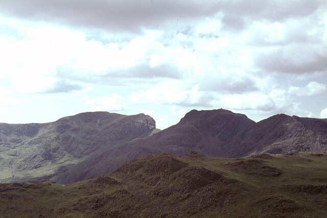
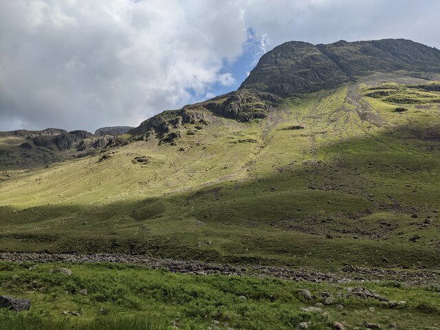
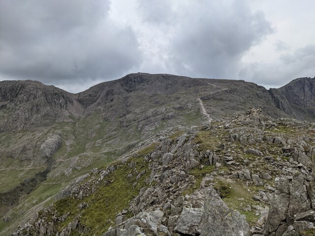
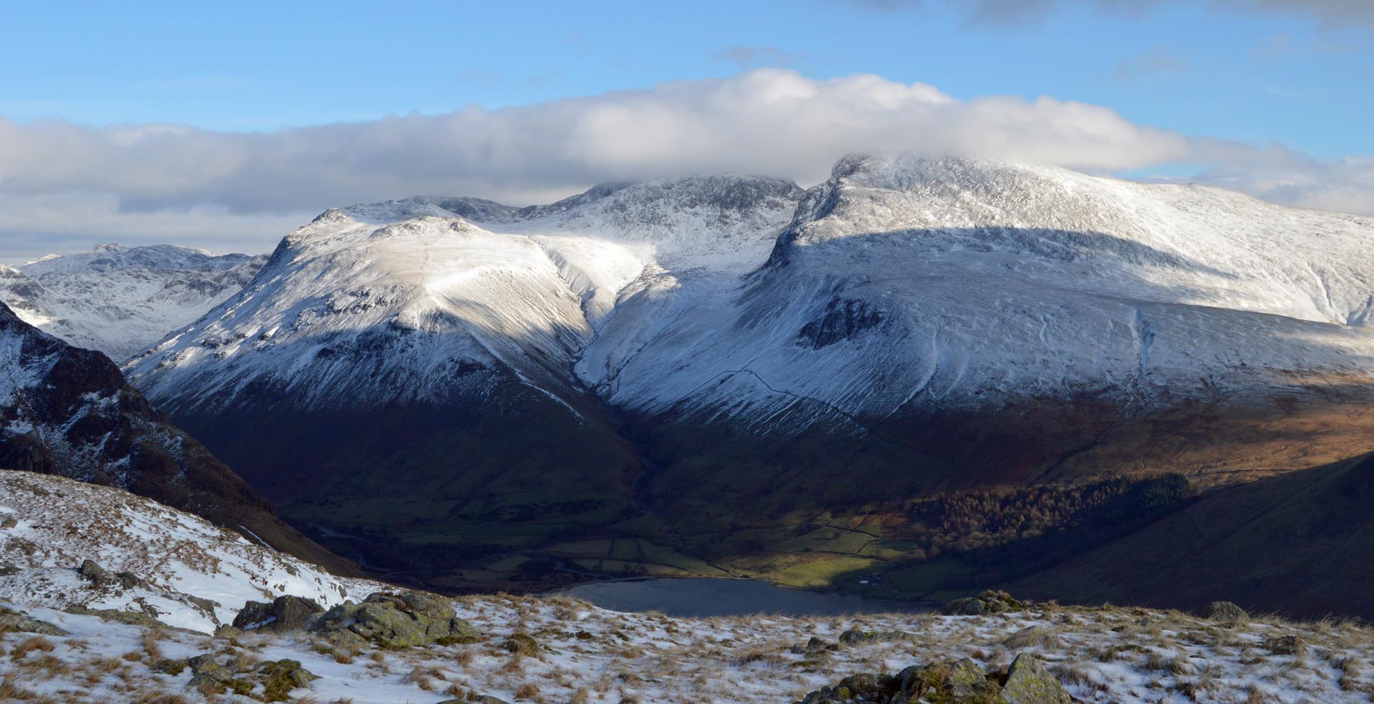
Brown Tongue is a prominent feature located in the northern part of the Lake District National Park, specifically in the region of Cumberland, England. Situated within the larger area known as the Cumberland Downs, Brown Tongue is a notable moorland renowned for its striking natural beauty and ecological significance.

Covering an extensive area, Brown Tongue is characterized by its distinctive brownish hue, which is a result of the predominant presence of heather and bracken vegetation. The moorland is interspersed with pockets of dense forest and scattered rocky outcrops, adding to its picturesque appeal.

This area is renowned for its rich biodiversity, supporting a wide range of flora and fauna. Heather, bilberries, and cotton grass are some of the plant species that thrive in this habitat, while birds such as curlews, red grouse, and skylarks can be spotted in the skies above. Additionally, Brown Tongue serves as an important habitat for mammals such as red deer, foxes, and badgers.

The moorland also holds historical significance, with remnants of ancient settlements and burial mounds dating back to prehistoric times. These archaeological features provide insights into the human occupation of the area throughout the ages.

Brown Tongue offers numerous walking and hiking opportunities, with various trails and paths crisscrossing its expanse. Visitors can immerse themselves in the tranquil beauty of the moorland, enjoy panoramic views of the surrounding landscapes, and experience the unique atmosphere of this captivating natural wonder in Cumberland.

If you have any feedback on the listing, please let us know in the comments section below.

Brown Tongue Images

Images are sourced within 2km of 54.455445/-3.2364192 or Grid Reference NY1907. Thanks to Geograph Open Source API. All images are credited.

Fold, Broad Tongue
Fold, Broad Tongue
Symonds Knott from the summit of Scafell The view is taken from the summit with Symonds Knott being the rise in the ridge and with Great Gable in the background. With thanks to Ian Taylor for pinpointing the camera position.
Symonds Knott from the summit of Scafell
The view is taken from the summit with Symonds Knott being the rise in the ridge and with Great Gable in the background. With thanks to Ian Taylor for pinpointing the camera position.
The Scafells from Bow Fell north ridge In the foreground is the flattish top of the minor hill Pike de Bield. Along the horizon the Scafells stand proud. From left to right we have Sca Fell, Symonds Knott (a fairly modest top but overlooking the sheer drop of Broad Stand), Mickledore (the sharp dip between the two main hills) and Scafell Pike itself. The cairn on this summit, the highest in England at 978m, is clearly seen from 4km away.

Further to the right is Ill Crag. The 'subject' grid ref is for Symonds Knott.
The Scafells from Bow Fell north ridge
In the foreground is the flattish top of the minor hill Pike de Bield. Along the horizon the Scafells stand proud. From left to right we have Sca Fell, Symonds Knott (a fairly modest top but overlooking the sheer drop of Broad Stand), Mickledore (the sharp dip between the two main hills) and Scafell Pike itself. The cairn on this summit, the highest in England at 978m, is clearly seen from 4km away. Further to the right is Ill Crag. The 'subject' grid ref is for Symonds Knott.
Looking across Lingmell Beck
High ground on Lingmell Looking towards Scafell Pike.
High ground on Lingmell
Looking towards Scafell Pike.
A string of people coming up from Hollow Stones
Looking north from Scafell Pike Styhead Tarn is in the distance.
Looking north from Scafell Pike
Styhead Tarn is in the distance.
The upper reaches of Piers Gill
Wasdale Head These former farm buildings are now used to serve tourists with a shop and holiday apartments.
The steep fell in the background is the northern shoulder of Yewbarrow.
There is an Ordnance Survey cut benchmark on the pillar between the doors beyond the yellow defibrillator box (photograph <a href="https://www.geograph.org.uk/photo/7123697">NY1808 : Benchmark, Wasdale Head</a>).
Wasdale Head
These former farm buildings are now used to serve tourists with a shop and holiday apartments. The steep fell in the background is the northern shoulder of Yewbarrow. There is an Ordnance Survey cut benchmark on the pillar between the doors beyond the yellow defibrillator box (photograph NY1808 : Benchmark, Wasdale Head).
Benchmark, Wasdale Head Detail of the Ordnance Survey cut benchmark on a former barn (now a shop and holiday accommodation) at Wasdale Head. In spite of the many years since the benchmark was cut, the darkness of the cut stone still contrasts with the weathered surface of the natural block used in the construction of the barn.
The benchmark marks a height of 80.3483m above sea level (Ordnance Datum Newlyn) last verified in 1956 (location photograph <a href="https://www.geograph.org.uk/photo/7123690">NY1808 : Wasdale Head</a>).
Benchmark, Wasdale Head
Detail of the Ordnance Survey cut benchmark on a former barn (now a shop and holiday accommodation) at Wasdale Head. In spite of the many years since the benchmark was cut, the darkness of the cut stone still contrasts with the weathered surface of the natural block used in the construction of the barn. The benchmark marks a height of 80.3483m above sea level (Ordnance Datum Newlyn) last verified in 1956 (location photograph NY1808 : Wasdale Head).
Moody day at Wasdale Head The morning’s low cloud and rain had cleared and as a foretaste of better weather to come a brief glimpse of sun catches Great Gable between Great Napes and Tom Blue.
Moody day at Wasdale Head
The morning’s low cloud and rain had cleared and as a foretaste of better weather to come a brief glimpse of sun catches Great Gable between Great Napes and Tom Blue.
Wastwater and Wasdale Head Some of the most remote Lakeland country - taken from the path that follows Wastwater through some really brutal scree slopes.
Wastwater and Wasdale Head
Some of the most remote Lakeland country - taken from the path that follows Wastwater through some really brutal scree slopes.
Kettle Cove
Kettle Cove
Long Gill
Long Gill
Queen Victoria (VR) Post Box (1837-1901), Wasdale Head
Packhorse Bridge Over Mosdale Beck, Wasdale Head
Moses Trod (Path), Wasdale Head
St. Olaf's Church, Wasdale Head St Olaf's Church in Wasdale Head, Cumbria, is England's smallest parish church. The earliest record of the church is from 1550, though it probably predates this, and it is likely that there was an earlier church on this site. The church was dedicated to St Olaf in 1977, before which it had no name.

<span class="nowrap"><a title="https://en.wikipedia.org/wiki/St_Olaf%27s_Church,_Wasdale" rel="nofollow ugc noopener" href="https://en.wikipedia.org/wiki/St_Olaf%27s_Church,_Wasdale">Link</a><img style="margin-left:2px;" alt="External link" title="External link - shift click to open in new window" src="https://s1.geograph.org.uk/img/external.png" width="10" height="10"/></span>
St. Olaf's Church, Wasdale Head
St Olaf's Church in Wasdale Head, Cumbria, is England's smallest parish church. The earliest record of the church is from 1550, though it probably predates this, and it is likely that there was an earlier church on this site. The church was dedicated to St Olaf in 1977, before which it had no name. LinkExternal link
Show me another place!

Brown Tongue is located at Grid Ref: NY1907 (Lat: 54.455445, Lng: -3.2364192)

Administrative County: Cumbria

District: Copeland

Police Authority: Cumbria

What 3 Words

///solicitor.nooks.spreading. Near Seascale, Cumbria

Nearby Locations

Brown Tongue

Related Wikis

Scafell

Scafell ( or ; also spelled Sca Fell, previously Scawfell) is a mountain in the Lake District region of Cumbria, England. It has a height of 964 metres...

Mickledore

Mickledore (the name means great door or pass) is a narrow ridge, 840 metres (2755 ft) high, connecting the mountains of Scafell and Scafell Pike in the...

Lingmell

Lingmell is a fell in the English Lake District, standing above the village of Wasdale Head. It is an outlier on the north-west flank of Scafell Pike,...

Wasdale Head

Wasdale Head (; traditionally ) is a scattered agricultural hamlet in the Lake District National Park in Cumbria, England. Wasdale Head claims to be home...

Related Videos

Climbing Scafell Pike Via Wasdale Head - Simply Stunning (Lake District, Cumbria, North England)

SUBSCRIBE by clicking here: https://www.youtube.com/channel/UCB9R-J4V0UE0apMJiws9EQQ?sub_confirmation=1 The ...

A Simple Guide to Scafell Pike | Hiking, Camping, Itinerary | Filipino UK Travel

A Simple Guide to Scafell Pike | Hiking, Camping, Itinerary | Filipino UK Travel Hello and welcome to Life Adventure Philippines!

Nearby Amenities

Located within 500m of 54.455445,-3.2364192
Ford: yes
Lat/Long: 54.4558977/-3.2429861
Brown Tongue
Place: locality
Lat/Long: 54.4559138/-3.2397071
Lingmell Scars
Place: locality
Lat/Long: 54.4569793/-3.2404497
Ford: yes
Lat/Long: 54.453778/-3.2331532
Ford: yes
Lat/Long: 54.4537794/-3.2331766
Ford: yes
Lat/Long: 54.4537786/-3.2340445
The data included in this document is from www.openstreetmap.org. The data is made available under ODbL.

Have you been to Brown Tongue?

Leave your review of Brown Tongue below (or comments, questions and feedback).