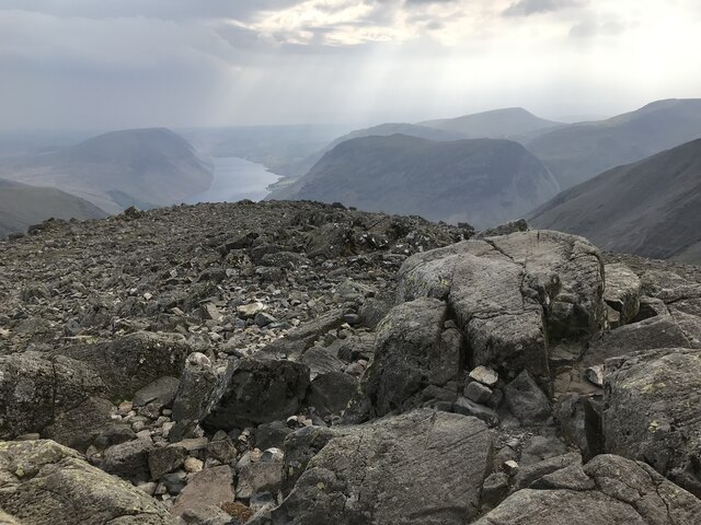
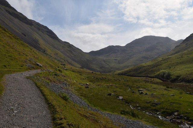
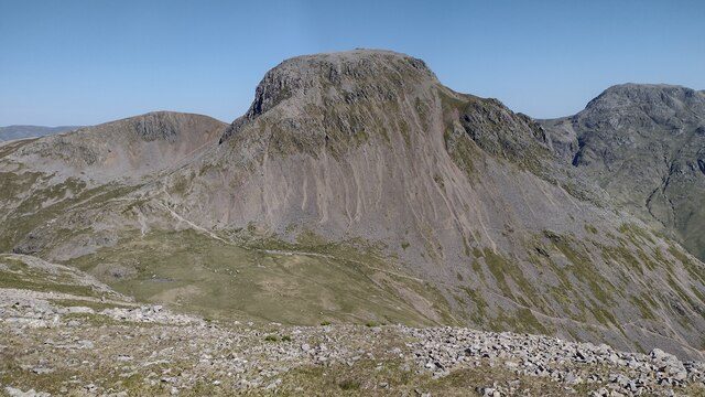
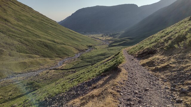
Wasdale Fell

Downs, Moorland in Cumberland Copeland

England

Wasdale Fell

Great Gable Summit
Great Gable Summit Credit: Anthony Foster

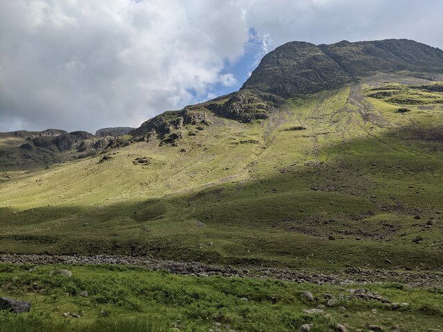
Wasdale Fell is a picturesque area located in the Lake District National Park, in the county of Cumberland, England. It is known for its stunning rolling hills, expansive moorlands, and breath-taking views of the surrounding valleys and mountains.

Covering an area of approximately 200 square kilometers, Wasdale Fell offers a diverse landscape that attracts outdoor enthusiasts and nature lovers alike. The fells, or hills, in the area provide ample opportunities for hiking, climbing, and mountaineering. Scafell Pike, England's highest peak, is situated in Wasdale Fell, making it a popular destination for avid climbers.

The moorland in Wasdale Fell is characterized by its wild and rugged beauty. It is home to a variety of flora and fauna, including heather, mosses, and rare bird species. The moorland also plays a vital role in water conservation, helping to maintain the area's natural water resources.

Downs, or grassy slopes, can also be found in Wasdale Fell. These areas offer breathtaking views of the surrounding countryside and are often used for sheep grazing. The downs are known for their rich biodiversity, with a wide range of plant and animal species thriving in this habitat.

Wasdale Fell is not only renowned for its natural beauty but also for its historical significance. The area is rich in archaeological sites, including Neolithic stone circles and Bronze Age burial mounds. These remnants of the past provide insights into the early human settlements in the region.

Overall, Wasdale Fell offers a captivating blend of natural wonders, outdoor activities, and historical charm, making it a must-visit destination for those seeking to explore the beauty of the Lake District.

If you have any feedback on the listing, please let us know in the comments section below.

Wasdale Fell Images

Images are sourced within 2km of 54.474583/-3.2421972 or Grid Reference NY1909. Thanks to Geograph Open Source API. All images are credited.

Great Gable Summit
Great Gable Summit
Great Gable Summit
Great Gable Summit
Kirkfell Crags Mountain walkers descending towards Black Sail Pass beyond which rises Kirk Fell where the several buttresses of Kirkfell Crags can be seen.
Kirkfell Crags
Mountain walkers descending towards Black Sail Pass beyond which rises Kirk Fell where the several buttresses of Kirkfell Crags can be seen.
Great Gable from Lingmell There are many routes up Great Gable, 899m, but probably the  easiest one is along the ridge to the right.

This photo was sent to me by Michael Earnshaw as an example of the quality of a scanned image. For a very similar comparison, see <a href="https://www.geograph.org.uk/photo/7555318">NY2110 : Great Gable from Lingmell</a>.
Great Gable from Lingmell
There are many routes up Great Gable, 899m, but probably the easiest one is along the ridge to the right. This photo was sent to me by Michael Earnshaw as an example of the quality of a scanned image. For a very similar comparison, see NY2110 : Great Gable from Lingmell.
Great Gable from Lingmell
Walkers on the path to Sty Head
Bridleway in Mosedale This bridleway in Mosedale leads up to the Black Sail Pass.
Bridleway in Mosedale
This bridleway in Mosedale leads up to the Black Sail Pass.
Gatherstone Beck Mountain stream above Mosedale with Looking Stead, part of Pillar in the background.
Gatherstone Beck
Mountain stream above Mosedale with Looking Stead, part of Pillar in the background.
Gatherstone Beck Mountain stream, a mountain stream above Mosedale viewed from the bridleway leading to Black Sail Pass.
Gatherstone Beck
Mountain stream, a mountain stream above Mosedale viewed from the bridleway leading to Black Sail Pass.
Bridleway crossing Gatherstone Beck Bridleway crossing Gatherstone Beck in Mosedale.
Bridleway crossing Gatherstone Beck
Bridleway crossing Gatherstone Beck in Mosedale.
Bridleway ascending Black Sail Pass  View down into Mosedale from the bridleway on Black Sail Pass.  On the other side of the valley Yewbarrow can be seen on the left with Red Pike to the right.
Bridleway ascending Black Sail Pass
View down into Mosedale from the bridleway on Black Sail Pass. On the other side of the valley Yewbarrow can be seen on the left with Red Pike to the right.
Cairn on Black Sail Pass Cairn beside the bridleway on Black Sail Pass between the valleys of Mosedale and Ennerdale.
Cairn on Black Sail Pass
Cairn beside the bridleway on Black Sail Pass between the valleys of Mosedale and Ennerdale.
Top of Black Sail Pass Green Gable, Windy Gap, and part of Great Gable and Kirf Fell can be seen in the background.
Top of Black Sail Pass
Green Gable, Windy Gap, and part of Great Gable and Kirf Fell can be seen in the background.
Kirk Fell and the Scafells The southern slopes of Kirk Fell with Scafell Pike and Scafell viewed from the path ascending Pillar.
Kirk Fell and the Scafells
The southern slopes of Kirk Fell with Scafell Pike and Scafell viewed from the path ascending Pillar.
Path heading up the Mosedale valley Path from Wasdale Head heading up the Mosedale valley
Path heading up the Mosedale valley
Path from Wasdale Head heading up the Mosedale valley
Coming down to Beck Head Coming down from Kirk Fell to Beck Head looking towards Great Gable
Coming down to Beck Head
Coming down from Kirk Fell to Beck Head looking towards Great Gable
Bridleway heading down Lingmell Bridleway from Sty Head heading down Lingmell to Wasdale Head
Bridleway heading down Lingmell
Bridleway from Sty Head heading down Lingmell to Wasdale Head
Looking across Lingmell Beck
Show me another place!

Wasdale Fell is located at Grid Ref: NY1909 (Lat: 54.474583, Lng: -3.2421972)

Administrative County: Cumbria

District: Copeland

Police Authority: Cumbria

What 3 Words

///terms.landlady.baseline. Near Keswick, Cumbria

Nearby Locations

Highnose Head Wasdale Fell

Related Wikis

Kirk Fell

Kirk Fell is a fell in the Western part of the English Lake District. It is situated between Great Gable and Pillar on the long ring of fells surrounding...

Wasdale Head

Wasdale Head (; traditionally ) is a scattered agricultural hamlet in the Lake District National Park in Cumbria, England. Wasdale Head claims to be home...

St Olaf's Church, Wasdale

St Olaf's Church in Wasdale Head, Cumbria, is England's smallest parish church. The earliest record of a church on this site is from 1550, though it is...
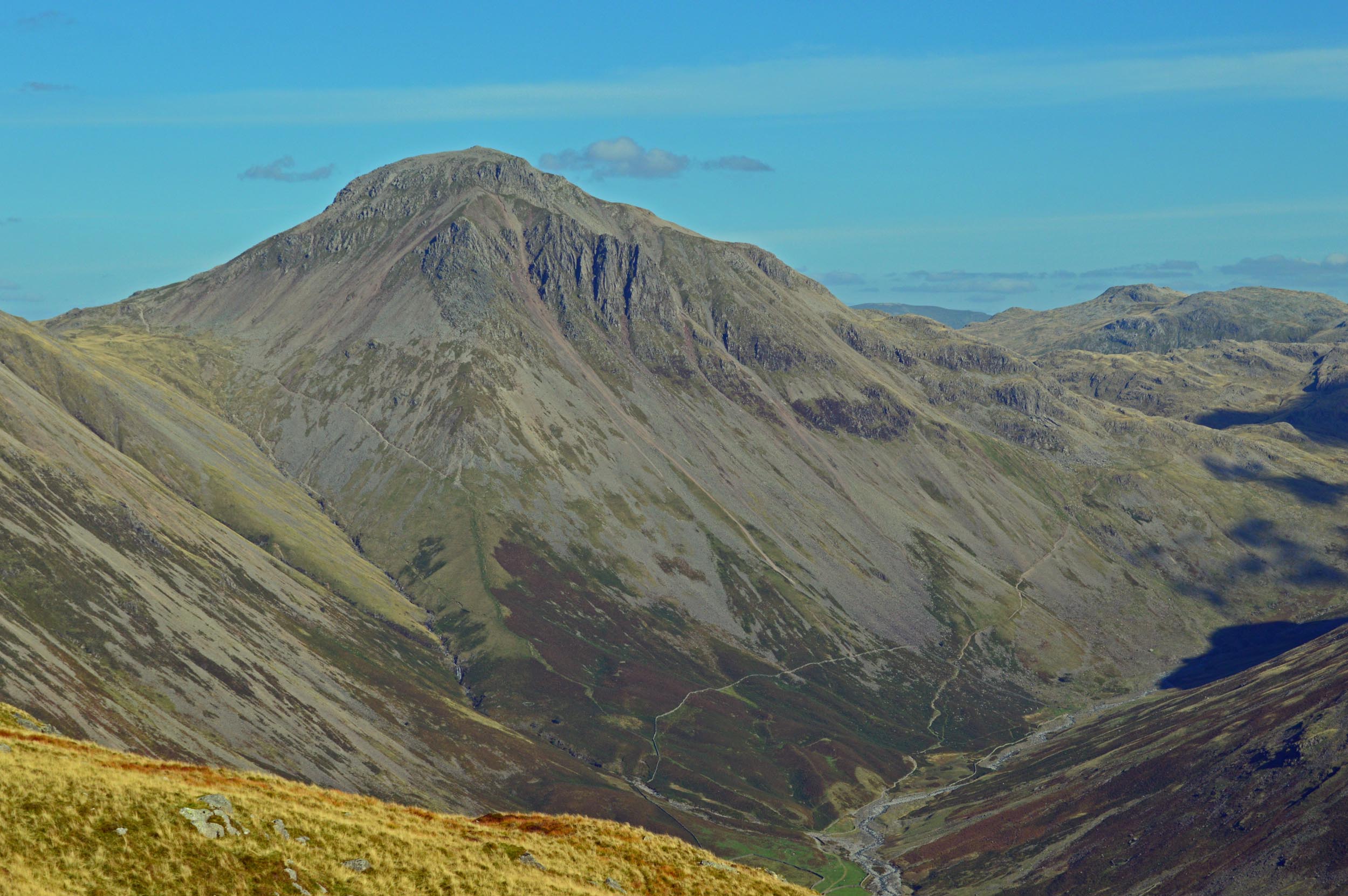
Great Gable

Great Gable is a mountain in the Lake District, United Kingdom. It is named after its appearance as a pyramid from Wasdale, though it is dome-shaped from...

Nearby Amenities

Located within 500m of 54.474583,-3.2421972
Birker Holes
Place: locality
Lat/Long: 54.4736395/-3.2403069
Holmgill Knotts
Place: locality
Lat/Long: 54.4785611/-3.2432364
Ford: yes
Lat/Long: 54.470373/-3.2401749
Ford: yes
Lat/Long: 54.4711982/-3.2379986
Ford: yes
Lat/Long: 54.47146/-3.2372416
Natural: rock
Lat/Long: 54.4735075/-3.2371508
Natural: rock
Lat/Long: 54.4730731/-3.2351933
Natural: rock
Lat/Long: 54.475661/-3.2394272
The data included in this document is from www.openstreetmap.org. The data is made available under ODbL.

Have you been to Wasdale Fell?

Leave your review of Wasdale Fell below (or comments, questions and feedback).