Shaw Moss

Downs, Moorland in Cumberland Copeland

England

Shaw Moss

A595 at Buckman Brow
A595 at Buckman Brow Credit: Colin Pyle

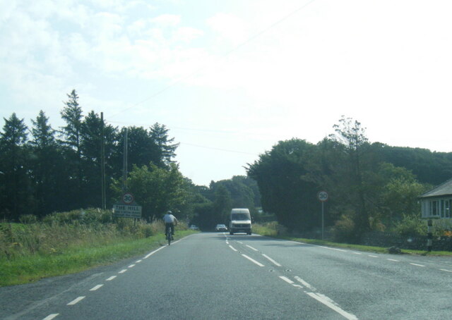
Shaw Moss, located in Cumberland, is a unique and picturesque area known for its stunning natural beauty. It is situated in the Downs region, surrounded by sprawling moorland and rolling hills. The landscape is characterized by its vast expanses of moss-covered terrain, which gives the area its distinctive name.

The moss at Shaw Moss is a type of peat bog, formed over centuries by the accumulation of decaying plant matter. This creates a wet and spongy surface, with patches of vibrant green moss stretching as far as the eye can see. The moss is a vital ecological feature, providing a habitat for various plant species, insects, and small animals.

The Cumberland Downs, where Shaw Moss is located, offers breathtaking views of the surrounding countryside. Visitors can enjoy long walks or hikes along the many trails that wind through the moorland, taking in the peaceful atmosphere and immersing themselves in nature.

The area is also home to a rich diversity of wildlife. Birdwatchers will be delighted by the numerous species of birds that inhabit the moorland, including the rare and elusive merlin and hen harrier. Deer can often be spotted grazing on the hillsides, adding to the serene and natural ambiance of the landscape.

Shaw Moss, Cumberland, is a place of tranquility and natural wonder, providing visitors with a unique opportunity to experience the beauty of the countryside. Whether exploring the moss-covered terrain or admiring the panoramic views, this area is a must-visit for nature enthusiasts and those seeking a peaceful retreat.

If you have any feedback on the listing, please let us know in the comments section below.

Shaw Moss Images

Images are sourced within 2km of 54.255995/-3.2443969 or Grid Reference SD1985. Thanks to Geograph Open Source API. All images are credited.

A595 at Buckman Brow
A5093 at The Green village boundary
A5093 at The Hill village boundary
The Punch Bowl Inn, The Green, Millom
Ordnance Survey Cut Mark This OS cut mark can be found adjacent to the letter box at Broadgate. It marks a point 107.274m above mean sea level.
Ordnance Survey Cut Mark
This OS cut mark can be found adjacent to the letter box at Broadgate. It marks a point 107.274m above mean sea level.
Ordnance Survey Cut Mark This OS cut mark can be found on Old Hall Cottage. It marks a point 39.156m above mean sea level.
Ordnance Survey Cut Mark
This OS cut mark can be found on Old Hall Cottage. It marks a point 39.156m above mean sea level.
Ordnance Survey Cut Mark This OS cut mark can be found on Briar Dene. It marks a point 19.020m above mean sea level.
Ordnance Survey Cut Mark
This OS cut mark can be found on Briar Dene. It marks a point 19.020m above mean sea level.
SRPS Cumbrian Coast Railtour 2018 : Green Road Station
SRPS Cumbrian Coast Railtour 2018 : Signal Post Before Duddon Viaduct
SRPS Cumbrian Coast Railtour 2018 : Approaching Duddon Viaduct
Boundary Stone Toppled and damaged, over stream, south side of the A595.
Boundary Stone
Toppled and damaged, over stream, south side of the A595.
Ordnance Survey Cut Mark This OS cut mark can be found on the gatepost south side of the road. It marks a point 59.576m above mean sea level.
Ordnance Survey Cut Mark
This OS cut mark can be found on the gatepost south side of the road. It marks a point 59.576m above mean sea level.
Ordnance Survey Cut Mark This OS cut mark can be found on the large boulder in the wall SE side of the road. It marks a point 99.048m above mean sea level.
Ordnance Survey Cut Mark
This OS cut mark can be found on the large boulder in the wall SE side of the road. It marks a point 99.048m above mean sea level.
Ordnance Survey OSBM Bolt This OS Bolt can be found on the large boulder at the side of the barn at Low Broadgate. It marks a point 81.764m above mean sea level.
Ordnance Survey OSBM Bolt
This OS Bolt can be found on the large boulder at the side of the barn at Low Broadgate. It marks a point 81.764m above mean sea level.
Ordnance Survey Cut Mark This OS cut mark can be found on the wall NW side of the road. It marks a point 98.207m above mean sea level.
Ordnance Survey Cut Mark
This OS cut mark can be found on the wall NW side of the road. It marks a point 98.207m above mean sea level.
Ordnance Survey Cut Mark This OS cut mark can be found on the brick building at Waltham Nursery. It marks a point 5.925m above mean sea level.
Ordnance Survey Cut Mark
This OS cut mark can be found on the brick building at Waltham Nursery. It marks a point 5.925m above mean sea level.
Ordnance Survey Cut Mark This OS cut mark can be found on a gatepost SE side of the track. It marks a point 6.172m above mean sea level.
Ordnance Survey Cut Mark
This OS cut mark can be found on a gatepost SE side of the track. It marks a point 6.172m above mean sea level.
Ordnance Survey Flush Bracket (G3077) This OS Flush Bracket can be found on The Oaks. It marks a point 35.752m above mean sea level.
Ordnance Survey Flush Bracket (G3077)
This OS Flush Bracket can be found on The Oaks. It marks a point 35.752m above mean sea level.
Show me another place!

Shaw Moss is located at Grid Ref: SD1985 (Lat: 54.255995, Lng: -3.2443969)

Administrative County: Cumbria

District: Copeland

Police Authority: Cumbria

What 3 Words

///elsewhere.motivations.blesses. Near Millom, Cumbria

Related Wikis

Millom Without

Millom Without is a civil parish in the county of Cumbria, England. It had a population of 1,638 in 2001, decreasing to 859 at the 2011 Census. Millom...

Thwaites, Cumbria

Thwaites is a small village near Duddon Valley and on the edge of the Duddon Estuary in the Lake District National Park in the Borough of Copeland, Cumbria...

St Anne's Church, Thwaites

St Anne's Church is in the village of Thwaites, Cumbria, England. It is an active Anglican parish church in the deanery of Millom, the archdeaconry of...

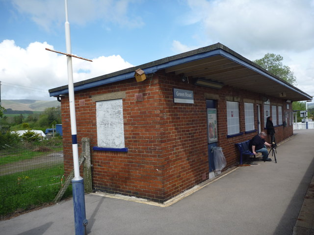
Green Road railway station

Green Road is a railway station on the Cumbrian Coast Line, which runs between Carlisle and Barrow-in-Furness. The station, situated 13+1⁄2 miles (22 km...

Foxfield railway station

Foxfield is a railway station on the Cumbrian Coast Line, which runs between Carlisle and Barrow-in-Furness. The station, situated 11+1⁄2 miles (19 km...

Foxfield, Cumbria

Foxfield is a village on the west coast of Cumbria, England, in the Furness district that was part of Lancashire from 1182 to 1974. It lies on the Duddon...

Arnaby

Arnaby is a village in Cumbria, England.

Eccle Riggs

Eccle Riggs is a country house located on Eccle Riggs, a ridge of land about 0.75 miles (1.2 km) to the south of Broughton-in-Furness, Cumbria, England...

Nearby Amenities

Located within 500m of 54.255995,-3.2443969
Railway: level_crossing
Lat/Long: 54.2569369/-3.2377391
Power: tower
Lat/Long: 54.2597002/-3.2421008
Power: tower
Lat/Long: 54.2558021/-3.2474733
Power: tower
Lat/Long: 54.2536523/-3.2503915
Power: tower
Lat/Long: 54.2577747/-3.2447106
Power: pole
Lat/Long: 54.2582888/-3.2506846
Railway: level_crossing
Lat/Long: 54.2569422/-3.2377998
The data included in this document is from www.openstreetmap.org. The data is made available under ODbL.

Have you been to Shaw Moss?

Leave your review of Shaw Moss below (or comments, questions and feedback).