Braehungie

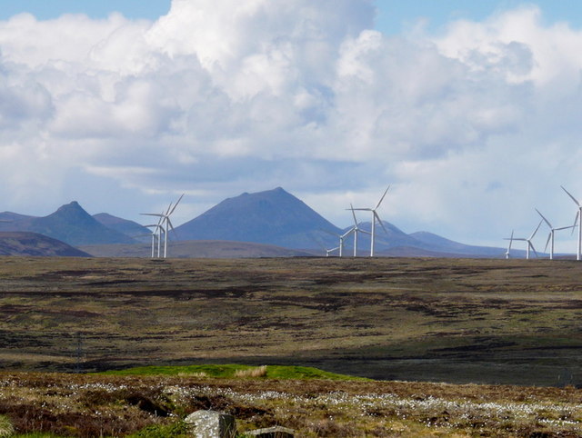
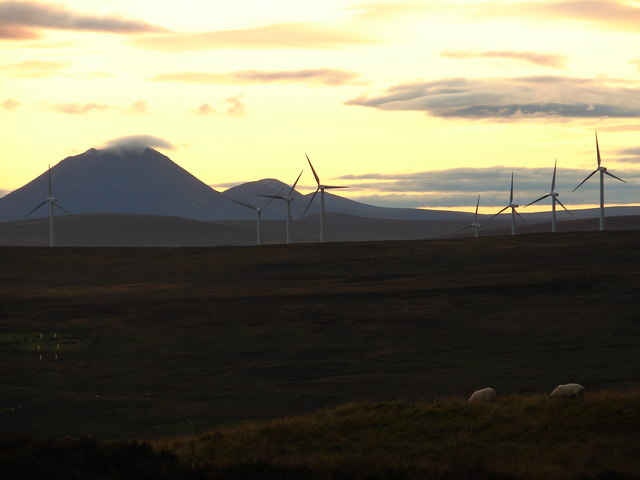
Downs, Moorland in Caithness

Scotland

Braehungie

Moorland near Den Moss Looking over towards the windfarm in ND1535.
Moorland near Den Moss Credit: sylvia duckworth

Braehungie is a picturesque village located in the northeastern region of Caithness, Scotland. Situated amidst stunning natural beauty, it is primarily known for its enchanting downs and moorland landscapes. The village is nestled at the foot of rolling hills, offering breathtaking views of the surrounding countryside.

The downs of Braehungie are characterized by vast expanses of open grassland, adorned with colorful wildflowers during the summer months. These downs provide a habitat for various bird species, making it a popular spot for birdwatching enthusiasts. The moorland, on the other hand, features a rugged terrain with heather-covered hills and peat bogs, creating a unique and untouched atmosphere.

Despite its rural location, Braehungie is not devoid of amenities. The village boasts a small but vibrant community, with a local pub serving as a gathering place for residents and visitors alike. Additionally, there are a few quaint bed and breakfast accommodations available for those wishing to immerse themselves in the tranquility of the area.

For outdoor enthusiasts, Braehungie offers numerous opportunities for exploration and leisure activities. Hiking and walking trails crisscross the downs and moorland, providing the perfect setting for long strolls and invigorating treks. The village also benefits from its proximity to the North Sea, allowing visitors to enjoy coastal walks and witness the dramatic cliffs that line the shoreline.

Overall, Braehungie, Caithness, with its downs and moorland, presents an idyllic setting for nature lovers seeking a peaceful retreat in the heart of Scotland's captivating countryside.

If you have any feedback on the listing, please let us know in the comments section below.

Braehungie Images

Images are sourced within 2km of 58.313518/-3.4014224 or Grid Reference ND1736. Thanks to Geograph Open Source API. All images are credited.

Moorland near Den Moss Looking over towards the windfarm in ND1535.
Moorland near Den Moss
Looking over towards the windfarm in ND1535.
Moorland sundown Den Moss and a gathering dusk.
Moorland sundown
Den Moss and a gathering dusk.
Ruin and Tree
Ruin and Tree
Den Moss from the A9
Ruined Croft Buildings Another Caithness ruin. One day I'm going to try and photograph them all!!
Ruined Croft Buildings
Another Caithness ruin. One day I'm going to try and photograph them all!!
Off-road Parking Area, A9 north of Latheron The A9 is a strategic link between the Highlands of Scotland and the Central Belt. Running for 273 miles, it is the longest road in Scotland and the fifth-longest A-road in the United Kingdom. Historically it was the main road between Edinburgh and John o' Groats but its importance has been eclipsed somewhat in the south by the A90 across the Forth Road Bridge and the M90 motorway, which now links Edinburgh more directly with Perth, and the M9, which is now the main road between Edinburgh and Bridge of Allan.
Off-road Parking Area, A9 north of Latheron
The A9 is a strategic link between the Highlands of Scotland and the Central Belt. Running for 273 miles, it is the longest road in Scotland and the fifth-longest A-road in the United Kingdom. Historically it was the main road between Edinburgh and John o' Groats but its importance has been eclipsed somewhat in the south by the A90 across the Forth Road Bridge and the M90 motorway, which now links Edinburgh more directly with Perth, and the M9, which is now the main road between Edinburgh and Bridge of Allan.
A9 north of Latheron The A9 is a strategic link between the Highlands of Scotland and the Central Belt. Running for 273 miles, it is the longest road in Scotland and the fifth-longest A-road in the United Kingdom. Historically it was the main road between Edinburgh and John o' Groats but its importance has been eclipsed somewhat in the south by the A90 across the Forth Road Bridge and the M90 motorway, which now links Edinburgh more directly with Perth, and the M9, which is now the main road between Edinburgh and Bridge of Allan.
A9 north of Latheron
The A9 is a strategic link between the Highlands of Scotland and the Central Belt. Running for 273 miles, it is the longest road in Scotland and the fifth-longest A-road in the United Kingdom. Historically it was the main road between Edinburgh and John o' Groats but its importance has been eclipsed somewhat in the south by the A90 across the Forth Road Bridge and the M90 motorway, which now links Edinburgh more directly with Perth, and the M9, which is now the main road between Edinburgh and Bridge of Allan.
Electricity Pylon west of the A9 View westwards from the A9.
Electricity Pylon west of the A9
View westwards from the A9.
Ruined Croft by the side of the A9
Layby on the A9 near Crofts of Benachielt The A9 is a strategic link between the Highlands of Scotland and the Central Belt. Running for 273 miles, it is the longest road in Scotland and the fifth-longest A-road in the United Kingdom. Historically it was the main road between Edinburgh and John o' Groats but its importance has been eclipsed somewhat in the south by the A90 across the Forth Road Bridge and the M90 motorway, which now links Edinburgh more directly with Perth, and the M9, which is now the main road between Edinburgh and Bridge of Allan.
Layby on the A9 near Crofts of Benachielt
The A9 is a strategic link between the Highlands of Scotland and the Central Belt. Running for 273 miles, it is the longest road in Scotland and the fifth-longest A-road in the United Kingdom. Historically it was the main road between Edinburgh and John o' Groats but its importance has been eclipsed somewhat in the south by the A90 across the Forth Road Bridge and the M90 motorway, which now links Edinburgh more directly with Perth, and the M9, which is now the main road between Edinburgh and Bridge of Allan.
Power Lines Crossing the A9 near Crofts of Benachielt The A9 is a strategic link between the Highlands of Scotland and the Central Belt. Running for 273 miles, it is the longest road in Scotland and the fifth-longest A-road in the United Kingdom. Historically it was the main road between Edinburgh and John o' Groats but its importance has been eclipsed somewhat in the south by the A90 across the Forth Road Bridge and the M90 motorway, which now links Edinburgh more directly with Perth, and the M9, which is now the main road between Edinburgh and Bridge of Allan.
Power Lines Crossing the A9 near Crofts of Benachielt
The A9 is a strategic link between the Highlands of Scotland and the Central Belt. Running for 273 miles, it is the longest road in Scotland and the fifth-longest A-road in the United Kingdom. Historically it was the main road between Edinburgh and John o' Groats but its importance has been eclipsed somewhat in the south by the A90 across the Forth Road Bridge and the M90 motorway, which now links Edinburgh more directly with Perth, and the M9, which is now the main road between Edinburgh and Bridge of Allan.
Masts near Benachielt Trig Point
Benachielt Trig Point Flush Bracket S6842
View from the A9 Looking south towards Scaraben and other hills.
View from the A9
Looking south towards Scaraben and other hills.
The A9 near Creag Liath Taking advantage of a large layby for a short break from driving. Creag Liath is the unremarkable hill on the right here. The red-roofed building is unnamed on the maps.
The A9 near Creag Liath
Taking advantage of a large layby for a short break from driving. Creag Liath is the unremarkable hill on the right here. The red-roofed building is unnamed on the maps.
Crofts of Benachielt Comparison of this view with the first edition of the Ordnance Survey six-inch map <span class="nowrap"><a title="https://maps.nls.uk/geo/explore/#zoom=14.8&lat=58.32781&lon=-3.39318&layers=257&b=1&marker=58.31846,-3.39289" rel="nofollow ugc noopener" href="https://maps.nls.uk/geo/explore/#zoom=14.8&lat=58.32781&lon=-3.39318&layers=257&b=1&marker=58.31846,-3.39289">Link</a><img style="margin-left:2px;" alt="External link" title="External link - shift click to open in new window" src="https://s1.geograph.org.uk/img/external.png" width="10" height="10"/></span> shows just how many crofts there were on the slope of Creag Liath. Now, there's just one farm above the road, Corrie View.
Crofts of Benachielt
Comparison of this view with the first edition of the Ordnance Survey six-inch map LinkExternal link shows just how many crofts there were on the slope of Creag Liath. Now, there's just one farm above the road, Corrie View.
Braehungie Braehungie is the name of the ruin in the middle of the view, just to the right of the second pylon from left. However the first edition of the Ordnance Survey six-inch map shows a whole tract of land called Braehungie, with numerous crofts and even a school shown. See <span class="nowrap"><a title="https://maps.nls.uk/geo/explore/#zoom=15.0&lat=58.29159&lon=-3.40488&layers=257&b=1&marker=58.31846,-3.39289" rel="nofollow ugc noopener" href="https://maps.nls.uk/geo/explore/#zoom=15.0&lat=58.29159&lon=-3.40488&layers=257&b=1&marker=58.31846,-3.39289">Link</a><img style="margin-left:2px;" alt="External link" title="External link - shift click to open in new window" src="https://s1.geograph.org.uk/img/external.png" width="10" height="10"/></span>.
Braehungie
Braehungie is the name of the ruin in the middle of the view, just to the right of the second pylon from left. However the first edition of the Ordnance Survey six-inch map shows a whole tract of land called Braehungie, with numerous crofts and even a school shown. See LinkExternal link.
View from A9
View from A9
Show me another place!

Braehungie is located at Grid Ref: ND1736 (Lat: 58.313518, Lng: -3.4014224)

Unitary Authority: Highland

Police Authority: Highlands and Islands

What 3 Words

///embellish.glue.motored. Near Dunbeath, Highland

Nearby Locations

Braehungie

Related Wikis

Rumster Forest transmitting station

The Rumster Forest transmitting station is a broadcasting and telecommunications facility near the town of Wick, in Caithness, Scotland (grid reference...

Houstry

Houstry is a scattered crofting village, in the east coast of Dunbeath, Caithness, Scottish Highlands and is in the Scottish council area of Highland.A...

Landhallow

Landhallow is a small village, approximately 1 mile west of Latheron in eastern Caithness, Scottish Highlands and is in the Scottish council area of...

Smerral

Smerral is a small hamlet on the eastern coast of Caithness, Scottish Highlands and is in the Scottish council area of Highland. It lies 1 mile (1.6 km...

Latheron

Latheron (from Scottish Gaelic Latharn 'muddy place') is a small village and civil parish in Caithness, in the Highland area of Scotland, centred on the...

Latheronwheel

Latheronwheel (from Scottish Gaelic Latharn a' Phuill 'muddy place of the pool') is a small village in Caithness, in the Highland area of Scotland. It...

Achavanich

Achavanich ( ak-ə-VAN-ik; Scottish Gaelic: Achadh a’ Mhanaich) is an unusual megalithic horseshoe-shaped structure near Loch Stemster in Caithness, Scotland...
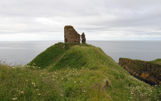
Forse Castle

Forse Castle is a ruined building dating from 1200 in the hamlet of Forse in the Caithness region in the Scottish council area of Highland. It is protected...

Nearby Amenities

Located within 500m of 58.313518,-3.4014224
Power: tower
Lat/Long: 58.3101848/-3.4060666
Power: tower
Lat/Long: 58.3133914/-3.4037973
Power: tower
Lat/Long: 58.3154846/-3.4022977
Power: tower
Lat/Long: 58.3179825/-3.4005292
The data included in this document is from www.openstreetmap.org. The data is made available under ODbL.

Have you been to Braehungie?

Leave your review of Braehungie below (or comments, questions and feedback).