Beckhead Moss

Downs, Moorland in Cumberland Allerdale

England

Beckhead Moss

Fallen tree beside Loweswater Low Fell <a href="https://www.geograph.org.uk/gridref/NY1322">NY1322</a> lies across the water. In the distance are Grasmoor <a href="https://www.geograph.org.uk/gridref/NY1720">NY1720</a> with Whiteside <a href="https://www.geograph.org.uk/gridref/NY1721">NY1721</a> to the left.
Fallen tree beside Loweswater Credit: Oliver Dixon

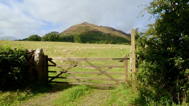
Beckhead Moss is a vast expanse of moorland located in the county of Cumberland, England. Situated on the outskirts of the small rural village of Beckhead, this area is known for its stunning natural beauty and unique ecosystem.

Covering an area of approximately 500 acres, Beckhead Moss is characterized by its rolling hills, heather-covered moorland, and scattered patches of woodland. The landscape is predominantly composed of peat, which has formed over thousands of years due to the accumulation of decaying vegetation.

The moss is home to a diverse range of flora and fauna, with many rare and protected species thriving within its boundaries. Visitors to Beckhead Moss may encounter species such as curlews, lapwings, and skylarks, as well as various species of butterflies and dragonflies. The area is also known for its vibrant wildflowers, including heather, bilberry, and cotton grass.

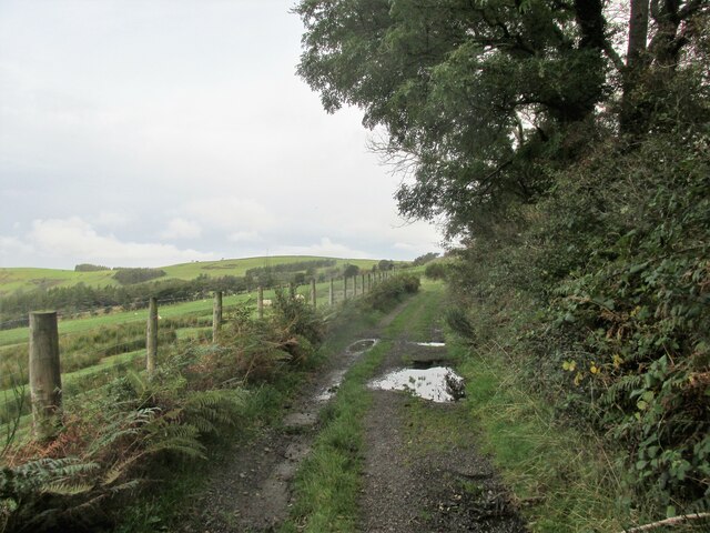
The moss is a haven for nature enthusiasts and provides ample opportunities for outdoor activities such as walking, bird-watching, and photography. Several walking trails have been established within the moss, allowing visitors to explore the area's natural wonders while respecting its delicate ecosystem.

Beckhead Moss is a designated Site of Special Scientific Interest (SSSI) due to its ecological importance and contribution to biodiversity. Efforts are made to maintain and preserve the moss's delicate balance, ensuring its continued existence for future generations to enjoy.

If you have any feedback on the listing, please let us know in the comments section below.

Beckhead Moss Images

Images are sourced within 2km of 54.593944/-3.3449778 or Grid Reference NY1322. Thanks to Geograph Open Source API. All images are credited.

Fallen tree beside Loweswater Low Fell <a href="https://www.geograph.org.uk/gridref/NY1322">NY1322</a> lies across the water. In the distance are Grasmoor <a href="https://www.geograph.org.uk/gridref/NY1720">NY1720</a> with Whiteside <a href="https://www.geograph.org.uk/gridref/NY1721">NY1721</a> to the left.
Fallen tree beside Loweswater
Low Fell NY1322 lies across the water. In the distance are Grasmoor NY1720 with Whiteside NY1721 to the left.
Fallen tree beside Loweswater
Footpath at Waterend Across marshy ground at the head of Loweswater. Darling Fell <a href="https://www.geograph.org.uk/gridref/NY1222">NY1222</a> across the valley.
Footpath at Waterend
Across marshy ground at the head of Loweswater. Darling Fell NY1222 across the valley.
Young Blackbird On a wall near Hudson Place.
Young Blackbird
On a wall near Hudson Place.
Hedgerow and fence above Loweswater
Driftwood beside Loweswater
The Goblin Tree Giant Sycamore in Holme Wood.
The Goblin Tree
Giant Sycamore in Holme Wood.
Small beach on the shores of Loweswater
Holme Wood Bothy Stone tent let out to holidaymakers by the National Trust. £500+ per week seems a high price to pay for minimal facilities, when compared with the cost of fully-equipped holiday cottages.
Holme Wood Bothy
Stone tent let out to holidaymakers by the National Trust. £500+ per week seems a high price to pay for minimal facilities, when compared with the cost of fully-equipped holiday cottages.
Giant Sweet Chestnut in Holme Wood On the shores of Loweswater.
Giant Sweet Chestnut in Holme Wood
On the shores of Loweswater.
Looking down Loweswater Low Fell <a href="https://www.geograph.org.uk/gridref/NY1322">NY1322</a> stands across the lake. In the distance are Grasmoor <a href="https://www.geograph.org.uk/gridref/NY1720">NY1720</a> with Whiteside <a href="https://www.geograph.org.uk/gridref/NY1721">NY1721</a> to the left.
Looking down Loweswater
Low Fell NY1322 stands across the lake. In the distance are Grasmoor NY1720 with Whiteside NY1721 to the left.
Wall at the end of Holme Wood Beside Loweswater.
Wall at the end of Holme Wood
Beside Loweswater.
The shores of Loweswater At the eastern end of Holme Wood.
The shores of Loweswater
At the eastern end of Holme Wood.
Lower end of Loweswater Low Fell <a href="https://www.geograph.org.uk/gridref/NY1322">NY1322</a> across the lake.
Lower end of Loweswater
Low Fell NY1322 across the lake.
Loweswater Fell
Loweswater Fell
Loweswater from the shoreside path. Lovely views across the lake.
Loweswater from the shoreside path.
Lovely views across the lake.
The lane from Myersyke. A walk to Low Fell.
The lane from Myersyke.
A walk to Low Fell.
The Mosser road. Old road that runs along the base of the fell.
The Mosser road.
Old road that runs along the base of the fell.
Show me another place!

Beckhead Moss is located at Grid Ref: NY1322 (Lat: 54.593944, Lng: -3.3449778)

Administrative County: Cumbria

District: Allerdale

Police Authority: Cumbria

What 3 Words

///hydration.sprays.regress. Near Cockermouth, Cumbria

Related Wikis

Low Fell (Lake District)

Low Fell is a fell in the English Lake District. It overlooks the lake of Loweswater to the south and to the north is bordered by its neighbour Fellbarrow...

Fellbarrow

Fellbarrow is a low hill in the north west of the English Lake District. It is not far from the town of Cockermouth, near to Loweswater and can most easily...

Loweswater

Loweswater is one of the smaller lakes in the English Lake District. The village of Loweswater is situated to the east of the lake. == Geography == The...

Thackthwaite

Thackthwaite is a village in Cumbria, England, from which hikers can climb Low Fell and Fellbarrow. The place-name contains thwaite ("clearing").A second...

Brackenthwaite, Buttermere

Brackenthwaite is a settlement and former civil parish, now in the parish of Buttermere, in the unitary authority area of Cumberland, in the ceremonial...

Loweswater (village)

Loweswater is a village and civil parish in the county of Cumbria, England. == Village == Historically part of Cumberland, the village lies between the...

Brackenthwaite Hows

Brackenthwaite Hows (also known as Lanthwaite Hill) is a hill in the Lake District of North West England. Crummock Water, Looking Towards Buttermere, a...

Mosser

Mosser is a village and former civil parish, 26 miles (42 km) south west of Carlisle, now in the parish of Blindbothel, in Allerdale district, in the county...

Nearby Amenities

Located within 500m of 54.593944,-3.3449778
Darling Fell
Ele: 392
Natural: peak
Source: npe
Lat/Long: 54.5901625/-3.3485135
Ford: yes
Source: survey
Lat/Long: 54.5900914/-3.343154
Loweswater Fell
Place: locality
Lat/Long: 54.5974318/-3.3486648
Beckhead Moss
Place: locality
Lat/Long: 54.594198/-3.3425485
Loftbarrow
Place: locality
Lat/Long: 54.597159/-3.3477888
Barrier: stile
Lat/Long: 54.590124/-3.3430434
Man Made: cairn
Lat/Long: 54.5905706/-3.3494852
The data included in this document is from www.openstreetmap.org. The data is made available under ODbL.

Have you been to Beckhead Moss?

Leave your review of Beckhead Moss below (or comments, questions and feedback).