Hodgson's Green

Downs, Moorland in Cumberland Copeland

England

Hodgson's Green

The path to Fell Brow A pleasant track with a wonderful view of the south-west Cumbrian coastline.

This photograph was taken during the Coronavirus (COVID-19) pandemic of 2020/21.
The path to Fell Brow Credit: James T M Towill

Hodgson's Green is a picturesque village located in the county of Cumberland, England. Situated amidst the serene and captivating Downs and Moorland landscapes, the village is known for its natural beauty and tranquility.

The village is characterized by its charming cottages, adorned with colorful gardens and enveloped by lush greenery. The surrounding countryside boasts rolling hills, heathlands, and vast expanses of wild moorland, offering breathtaking views that attract visitors from far and wide.

Hodgson's Green is a haven for nature enthusiasts and outdoor adventurers. The Downs provide ample opportunities for hiking, walking, and cycling, with numerous trails winding through the countryside, allowing visitors to immerse themselves in the stunning surroundings. The Moorland, on the other hand, is a haven for birdwatchers and wildlife enthusiasts, boasting a diverse range of flora and fauna.

The village itself is small but welcoming, with a close-knit community that takes pride in preserving the area's natural beauty and heritage. The local pub, The Green Inn, serves as a hub for socializing and is popular among both locals and tourists. The village also hosts an annual summer fair, which showcases local arts, crafts, and culinary delights.

Overall, Hodgson's Green in Cumberland offers a retreat from the hustle and bustle of everyday life, providing a peaceful and idyllic setting for those seeking solace in nature's embrace. Whether it's a leisurely stroll through the Downs or an adventure across the Moorland, this village is a true gem for nature lovers and a testament to the beauty of the English countryside.

If you have any feedback on the listing, please let us know in the comments section below.

Hodgson's Green Images

Images are sourced within 2km of 54.228014/-3.3344158 or Grid Reference SD1382. Thanks to Geograph Open Source API. All images are credited.

The path to Fell Brow A pleasant track with a wonderful view of the south-west Cumbrian coastline.

This photograph was taken during the Coronavirus (COVID-19) pandemic of 2020/21.
The path to Fell Brow
A pleasant track with a wonderful view of the south-west Cumbrian coastline. This photograph was taken during the Coronavirus (COVID-19) pandemic of 2020/21.
In Moor Gill A view back down to the fertile coastal farmland of this corner of Cumbria from the path leading to Black Combe.

This photograph was taken during the Coronavirus (COVID-19) pandemic of 2020/21.
In Moor Gill
A view back down to the fertile coastal farmland of this corner of Cumbria from the path leading to Black Combe. This photograph was taken during the Coronavirus (COVID-19) pandemic of 2020/21.
Bracken-lined Black Combe path In Moor Gill on the approach to Townend Knotts, time to look back and savour the view.  Walney Island can be noted in the centre distance of this shot.

This photograph was taken during the Coronavirus (COVID-19) pandemic of 2020/21.
Bracken-lined Black Combe path
In Moor Gill on the approach to Townend Knotts, time to look back and savour the view. Walney Island can be noted in the centre distance of this shot. This photograph was taken during the Coronavirus (COVID-19) pandemic of 2020/21.
Kirksanton level crossing
A5093 north of Hellpool Bridge
A5093 passing under power lines near Silecroft
A595 at Wood House Farm
The track to Giant's Grave Giant's Grave is two large standing stones
The track to Giant's Grave
Giant's Grave is two large standing stones
Giant's Grave With the hill Seaness (part of Black Combe) in the distance
Giant's Grave
With the hill Seaness (part of Black Combe) in the distance
St Mary's church at Whicham Starting point for a walk up Black Combe.
St Mary's church at Whicham
Starting point for a walk up Black Combe.
The Moorgill  path Start of the climb to Black Combe.
The Moorgill path
Start of the climb to Black Combe.
The path to Black Combe
Old Kirk A low stoney bank is all that is left of the early Medieval church that once stood upon this hillside above the village of Kirksanton.
Old Kirk
A low stoney bank is all that is left of the early Medieval church that once stood upon this hillside above the village of Kirksanton.
Paragliding the cliffs at Silecroft There were some 50 odd paragliders here taking part in the 2016 Lakes Charity Classic paragliding competition.
Paragliding the cliffs at Silecroft
There were some 50 odd paragliders here taking part in the 2016 Lakes Charity Classic paragliding competition.
Path by Fell Brow
Path by Fell Brow
Track near Kirkbank
Track near Kirkbank
Path up Moorgill
Path up Moorgill
Woodland south of Whitbeck Seen from a lay-by on the A595.
Woodland south of Whitbeck
Seen from a lay-by on the A595.
Show me another place!

Hodgson's Green is located at Grid Ref: SD1382 (Lat: 54.228014, Lng: -3.3344158)

Administrative County: Cumbria

District: Copeland

Police Authority: Cumbria

What 3 Words

///straws.dimension.voting. Near Haverigg, Cumbria

Related Wikis

Silecroft railway station

Silecroft is a railway station on the Cumbrian Coast Line, which runs between Carlisle and Barrow-in-Furness. The station, situated 19 miles (31 km) north...

Silecroft

The village of Silecroft in Cumbria, England, is in the parish of Whicham. It is situated between the towns of Millom and Bootle, and also neighbours the...

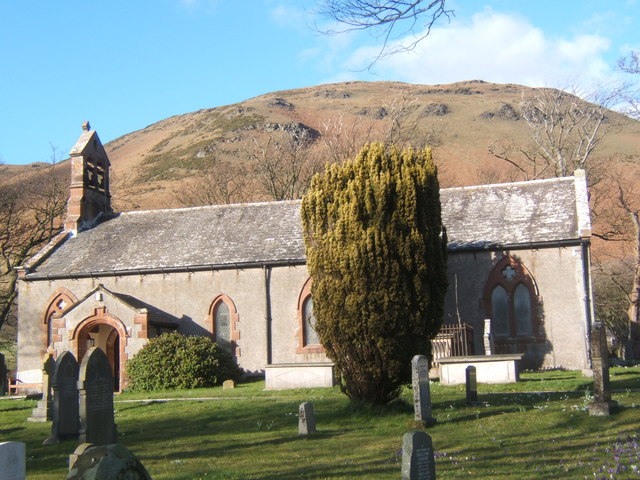
St Mary's Church, Whicham

St Mary's Church is on the A595 road in Whicham, Cumbria, England. It is an active Anglican parish church in the deanery of Calder, the archdeaconry of...

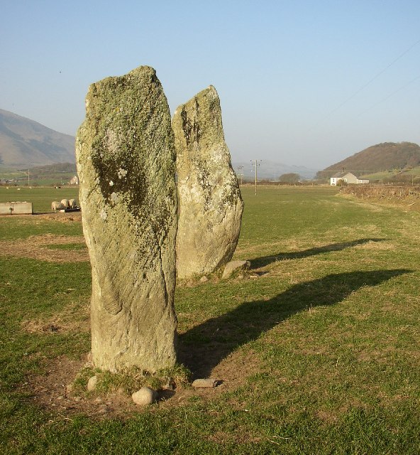
Giant's Grave, Cumbria

Giant's Grave (grid reference SD135810) are two standing stones at the foot of Black Combe in Cumbria, England. The smaller stone has three cup and ring...

Kirksanton

Kirksanton is a village on the A5093 road, in the Copeland district, in the county of Cumbria, England. Nearby settlements include the town of Millom,...

Whicham

Whicham is a hamlet and civil parish in Copeland, Cumbria, England. At the 2011 census the parish had a population of 382. The parish includes the villages...

Whitbeck, Cumbria

Whitbeck is a hamlet and former civil parish, now in the parish of Whicham, in the Copeland district, in the county of Cumbria, England. It was called...

RAF Millom

Royal Air Force Millom or more simply RAF Millom is a former Royal Air Force station located in Cumbria, England == History == Opened in January 1941 as...

Nearby Amenities

Located within 500m of 54.228014,-3.3344158
Silecroft
Naptan AtcoCode: 9100SILCRFT
Network: National Rail
Network Website: https://www.nationalrail.co.uk/stations/sic/
Network Wikidata: Q26334
Operator: Northern Rail
Operator Website: https://www.northernrailway.co.uk/stations/silecroft
Operator Wikidata: Q85789775
Public Transport: station
Railway: station
Ref Crs: SIC
Request Stop: yes
Source: npe
Train: yes
Wikidata: Q2587065
Wikipedia: en:Silecroft railway station
Lat/Long: 54.2260891/-3.3346818
Bus Stop
Hodgsons Green (W bound)
Bench: no
Bin: no
Lit: no
Local Ref: AT
Naptan AtcoCode: 090050291467
Naptan Bearing: W
Naptan BusStopType: CUS
Naptan CommonName: Hodgsons Green (W bound)
Naptan Indicator: at
Naptan Landmark: junction to Silecroft
Naptan NaptanCode: cumawgta
Naptan Street: A5093
Naptan Verified: no
Shelter: no
Source: naptan_import
Tactile Paving: no
Lat/Long: 54.2280358/-3.332242
Bus Stop
Hodgsons Green (E bound)
Bench: no
Bin: no
Lit: no
Naptan AtcoCode: 090050291707
Naptan Bearing: E
Naptan CommonName: Hodgsons Green (E bound)
Naptan Indicator: near
Naptan Landmark: junction to Silecroft
Naptan NaptanCode: cumawgtd
Naptan Street: A5093
Naptan Verified: no
Shelter: no
Source: naptan_import
Tactile Paving: no
Lat/Long: 54.2278744/-3.3306188
Power: tower
Lat/Long: 54.2284893/-3.3279451
Power: tower
Lat/Long: 54.2288778/-3.3375204
Power: tower
Lat/Long: 54.2286822/-3.332937
Power: tower
Lat/Long: 54.2290314/-3.3417341
Noexit: yes
Lat/Long: 54.2253446/-3.3365171
Barrier: lift_gate
Lat/Long: 54.2258346/-3.3343555
Parking
Parking: layby
Lat/Long: 54.2288848/-3.3343367
Post Box
Valley End
Post Box Type: lamp
Source: survey
Lat/Long: 54.2291125/-3.334724
Barrier: lift_gate
Lat/Long: 54.2259075/-3.3342678
Crossing Barrier: full
Crossing Light: yes
Railway: level_crossing
Lat/Long: 54.2258584/-3.3343268
Crossing Barrier: full
Crossing Light: yes
Railway: level_crossing
Lat/Long: 54.2258786/-3.3343026
Post Box
Post Box Type: wall
Lat/Long: 54.2263961/-3.3337199
Post Office
Silecroft Post Office
Addr City: Millom
Addr Housename: Silecroft Village Hall
Addr Postcode: LA18 5LP
Addr Street: Main Street
Addr Village: Silecroft
Brand: Post Office
Brand Wikidata: Q1783168
Opening Hours: Tu 09:00-12:00
Ref Pol Id: 97548
Source Addr: pol_branch_list_2018-01
Source Opening Hours: pol_branch_list_2018-01
Website: https://www.postoffice.co.uk/branch-finder/3854701/silecroft
Lat/Long: 54.2269285/-3.3325531
Power: pole
Lat/Long: 54.2296333/-3.3385456
Power: pole
Lat/Long: 54.2301686/-3.3396394
Give Way
Direction: forward
Lat/Long: 54.2294326/-3.3352321
Noexit: yes
Lat/Long: 54.2276259/-3.3309208
Murthwaite Green Trekking Centre
Website: https://www.murthwaitegreen.co.uk/
Lat/Long: 54.2271777/-3.3310112
Bowes House
Location: kiosk
Operator: Electricity North West
Power: substation
Ref: 616270
Substation: minor_distribution
Lat/Long: 54.224771/-3.3358181
Whicham
Place: village
Lat/Long: 54.2309502/-3.3333687
Barrier: kissing_gate
Lat/Long: 54.2284691/-3.3328751
Barrier: kissing_gate
Lat/Long: 54.2298306/-3.3318717
Historic: monument
Lat/Long: 54.2278182/-3.3319519
Noexit: yes
Lat/Long: 54.2266807/-3.3362125
Noexit: yes
Lat/Long: 54.2239768/-3.3361402
Noexit: yes
Lat/Long: 54.2238561/-3.3365805
Noexit: yes
Lat/Long: 54.226574/-3.3365406
Give Way
Direction: backward
Lat/Long: 54.2278952/-3.33151
Noexit: yes
Lat/Long: 54.2275021/-3.3326144
Noexit: yes
Lat/Long: 54.2277671/-3.3326546
Noexit: yes
Lat/Long: 54.227814/-3.3328775
Public Transport: stop_position
Railway: stop
Train: yes
Lat/Long: 54.2262127/-3.3349205
Public Transport: stop_position
Railway: stop
Train: yes
Lat/Long: 54.2260233/-3.3345488
Generator Method: photovoltaic
Generator Output Electricity: yes
Generator Source: solar
Generator Type: solar_photovoltaic_panel
Power: generator
Lat/Long: 54.2239637/-3.3362614
Generator Method: photovoltaic
Generator Output Electricity: yes
Generator Source: solar
Generator Type: solar_photovoltaic_panel
Power: generator
Lat/Long: 54.2255645/-3.3358267
Generator Method: photovoltaic
Generator Output Electricity: yes
Generator Source: solar
Generator Type: solar_photovoltaic_panel
Power: generator
Lat/Long: 54.2256305/-3.3351184
Silecroft
Place: village
Wikidata: Q7514340
Lat/Long: 54.2248741/-3.335417
Playground: swing
Lat/Long: 54.2261621/-3.3361631
Power: pole
Lat/Long: 54.2265105/-3.3290613
Power: pole
Lat/Long: 54.2300458/-3.3283172
Power: pole
Lat/Long: 54.2304407/-3.3297668
Power: pole
Lat/Long: 54.2308314/-3.3310263
Power: pole
Lat/Long: 54.2312695/-3.3325269
Power: pole
Lat/Long: 54.2308037/-3.3331232
Power: pole
Lat/Long: 54.2318875/-3.3316772
Power: pole
Lat/Long: 54.2257443/-3.3303385
Power: pole
Lat/Long: 54.2252024/-3.3312251
Power: pole
Lat/Long: 54.2248671/-3.3318813
Power: pole
Lat/Long: 54.2245411/-3.3325145
Power: pole
Lat/Long: 54.2240176/-3.3338357
Power: pole
Lat/Long: 54.2262657/-3.3330001
Power: pole
Lat/Long: 54.2258235/-3.3322718
Power: pole
Lat/Long: 54.2247015/-3.3305074
Power: pole
Lat/Long: 54.2271223/-3.3340626
Power: pole
Lat/Long: 54.2276992/-3.3350372
Power: pole
Lat/Long: 54.2282494/-3.3359801
Power: pole
Lat/Long: 54.2290196/-3.3372854
The data included in this document is from www.openstreetmap.org. The data is made available under ODbL.

Have you been to Hodgson's Green?

Leave your review of Hodgson's Green below (or comments, questions and feedback).