Aberogwr

Settlement in Glamorgan

Wales

Aberogwr

The mouth of the Ogmore River, Ogmore-by-Sea As seen from the B4524 road
The mouth of the Ogmore River, Ogmore-by-Sea Credit: John Baker

Aberogwr is a small village located in the county of Glamorgan, Wales. Situated on the southern coast of the country, it lies at the mouth of the River Ogwr, where it meets the Bristol Channel. The village is approximately 3 miles southwest of the town of Bridgend and enjoys a picturesque setting with stunning views of the surrounding countryside and coastline.

Aberogwr is known for its rich history, dating back to medieval times. The ruins of Ogmore Castle, a 12th-century fortress, can be found in the village, offering visitors a glimpse into the area's past. The castle played an important role in Welsh history and is a popular tourist attraction.

The village itself is small and quaint, with a close-knit community. It offers a range of amenities for residents and visitors, including a local pub, a village hall, and a few small shops. The nearby beach, Ogmore-by-Sea, is a popular spot for both locals and tourists, offering beautiful sandy shores and opportunities for water sports and coastal walks.

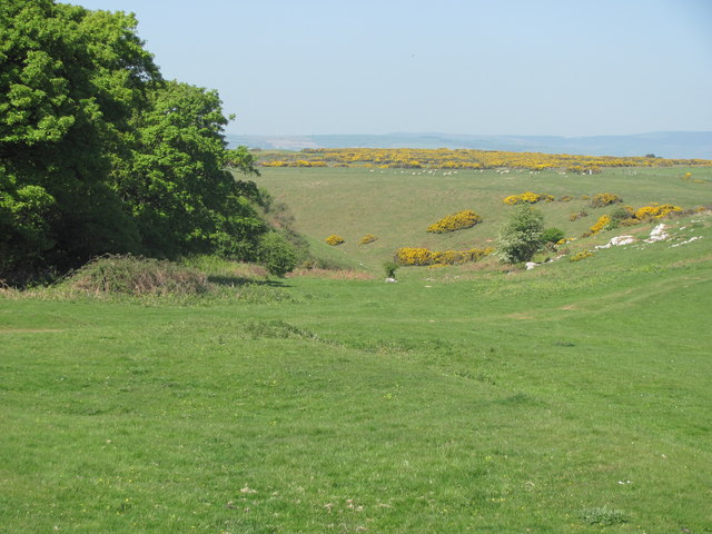
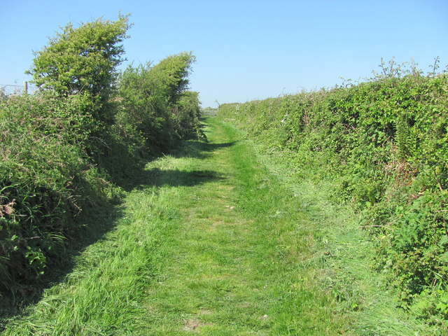
Nature enthusiasts will find Aberogwr to be a haven, with its proximity to the stunning Glamorgan Heritage Coastline. The area is home to a variety of wildlife, including seals, seabirds, and rare plant species. The coastal path provides breathtaking views and opportunities for exploring the natural beauty of the region.

Overall, Aberogwr is a charming village with a rich history, stunning natural surroundings, and a warm community atmosphere. It offers a peaceful retreat for those seeking a tranquil coastal experience in the heart of Wales.

If you have any feedback on the listing, please let us know in the comments section below.

Aberogwr Images

Images are sourced within 2km of 51.468172/-3.635452 or Grid Reference SS8675. Thanks to Geograph Open Source API. All images are credited.

The mouth of the Ogmore River, Ogmore-by-Sea As seen from the B4524 road
The mouth of the Ogmore River, Ogmore-by-Sea
As seen from the B4524 road
View from the top of Pant Mari Flanders A popular open space west of St Brides Major.
View from the top of Pant Mari Flanders
A popular open space west of St Brides Major.
Country lane through Heol-y-mynydd One of the many small roads in the area.
Country lane through Heol-y-mynydd
One of the many small roads in the area.
Bridleway west of Southerndown This grassy lane is quite wide at this point
Bridleway west of Southerndown
This grassy lane is quite wide at this point
Dunnock - Ogmore A singing male.
Dunnock - Ogmore
A singing male.
Common Whitethroat - Ogmore Considered to have been threatened with extinction in Britain because of droughts in the Sahel region of the Sahara this undistinguished warbler has bounced back and seems more common than many other birds of hedgerow and scrub in the region this summer.
Common Whitethroat - Ogmore
Considered to have been threatened with extinction in Britain because of droughts in the Sahel region of the Sahara this undistinguished warbler has bounced back and seems more common than many other birds of hedgerow and scrub in the region this summer.
River Ogmore A placid stretch of the river after it has tumbled its way toward the sea over a boulder strewn course. A few hundred metres or so further along it merges with the Ewenny which loses its identity to become the Ogmore in its entirety.
River Ogmore
A placid stretch of the river after it has tumbled its way toward the sea over a boulder strewn course. A few hundred metres or so further along it merges with the Ewenny which loses its identity to become the Ogmore in its entirety.
Part of Merthyr-mawr Warren dune system The dunes here are high, requiring effort to climb (for every one step forward you feel you are taking two steps back), but once youre up here there are good views to surrounding dunes and sight of many paths networking off through the dune system. There are lots of interesting grasses and sedges too, plus gorse and various saplings and trees.
Part of Merthyr-mawr Warren dune system
The dunes here are high, requiring effort to climb (for every one step forward you feel you are taking two steps back), but once youre up here there are good views to surrounding dunes and sight of many paths networking off through the dune system. There are lots of interesting grasses and sedges too, plus gorse and various saplings and trees.
Part of the dunes at Merthyr-mawr Warren Looking across the dunes towards the Ewenny / Ogmore valley. The coast is to the right.
Part of the dunes at Merthyr-mawr Warren
Looking across the dunes towards the Ewenny / Ogmore valley. The coast is to the right.
Part of Candleston Castle The castle is actually more of a fortified manor house dating from the 14th century rather than a more basic castle only. It was abandoned and ruined by the late 19th century, when the sand dunes encroached further. Today it is in the hands of Cadw but not in a proactive sense as the site seems in a basic state of maintenance.
Part of Candleston Castle
The castle is actually more of a fortified manor house dating from the 14th century rather than a more basic castle only. It was abandoned and ruined by the late 19th century, when the sand dunes encroached further. Today it is in the hands of Cadw but not in a proactive sense as the site seems in a basic state of maintenance.
Part of Candleston Castle The ruin of the tower where the main rooms were and where the main defence would have been staged from should the castle have been besieged.
Part of Candleston Castle
The ruin of the tower where the main rooms were and where the main defence would have been staged from should the castle have been besieged.
Fireplaces in the ruins of Candleston Castle The old great fireplaces are still in evidence here in the main tower.
Fireplaces in the ruins of Candleston Castle
The old great fireplaces are still in evidence here in the main tower.
Farm at Heol-y-mynydd An old farmhouse overlooks the road.
Farm at Heol-y-mynydd
An old farmhouse overlooks the road.
Cottages in Heol-y-mynydd A few cottages straggle along the lane.
Cottages in Heol-y-mynydd
A few cottages straggle along the lane.
Paddocks near Groes Farm A very horsey set up here with lots of happy and very healthy looking horses and ponies.
Paddocks near Groes Farm
A very horsey set up here with lots of happy and very healthy looking horses and ponies.
Sheltered path and bridleway near Southerndown The wind has shaped the hardy hawthorns here but the hedges provide shelter for man and beast against the elements along this old path.
Sheltered path and bridleway near Southerndown
The wind has shaped the hardy hawthorns here but the hedges provide shelter for man and beast against the elements along this old path.
Some of the extensive sand dunes at Merthyr Mawr
View across the sand dunes towards the car park Just part of the extensive sand dunes at Merthyr Mawr.
View across the sand dunes towards the car park
Just part of the extensive sand dunes at Merthyr Mawr.
Show me another place!

Aberogwr is located at Grid Ref: SS8675 (Lat: 51.468172, Lng: -3.635452)

Unitary Authority: The Vale of Glamorgan

Police Authority: South Wales

Also known as: Ogmore-by-Sea

What 3 Words

///slippers.fear.available. Near Merthyr Mawr, Bridgend

Related Wikis

River Ogmore

The River Ogmore (Welsh: Afon Ogwr) is a river in South Wales that is popular with anglers. It runs generally from north to south from the Ogmore Vale...

Ogmore-by-Sea

Ogmore-by-Sea (Welsh: Aberogwr, meaning "Mouth of the River Ogmore") is a seaside village in St Brides Major community in the Vale of Glamorgan, Wales...

Portobello House

Portobello House (also known formerly as Portobello Hotel) is a building on the bank of the River Ogmore, about half a mile up from the sea, near the estuary...

Southerndown Coast

Southerndown Coast is a Site of Special Scientific Interest (SSSI) in St Brides Major community, in the Vale of Glamorgan, South Wales. It forms part of...

Merthyr Mawr Sand Dunes

Merthyr Mawr Sand Dunes are sand dunes and a Site of Special Scientific Interest in Bridgend, south Wales. The village of Merthyr Mawr is nearby. The largest...

Candleston Castle

Candleston Castle (historically sometimes Candlestone Castle) is a 14th-century fortified manor house, in ruins since the 19th century. It is 0.75 miles...
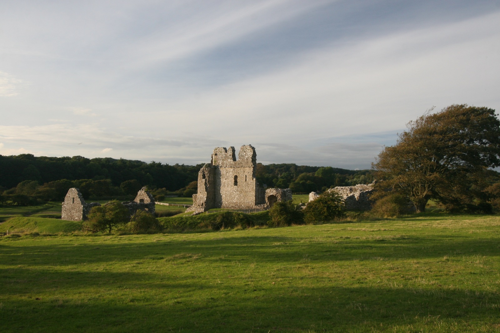
Ogmore Castle

Ogmore Castle (Welsh: Castell Ogwr) is a Grade I listed castle ruin located near the village of Ogmore-by-Sea, south of the town of Bridgend in Glamorgan...

Ogmore, Vale of Glamorgan

Ogmore (Welsh: Ogwr) is a village in the Vale of Glamorgan, Wales on the River Ogmore. It grew around the now ruined Ogmore Castle, built by the Normans...

Related Videos

WALES COAST PATH WALK - Ogmore-By-Sea & Dunraven Bay | UK Days Out

Take a walk along part of the Wales Coast Path as we walk this circular route from St Brides Major, visiting Wales coast locations ...

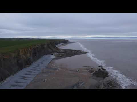
Walking Southerndown

Cinematic drone video of the fabulous coastline of Southerndown, South Wales.

Castle Tour of OGMORE CASTLE | Wales Walking Tour

Castle Tour of OGMORE CASTLE | Wales Walking Tour Wales Walking Tour No talking, just walking. Exploring the Welsh ...

Nearby Amenities

Located within 500m of 51.468172,-3.635452
Source: PGS
Lat/Long: 51.4710607/-3.6405457
Source: PGS
Lat/Long: 51.4707271/-3.63987
Source: PGS
Lat/Long: 51.4704999/-3.6393712
Source: PGS
Lat/Long: 51.470274/-3.6387951
Source: PGS
Lat/Long: 51.4699024/-3.6374968
Source: PGS
Lat/Long: 51.4697737/-3.6376052
Source: PGS
Lat/Long: 51.4695879/-3.638022
Source: PGS
Lat/Long: 51.468672/-3.6395439
Source: PGS
Lat/Long: 51.4683745/-3.6409
Source: PGS
Lat/Long: 51.4679509/-3.6418698
Source: PGS
Lat/Long: 51.4668128/-3.6416153
Source: PGS
Lat/Long: 51.4657561/-3.641212
Barrier: cattle_grid
Bicycle: yes
Foot: yes
Motorcar: yes
Motorcycle: yes
Lat/Long: 51.4706117/-3.6344182
Ogmore-by-Sea
Name Cy: Aberogwr
Place: village
Wikidata: Q3399956
Lat/Long: 51.463963/-3.6338591
Barrier: cattle_grid
Bicycle: yes
Foot: yes
Motorcar: yes
Motorcycle: yes
Lat/Long: 51.468469/-3.6374788
Barrier: bollard
Fixme: please clarify the type of barrier
Lat/Long: 51.466669/-3.6345614
Post Box
Collection Times: Mo-Fr 09:00; Sa 07:00
Operator: Royal Mail
Post Box Mounting: pier
Post Box Type: lamp
Ref: CF32 140D
Royal Cypher: EIIR
Royal Cypher Wikidata: Q33102113
Lat/Long: 51.4639816/-3.6344951
Direction: 170
Generator Method: photovoltaic
Generator Output Electricity: yes
Generator Solar Modules: 8
Generator Source: solar
Generator Type: solar_photovoltaic_panel
Location: roof
Power: generator
Lat/Long: 51.4680583/-3.6364354
Direction: 260
Generator Method: photovoltaic
Generator Output Electricity: yes
Generator Solar Modules: 6
Generator Source: solar
Generator Type: solar_photovoltaic_panel
Location: roof
Power: generator
Lat/Long: 51.4680167/-3.6365098
Direction: 255
Generator Method: photovoltaic
Generator Output Electricity: yes
Generator Solar Modules: 4
Generator Source: solar
Generator Type: solar_photovoltaic_panel
Location: roof
Power: generator
Lat/Long: 51.4670821/-3.6373376
Direction: 165
Generator Method: photovoltaic
Generator Output Electricity: yes
Generator Solar Modules: 8
Generator Source: solar
Generator Type: solar_photovoltaic_panel
Location: roof
Power: generator
Lat/Long: 51.4670954/-3.6372578
Direction: 255
Generator Method: photovoltaic
Generator Output Electricity: yes
Generator Solar Modules: 10
Generator Source: solar
Generator Type: solar_photovoltaic_panel
Location: roof
Power: generator
Lat/Long: 51.4662399/-3.6377513
Direction: S
Generator Method: photovoltaic
Generator Output Electricity: yes
Generator Solar Modules: 16
Generator Source: solar
Generator Type: solar_photovoltaic_panel
Location: roof
Power: generator
Lat/Long: 51.4639093/-3.637642
Direction: SSE
Generator Method: photovoltaic
Generator Output Electricity: yes
Generator Solar Modules: 20
Generator Source: solar
Generator Type: solar_photovoltaic_panel
Location: roof
Power: generator
Lat/Long: 51.4647076/-3.6365953
Direction: 165
Generator Method: photovoltaic
Generator Output Electricity: yes
Generator Solar Modules: 20
Generator Source: solar
Generator Type: solar_photovoltaic_panel
Location: roof
Power: generator
Lat/Long: 51.4645472/-3.6366382
Direction: 175
Generator Method: photovoltaic
Generator Output Electricity: yes
Generator Solar Modules: 20
Generator Source: solar
Generator Type: solar_photovoltaic_panel
Location: roof
Power: generator
Lat/Long: 51.464636/-3.6360696
Direction: S
Generator Method: photovoltaic
Generator Output Electricity: yes
Generator Solar Modules: 14
Generator Source: solar
Generator Type: solar_photovoltaic_panel
Location: roof
Power: generator
Lat/Long: 51.4636994/-3.6360441
Direction: S
Generator Method: photovoltaic
Generator Output Electricity: yes
Generator Solar Modules: 16
Generator Source: solar
Generator Type: solar_photovoltaic_panel
Location: roof
Power: generator
Lat/Long: 51.4639667/-3.636594
Drinking Water
Access: yes
Bottle: yes
Covered: no
Fee: no
Operator: Vale of Glamorgan County Borough Council
Wheelchair: yes
Lat/Long: 51.4661982/-3.6397985
The data included in this document is from www.openstreetmap.org. The data is made available under ODbL.

Have you been to Aberogwr?

Leave your review of Aberogwr below (or comments, questions and feedback).