Adie's Brae

Downs, Moorland in Dumfriesshire

Scotland

Adie's Brae

Path to Annanhead Hill The information board describes the Borders Forest Trust's Corehead project to restore habitat by replanting the slopes with native woodland - see <span class="nowrap"><a title="https://bordersforesttrust.org/wild-heart/corehead" rel="nofollow ugc noopener" href="https://bordersforesttrust.org/wild-heart/corehead">Link</a><img style="margin-left:2px;" alt="External link" title="External link - shift click to open in new window" src="https://s1.geograph.org.uk/img/external.png" width="10" height="10"/></span>.

The path is part of the Annandale Way loop up from Moffat to the highest point on Chalk Rig Edge and the source of the River Annan.
Path to Annanhead Hill Credit: Jim Barton

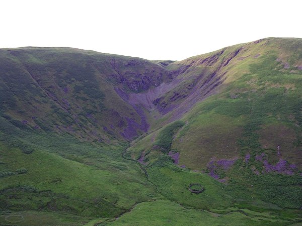
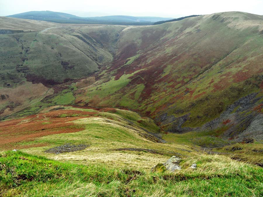
Adie's Brae is a picturesque area located in the region of Dumfriesshire, Scotland. Situated amidst tranquil downs and moorland landscapes, it is renowned for its natural beauty and stunning vistas.

The brae, meaning a hillside or slope in Scots dialect, offers magnificent panoramic views of the surrounding countryside. The downs are characterized by gently rolling hills covered in lush green grass, making it a haven for nature lovers and hikers. The moorland, on the other hand, features vast expanses of heather and peat bogs, providing a unique habitat for various bird species and other wildlife.

Adie's Brae is a popular destination for outdoor enthusiasts and those seeking solace in nature. It offers numerous walking trails and paths that meander through the ups and downs of the landscape, allowing visitors to explore its diverse terrain. The area is also known for its vibrant flora, with wildflowers adorning the slopes during the summer months.

In addition to its natural offerings, Adie's Brae has historical significance as well. It is believed to have been named after a local farmer or landowner, adding a touch of heritage to the area. The nearby towns and villages provide amenities and accommodations for visitors, making it an ideal base for exploring Dumfriesshire and its surrounding attractions.

Overall, Adie's Brae presents a captivating blend of downs, moorland, and breathtaking scenery, making it a must-visit destination for those seeking to immerse themselves in the beauty of the Scottish countryside.

If you have any feedback on the listing, please let us know in the comments section below.

Adie's Brae Images

Images are sourced within 2km of 55.389529/-3.4705922 or Grid Reference NT0611. Thanks to Geograph Open Source API. All images are credited.

Path to Annanhead Hill The information board describes the Borders Forest Trust's Corehead project to restore habitat by replanting the slopes with native woodland - see <span class="nowrap"><a title="https://bordersforesttrust.org/wild-heart/corehead" rel="nofollow ugc noopener" href="https://bordersforesttrust.org/wild-heart/corehead">Link</a><img style="margin-left:2px;" alt="External link" title="External link - shift click to open in new window" src="https://s1.geograph.org.uk/img/external.png" width="10" height="10"/></span>.

The path is part of the Annandale Way loop up from Moffat to the highest point on Chalk Rig Edge and the source of the River Annan.
Path to Annanhead Hill
The information board describes the Borders Forest Trust's Corehead project to restore habitat by replanting the slopes with native woodland - see LinkExternal link. The path is part of the Annandale Way loop up from Moffat to the highest point on Chalk Rig Edge and the source of the River Annan.
Devil's Beef Tub from Annanhead Hill The deep-cut bowl of the Devil's Beef Tub continues round to the right in this view towards Upper Annandale with the A701 road rounding the shoulder of Ericstane Hill above a steep 150m slope below.
Devil's Beef Tub from Annanhead Hill
The deep-cut bowl of the Devil's Beef Tub continues round to the right in this view towards Upper Annandale with the A701 road rounding the shoulder of Ericstane Hill above a steep 150m slope below.
Great Hill and Strait Step The steep west side of Great Hill is well seen from Annanhead Hill. The Strait Step is the precarious-looking path traversing the face, on a route connecting the former farm at Earlshaugh with Corehead in the valley below.
Great Hill and Strait Step
The steep west side of Great Hill is well seen from Annanhead Hill. The Strait Step is the precarious-looking path traversing the face, on a route connecting the former farm at Earlshaugh with Corehead in the valley below.
Forestry at Annanhead Moss The A701 road between Edinburgh and Dumfries is in the foreground, seen from Annanhead Hill.
Forestry at Annanhead Moss
The A701 road between Edinburgh and Dumfries is in the foreground, seen from Annanhead Hill.
Viewpoint bench, Annanhead Hill (2) A clear sunny day on which to enjoy the extensive views from the highest parts of the Annandale Way. The bench is inscribed 'Annandale Way Viewpoints'.

Compare with <a href="https://www.geograph.org.uk/photo/4162483">NT0513 : Viewpoint bench, Annanhead Hill</a>.
Viewpoint bench, Annanhead Hill (2)
A clear sunny day on which to enjoy the extensive views from the highest parts of the Annandale Way. The bench is inscribed 'Annandale Way Viewpoints'. Compare with NT0513 : Viewpoint bench, Annanhead Hill.
Descending Peat Knowe On the ridge eastwards towards the notch at the start of the Strait Step pass.
Descending Peat Knowe
On the ridge eastwards towards the notch at the start of the Strait Step pass.
Fence on Great Hill The Annandale Way follows the fence skirting to the north of the 466m summit of Great Hill.
Fence on Great Hill
The Annandale Way follows the fence skirting to the north of the 466m summit of Great Hill.
Annanhead Hill Trig Point Flush Bracket S5678
Footpath marker Annandale Way
The Devil's Beef Tub
Moffat Water Community Hall
March Burn and grassland near the A701
Great Hill View from A701.
Great Hill
View from A701.
Wet day at Ericstane Rain and low cloud at the farm in Upper Annandale. The track continues to Corehead below the Devil's Beef Tub.
Wet day at Ericstane
Rain and low cloud at the farm in Upper Annandale. The track continues to Corehead below the Devil's Beef Tub.
Track to Corehead The bumpy track for the final stretch to Corehead; the dramatic slopes of the Devil's Beef Tub are invisible today in very low cloud.
Track to Corehead
The bumpy track for the final stretch to Corehead; the dramatic slopes of the Devil's Beef Tub are invisible today in very low cloud.
Farm track to Corehead A fine example of a dreich day in Upper Annandale with steady light rain and the cloud base down to almost 200m.
Farm track to Corehead
A fine example of a dreich day in Upper Annandale with steady light rain and the cloud base down to almost 200m.
River Annan below the Devil's Beef Tub The Tweedhope Burn is joined by the burn draining the Devil's Beef Tub, forming the River Annan on its journey to the Solway Firth.
River Annan below the Devil's Beef Tub
The Tweedhope Burn is joined by the burn draining the Devil's Beef Tub, forming the River Annan on its journey to the Solway Firth.
Groundworks at Corehead Corehead farm was purchased in 2009 by Borders Forest Trust to demonstrate how farming and restoration of woodland can coexist. More background and detail can be found at the Trust's website <span class="nowrap"><a title="https://bordersforesttrust.org/wild-heart/corehead" rel="nofollow ugc noopener" href="https://bordersforesttrust.org/wild-heart/corehead">Link</a><img style="margin-left:2px;" alt="External link" title="External link - shift click to open in new window" src="https://s1.geograph.org.uk/img/external.png" width="10" height="10"/></span>.

The low-lying area shown here has drainage ditches and ponds in construction.
Groundworks at Corehead
Corehead farm was purchased in 2009 by Borders Forest Trust to demonstrate how farming and restoration of woodland can coexist. More background and detail can be found at the Trust's website LinkExternal link. The low-lying area shown here has drainage ditches and ponds in construction.
Show me another place!

Adie's Brae is located at Grid Ref: NT0611 (Lat: 55.389529, Lng: -3.4705922)

Unitary Authority: Dumfries and Galloway

Police Authority: Dumfries and Galloway

What 3 Words

///rebounder.keener.juggles. Near Moffat, Dumfries & Galloway

Nearby Locations

Adie's Brae

Related Wikis

Crown of Scotland (hill)

The Crown of Scotland is a hill in the Scottish Borders, Scotland. At a relatively small elevation from the surrounding peaks, it is situated to the north...

Devil's Beef Tub

The Devil's Beef Tub (Marquis of Annandale's Beef-Tub, Beef-Stand, MacCleran's Loup) is a deep, dramatic hollow in the hills north of the Scottish town...

Annanhead Hill

Annanhead Hill is a 478-metre (1,568 ft) summit in the Moffat Hills of Scotland. It lies on the boundary between the Scottish Borders and Dumfries and...

Greenhillstairs

Greenhillstairs is the steep B719 road north of Moffat in Dumfries and Galloway, Scotland. The road, about 3 miles long, leaves the A701 Moffat to Edinburgh...

Nearby Amenities

Located within 500m of 55.389529,-3.4705922
Power: pole
Lat/Long: 55.3876622/-3.4643724
Power: pole
Lat/Long: 55.3885714/-3.4646186
Power: pole
Lat/Long: 55.389315/-3.4648288
Power: pole
Lat/Long: 55.3900962/-3.4650481
Power: pole
Lat/Long: 55.3908245/-3.4652703
Power: pole
Lat/Long: 55.3915664/-3.465036
Power: pole
Lat/Long: 55.3923194/-3.4647838
The data included in this document is from www.openstreetmap.org. The data is made available under ODbL.

Have you been to Adie's Brae?

Leave your review of Adie's Brae below (or comments, questions and feedback).