Borland Moss

Downs, Moorland in Lanarkshire

Scotland

Borland Moss

Long shadow and decaying trig point on Black Mount A photo in late afternoon the day before the clocks went back, with the main group of the Pentland Hills in the distance.
Long shadow and decaying trig point on Black Mount Credit: Alan O'Dowd

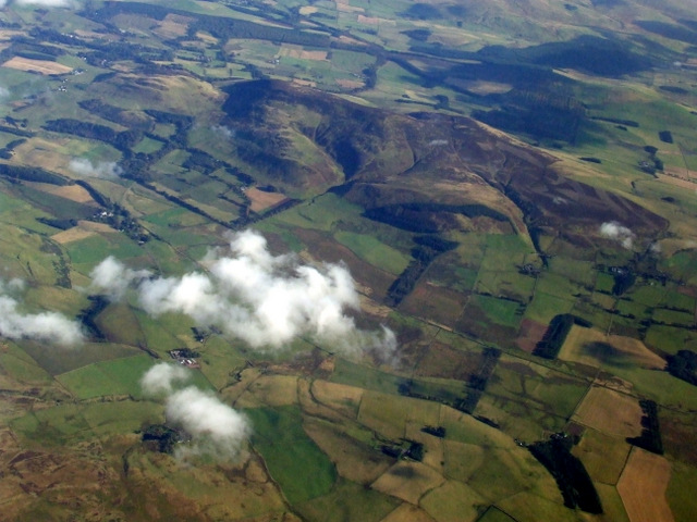
Borland Moss is a region located in the county of Lanarkshire, Scotland. Nestled within a rural landscape, it is characterized by its vast expanses of downs and moorland. The area is known for its picturesque beauty, with rolling hills and open fields that provide a peaceful and tranquil atmosphere.

The downs in Borland Moss are wide, open spaces covered in grasses and heathers. They offer stunning panoramic views of the surrounding countryside, making it a popular destination for nature lovers and hikers. The moorland, on the other hand, is characterized by its wet and boggy terrain, dominated by heather and peat moss. This unique ecosystem supports a variety of plant and animal species, including birds, insects, and small mammals.

In addition to its natural beauty, Borland Moss has a rich history. The area was once used for farming, with evidence of agricultural activity dating back centuries. Old stone walls and ruins can still be found, serving as reminders of the area's past.

While the region is predominantly rural, there are a few small settlements scattered throughout Borland Moss. These settlements consist of traditional cottages and farms, adding to the charm and character of the area.

Overall, Borland Moss offers a serene and idyllic escape from the bustling city life. Its downs and moorland provide a stunning backdrop for outdoor activities and a chance to immerse oneself in nature's beauty. Whether it's exploring the vast open spaces or discovering the area's rich history, Borland Moss is a destination that appeals to those seeking tranquility and a connection with the natural world.

If you have any feedback on the listing, please let us know in the comments section below.

Borland Moss Images

Images are sourced within 2km of 55.708551/-3.491755 or Grid Reference NT0647. Thanks to Geograph Open Source API. All images are credited.

Long shadow and decaying trig point on Black Mount A photo in late afternoon the day before the clocks went back, with the main group of the Pentland Hills in the distance.
Long shadow and decaying trig point on Black Mount
A photo in late afternoon the day before the clocks went back, with the main group of the Pentland Hills in the distance.
Eroding trig point on Black Mount This trig seems to have been eroding from the base for many years.
Eroding trig point on Black Mount
This trig seems to have been eroding from the base for many years.
Black Mount View from Ewe Hill.
Black Mount
View from Ewe Hill.
Near the top of Dunsyre Hill A view towards distant Mendick Hill with the small rocky outcrop on which Dunsyre Hill's summit cairn sits visible on the right-hand side of the photo.
Near the top of Dunsyre Hill
A view towards distant Mendick Hill with the small rocky outcrop on which Dunsyre Hill's summit cairn sits visible on the right-hand side of the photo.
Summit cairn on Dunsyre Hill This small pile of stones sits on top of the remains of a prehistoric cairn. For more information see: <span class="nowrap"><a title="https://canmore.org.uk/site/48824/dunsyre-hill" rel="nofollow ugc noopener" href="https://canmore.org.uk/site/48824/dunsyre-hill">Link</a><img style="margin-left:2px;" alt="External link" title="External link - shift click to open in new window" src="https://s1.geograph.org.uk/img/external.png" width="10" height="10"/></span>

Although only 401 metres above sea level, this summit commands great views.
Summit cairn on Dunsyre Hill
This small pile of stones sits on top of the remains of a prehistoric cairn. For more information see: LinkExternal link Although only 401 metres above sea level, this summit commands great views.
Steep descent off Dunsyre Hill Although a small, compact hill, the southern slopes of Dunsyre Hill are steep in places with rock outcrops.

The farm buildings at Easton are visible in the distance, with Mendick Hill beyond.
Steep descent off Dunsyre Hill
Although a small, compact hill, the southern slopes of Dunsyre Hill are steep in places with rock outcrops. The farm buildings at Easton are visible in the distance, with Mendick Hill beyond.
View across the southern flank of Dunsyre Hill The low winter sun shows up the rig-and-furrow pattern of medieval to post-medieval cultivation terraces on the east and south-east side of this small, steep hill.

For more information, see <span class="nowrap"><a title="https://canmore.org.uk/site/48821/dunsyre-hill" rel="nofollow ugc noopener" href="https://canmore.org.uk/site/48821/dunsyre-hill">Link</a><img style="margin-left:2px;" alt="External link" title="External link - shift click to open in new window" src="https://s1.geograph.org.uk/img/external.png" width="10" height="10"/></span>
View across the southern flank of Dunsyre Hill
The low winter sun shows up the rig-and-furrow pattern of medieval to post-medieval cultivation terraces on the east and south-east side of this small, steep hill. For more information, see LinkExternal link
Anston Farm Seen from the track to Little Sparta. The crags of Dunsyre Hill <a href="https://www.geograph.org.uk/gridref/NT0648">NT0648</a> can be seen beyond.
Anston Farm
Seen from the track to Little Sparta. The crags of Dunsyre Hill NT0648 can be seen beyond.
Replanting by the Anston Burn A replanted area after tree felling - compare with <a href="https://www.geograph.org.uk/photo/2269961">NT0548 : Felled woodland</a> taken in winter this year.
Replanting by the Anston Burn
A replanted area after tree felling - compare with NT0548 : Felled woodland taken in winter this year.
Entering Dunsyre from the west Entering this small village on the minor road from Newbigging.
Entering Dunsyre from the west
Entering this small village on the minor road from Newbigging.
Tunnel through the old railway embankment, Dunsyre The Dunsyre Burn flows through this tunnel under the now dismantled railway line from Dolphinton to Carstairs.
Tunnel through the old railway embankment, Dunsyre
The Dunsyre Burn flows through this tunnel under the now dismantled railway line from Dolphinton to Carstairs.
Cutting silage at Anston Farm Making the most of a settled hot sunny day, viewed from the path between Boston Cottage and Little Sparta.
Cutting silage at Anston Farm
Making the most of a settled hot sunny day, viewed from the path between Boston Cottage and Little Sparta.
On the track below Little Sparta Sheep and cattle farming on the more productive land nearer the valley floor. Black Mount is in the background.
On the track below Little Sparta
Sheep and cattle farming on the more productive land nearer the valley floor. Black Mount is in the background.
Black Mount Not so aptly named today, the snow is deep enough to cover the heather which is responsible for the hill's name.  A view from the north side of Tinto.
Black Mount
Not so aptly named today, the snow is deep enough to cover the heather which is responsible for the hill's name. A view from the north side of Tinto.
Field of sheep, Anston A farm at the south end of the Pentland Hills near Dunsyre.
Field of sheep, Anston
A farm at the south end of the Pentland Hills near Dunsyre.
A track across the Pentland Hills The access road to Stonypath (Little Sparta Gardens) continues as a path over to the Lang Whang.
A track across the Pentland Hills
The access road to Stonypath (Little Sparta Gardens) continues as a path over to the Lang Whang.
Black Mount from the air Viewed across Borland Moss from a Prague bound flight from Edinburgh.
Black Mount from the air
Viewed across Borland Moss from a Prague bound flight from Edinburgh.
Borland Moss from the air The South Medwin Burn and the former Caledonian Railway Dolphinton Branch Line from Carstairs can be seen running vertically through the photo.
Borland Moss from the air
The South Medwin Burn and the former Caledonian Railway Dolphinton Branch Line from Carstairs can be seen running vertically through the photo.
Show me another place!

Borland Moss is located at Grid Ref: NT0647 (Lat: 55.708551, Lng: -3.491755)

Unitary Authority: South Lanarkshire

Police Authority: Lanarkshire

What 3 Words

///plunger.motoring.loss. Near Carnwath, South Lanarkshire

Nearby Locations

Borland Moss Bog Wood

Related Wikis

Walston, South Lanarkshire

Walston is a hamlet in the middle of black mount area of South Lanarkshire, Scotland. == History == Patrick Molleson in the Old Statistical Account records...

Dunsyre

Dunsyre (Scottish Gaelic: Dùn Saghair) is a village in South Lanarkshire, Scotland. It is 10 kilometres (6 mi) from Carnwath. Dunsyre is associated with...

Dunsyre railway station

Dunsyre railway station served the village of Dunsyre, South Lanarkshire, Scotland from 1867 to 1945 on the Dolphinton branch. == History == The station...

Little Sparta

Little Sparta is a garden at Dunsyre in the Pentland Hills in South Lanarkshire, Scotland, created by artist and poet Ian Hamilton Finlay and his wife...

Have you been to Borland Moss?

Leave your review of Borland Moss below (or comments, questions and feedback).