Fore Brae

Downs, Moorland in Lanarkshire

Scotland

Fore Brae

Risingclaw Heights A ploughed windfarm road along the Tweed/Clyde watershed. The Peeblesshire side is forested.
Risingclaw Heights Credit: Richard Webb

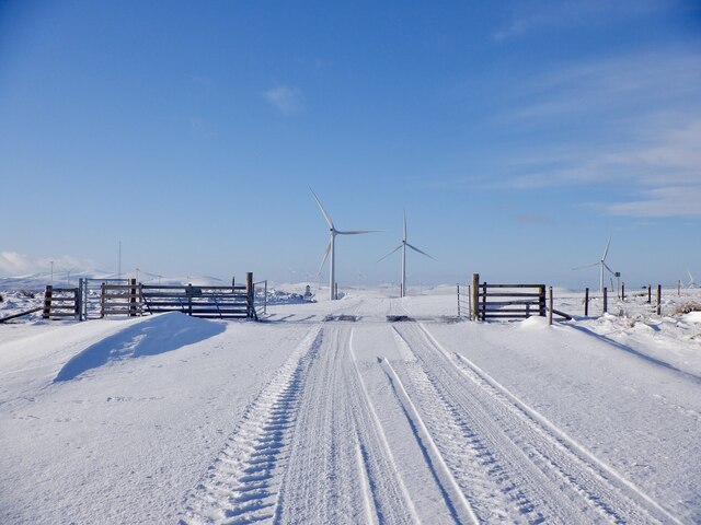
Fore Brae is a picturesque area located in Lanarkshire, Scotland. Situated in the southern part of the county, it is known for its stunning natural beauty and diverse landscapes, including downs and moorland.

The downs of Fore Brae are characterized by gentle slopes and rolling hills. These grassy areas are perfect for outdoor activities such as walking, hiking, and picnicking. The downs offer panoramic views of the surrounding countryside, with lush green fields and scattered trees creating a tranquil setting.

In contrast, the moorland of Fore Brae presents a more rugged and wild environment. This area is characterized by heather-covered hills, rocky outcrops, and peat bogs. Moorland is known for its unique flora and fauna, including species such as heather, cotton grass, and grouse. The moorland offers a unique opportunity for nature enthusiasts to explore and appreciate the beauty of this untamed landscape.

Fore Brae is also home to a variety of wildlife, including rabbits, hares, and a diverse range of bird species. Nature lovers can spot birds of prey, such as kestrels and buzzards, soaring above the downs and moorland.

Visitors to Fore Brae can enjoy the tranquility and peacefulness of the countryside while immersing themselves in the natural wonders of Lanarkshire. Whether it's a leisurely walk through the downs or an adventurous hike across the moorland, Fore Brae offers something for everyone seeking to connect with nature.

If you have any feedback on the listing, please let us know in the comments section below.

Fore Brae Images

Images are sourced within 2km of 55.472367/-3.5499466 or Grid Reference NT0220. Thanks to Geograph Open Source API. All images are credited.

Risingclaw Heights A ploughed windfarm road along the Tweed/Clyde watershed. The Peeblesshire side is forested.
Risingclaw Heights
A ploughed windfarm road along the Tweed/Clyde watershed. The Peeblesshire side is forested.
March gate, Black Dod Entering Lanarkshire on the wind farm road. An enjoyable but windchill affected run on the fatbike.
March gate, Black Dod
Entering Lanarkshire on the wind farm road. An enjoyable but windchill affected run on the fatbike.
Black Dod summit
Black Dod summit
Clyde Wind Farm View south from Black Dod
Clyde Wind Farm
View south from Black Dod
Turbine on Black Dod
Road and turbine, Broad Hill Looking towards the Lowther Hills through the Clyde Wind Farm.
Road and turbine, Broad Hill
Looking towards the Lowther Hills through the Clyde Wind Farm.
Mast, Clyde Wind Farm On Broad Hill
Mast, Clyde Wind Farm
On Broad Hill
Black Cleuch Clyde Wind Farm
Black Cleuch
Clyde Wind Farm
Turbines, Yearngill Head
Wind turbines on Bank and Yearngill Head Part of the Clyde Wind Farm, one of the largest in Europe, which has covered some 47.5 square kilometres of these hills with more than 150 turbines and more than 100km of tracks.
Wind turbines on Bank and Yearngill Head
Part of the Clyde Wind Farm, one of the largest in Europe, which has covered some 47.5 square kilometres of these hills with more than 150 turbines and more than 100km of tracks.
The south-eastern arm of Camps Reservoir Midge Gill drains into the reservoir here, and in the distance one of the new wind turbines going up on the hills between here and Tweeddale is under construction on the hillside.
The south-eastern arm of Camps Reservoir
Midge Gill drains into the reservoir here, and in the distance one of the new wind turbines going up on the hills between here and Tweeddale is under construction on the hillside.
Wind turbines on Yearngill Head Miles of new roads have been bulldozed on these hills as part of the 152 turbine  Clyde Wind Farm, and there is a 54 turbine extension currently under construction.

It will be interesting to see how future generations view these developments with the benefit of hindsight - whether the environmental benefits of electricity generation in this way outweigh the destructive nature and huge expense of their construction.
Wind turbines on Yearngill Head
Miles of new roads have been bulldozed on these hills as part of the 152 turbine Clyde Wind Farm, and there is a 54 turbine extension currently under construction. It will be interesting to see how future generations view these developments with the benefit of hindsight - whether the environmental benefits of electricity generation in this way outweigh the destructive nature and huge expense of their construction.
Upper reaches of the Camps Water The burn is dammed further downstream to create the Camps Reservoir.
Upper reaches of the Camps Water
The burn is dammed further downstream to create the Camps Reservoir.
Kame and wind turbines by the Hilshie Burn The mound in the middle ground looks like a kame - a mound of material deposited on the ground during glacial retreat.
Kame and wind turbines by the Hilshie Burn
The mound in the middle ground looks like a kame - a mound of material deposited on the ground during glacial retreat.
Rickety bridge on the Camps Water There is a choice of two shoogly bridges to cross on near the sheds at Campshead, which stand on the site of a former farm steading called Whitecamp.
Rickety bridge on the Camps Water
There is a choice of two shoogly bridges to cross on near the sheds at Campshead, which stand on the site of a former farm steading called Whitecamp.
Track between Campshead and Campshead The house in the middle ground is named Campshead, but so is the collection of buildings just behind the photographer's position here, which was the site of a farm called Whitecamp on older maps.
Track between Campshead and Campshead
The house in the middle ground is named Campshead, but so is the collection of buildings just behind the photographer's position here, which was the site of a farm called Whitecamp on older maps.
Rough grazing below Kneesend Wood This track leads round the Camps Reservoir.
Rough grazing below Kneesend Wood
This track leads round the Camps Reservoir.
Camps Reservoir track at Campshead The massive Clyde Wind Farm development has led to wind turnbines being built on most of the hills surrounding the reservoir.
Camps Reservoir track at Campshead
The massive Clyde Wind Farm development has led to wind turnbines being built on most of the hills surrounding the reservoir.
Show me another place!

Fore Brae is located at Grid Ref: NT0220 (Lat: 55.472367, Lng: -3.5499466)

Unitary Authority: South Lanarkshire

Police Authority: Lanarkshire

What 3 Words

///hairstyle.pianists.marmalade. Near Biggar, South Lanarkshire

Related Wikis

Hawkshaw, Scottish Borders

Hawkshaw is a pair of semi-detached houses on the River Tweed, two miles southwest of Tweedsmuir in the Scottish Borders. Historically part of Peeblesshire...

Gathersnow Hill

Gathersnow Hill is a hill in the Culter Hills range, part of the Southern Uplands of Scotland. It lies west of the village of Tweedsmuir on the border...
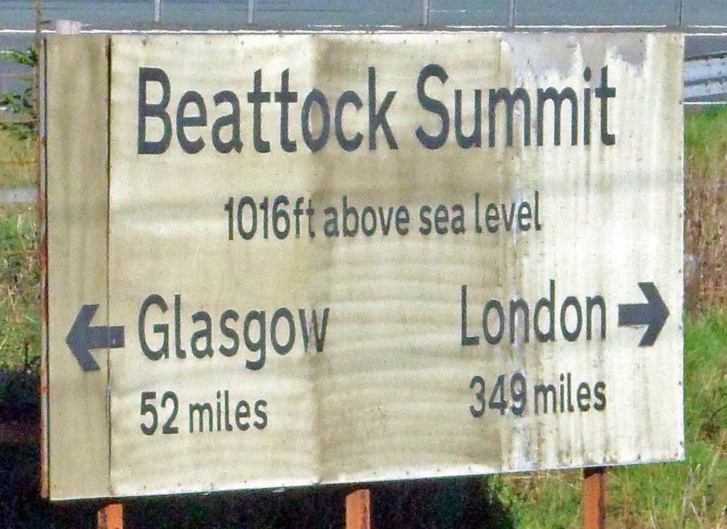
Beattock Summit

Beattock Summit is the highest point of the West Coast Main Line (WCML) railway and of the A74(M) motorway as they cross between Dumfries and Galloway...

Crawford railway station (Scotland)

Crawford railway station was a station which served the village of Crawford, near Abington, in the Scottish county of South Lanarkshire. It was served...

Have you been to Fore Brae?

Leave your review of Fore Brae below (or comments, questions and feedback).