Pillavins Moors

Downs, Moorland in Devon North Devon

England

Pillavins Moors

South Molton The centre of South Molton, looking west. The building with the clock tower is the town hall and pannier market. The brick building in the distance is the post office.
South Molton Credit: Dave Bushell

The requested URL returned error: 429 Too Many Requests

If you have any feedback on the listing, please let us know in the comments section below.

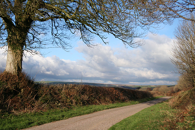
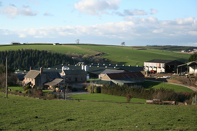
Pillavins Moors Images

Images are sourced within 2km of 51.025968/-3.81281 or Grid Reference SS7226. Thanks to Geograph Open Source API. All images are credited.

South Molton The centre of South Molton, looking west. The building with the clock tower is the town hall and pannier market. The brick building in the distance is the post office.
South Molton
The centre of South Molton, looking west. The building with the clock tower is the town hall and pannier market. The brick building in the distance is the post office.
Pathfields Business Park, South Molton
House with bridge over disused railway near Rawstone Moors
Silage  bales stored near Rawstone
Silage bales stored near Rawstone
The Mill Inn at Bish Mill
South Molton: site of East Street tannery Converted tanyard buildings: the low building with the grey roof now houses a car repair shop. Looking south. A much larger range of old tannery structures stands closer to East Street, behind the camera, now used for other purposes
South Molton: site of East Street tannery
Converted tanyard buildings: the low building with the grey roof now houses a car repair shop. Looking south. A much larger range of old tannery structures stands closer to East Street, behind the camera, now used for other purposes
South Molton fire station South Molton fire station, North Street, South Molton, Devon has recently been refurbished and enlarged by the Devon Fire & Rescue Service.
South Molton fire station
South Molton fire station, North Street, South Molton, Devon has recently been refurbished and enlarged by the Devon Fire & Rescue Service.
Bishop’s Nympton: Bish Mill A disused watermill which was once powered by a leat from the river Yeo. Looking north. The Mill Inn is named after this building
Bishop’s Nympton: Bish Mill
A disused watermill which was once powered by a leat from the river Yeo. Looking north. The Mill Inn is named after this building
Bishop’s Nympton: On Gorton Hill The eastern link from South Molton to the North Devon Link Road, Tiverton and the M5 Motorway. Looking east
Bishop’s Nympton: On Gorton Hill
The eastern link from South Molton to the North Devon Link Road, Tiverton and the M5 Motorway. Looking east
Bishop’s Nympton: towards South Molton Looking west near Windwhistle Farm
Bishop’s Nympton: towards South Molton
Looking west near Windwhistle Farm
Bishop’s Nympton: the North Devon Link Road Looking south east in the Tiverton direction
Bishop’s Nympton: the North Devon Link Road
Looking south east in the Tiverton direction
Bishop’s Nympton: Drewstone Moors Looking east from Bicknor Bridge. The Taunton-Barnstaple railway line once ran here and its course is defined by the fencing beyond the trees. Looking east
Bishop’s Nympton: Drewstone Moors
Looking east from Bicknor Bridge. The Taunton-Barnstaple railway line once ran here and its course is defined by the fencing beyond the trees. Looking east
Bishop’s Nympton: towards Windwhistle Farm Seen from Mole bridge looking east-north-east
Bishop’s Nympton: towards Windwhistle Farm
Seen from Mole bridge looking east-north-east
South Molton: Higher Mole Mills Looking north. Unlike Lower Mole Mills this building still retains some of its original characteristics such as the bell above the roof. These were both woollen mills in the 19th century and were powered by leats from the river Mole
South Molton: Higher Mole Mills
Looking north. Unlike Lower Mole Mills this building still retains some of its original characteristics such as the bell above the roof. These were both woollen mills in the 19th century and were powered by leats from the river Mole
North Molton: near South Holdridge Looking north-north-west with Exmoor on the horizon
North Molton: near South Holdridge
Looking north-north-west with Exmoor on the horizon
North Molton: Burcombe A farm which appears to be dedicated to rearing poultry. Looking west-north-west
North Molton: Burcombe
A farm which appears to be dedicated to rearing poultry. Looking west-north-west
South Molton: Medical Hall A double-fronted building on an island at the eastern end of The Square. The shop on this end of the structure has been a pharmacy since at least 1900. To the left and right are estate agents – on the left, in Broad Street, Stags and Webbers. On the right – Bairstow Eves. Looking east-north-east
South Molton: Medical Hall
A double-fronted building on an island at the eastern end of The Square. The shop on this end of the structure has been a pharmacy since at least 1900. To the left and right are estate agents – on the left, in Broad Street, Stags and Webbers. On the right – Bairstow Eves. Looking east-north-east
South Molton: The Square Looking east with the Medical Hall at the eastern end and the HSBC and NatWest banks on the left, in Broad Street. Buildings on the right include the George Hotel, rated AA two star and hidden by the tree; the Post Office, here since 1999; the town hall of 1743, its clock tower added in 1753 – the building contains a small museum open on certain days – and the adjoining pannier market which dates from 1803
South Molton: The Square
Looking east with the Medical Hall at the eastern end and the HSBC and NatWest banks on the left, in Broad Street. Buildings on the right include the George Hotel, rated AA two star and hidden by the tree; the Post Office, here since 1999; the town hall of 1743, its clock tower added in 1753 – the building contains a small museum open on certain days – and the adjoining pannier market which dates from 1803
Show me another place!

Pillavins Moors is located at Grid Ref: SS7226 (Lat: 51.025968, Lng: -3.81281)

Administrative County: Devon

District: North Devon

Police Authority: Devon and Cornwall

What 3 Words

///already.archduke.explains. Near South Molton, Devon

Related Wikis

South Molton

South Molton is a town and civil parish in Devon, England. It is part of the North Devon local government district. The town is on the River Mole. South...

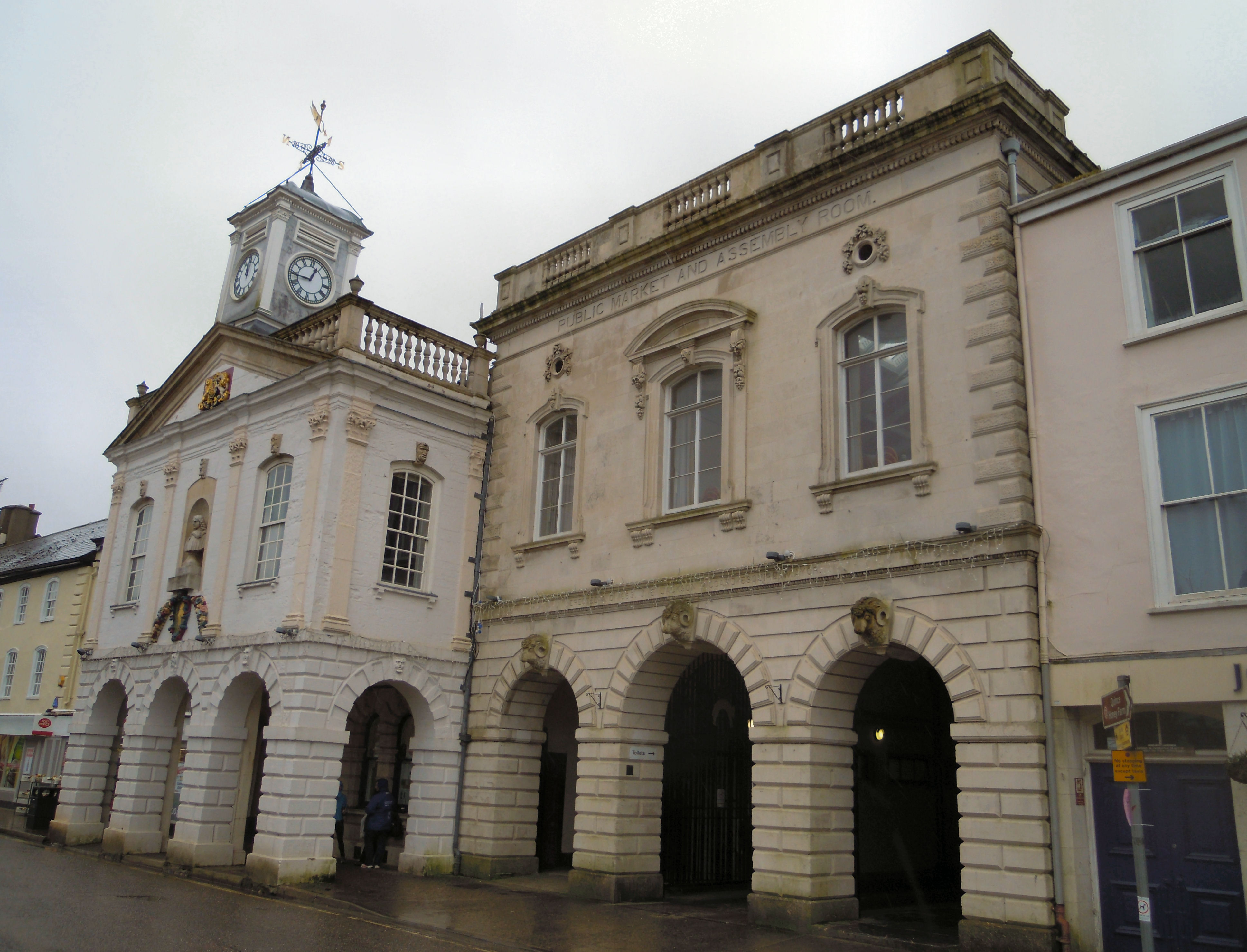
Guildhall, South Molton

The Guildhall on Broad Street in South Molton in Devon was built between 1739 and 1743 and has been a Grade I listed building on the Register of Historic...

Pannier Market, South Molton

South Molton Pannier Market is the pannier market for the town of South Molton in Devon, England located behind the town's Grade I listed Guildhall which...

South Molton Rural District

South Molton Rural District was a rural district in the administrative county of Devon, England, from 1894 to 1974, covering an area in the north of the...

Nearby Amenities

Located within 500m of 51.025968,-3.81281
Power: pole
Lat/Long: 51.0259332/-3.8183928
Power: pole
Lat/Long: 51.0259197/-3.8179743
Material: wood
Power: pole
Lat/Long: 51.0264899/-3.8163435
Power: pole
Lat/Long: 51.0262537/-3.8151017
Power: pole
Lat/Long: 51.0260007/-3.8137391
Power: pole
Lat/Long: 51.0257797/-3.8124678
Power: pole
Lat/Long: 51.0257324/-3.8105473
Power: pole
Lat/Long: 51.0256667/-3.8086644
Power: pole
Source: bing
Lat/Long: 51.0256296/-3.8069646
The data included in this document is from www.openstreetmap.org. The data is made available under ODbL.

Have you been to Pillavins Moors?

Leave your review of Pillavins Moors below (or comments, questions and feedback).