Sand Parks

Downs, Moorland in Devon West Devon

England

Sand Parks
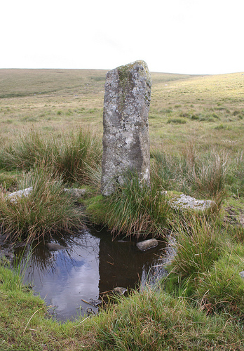
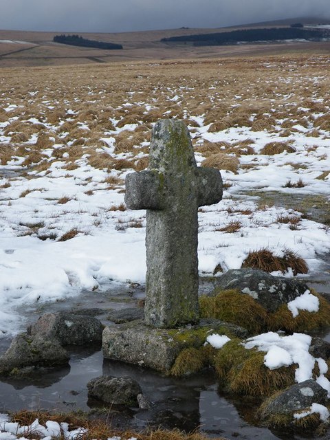
Old Wayside Cross on Dartmoor, near Wheal Anne mine Whealham Bottom Cross (Foxton Cross), standing stone, Starkey No.21 by the footpath, in parish of Dartmoor Forest (West Devon District), Whealham Bottom, near Wheal Anne mine, close to the path from Nuns Cross, in open moorland.

Foxton Cross is a Scheduled Monument, but the grid ref is different from the O.S. map. List Entry Number: 1002559
<span class="nowrap"><a title="https://historicengland.org.uk/listing/the-list/list-entry/1002559" rel="nofollow ugc noopener" href="https://historicengland.org.uk/listing/the-list/list-entry/1002559">Link</a><img style="margin-left:2px;" alt="External link" title="External link - shift click to open in new window" src="https://s1.geograph.org.uk/img/external.png" width="10" height="10"/></span>

Surveyed

Milestone Society National ID: DVWD_DAM10
Old Wayside Cross on Dartmoor, near Wheal Anne mine Credit: Alan Rosevear

The requested URL returned error: 429 Too Many Requests

If you have any feedback on the listing, please let us know in the comments section below.

Sand Parks Images

Images are sourced within 2km of 50.517721/-3.9404071 or Grid Reference SX6270. Thanks to Geograph Open Source API. All images are credited.

Old Wayside Cross on Dartmoor, near Wheal Anne mine Whealham Bottom Cross (Foxton Cross), standing stone, Starkey No.21 by the footpath, in parish of Dartmoor Forest (West Devon District), Whealham Bottom, near Wheal Anne mine, close to the path from Nuns Cross, in open moorland.

Foxton Cross is a Scheduled Monument, but the grid ref is different from the O.S. map. List Entry Number: 1002559
<span class="nowrap"><a title="https://historicengland.org.uk/listing/the-list/list-entry/1002559" rel="nofollow ugc noopener" href="https://historicengland.org.uk/listing/the-list/list-entry/1002559">Link</a><img style="margin-left:2px;" alt="External link" title="External link - shift click to open in new window" src="https://s1.geograph.org.uk/img/external.png" width="10" height="10"/></span>

Surveyed

Milestone Society National ID: DVWD_DAM10
Old Wayside Cross on Dartmoor, near Wheal Anne mine
Whealham Bottom Cross (Foxton Cross), standing stone, Starkey No.21 by the footpath, in parish of Dartmoor Forest (West Devon District), Whealham Bottom, near Wheal Anne mine, close to the path from Nuns Cross, in open moorland. Foxton Cross is a Scheduled Monument, but the grid ref is different from the O.S. map. List Entry Number: 1002559 LinkExternal link Surveyed Milestone Society National ID: DVWD_DAM10
Stone Footbridge over Devonport Leat The leat cuts through the shafts and spoil heaps of Whiteworks Tin Mine.
Stone Footbridge over Devonport Leat
The leat cuts through the shafts and spoil heaps of Whiteworks Tin Mine.
Old Tin Workings Spotted below the road that leads to Whiteworks.
Old Tin Workings
Spotted below the road that leads to Whiteworks.
Enclosed Land at Whiteworks
Site of former tramway to the shafts & buddles One of the key components to the later 19thC tin workings.
Site of former tramway to the shafts & buddles
One of the key components to the later 19thC tin workings.
Old Wayside Cross near Foxtor Mires, Dartmoor Forest Parish Goldsmith's Cross (Foxtor Mires Cross), old head & shaft in a new cross, Starkey No.20 by the footpath, in parish of Dartmoor Forest (West Devon District), on a small ridge, just North of the boundary wall marking the edge of Foxtor Mires, in open moorland.
For another view and more information see <span class="nowrap"><a title="https://www.flickr.com/photos/tollhouses/4945680230" rel="nofollow ugc noopener" href="https://www.flickr.com/photos/tollhouses/4945680230">Link</a><img style="margin-left:2px;" alt="External link" title="External link - shift click to open in new window" src="https://s1.geograph.org.uk/img/external.png" width="10" height="10"/></span>.

Surveyed

Milestone Society National ID: DVWD_DAM07.
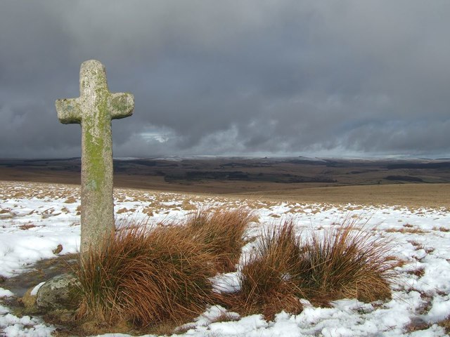
Old Wayside Cross near Foxtor Mires, Dartmoor Forest Parish
Goldsmith's Cross (Foxtor Mires Cross), old head & shaft in a new cross, Starkey No.20 by the footpath, in parish of Dartmoor Forest (West Devon District), on a small ridge, just North of the boundary wall marking the edge of Foxtor Mires, in open moorland. For another view and more information see LinkExternal link. Surveyed Milestone Society National ID: DVWD_DAM07.
Old Wayside Cross north of Fox Tor, Dartmoor Forest Childe's Tomb Cross, old head and shaft in a new cross, Starkey No.19 by the footpath, in parish of Dartmoor Forest (West Devon District), just North of the boundary wall marking the edge of Fox Tor Mires, in open moorland.

Devon & Dartmoor HER listed.
HER Number: MDV6302 <span class="nowrap"><a title="https://www.heritagegateway.org.uk/Gateway/Results_Single.aspx?uid=MDV6302&resourceID=104" rel="nofollow ugc noopener" href="https://www.heritagegateway.org.uk/Gateway/Results_Single.aspx?uid=MDV6302&resourceID=104">Link</a><img style="margin-left:2px;" alt="External link" title="External link - shift click to open in new window" src="https://s1.geograph.org.uk/img/external.png" width="10" height="10"/></span>

Surveyed

Milestone Society National ID: DVWD_DAM06
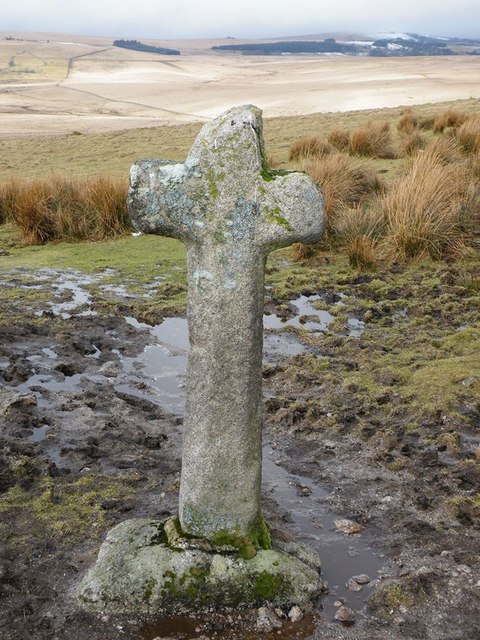
Old Wayside Cross north of Fox Tor, Dartmoor Forest
Childe's Tomb Cross, old head and shaft in a new cross, Starkey No.19 by the footpath, in parish of Dartmoor Forest (West Devon District), just North of the boundary wall marking the edge of Fox Tor Mires, in open moorland. Devon & Dartmoor HER listed. HER Number: MDV6302 LinkExternal link Surveyed Milestone Society National ID: DVWD_DAM06
Joan Ford's Newtake prehistoric stone row A probable prehistoric single stone row measuring 7.27m long, including at least three large-sized upright orthostats and two recumbent slabs situated on a gentle south east facing slope. The stones stand up to between 1.55m and 1.23m high, arranged in height order with the tallest at the east. The row is orientated ENE to NSW and has restricted views of several skyline cairns and surrounding landscape. <span class="nowrap"><a title="https://stonerows.wordpress.com/gazetteer/region/dartmoor/joan-fords-newtake/" rel="nofollow ugc noopener" href="https://stonerows.wordpress.com/gazetteer/region/dartmoor/joan-fords-newtake/">Link</a><img style="margin-left:2px;" alt="External link" title="External link - shift click to open in new window" src="https://s1.geograph.org.uk/img/external.png" width="10" height="10"/></span>
Joan Ford's Newtake prehistoric stone row
A probable prehistoric single stone row measuring 7.27m long, including at least three large-sized upright orthostats and two recumbent slabs situated on a gentle south east facing slope. The stones stand up to between 1.55m and 1.23m high, arranged in height order with the tallest at the east. The row is orientated ENE to NSW and has restricted views of several skyline cairns and surrounding landscape. LinkExternal link
Joan Ford Newtake, East prehistoric cairn and cist A cist complete with displaced capstone. <span class="nowrap"><a title="https://www.megalithic.co.uk/article.php?sid=3295" rel="nofollow ugc noopener" href="https://www.megalithic.co.uk/article.php?sid=3295">Link</a><img style="margin-left:2px;" alt="External link" title="External link - shift click to open in new window" src="https://s1.geograph.org.uk/img/external.png" width="10" height="10"/></span>
Joan Ford Newtake, East prehistoric cairn and cist
A cist complete with displaced capstone. LinkExternal link
Old Wayside Cross Ter Hill (NE) Cross, a wayside cross with an old head & shaft. Set beside a moorland path on Ter Hill, east of Childes tomb in Dartmoor Forest parish. Starkey No.16. A Scheduled Monument <span class="nowrap"><a title="https://historicengland.org.uk/listing/the-list/list-entry/1002618" rel="nofollow ugc noopener" href="https://historicengland.org.uk/listing/the-list/list-entry/1002618">Link</a><img style="margin-left:2px;" alt="External link" title="External link - shift click to open in new window" src="https://s1.geograph.org.uk/img/external.png" width="10" height="10"/></span>. See also <span class="nowrap"><a title="http://www.flickr.com/photos/bridgemarkertim/5306283345" rel="nofollow ugc noopener" href="http://www.flickr.com/photos/bridgemarkertim/5306283345">Link</a><img style="margin-left:2px;" alt="External link" title="External link - shift click to open in new window" src="https://s1.geograph.org.uk/img/external.png" width="10" height="10"/></span> and <a title="https://www.geograph.org.uk/photo/1500839" href="https://www.geograph.org.uk/photo/1500839">Link</a>.

Milestone Society National ID: DVWD_DAM04
Old Wayside Cross
Ter Hill (NE) Cross, a wayside cross with an old head & shaft. Set beside a moorland path on Ter Hill, east of Childes tomb in Dartmoor Forest parish. Starkey No.16. A Scheduled Monument LinkExternal link. See also LinkExternal link and Link. Milestone Society National ID: DVWD_DAM04
Old Wayside Cross Ter Hill (SW) Cross, a wayside cross which replaces an older cross. Set on moorland on the northwest slopes of Ter Hill, southwest of DVWD_DAM04 in Dartmoor Forest parish. Ter Hill Cross (SW) cross was moved to Princetown (see DVWD_DAM08 <a title="https://www.geograph.org.uk/photo/6096353" href="https://www.geograph.org.uk/photo/6096353">Link</a> ) and a replica put on Ter Hill. Starkey No.17. See also <a title="https://www.geograph.org.uk/photo/1500849" href="https://www.geograph.org.uk/photo/1500849">Link</a> and <a title="https://www.geograph.org.uk/photo/644564" href="https://www.geograph.org.uk/photo/644564">Link</a>.

Milestone Society National ID: DVWD_DAM23
Old Wayside Cross
Ter Hill (SW) Cross, a wayside cross which replaces an older cross. Set on moorland on the northwest slopes of Ter Hill, southwest of DVWD_DAM04 in Dartmoor Forest parish. Ter Hill Cross (SW) cross was moved to Princetown (see DVWD_DAM08 Link ) and a replica put on Ter Hill. Starkey No.17. See also Link and Link. Milestone Society National ID: DVWD_DAM23
Old Wayside Cross - Mount Misery Cross Mount Misery Cross, old head & shaft, Starkey No.18 by the moorland path, in parish of Dartmoor Forest (West Devon District), Mount Misery (Fox Tor Newtake), E corner of a wall.

To be surveyed

Milestone Society National ID: DVWD_DAM11
Old Wayside Cross - Mount Misery Cross
Mount Misery Cross, old head & shaft, Starkey No.18 by the moorland path, in parish of Dartmoor Forest (West Devon District), Mount Misery (Fox Tor Newtake), E corner of a wall. To be surveyed Milestone Society National ID: DVWD_DAM11
Hand Hill Cross This cross is 10.6cm tall and is known as "the smallest cross on Dartmoor".
I understand, however, that the Traveller's Ford Cross is slightly smaller. That cross is in <a href="https://www.geograph.org.uk/gridref/SX5978">SX5978</a> but a more precise position is not given, though Explorer OL28 suggests a likely spot. (I say that it 'is' in square SX5978, but it has been removed at least twice and may no longer be there. Perhaps Hand Hill Cross is currently the smallest.)
I find it strange that people should want to place ever-smaller crosses on the moor. But I find it even more strange that other people should want to damage or steal them.
Hand Hill Cross
This cross is 10.6cm tall and is known as "the smallest cross on Dartmoor". I understand, however, that the Traveller's Ford Cross is slightly smaller. That cross is in SX5978 but a more precise position is not given, though Explorer OL28 suggests a likely spot. (I say that it 'is' in square SX5978, but it has been removed at least twice and may no longer be there. Perhaps Hand Hill Cross is currently the smallest.) I find it strange that people should want to place ever-smaller crosses on the moor. But I find it even more strange that other people should want to damage or steal them.
Inscribed cross
Inscribed cross
Sluice Gates on Devonport Leat Should it be required the leat water can be diverted out onto the moor. I should image these were built in order to allow dry access to the tunnel which is a little further downstream.
Sluice Gates on Devonport Leat
Should it be required the leat water can be diverted out onto the moor. I should image these were built in order to allow dry access to the tunnel which is a little further downstream.
Devonport Leat goes underground The Devonport Leat, a long channel feeding Dartmoor water towards the Plymouth suburb of Devonport, uses a tunnel here to pass through higher ground near Nun's Cross Farm.  The tunnel is about 400 metres long and this is the eastern end.  For the other end see <a href="https://www.geograph.org.uk/photo/3426879">SX6069 : Devonport Leat goes underground</a>.  There are notices on the entrances prohibiting entry and warning of the potential of high concentrations of radon, caused by the confined space.
Devonport Leat goes underground
The Devonport Leat, a long channel feeding Dartmoor water towards the Plymouth suburb of Devonport, uses a tunnel here to pass through higher ground near Nun's Cross Farm. The tunnel is about 400 metres long and this is the eastern end. For the other end see SX6069 : Devonport Leat goes underground. There are notices on the entrances prohibiting entry and warning of the potential of high concentrations of radon, caused by the confined space.
Old Boundary Wall This boundary wall is now no more than a grassy hump on the hillside.
Old Boundary Wall
This boundary wall is now no more than a grassy hump on the hillside.
Blacklane Valley The Blacklane Brook runs down this shallow valley between Crane Hill and Naker's Hill.
Blacklane Valley
The Blacklane Brook runs down this shallow valley between Crane Hill and Naker's Hill.
Show me another place!

Sand Parks is located at Grid Ref: SX6270 (Lat: 50.517721, Lng: -3.9404071)

Administrative County: Devon

District: West Devon

Police Authority: Devon and Cornwall

What 3 Words

///digests.shampoos.moped. Near Princetown, Devon

Nearby Locations

Sand Parks

Related Wikis

Childe's Tomb

Childe's Tomb is a granite cross on Dartmoor, Devon, England. Although not in its original form, it is more elaborate than most of the crosses on Dartmoor...

Fox Tor

Fox Tor is a relatively minor tor on Dartmoor in the county of Devon, England.On the flank of the tor, about 500 m to the north stands Childe's Tomb -...

Whiteworks

Whiteworks (or White Works) is a former mining hamlet near the town of Princetown, within Dartmoor National Park, in the English county of Devon. Tin mining...

Duck's Pool, Dartmoor

Duck's Pool is a small depression set in a remote location in the southern half of Dartmoor, Devon, England at grid reference SX624678. It lies between...

Nearby Amenities

Located within 500m of 50.517721,-3.9404071
Childe's Tomb
Historic: monument
Source: survey
Wikidata: Q5097949
Wikipedia: en:Childe's Tomb
Lat/Long: 50.516231/-3.9397973
The data included in this document is from www.openstreetmap.org. The data is made available under ODbL.

Have you been to Sand Parks?

Leave your review of Sand Parks below (or comments, questions and feedback).