Woodcroft Moor

Downs, Moorland in Devon West Devon

England

Woodcroft Moor

Broadwoodkelly: south to Dartmoor Farmland and woodland seen from the Monkokehampton-Winkleigh road, near Mount Pleasant. In the distance the Dartmoor range. The rounded height on the left is Cosdon Hill, spot height 550m
Broadwoodkelly: south to Dartmoor Credit: Martin Bodman

Woodcroft Moor is a charming area located in Devon, England. Situated on the outskirts of the picturesque town of Woodcroft, it is renowned for its stunning natural beauty and diverse landscapes. Covering a vast expanse, the moor incorporates both downs and moorland, offering visitors a unique experience.

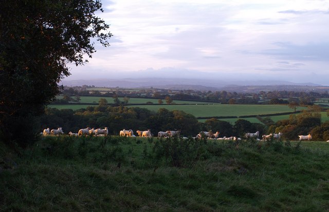
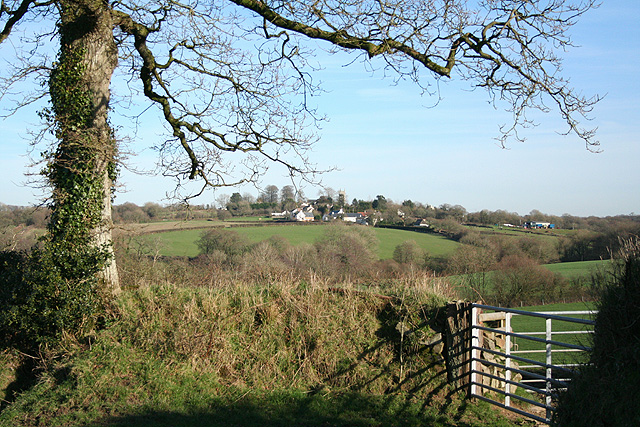
The downs of Woodcroft Moor are characterized by gently rolling hills adorned with lush greenery and scattered with vibrant wildflowers. These open spaces provide breathtaking panoramic views of the surrounding countryside, making it a popular destination for hikers, nature enthusiasts, and photographers alike.

In contrast, the moorland section of Woodcroft Moor is a wild and untamed landscape. Here, visitors can explore vast stretches of heather-covered hills, interspersed with rocky outcrops and peat bogs. The moorland is home to a variety of wildlife, including rare bird species and small mammals, making it a haven for birdwatchers and animal lovers.

Woodcroft Moor offers a range of outdoor activities for visitors to enjoy. From leisurely walks and picnics on the downs to more adventurous pursuits such as mountain biking and horseback riding through the moorland, there is something for everyone. The area also boasts several well-maintained trails and footpaths, allowing visitors to navigate the terrain with ease.

In addition to its natural beauty, Woodcroft Moor is steeped in history and folklore. Ancient burial sites and archaeological remains can be found scattered across the landscape, providing a glimpse into the area's rich past. Local legends and tales of mythical creatures add an element of mystery and intrigue to the moor, captivating the imaginations of those who visit.

Overall, Woodcroft Moor is a captivating and diverse area, offering visitors a unique blend of natural beauty, outdoor activities, and historical significance.

If you have any feedback on the listing, please let us know in the comments section below.

Woodcroft Moor Images

Images are sourced within 2km of 50.82888/-3.9751525 or Grid Reference SS6005. Thanks to Geograph Open Source API. All images are credited.

Broadwoodkelly: south to Dartmoor Farmland and woodland seen from the Monkokehampton-Winkleigh road, near Mount Pleasant. In the distance the Dartmoor range. The rounded height on the left is Cosdon Hill, spot height 550m
Broadwoodkelly: south to Dartmoor
Farmland and woodland seen from the Monkokehampton-Winkleigh road, near Mount Pleasant. In the distance the Dartmoor range. The rounded height on the left is Cosdon Hill, spot height 550m
Field full of sheep Sheep bask uncertainly in a brief spell of early morning sunlight. On the left on the far side of the field is Froggey Plantation. Beyond, the land slopes away to the valleys of the Hole Brook, and, nearer, one of its tributaries. A very long way beyond is Dartmoor, in a coating of cloud. Seen from the lane between Splatt and Monkokehampton.
Field full of sheep
Sheep bask uncertainly in a brief spell of early morning sunlight. On the left on the far side of the field is Froggey Plantation. Beyond, the land slopes away to the valleys of the Hole Brook, and, nearer, one of its tributaries. A very long way beyond is Dartmoor, in a coating of cloud. Seen from the lane between Splatt and Monkokehampton.
Pony's Moor Plantation Seen across a field from the farm track to Stafford Beer.
Pony's Moor Plantation
Seen across a field from the farm track to Stafford Beer.
Exbourne: Coxwell Green Looking west over the Hole Brook valley. Coxwell Green is the house on the right
Exbourne: Coxwell Green
Looking west over the Hole Brook valley. Coxwell Green is the house on the right
Exbourne: Coxwell Green Looking south west
Exbourne: Coxwell Green
Looking south west
Exbourne: copse Looking west
Exbourne: copse
Looking west
Broadwoodkelly: public footpath The path leads to Woodcroft Moor and Broadwoodkelly. Looking north-north-east
Broadwoodkelly: public footpath
The path leads to Woodcroft Moor and Broadwoodkelly. Looking north-north-east
Broadwoodkelly: by Alchey Down The entrance to Alchey Down Farm is on the right. Looking east-south-east towards Corstone
Broadwoodkelly: by Alchey Down
The entrance to Alchey Down Farm is on the right. Looking east-south-east towards Corstone
Broadwoodkelly: Southdown Cross The left turn leads to Coxwell and Exbourne. Looking west-north-west
Broadwoodkelly: Southdown Cross
The left turn leads to Coxwell and Exbourne. Looking west-north-west
Broadwoodkelly: Corstone Farm The left wing appears to be of cob construction. Looking north east
Broadwoodkelly: Corstone Farm
The left wing appears to be of cob construction. Looking north east
Broadwoodkelly: towards Lower Moor Looking south on Taylor’s Down. The sun has bleached out Dartmoor, visible to the naked eye, on the horizon
Broadwoodkelly: towards Lower Moor
Looking south on Taylor’s Down. The sun has bleached out Dartmoor, visible to the naked eye, on the horizon
Broadwoodkelly: east of the village Looking west-south-west towards Dartmoor, just visible on the horizon
Broadwoodkelly: east of the village
Looking west-south-west towards Dartmoor, just visible on the horizon
Broadwoodkelly: by the church Looking east. The lane on the right leads to Shoresgate Cross and Winkleigh
Broadwoodkelly: by the church
Looking east. The lane on the right leads to Shoresgate Cross and Winkleigh
Broadwoodkelly: All Saints’ Church The church, dedicated to All Saints, has a tower with set-back buttresses. The medieval dedication has been lost. Looking north west
Broadwoodkelly: All Saints’ Church
The church, dedicated to All Saints, has a tower with set-back buttresses. The medieval dedication has been lost. Looking north west
Broadwoodkelly: towards the village Looking east near Brixton Barton
Broadwoodkelly: towards the village
Looking east near Brixton Barton
Broadwoodkelly: Methodist church at Splatt Looking north east. Services are held at 11am
Broadwoodkelly: Methodist church at Splatt
Looking north east. Services are held at 11am
Broadwoodkelly: Middlecott Like Brixton Barton and Ingleigh, Middlecott was a Domesday estate. Looking south east
Broadwoodkelly: Middlecott
Like Brixton Barton and Ingleigh, Middlecott was a Domesday estate. Looking south east
Broadwoodkelly: flock of starlings in a tree Near Middlecott. Looking south-south-east
Broadwoodkelly: flock of starlings in a tree
Near Middlecott. Looking south-south-east
Show me another place!

Woodcroft Moor is located at Grid Ref: SS6005 (Lat: 50.82888, Lng: -3.9751525)

Administrative County: Devon

District: West Devon

Police Authority: Devon and Cornwall

What 3 Words

///insolvent.twee.regrowth. Near Winkleigh, Devon

Nearby Locations

Woodcroft Moor Splatt

Related Wikis

Broadwoodkelly

Broadwoodkelly is a village and civil parish in the West Devon district of Devon, England. According to the 2001 census it had a population of 218. The...

Monkokehampton

Monkokehampton is a village and civil parish in West Devon, England. The village lies on the River Okement, about 3 miles (4.8 km) east-north-east of Hatherleigh...

Winkleigh

Winkleigh is a civil parish and small village in Devon, England. It is part of the local government area of Torridge District Council. The population of...

Honeychurch, Devon

Honeychurch is a village and former civil parish now in the parish of Sampford Courtenay, in the West Devon district of the English county of Devon. It...

Exbourne

Exbourne is a village and civil parish in the English county of Devon. The Anglo-Saxon origin of the name is gæces burn - Cuckoo Stream. It occupies a...

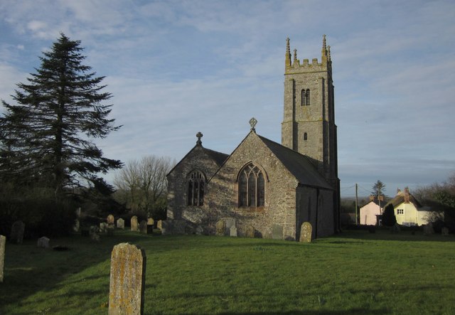
Church of All Saints, Winkleigh

The Church of All Saints is a Church of England parish church in Winkleigh, Devon. The church is a Grade I listed building. == History == The earliest...

Bondleigh

Bondleigh is a village and civil parish in the West Devon district of Devon, England, on the River Taw, north of North Tawton. According to the 2011 census...

Jacobstowe

Jacobstowe is a village and civil parish on the west bank of the River Okement, about 4 miles (6.4 km) north of Okehampton in the West Devon district of...

Nearby Amenities

Located within 500m of 50.82888,-3.9751525
South Down Cross
Is In: Devon
Place: locality
Lat/Long: 50.8266051/-3.9790797
Generator Method: photovoltaic
Generator Output Electricity: yes
Generator Source: solar
Generator Type: solar_photovoltaic_panel
Location: roof
Power: generator
Lat/Long: 50.8249308/-3.9782501
The data included in this document is from www.openstreetmap.org. The data is made available under ODbL.

Have you been to Woodcroft Moor?

Leave your review of Woodcroft Moor below (or comments, questions and feedback).