Doire nam Freumh

Downs, Moorland in Cromartyshire

Scotland

Doire nam Freumh

Carron rapids
Carron rapids Credit: Peter Moore

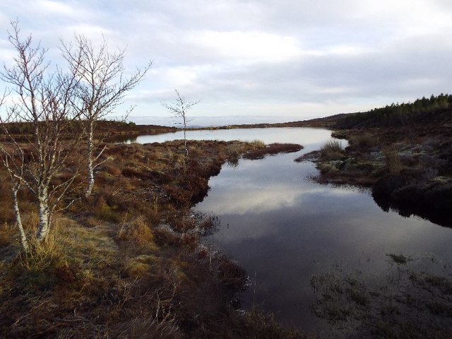
Doire nam Freumh, located in Cromartyshire, is a picturesque area known for its stunning downs and moorland landscape. Situated in the heart of Scotland, this region offers visitors a unique and breathtaking experience of the country's natural beauty.

The downs of Doire nam Freumh are characterized by their gentle rolling hills, covered in lush green grasses and dotted with vibrant wildflowers. The landscape is perfect for leisurely walks and picnics, providing visitors with a tranquil and idyllic setting to unwind and connect with nature.

The moorland of Doire nam Freumh offers a contrasting scenery, with vast expanses of heather-covered terrain stretching as far as the eye can see. This rugged and untamed landscape is home to a variety of wildlife, including native birds, deer, and the elusive Scottish wildcat. Walking through the moors, visitors can immerse themselves in the tranquility of the surroundings, taking in the fresh air and admiring the panoramic views.

Doire nam Freumh is also renowned for its rich history and cultural heritage. The area is scattered with ancient ruins, standing stones, and burial mounds, providing a glimpse into the region's past. Visitors can explore these historical sites, delving into the stories and legends that have shaped the area over the centuries.

In conclusion, Doire nam Freumh in Cromartyshire offers a diverse and captivating landscape, combining the gentle downs with the rugged moorland. Whether visitors seek a peaceful retreat in nature, an opportunity to spot wildlife, or a chance to explore Scotland's history, this area provides an enriching experience for all.

If you have any feedback on the listing, please let us know in the comments section below.

Doire nam Freumh Images

Images are sourced within 2km of 57.887107/-4.5405337 or Grid Reference NH4991. Thanks to Geograph Open Source API. All images are credited.

Carron rapids
Carron rapids
River Carron Near Sgodachail.
River Carron
Near Sgodachail.
River Carron near Sgodachail
Trees at Craig - Upper Strath Carron
Farm building in Upper Strath Carron
Tree beside the road in Upper Strath Carron
Looking Towards Sgodachail Looking towards Sgodachail from the Road.
Looking Towards Sgodachail
Looking towards Sgodachail from the Road.
Disturbed water on River Carron The River Carron in Strathcarron east of Sgodachail looking downstream where its water, already agitated by rocks in its flow is disturbed further by a very strong westerly wind.
Disturbed water on River Carron
The River Carron in Strathcarron east of Sgodachail looking downstream where its water, already agitated by rocks in its flow is disturbed further by a very strong westerly wind.
Mountain slope with birch trees The slope rises on the north side of Strathcarron away from the minor road there.
Mountain slope with birch trees
The slope rises on the north side of Strathcarron away from the minor road there.
Cascade on River Carron The cascade on the River Carron just below the bridge where the roads on the north and south sides of Strathcarron meet.
Cascade on River Carron
The cascade on the River Carron just below the bridge where the roads on the north and south sides of Strathcarron meet.
Minor road with building at The Craigs The Craigs is a location in Strathcarron. The road here is passing the cottage which is set back from it; the building is presumably a farm out-building.
Minor road with building at The Craigs
The Craigs is a location in Strathcarron. The road here is passing the cottage which is set back from it; the building is presumably a farm out-building.
Field near Amatnatua The exact location of Amatnatua isn't positively ascertained from OS maps - but it's in this vicinity! The name of the river beyond the field is equally unclear though it's obviously at this point the main flow of what becomes the River Carron. The trees along the field boundary appear to have been originally a hedge; one that has now run wild.
Field near Amatnatua
The exact location of Amatnatua isn't positively ascertained from OS maps - but it's in this vicinity! The name of the river beyond the field is equally unclear though it's obviously at this point the main flow of what becomes the River Carron. The trees along the field boundary appear to have been originally a hedge; one that has now run wild.
Bridge at East Amat The River Carron has the advantage of being runnable (for kayakers) in low water when other rivers just are too much of a bump and scrape. It was barely worth driving all the way from Fort William, but such were the drought conditions at Easter 2013 that we had been doing a lot of travelling looking for water all week !

The worthwhile section starts at a put-in river left, from a layby just above the bridge seen here and bumps down one cascade before passing under the road. The view is from part way down the next set of technical rapids where the map marks "waterfall". The waterfall itself is a vertical drop into a boily rockmill that paddlers shy away from (well, at this level, certainly) and known as "Granny's hole". There are much safer ways down, leading to a fine gorge, but it would have been nicer to have at least a bit more water than shown here.
Bridge at East Amat
The River Carron has the advantage of being runnable (for kayakers) in low water when other rivers just are too much of a bump and scrape. It was barely worth driving all the way from Fort William, but such were the drought conditions at Easter 2013 that we had been doing a lot of travelling looking for water all week ! The worthwhile section starts at a put-in river left, from a layby just above the bridge seen here and bumps down one cascade before passing under the road. The view is from part way down the next set of technical rapids where the map marks "waterfall". The waterfall itself is a vertical drop into a boily rockmill that paddlers shy away from (well, at this level, certainly) and known as "Granny's hole". There are much safer ways down, leading to a fine gorge, but it would have been nicer to have at least a bit more water than shown here.
River Carron, rapid 550m below East Amat bridge One of the more challenging bits of the River Carron in low water, the flow is funnelled into a narrow slot which is, in itself, not too difficult. The problem lies just below where the flow comes up against the left bank in a big boil, where the paddler has not yet had enough space to get a paddle stroke in. Sad to say, this one had me, and with a further GoPro camera on a pole stuck up behind my head, I failed to roll up - a definite warning against taking photography more seriously than survival ! It's not a particularly bad place to swim, just annoying, and as it was the second such failure in less than half a mile, I felt I had to remove the third camera before continuing (a ploy that worked, as I didn't swim again that day despite the odd capsize).
River Carron, rapid 550m below East Amat bridge
One of the more challenging bits of the River Carron in low water, the flow is funnelled into a narrow slot which is, in itself, not too difficult. The problem lies just below where the flow comes up against the left bank in a big boil, where the paddler has not yet had enough space to get a paddle stroke in. Sad to say, this one had me, and with a further GoPro camera on a pole stuck up behind my head, I failed to roll up - a definite warning against taking photography more seriously than survival ! It's not a particularly bad place to swim, just annoying, and as it was the second such failure in less than half a mile, I felt I had to remove the third camera before continuing (a ploy that worked, as I didn't swim again that day despite the odd capsize).
Beach above the Carron gorge Following on from rocky rapids below East Amat, the River Carron flattens out for a kilometre before the start of its gorge. This beach, river right, provided a handy landing spot for a quick inspection of the rather more exciting bit of river which continues for the next 400 metres to a footbridge below the Old Schoolhouse. There's a rocky shelf river left which is just as good for a quick nip out to the bank, but trees make getting a view ahead a little awkward that side, so a longer walk is needed.
Beach above the Carron gorge
Following on from rocky rapids below East Amat, the River Carron flattens out for a kilometre before the start of its gorge. This beach, river right, provided a handy landing spot for a quick inspection of the rather more exciting bit of river which continues for the next 400 metres to a footbridge below the Old Schoolhouse. There's a rocky shelf river left which is just as good for a quick nip out to the bank, but trees make getting a view ahead a little awkward that side, so a longer walk is needed.
River Carron near Amat
West end of False Loch a' Bhaid Bheithe above Strathcarron near Ardgay
Cnoc a' Bhaid Bheithe above Strathcarron
Show me another place!

Doire nam Freumh is located at Grid Ref: NH4991 (Lat: 57.887107, Lng: -4.5405337)

Unitary Authority: Highland

Police Authority: Highlands and Islands

What 3 Words

///stews.liquid.switch. Near Lairg, Highland

Nearby Locations

Doire nam Freumh

Related Wikis

Amatnatua

Amatnatua (Scottish Gaelic: Àmait na Tuath) is a hamlet in Highland, Scotland.

Alladale Wilderness Reserve

Alladale Wilderness Reserve is a 23,000-acre (93 km2) highland estate in the Caledonian Forest in Sutherland, in the Scottish Highlands. The estate was...

Battle of Aldy Charrish

The Battle of Aldy Charrish (also known as the Battle of Auldicharish, Aldicharrish, Aldecharwis, Alt a'Charrais, Alt Charrais, Alt na Charrais) was a...

Achnahanat

Achnahanat (Scottish Gaelic: Achadh na h-Annaid) is a crofting settlement on the south side of the Kyle of Sutherland in Scotland. It is about 4 miles...

Dounie

Dounie (Scottish Gaelic: Dùnaidh) is a small remote scattered hamlet in Sutherland, Scottish Highlands and is in the Scottish council area of Highland...

Battle of Carbisdale

The Battle of Carbisdale (also known as Invercarron) took place close to the village of Culrain, Sutherland, Scotland on 27 April 1650 and was part of...

Càrn Chuinneag

Carn Chuinneag (839 m) is a mountain in the Northwest Highlands of Scotland, south of Strathcarron in Sutherland. A distinct twin-summited peak, it lies...

Rhelonie

Rhelonie (Scottish Gaelic: Ruigh an Lòin) is a crofting hamlet in the Highland region of Scotland. Rhelonie is 2 miles northwest of the village of Culrain...

Nearby Amenities

Located within 500m of 57.887107,-4.5405337
Power: pole
Lat/Long: 57.888458/-4.5478976
Power: pole
Lat/Long: 57.8889744/-4.5467452
Power: pole
Lat/Long: 57.8894023/-4.5460229
Power: pole
Lat/Long: 57.890004/-4.5449376
Power: pole
Lat/Long: 57.8904154/-4.5441365
Power: pole
Lat/Long: 57.8908939/-4.543208
Power: pole
Lat/Long: 57.8914242/-4.5421859
The data included in this document is from www.openstreetmap.org. The data is made available under ODbL.

Have you been to Doire nam Freumh?

Leave your review of Doire nam Freumh below (or comments, questions and feedback).