Amat Forest

Downs, Moorland in Ross-shire

Scotland

Amat Forest

Forest Farm near Croick
Forest Farm near Croick Credit: Peter Moore

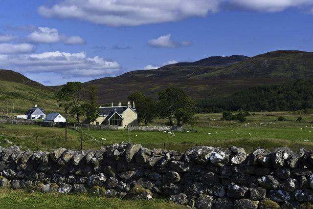
Amat Forest, located in Ross-shire, Scotland, is a picturesque natural landscape that encompasses downs and moorland. Covering an area of approximately [insert size], this site offers a diverse array of flora and fauna, making it a treasured destination for nature enthusiasts.

The downs of Amat Forest are characterized by gently rolling hills that provide breathtaking views of the surrounding countryside. Blanketed with lush grasses and scattered with wildflowers, these downs serve as a haven for grazing animals such as sheep and deer. Visitors can explore the network of trails that wind through the downs, offering opportunities for leisurely walks and stunning vistas.

In contrast, the moorland of Amat Forest showcases a more rugged and untamed environment. Here, the landscape is dominated by heather-covered hills, interspersed with peat bogs and small lochs. The moorland provides a habitat for a variety of bird species, including the iconic red grouse, as well as other wildlife such as hares and foxes. Adventurous hikers can traverse the challenging terrain, immersing themselves in the wild beauty of the moorland.

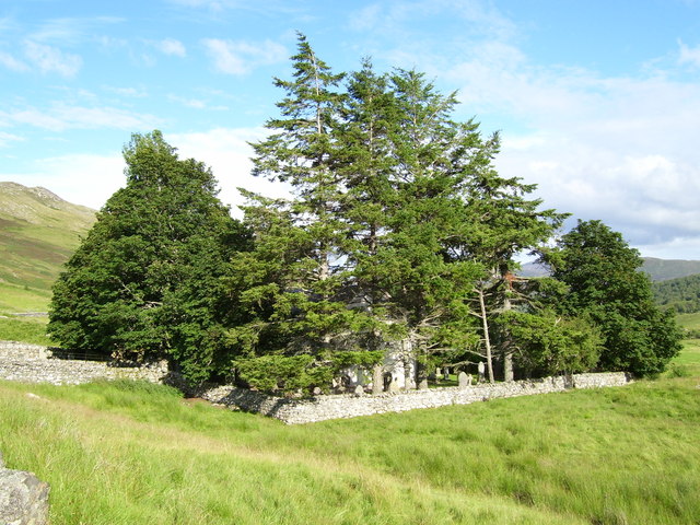
Amat Forest is not only a haven for nature lovers but also offers historical and cultural significance. The area is scattered with remnants of ancient settlements and burial sites, providing glimpses into the region's rich past.

Overall, Amat Forest in Ross-shire is a captivating landscape, offering a blend of downs and moorland that showcases the beauty and diversity of the Scottish countryside.

If you have any feedback on the listing, please let us know in the comments section below.

Amat Forest Images

Images are sourced within 2km of 57.874523/-4.6006158 or Grid Reference NH4590. Thanks to Geograph Open Source API. All images are credited.

Forest Farm near Croick
Mission hall and Phonebox Forget trying to make a call though, the telephone is long gone and it is used as a notice board
Mission hall and Phonebox
Forget trying to make a call though, the telephone is long gone and it is used as a notice board
Trees at Craig - Upper Strath Carron
Gravestones on north side of Croick church The church at Croick in Strathcarron is famed as the place where families evicted from the glen during The Clearances sheltered before their removal and where some scratched their names on to the glass of the windows.
Gravestones on north side of Croick church
The church at Croick in Strathcarron is famed as the place where families evicted from the glen during The Clearances sheltered before their removal and where some scratched their names on to the glass of the windows.
Corrugated metal shed in Strathcarron The building stands on the south side of the valley road between Croick and The Craigs. The river here is known as the Black Water.
Corrugated metal shed in Strathcarron
The building stands on the south side of the valley road between Croick and The Craigs. The river here is known as the Black Water.
Flat ground beside River Carron This land beside the River Carron between The Craigs and Croick can at best be described as rough grazing but in reality it's little more than moorland
Flat ground beside River Carron
This land beside the River Carron between The Craigs and Croick can at best be described as rough grazing but in reality it's little more than moorland
Road between Croick and The Craigs The road is in Strathcarron and is seen heading eastwards towards The Craigs.
Road between Croick and The Craigs
The road is in Strathcarron and is seen heading eastwards towards The Craigs.
Minor road with building at The Craigs The Craigs is a location in Strathcarron. The road here is passing the cottage which is set back from it; the building is presumably a farm out-building.
Minor road with building at The Craigs
The Craigs is a location in Strathcarron. The road here is passing the cottage which is set back from it; the building is presumably a farm out-building.
Croick Church
Croick Church
Croick Church
Croick Church
Footbridge over the River Carron
Looking east along the road near Forrest Farm
Croick Church
Croick Church
Written in desperation: etched words on Croick Church "Glencalvie people - the wicked generation"

The sad story of the eviction from Glen Calvie and Croick and the parishioners huddled in the lee of the church as they waited their fate is explained on an information board.  The church is part of the parish of Edderton, Croick and Ardgay and four services a year are held here in the summer. The church seemed to be in an excellent state of repair.

See <a href="https://www.geograph.org.uk/photo/19108">NH4591 : Glencalvie: "The wicked generation"</a> for an extended description and Richard Webb's image of the same window.
Written in desperation: etched words on Croick Church
"Glencalvie people - the wicked generation" The sad story of the eviction from Glen Calvie and Croick and the parishioners huddled in the lee of the church as they waited their fate is explained on an information board. The church is part of the parish of Edderton, Croick and Ardgay and four services a year are held here in the summer. The church seemed to be in an excellent state of repair. See NH4591 : Glencalvie: "The wicked generation" for an extended description and Richard Webb's image of the same window.
Amat Forest, Ross-shire
Strath Cuileannach near Croick, Ross-shire View looking west up the Cuileannach valley near to Croick in Ross-shire, Scottish Highlands.
Strath Cuileannach near Croick, Ross-shire
View looking west up the Cuileannach valley near to Croick in Ross-shire, Scottish Highlands.
Amatnatua in Strathcarron End of the road at Amatnatua in Strathcarron.
Amatnatua in Strathcarron
End of the road at Amatnatua in Strathcarron.
Croick in Strathcarron Looking towards Croick House and Croick Church in the distance.
Croick in Strathcarron
Looking towards Croick House and Croick Church in the distance.
Show me another place!

Amat Forest is located at Grid Ref: NH4590 (Lat: 57.874523, Lng: -4.6006158)

Unitary Authority: Highland

Police Authority: Highlands and Islands

What 3 Words

///coconut.picture.enough. Near Lairg, Highland

Related Wikis

Amatnatua

Amatnatua (Scottish Gaelic: Àmait na Tuath) is a hamlet in Highland, Scotland.

Alladale Wilderness Reserve

Alladale Wilderness Reserve is a 23,000-acre (93 km2) highland estate in the Caledonian Forest in Sutherland, in the Scottish Highlands. The estate was...

Càrn Chuinneag

Carn Chuinneag (839 m) is a mountain in the Northwest Highlands of Scotland, south of Strathcarron in Sutherland. A distinct twin-summited peak, it lies...

Battle of Aldy Charrish

The Battle of Aldy Charrish (also known as the Battle of Auldicharish, Aldicharrish, Aldecharwis, Alt a'Charrais, Alt Charrais, Alt na Charrais) was a...

Nearby Amenities

Located within 500m of 57.874523,-4.6006158
Power: pole
Lat/Long: 57.8736948/-4.6080886
Power: pole
Lat/Long: 57.8737652/-4.6067804
Power: pole
Lat/Long: 57.8738408/-4.6053827
Power: pole
Lat/Long: 57.8739153/-4.603981
Power: pole
Lat/Long: 57.8739609/-4.6032179
Power: pole
Lat/Long: 57.8740189/-4.6021005
Power: pole
Lat/Long: 57.8740893/-4.6009402
Power: pole
Lat/Long: 57.8741348/-4.5997897
Power: pole
Lat/Long: 57.8741969/-4.5986139
Power: pole
Lat/Long: 57.8749071/-4.5980123
Power: pole
Lat/Long: 57.8761079/-4.5978585
Power: pole
Lat/Long: 57.8766628/-4.5978079
Power: pole
Lat/Long: 57.8774029/-4.5979053
Power: pole
Lat/Long: 57.878085/-4.5980376
Power: pole
Lat/Long: 57.8783697/-4.5977885
The data included in this document is from www.openstreetmap.org. The data is made available under ODbL.

Have you been to Amat Forest?

Leave your review of Amat Forest below (or comments, questions and feedback).