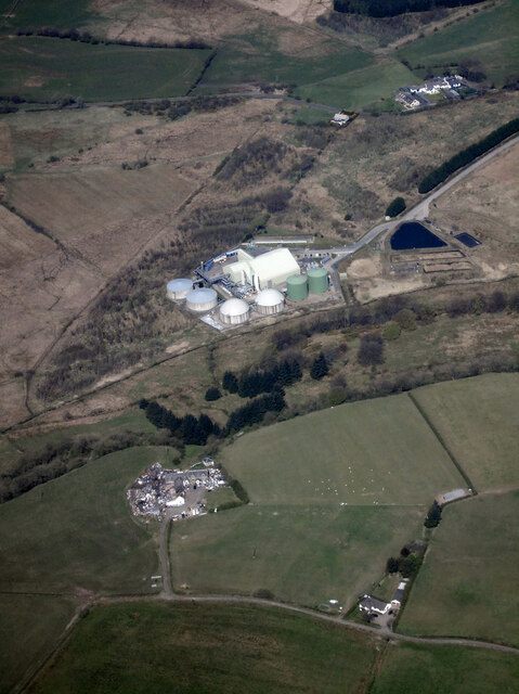
Bankhead Moss

Downs, Moorland in Ayrshire

Scotland

Bankhead Moss

West Middlebank from the air With Barkip biogas power station in the background.
West Middlebank from the air Credit: Thomas Nugent

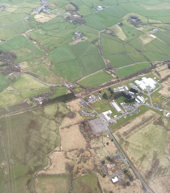
Bankhead Moss is a vast expanse of downs and moorland located in Ayrshire, Scotland. Spanning approximately 500 acres, it is a prominent feature of the local landscape. The moss is situated in the southern part of the region, near the village of Bankhead.

The terrain of Bankhead Moss consists mainly of gently rolling hills covered in heather, grasses, and moss. The area is characterized by its wet and boggy conditions, with numerous small streams and pools interspersed throughout. These wetlands provide a habitat for a diverse range of flora and fauna, including various species of birds, insects, and plant life.

The moss is a designated Site of Special Scientific Interest (SSSI) due to its ecological importance. It serves as a vital breeding and feeding ground for several rare bird species, such as the curlew and lapwing. Additionally, the moss supports a variety of plant species, including sphagnum moss and cotton grass, which thrive in the moist conditions.

Bankhead Moss is a popular destination for nature enthusiasts and birdwatchers. Its tranquil and unspoiled surroundings offer a peaceful retreat for those seeking a break from urban life. The moss also provides opportunities for outdoor activities such as walking, hiking, and photography.

In summary, Bankhead Moss is a significant downs and moorland area in Ayrshire, Scotland. Its wet and boggy conditions, diverse flora and fauna, and status as an SSSI make it a valuable natural asset in the region.

If you have any feedback on the listing, please let us know in the comments section below.

Bankhead Moss Images

Images are sourced within 2km of 55.72062/-4.6312898 or Grid Reference NS3450. Thanks to Geograph Open Source API. All images are credited.

West Middlebank from the air With Barkip biogas power station in the background.
West Middlebank from the air
With Barkip biogas power station in the background.
West Middlebank from the air With Barkip biogas power station in the background and West Giffen Cottage in the right foreground.
West Middlebank from the air
With Barkip biogas power station in the background and West Giffen Cottage in the right foreground.
Bridge, Waterside A minor road crosses the remains of the Lanarkshire and Ayrshire Railway between Kilwinning and Lugton.
Bridge, Waterside
A minor road crosses the remains of the Lanarkshire and Ayrshire Railway between Kilwinning and Lugton.
Lanarkshire and Ayrshire Railway The remains of the trackbed between Lugton and Kilwinning.
Lanarkshire and Ayrshire Railway
The remains of the trackbed between Lugton and Kilwinning.
Woodland, Bankhead Blue tarpaulins cover firewood.
Woodland, Bankhead
Blue tarpaulins cover firewood.
Middlebank pasture Better looking grass than some fields around DM Beith. There is roll of old fencing wire in the foreground.
Middlebank pasture
Better looking grass than some fields around DM Beith. There is roll of old fencing wire in the foreground.
Wet depression A waterlogged hollow at East Middlebank.
Wet depression
A waterlogged hollow at East Middlebank.
DM Beith from the air The north corner of the vast site at the B706 road can be seen in this view.
DM Beith from the air
The north corner of the vast site at the B706 road can be seen in this view.
DM Beith from the air Part of the sprawling complex can be seen in the foreground, where the B706 road at Bellcraig Bridge can also be seen.
DM Beith from the air
Part of the sprawling complex can be seen in the foreground, where the B706 road at Bellcraig Bridge can also be seen.
Barkip Anaerobic Digestion Plant from the air A grand name for the biogas power station which is operated by SSE in the shadow of DM Beith. 

See also <a href="https://www.geograph.org.uk/photo/6042608">NS3350 : Barkip Anaerobic Digestion Plant from the air</a>.

The following text is quoted from the SSE web site <span class="nowrap"><a title="http://sse.com/whatwedo/ourprojectsandassets/renewables/barkip/" rel="nofollow ugc noopener" href="http://sse.com/whatwedo/ourprojectsandassets/renewables/barkip/">Link</a><img style="margin-left:2px;" alt="External link" title="External link - shift click to open in new window" src="https://s1.geograph.org.uk/img/external.png" width="10" height="10"/></span> .  

"SSE Barkip anaerobic digestion plant is the largest combined organic waste treatment and energy generating facility in Scotland. This innovatively designed plant can process up to 75,000 tonnes of organic and food waste annually and produce 2.2MW of renewable electricity 24/7 from the biogas produced. Bacteria break down the waste to produce methane rich biogas, combusted in gas engines to generate electricity. All the heat used in the process is recovered from the engines. The plant produces a low cost PAS110 fertiliser to support local agriculture.

The facility is a zero-waste solution and has a major role to play in meeting Scotland's renewable energy production and waste recycling targets".
Barkip Anaerobic Digestion Plant from the air
A grand name for the biogas power station which is operated by SSE in the shadow of DM Beith. See also NS3350 : Barkip Anaerobic Digestion Plant from the air. The following text is quoted from the SSE web site LinkExternal link . "SSE Barkip anaerobic digestion plant is the largest combined organic waste treatment and energy generating facility in Scotland. This innovatively designed plant can process up to 75,000 tonnes of organic and food waste annually and produce 2.2MW of renewable electricity 24/7 from the biogas produced. Bacteria break down the waste to produce methane rich biogas, combusted in gas engines to generate electricity. All the heat used in the process is recovered from the engines. The plant produces a low cost PAS110 fertiliser to support local agriculture. The facility is a zero-waste solution and has a major role to play in meeting Scotland's renewable energy production and waste recycling targets".
DM Beith from the air The following was taken largely from the wikimappia article about the depot <span class="nowrap"><a title="http://wikimapia.org/1607141/DM-former-RNAD-Beith" rel="nofollow ugc noopener" href="http://wikimapia.org/1607141/DM-former-RNAD-Beith">Link</a><img style="margin-left:2px;" alt="External link" title="External link - shift click to open in new window" src="https://s1.geograph.org.uk/img/external.png" width="10" height="10"/></span> .

Beith was established in 1943, as an MoD Munitions Depot during World War II. The site has facilities to store, maintain, modify, refurbish, produce and test weapons for all the armed services. As a result of the range of services it offers, the site has grown over the years, occupying almost 1,000 acres of rural land, and employing over 400 non-military staff.

Now known as DM Beith (Defence Munitions), the name of the site has changed over the years, most recently known as DSDA Beith (Defence Storage and Distribution Agency), and before that as RNAD Beith (Royal Naval Armament Depot). The site is reputed to have some 21 miles of internal roads, and almost seven miles of perimeter fence. The depot's storage capacity is some 18,000 cubic metres, with the buildings designed to implode in the event of an accident; the walls are intended to collapse inwards, while the roofs are intended to blow off, directing the main effects of any blast upwards, rather than sideways towards neighbouring stores. The site also includes not one but two Integrated Weapons Complex (IWC) buildings, which are capable of the most sophisticated sensitive weapons assembly and refit tasks. 

Munitions handled at Beith include the ALARM (air launched anti-radiation missile), Tomahawk, Storm Shadow, and Brimstone missiles, and the Spearfish torpedo.
DM Beith from the air
The following was taken largely from the wikimappia article about the depot LinkExternal link . Beith was established in 1943, as an MoD Munitions Depot during World War II. The site has facilities to store, maintain, modify, refurbish, produce and test weapons for all the armed services. As a result of the range of services it offers, the site has grown over the years, occupying almost 1,000 acres of rural land, and employing over 400 non-military staff. Now known as DM Beith (Defence Munitions), the name of the site has changed over the years, most recently known as DSDA Beith (Defence Storage and Distribution Agency), and before that as RNAD Beith (Royal Naval Armament Depot). The site is reputed to have some 21 miles of internal roads, and almost seven miles of perimeter fence. The depot's storage capacity is some 18,000 cubic metres, with the buildings designed to implode in the event of an accident; the walls are intended to collapse inwards, while the roofs are intended to blow off, directing the main effects of any blast upwards, rather than sideways towards neighbouring stores. The site also includes not one but two Integrated Weapons Complex (IWC) buildings, which are capable of the most sophisticated sensitive weapons assembly and refit tasks. Munitions handled at Beith include the ALARM (air launched anti-radiation missile), Tomahawk, Storm Shadow, and Brimstone missiles, and the Spearfish torpedo.
DM Beith from the air Looking east over Little Barkip.
DM Beith from the air
Looking east over Little Barkip.
DM Beith from the air The following was taken largely from the wikimappia article about the depot <span class="nowrap"><a title="http://wikimapia.org/1607141/DM-former-RNAD-Beith" rel="nofollow ugc noopener" href="http://wikimapia.org/1607141/DM-former-RNAD-Beith">Link</a><img style="margin-left:2px;" alt="External link" title="External link - shift click to open in new window" src="https://s1.geograph.org.uk/img/external.png" width="10" height="10"/></span> .

Beith was established in 1943, as an MoD Munitions Depot during World War II. The site has facilities to store, maintain, modify, refurbish, produce and test weapons for all the armed services. As a result of the range of services it offers, the site has grown over the years, occupying almost 1,000 acres of rural land, and employing over 400 non-military staff.

Now known as DM Beith (Defence Munitions), the name of the site has changed over the years, most recently known as DSDA Beith (Defence Storage and Distribution Agency), and before that as RNAD Beith (Royal Naval Armament Depot). The site is reputed to have some 21 miles of internal roads, and almost seven miles of perimeter fence. The depot's storage capacity is some 18,000 cubic metres, with the buildings designed to implode in the event of an accident; the walls are intended to collapse inwards, while the roofs are intended to blow off, directing the main effects of any blast upwards, rather than sideways towards neighbouring stores. The site also includes not one but two Integrated Weapons Complex (IWC) buildings, which are capable of the most sophisticated sensitive weapons assembly and refit tasks. 

Munitions handled at Beith include the ALARM (air launched anti-radiation missile), Tomahawk, Storm Shadow, and Brimstone missiles, and the Spearfish torpedo.
DM Beith from the air
The following was taken largely from the wikimappia article about the depot LinkExternal link . Beith was established in 1943, as an MoD Munitions Depot during World War II. The site has facilities to store, maintain, modify, refurbish, produce and test weapons for all the armed services. As a result of the range of services it offers, the site has grown over the years, occupying almost 1,000 acres of rural land, and employing over 400 non-military staff. Now known as DM Beith (Defence Munitions), the name of the site has changed over the years, most recently known as DSDA Beith (Defence Storage and Distribution Agency), and before that as RNAD Beith (Royal Naval Armament Depot). The site is reputed to have some 21 miles of internal roads, and almost seven miles of perimeter fence. The depot's storage capacity is some 18,000 cubic metres, with the buildings designed to implode in the event of an accident; the walls are intended to collapse inwards, while the roofs are intended to blow off, directing the main effects of any blast upwards, rather than sideways towards neighbouring stores. The site also includes not one but two Integrated Weapons Complex (IWC) buildings, which are capable of the most sophisticated sensitive weapons assembly and refit tasks. Munitions handled at Beith include the ALARM (air launched anti-radiation missile), Tomahawk, Storm Shadow, and Brimstone missiles, and the Spearfish torpedo.
Barkip Anaerobic Digestion Plant from the air A grand name for the biogas power station which is operated by SSE in the shadow of DM Beith. 

The following text is quoted from the SSE web site <span class="nowrap"><a title="http://sse.com/whatwedo/ourprojectsandassets/renewables/barkip/" rel="nofollow ugc noopener" href="http://sse.com/whatwedo/ourprojectsandassets/renewables/barkip/">Link</a><img style="margin-left:2px;" alt="External link" title="External link - shift click to open in new window" src="https://s1.geograph.org.uk/img/external.png" width="10" height="10"/></span> .  

"SSE Barkip anaerobic digestion plant is the largest combined organic waste treatment and energy generating facility in Scotland. This innovatively designed plant can process up to 75,000 tonnes of organic and food waste annually and produce 2.2MW of renewable electricity 24/7 from the biogas produced. Bacteria break down the waste to produce methane rich biogas, combusted in gas engines to generate electricity. All the heat used in the process is recovered from the engines. The plant produces a low cost PAS110 fertiliser to support local agriculture.

The facility is a zero-waste solution and has a major role to play in meeting Scotland's renewable energy production and waste recycling targets".
Barkip Anaerobic Digestion Plant from the air
A grand name for the biogas power station which is operated by SSE in the shadow of DM Beith. The following text is quoted from the SSE web site LinkExternal link . "SSE Barkip anaerobic digestion plant is the largest combined organic waste treatment and energy generating facility in Scotland. This innovatively designed plant can process up to 75,000 tonnes of organic and food waste annually and produce 2.2MW of renewable electricity 24/7 from the biogas produced. Bacteria break down the waste to produce methane rich biogas, combusted in gas engines to generate electricity. All the heat used in the process is recovered from the engines. The plant produces a low cost PAS110 fertiliser to support local agriculture. The facility is a zero-waste solution and has a major role to play in meeting Scotland's renewable energy production and waste recycling targets".
Beith and DM Beith from the air Part of DM Beith is in the foreground. Barr Loch, Castle Semple Loch and Lochwinnoch are in the distance.
Beith and DM Beith from the air
Part of DM Beith is in the foreground. Barr Loch, Castle Semple Loch and Lochwinnoch are in the distance.
Bridge Bridge carrying the road over the line of a disused railway.
Bridge
Bridge carrying the road over the line of a disused railway.
A Grey Day The road to Newhouse farm under a grey November sky.
A Grey Day
The road to Newhouse farm under a grey November sky.
Knollhead Farm Farmhouse and buildings to the east of Dalry
Knollhead Farm
Farmhouse and buildings to the east of Dalry
Show me another place!

Bankhead Moss is located at Grid Ref: NS3450 (Lat: 55.72062, Lng: -4.6312898)

Unitary Authority: North Ayrshire

Police Authority: Ayrshire

What 3 Words

///twin.sharpens.trophy. Near Beith, North Ayrshire

Nearby Locations

Bankhead Moss

Related Wikis

Giffen railway station

Giffen railway station was a railway station approximately one mile south-west of the village of Barrmill, North Ayrshire, Scotland. The station was part...

Lands of Bogston

Bogston or later Bogstone was a small estate in the old Barony of Giffen near Barrmill in the Parish of Beith, North Ayrshire, once held by collateral...

Brackenhills railway station

Brackenhills railway station was a railway station approximately one mile south-west of the town of Beith, close to Barkip, North Ayrshire, Scotland, part...

Nettlehirst

Nettlehirst or Nettlehurst was a small mansion house (NS365504) and estate in the Parish of Beith, near Barrmill in North Ayrshire, Scotland. The house...

Barrmill, North Ayrshire

Barrmill is a small village in North Ayrshire, Scotland about 1+1⁄2 miles (2.5 kilometres) east of Beith on the road to Burnhouse and Lugton. Locally it...

Barrmill railway station

Barrmill railway station was a railway station serving the village of Barrmill, North Ayrshire, Scotland. The station was originally part of the Glasgow...

Auchenmade railway station

Auchenmade railway station was a railway station approximately three miles (4.8 km) north-east of Kilwinning on the B707, North Ayrshire, Scotland. It...

Barkip

Barkip, also known as The Den, is a hamlet in North Ayrshire, Scotland about three miles (five kilometres) southwest of Beith on the A737 road to Dalry...

Nearby Amenities

Located within 500m of 55.72062,-4.6312898
Railway: switch
Lat/Long: 55.7228625/-4.6274515
Giffen Coal Pit No1
Historic: mine
Lat/Long: 55.7181911/-4.6347269
Railway: switch
Lat/Long: 55.7240703/-4.6330062
Railway: level_crossing
Lat/Long: 55.7215393/-4.6246799
Railway: level_crossing
Lat/Long: 55.7214914/-4.624779
The data included in this document is from www.openstreetmap.org. The data is made available under ODbL.

Have you been to Bankhead Moss?

Leave your review of Bankhead Moss below (or comments, questions and feedback).