Craigdow Moor

Downs, Moorland in Wigtownshire

Scotland

Craigdow Moor

Craigdow Moor and the Craigdow Burn The Craigdow Burn snakes its way across Craigdow Moor.
Craigdow Moor and the Craigdow Burn Credit: David Baird

Craigdow Moor is a picturesque expanse of downs and moorland situated in Wigtownshire, Scotland. Spanning an area of approximately 4,000 acres, it is renowned for its stunning natural beauty and diverse wildlife.

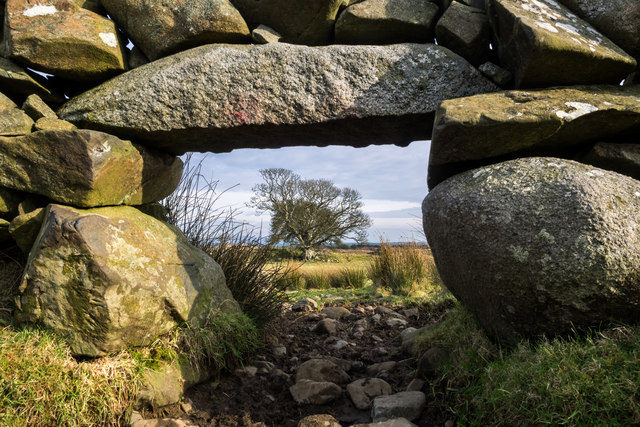
The moorland is characterized by gently rolling hills, covered in vibrant purple heather during the summer months, creating a breathtaking sight. The landscape is dotted with scattered rocky outcrops, providing a dramatic contrast to the lush greenery of the surrounding area. The moorland is crisscrossed by a network of narrow footpaths, allowing visitors to explore the area and soak in the tranquil atmosphere.

Craigdow Moor is home to a rich variety of flora and fauna. The heather-covered slopes provide an ideal habitat for numerous bird species, including skylarks, stonechats, and meadow pipits. Birdwatchers can spot these avian inhabitants soaring through the sky or perched on the rocks. The moor is also inhabited by small mammals such as rabbits and voles, as well as occasional sightings of red deer.

The moorland offers stunning panoramic views of the surrounding countryside, with the distant hills and valleys adding to its allure. The area is a haven for nature lovers and walkers, who can immerse themselves in the peacefulness and serenity of the landscape.

In summary, Craigdow Moor in Wigtownshire is a captivating expanse of downs and moorland, boasting a wealth of natural wonders. Its rolling hills, heather-clad slopes, and abundant wildlife make it an idyllic destination for those seeking solace and a connection with nature.

If you have any feedback on the listing, please let us know in the comments section below.

Craigdow Moor Images

Images are sourced within 2km of 54.879488/-4.5920188 or Grid Reference NX3356. Thanks to Geograph Open Source API. All images are credited.

Craigdow Moor and the Craigdow Burn The Craigdow Burn snakes its way across Craigdow Moor.
Craigdow Moor and the Craigdow Burn
The Craigdow Burn snakes its way across Craigdow Moor.
Craigdow A long abandoned farm lying on the moor southwest of Clugston Loch. It was noted to be in ruins on the 1850 6" OS map.
Craigdow
A long abandoned farm lying on the moor southwest of Clugston Loch. It was noted to be in ruins on the 1850 6" OS map.
Through the lunky hole A lunky hole is built in a drystone dyke to allow sheep to pass through it while holding back cattle. It can easily be blocked up with a small gate, board or stones. This one is in the dyke enclosing the old ruined farm of Craigdow.
Through the lunky hole
A lunky hole is built in a drystone dyke to allow sheep to pass through it while holding back cattle. It can easily be blocked up with a small gate, board or stones. This one is in the dyke enclosing the old ruined farm of Craigdow.
The Craigdow Burn The Craigdow Burn runs down from Craigdow Moor into the southern end of Clugston Loch.
The Craigdow Burn
The Craigdow Burn runs down from Craigdow Moor into the southern end of Clugston Loch.
Red Squirrel We currently have a healthy population of red squirrels in Galloway - in fact there seem to be more now than I can ever remember from years gone by. However the greys are beginning to encroach. Occasional individuals are turning up west of the River Cree, and their arrival often seems to be followed by the disappearance of the reds.
Red Squirrel
We currently have a healthy population of red squirrels in Galloway - in fact there seem to be more now than I can ever remember from years gone by. However the greys are beginning to encroach. Occasional individuals are turning up west of the River Cree, and their arrival often seems to be followed by the disappearance of the reds.
Greater spotted woodpecker
Red Squirrel We currently have a healthy population of red squirrels in Galloway - in fact there seem to be more now than I can ever remember from years gone by. However the greys are beginning to encroach. Occasional individuals are turning up west of the River Cree, and their arrival often seems to be followed by the disappearance of the reds.
Red Squirrel
We currently have a healthy population of red squirrels in Galloway - in fact there seem to be more now than I can ever remember from years gone by. However the greys are beginning to encroach. Occasional individuals are turning up west of the River Cree, and their arrival often seems to be followed by the disappearance of the reds.
Nuthatch Previously very scarce in Scotland, the nuthatch is gradually extending its range northwards - this is the first time I have seen them this far west in Dumfries and Galloway. Over the summer months I was lucky enough to be able to watch and photograph a pair of nuthatches and their offspring within this square.
Nuthatch
Previously very scarce in Scotland, the nuthatch is gradually extending its range northwards - this is the first time I have seen them this far west in Dumfries and Galloway. Over the summer months I was lucky enough to be able to watch and photograph a pair of nuthatches and their offspring within this square.
Gass Farm Track leading up to the farm south of Kirkcowan.
Gass Farm
Track leading up to the farm south of Kirkcowan.
Gass Wood View over to the wood taken from the farm road.
Gass Wood
View over to the wood taken from the farm road.
Gass Farm land at Gass with Auchness Hill on the horizon.
Gass
Farm land at Gass with Auchness Hill on the horizon.
Track to Gass View along to the main road which runs between Spittal and High Mindork with Doon Hill on the horizon.
Track to Gass
View along to the main road which runs between Spittal and High Mindork with Doon Hill on the horizon.
Gass Wood View past the wood to Cambret Hill on the horizon, home of the local television masts for the area.
Gass Wood
View past the wood to Cambret Hill on the horizon, home of the local television masts for the area.
Ram Hill Looking across the hill by the edge of Mindork Moss.
Ram Hill
Looking across the hill by the edge of Mindork Moss.
Gass Moor View to the moorland from the edge of Mindork Fell.
Gass Moor
View to the moorland from the edge of Mindork Fell.
Firebreak Junction Three firebreaks meet at this point on Mindork Fell by Ram Hill, one of which I've just walked and this one which I'll be using to get across the fell back to my vehicle, although as can be seen from this picture the route was tough to negotiate, the heather and gorse being over four feet in height and drenched from the recent downpours.
Firebreak Junction
Three firebreaks meet at this point on Mindork Fell by Ram Hill, one of which I've just walked and this one which I'll be using to get across the fell back to my vehicle, although as can be seen from this picture the route was tough to negotiate, the heather and gorse being over four feet in height and drenched from the recent downpours.
Edge of Mindork Fell The stane wall to the right forms a boundary between the fell and Gass Moor for several miles.
Edge of Mindork Fell
The stane wall to the right forms a boundary between the fell and Gass Moor for several miles.
View to Ram Hill Looking back down the firebreak through Mindork Fell.
View to Ram Hill
Looking back down the firebreak through Mindork Fell.
Show me another place!

Craigdow Moor is located at Grid Ref: NX3356 (Lat: 54.879488, Lng: -4.5920188)

Unitary Authority: Dumfries and Galloway

Police Authority: Dumfries and Galloway

What 3 Words

///mirroring.native.ally. Near Newton Stewart, Dumfries & Galloway

Related Wikis

Kirkcowan

Kirkcowan is an area about 15 miles in length, and from nearly two to nearly seven miles in breadth, comprising 30,580 acres, of which 7000 are arable...

Kirkcowan railway station

Kirkcowan railway station served the village of Kirkcowan, Dumfries and Galloway, Scotland from 1861 to 1965 on the Portpatrick and Wigtownshire Joint...

Torhouse

The Standing Stones of Torhouse (also Torhousekie) are a stone circle of nineteen granite boulders on the land of Torhouse, three miles west of Wigtown...

Mochrum Loch

Mochrum Loch is a large, irregular shaped, shallow, freshwater loch in Dumfries and Galloway, in the Southern Uplands of south-west Scotland. It lies approximately...

Castle Loch, Dumfries and Galloway

Castle Loch is a large, shallow, freshwater loch in Dumfries and Galloway, in the Southern Uplands of south-west Scotland. It lies to the west of Mochrum...

Castle Loch

Castle Loch is a shallow eutrophic loch covering an area of around 100 hectares in the town of Lochmaben in Dumfries and Galloway, Scotland. It lies to...

Doon of May

The Doon of May is a conifer plantation associated with an Iron Age hill fort in Dumfries and Galloway, south-west Scotland. Located around 14 kilometres...

Machars

The Machars (Scottish Gaelic: Machair Ghallghaidhealaibh) is a peninsula in the historical county of Wigtownshire in Galloway in the south-west of Scotland...

Have you been to Craigdow Moor?

Leave your review of Craigdow Moor below (or comments, questions and feedback).