Castlebay

Settlement in Inverness-shire

Scotland

Castlebay

Castle in the bay View of Caisteal Chiosmuil from Castlebay.
Castle in the bay Credit: Ian Paterson

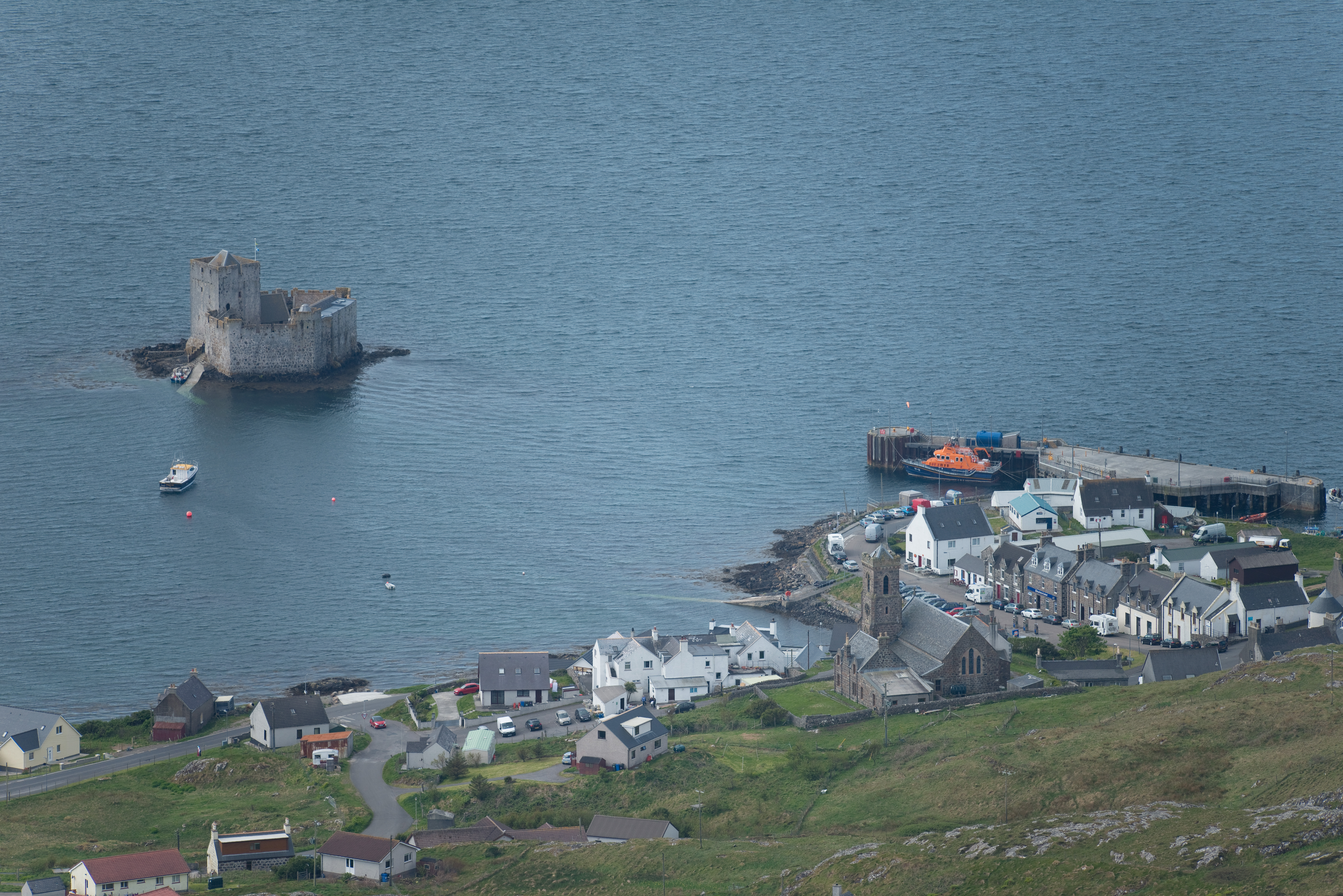
Castlebay is a charming village located on the Isle of Barra in the Outer Hebrides, Scotland. Situated in Inverness-shire, Castlebay is the largest settlement on the island and serves as its main port and commercial center. The village is nestled on the southern coast of Barra, overlooking the beautiful Castlebay Bay and surrounded by stunning natural landscapes.

The village is renowned for its picturesque harbor, which is often dotted with colorful fishing boats and yachts. The pristine sandy beaches of Barra, including the famous Traigh Mhor, are within easy reach from Castlebay, attracting visitors from near and far. Additionally, the village boasts magnificent views of the nearby islands of Vatersay, Sandray, and Pabbay, adding to its allure.

Castlebay offers a range of amenities and services to both residents and visitors. The village is home to a couple of grocery stores, cafes, restaurants, and pubs, providing locals and tourists with essential supplies and dining options. The local community also takes pride in preserving its Gaelic heritage, with the Gaelic language being spoken by a significant portion of the population.

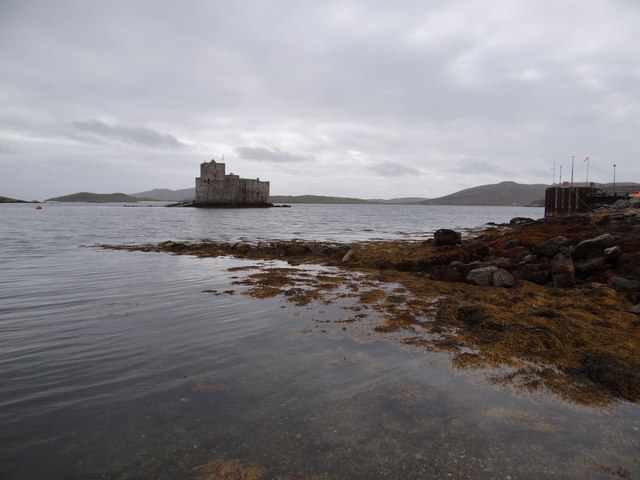
Historically, Castlebay is notable for its iconic Kisimul Castle, a medieval fortress situated on a rocky islet just offshore. The castle, which dates back to the 15th century, has been meticulously restored and stands as a popular tourist attraction, offering insight into the island's rich history and culture.

In conclusion, Castlebay is a scenic village in Inverness-shire, Scotland, offering breathtaking views, access to stunning beaches, a vibrant community, and a fascinating historical landmark in the form of Kisimul Castle.

If you have any feedback on the listing, please let us know in the comments section below.
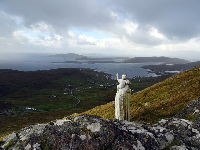
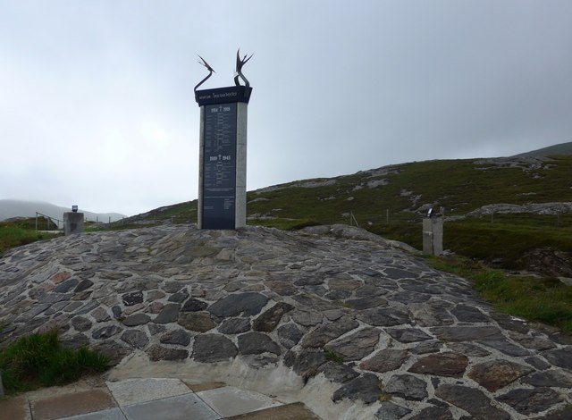
Castlebay Images

Images are sourced within 2km of 56.953652/-7.480629 or Grid Reference NL6698. Thanks to Geograph Open Source API. All images are credited.

Castle in the bay View of Caisteal Chiosmuil from Castlebay.
Castle in the bay
View of Caisteal Chiosmuil from Castlebay.
The Madonna and Child statue on Sheabhal Looking over Castlebay on Barra - quite awe inspiring!
The Madonna and Child statue on Sheabhal
Looking over Castlebay on Barra - quite awe inspiring!
MV Claymore at Castlebay The Caledonian MacBrayne car ferry arrives at Castlebay pier on a still misty Wednesday evening at the end of her 5-hour passage from Oban.  In the 1980s she maintained the triangular route between Lochboisdale, Barra and the mainland, but Uist, being the larger and more populous island, enjoyed many more direct sailings.  The next return sailing on this route will not be until Saturday.

Claymore perpetuated the name of the last of the classic MacBrayne steamers built in 1955 - see <a href="https://www.geograph.org.uk/photo/2341322">NM6797 : SS Claymore at Mallaig bound for Stornoway</a>.  After withdrawal from the CalMac fleet Claymore, in a new livery and by then looking rather dated with her awkward side-loading ramps, saw service on the short-lived Kintyre-Antrim route <a href="https://www.geograph.org.uk/photo/2177551">D1241 : The Campbeltown ferry, Ballycastle</a> and later on the short Pentland Firth crossing from John o' Groats to St Margaret's Hope <a href="https://www.geograph.org.uk/photo/488872">ND4093 : The Bu, Hoxa Head</a>.  She was finally sold to the Danes who renamed her Sia and use her as a cable-laying and supply ship.
MV Claymore at Castlebay
The Caledonian MacBrayne car ferry arrives at Castlebay pier on a still misty Wednesday evening at the end of her 5-hour passage from Oban. In the 1980s she maintained the triangular route between Lochboisdale, Barra and the mainland, but Uist, being the larger and more populous island, enjoyed many more direct sailings. The next return sailing on this route will not be until Saturday. Claymore perpetuated the name of the last of the classic MacBrayne steamers built in 1955 - see NM6797 : SS Claymore at Mallaig bound for Stornoway. After withdrawal from the CalMac fleet Claymore, in a new livery and by then looking rather dated with her awkward side-loading ramps, saw service on the short-lived Kintyre-Antrim route D1241 : The Campbeltown ferry, Ballycastle and later on the short Pentland Firth crossing from John o' Groats to St Margaret's Hope ND4093 : The Bu, Hoxa Head. She was finally sold to the Danes who renamed her Sia and use her as a cable-laying and supply ship.
West slopes of Sheabhal
Bagh a' Chaisteil, Barra
Gleann, Castlebay
Gleann, Castlebay
Camping by the old road to Gleann The southern isles of the Hebrides stretch away to Mingulay and Berneray.
Camping by the old road to Gleann
The southern isles of the Hebrides stretch away to Mingulay and Berneray.
The 'Claymore' berthed at Castlebay, Barra
Trig Point on Heaval, Barra
'Claymore' at Castlebay, Barra
Rivet on rock near Gleann, Barra One of many rivet benchmarks on the island. For full description of benchmark, see <span class="nowrap"><a title="http://www.bench-marks.org.uk/bm76328" rel="nofollow ugc noopener" href="http://www.bench-marks.org.uk/bm76328">Link</a><img style="margin-left:2px;" alt="External link" title="External link - shift click to open in new window" src="https://s1.geograph.org.uk/img/external.png" width="10" height="10"/></span>. See also <a href="https://www.geograph.org.uk/photo/4996737">NL6798 : House near Gleann, Barra</a>.
Rivet on rock near Gleann, Barra
One of many rivet benchmarks on the island. For full description of benchmark, see LinkExternal link. See also NL6798 : House near Gleann, Barra.
House near Gleann, Barra The house and woodland are on the eastern side of the circular road which goes round the island. In the foreground is a rock and just visible in the photo is the Ordnance Survey rivet benchmark which has been borne into the rock. See also <a href="https://www.geograph.org.uk/photo/4996733">NL6798 : Rivet on rock near Gleann, Barra</a>.
House near Gleann, Barra
The house and woodland are on the eastern side of the circular road which goes round the island. In the foreground is a rock and just visible in the photo is the Ordnance Survey rivet benchmark which has been borne into the rock. See also NL6798 : Rivet on rock near Gleann, Barra.
Castlebay harbour on Barra The Caledonian Macbrayne ferry and the lifeboat berthed in Castlebay harbour on the island of Barra, Western Isles.
Castlebay harbour on Barra
The Caledonian Macbrayne ferry and the lifeboat berthed in Castlebay harbour on the island of Barra, Western Isles.
Barra, from over the Sea of the Hebrides With the Atlantic Ocean beyond. South Uist is at upper right. Traigh Mhor beach, which also serves as the airfield, is in the indented bay by the isthmus just right of centre - not active at the time of the photograph, as the tide appears to be in.
Barra, from over the Sea of the Hebrides
With the Atlantic Ocean beyond. South Uist is at upper right. Traigh Mhor beach, which also serves as the airfield, is in the indented bay by the isthmus just right of centre - not active at the time of the photograph, as the tide appears to be in.
War memorial outside Castlebay This is illuminated at night - the lights can be seen on the pillars at rear, although I do not know if they are currently in use.
War memorial outside Castlebay
This is illuminated at night - the lights can be seen on the pillars at rear, although I do not know if they are currently in use.
The Screen Machine is in town! This amazing articulated trailer expands out to become an 80-seat, air conditioned mobile cinema.
The Screen Machine is in town!
This amazing articulated trailer expands out to become an 80-seat, air conditioned mobile cinema.
New pontoon berths at Castlebay The blue buoys are additional mooring for visiting yachts.  But demand these days is more and more for 'step ashore' pontoons.
New pontoon berths at Castlebay
The blue buoys are additional mooring for visiting yachts. But demand these days is more and more for 'step ashore' pontoons.
MV Isle of Lewis, at Castlebay The MV Isle of Lewis (Eilean Leodhais) is now the main vessel on the route from Oban to Castlebay. It arrived at about 1830, and will return the next morning. It is berthed at the main pier, just beside Kisimul Castle (Caisteal Chiosamuil).
MV Isle of Lewis, at Castlebay
The MV Isle of Lewis (Eilean Leodhais) is now the main vessel on the route from Oban to Castlebay. It arrived at about 1830, and will return the next morning. It is berthed at the main pier, just beside Kisimul Castle (Caisteal Chiosamuil).
Show me another place!

Castlebay is located at Grid Ref: NL6698 (Lat: 56.953652, Lng: -7.480629)

Unitary Authority: Na h-Eileanan an Iar

Police Authority: Highlands and Islands

Also known as: Bàgh a'Chaisteil

What 3 Words

///thighs.scar.shrimps. Near CastleBay, Na h-Eileanan Siar

Related Wikis

Castlebay

Castlebay (Scottish Gaelic: Bàgh a' Chaisteil [baːɣ ə ˈxaʃtʲɪl]) is the main village and a community council area on the island of Barra in the Outer Hebrides...

Kisimul Castle

Kisimul Castle (Scottish Gaelic: Caisteal Chiosmuil) and also known as Kiessimul Castle, is a medieval castle located on a small island off Castlebay,...

Barrathon

The Barrathon is an annual half marathon which takes place on the Isle of Barra, which is the southernmost inhabited isle of the Outer Hebrides in Scotland...

Castlebay Community School

Castlebay Community School is a bilingual Gaelic/English school for ages 3–18 on the Scottish island of Barra.In September 2007, it hosted a major tribute...

St Brendan's Hospital, Castlebay

St Brendan's Hospital is a hospital in Castlebay on the island of Barra, Eileanan Siar. It is managed by NHS Western Isles. == History == The current facility...

Heaval

Heaval is the highest hill on the Outer Hebridean island of Barra, Scotland. The highest point is 383 metres high above sea level and it is located 1.5...

Brevig, Barra

Brevig (Scottish Gaelic: Brèibhig) is a village on the island of Barra, in the Outer Hebrides, Scotland. The settlement is situated on the A888, which...

Vatersay Causeway

The Vatersay Causeway (Scottish Gaelic: Rathad Bhàgh Bhatarsaigh) is a 250-metre-long causeway that links the Scottish Hebridean Islands of Vatersay and...

Nearby Amenities

Located within 500m of 56.953652,-7.480629
Telephone
Booth: KX100
Covered: booth
Source: survey
Lat/Long: 56.9550235/-7.4858146
Turning Circle
Lat/Long: 56.9519192/-7.4831422
Passing Place
Lat/Long: 56.9550956/-7.4833527
Passing Place
Lat/Long: 56.9547412/-7.4808728
Passing Place
Lat/Long: 56.9560525/-7.4792701
Bàgh a' Chaisteil
Loc Name: Baile MhicNèill
Name En: Castlebay
Name Gd: Bàgh a' Chaisteil
Name Sco: Castleby
Place: village
Population: 434
Wikidata: Q1049581
Wikipedia: en:Castlebay
Lat/Long: 56.9551221/-7.4859693
Passing Place
Lat/Long: 56.9544726/-7.4830385
Bagh a Chaisteil
Name En: Castlebay
Name Gd: Bagh a Chaisteil
Traffic Sign: city_limit
Lat/Long: 56.9544176/-7.4818608
Ferry Terminal
Lat/Long: 56.9523141/-7.4869121
Ferry Terminal
Cargo: passengers
Lat/Long: 56.9539521/-7.4862161
Leisure: slipway
Seamark Information: by car
Seamark Small Craft Facility Category: slipway
Seamark Type: small_craft_facility
Lat/Long: 56.9543533/-7.4881397
Passing Place
Lat/Long: 56.9549743/-7.4822275
Passing Place
Lat/Long: 56.955317/-7.475016
Passing Place
Lat/Long: 56.9563875/-7.4765098
Restaurant
Cafe Kisimul
Cuisine: curry
Fhrs Id: 806506
Website: https://www.cafekisimul.co.uk/
Lat/Long: 56.9543016/-7.48665
Pub
Castlebay Bar
Lat/Long: 56.9553934/-7.4872449
Restaurant
Restaurant at Castlebay Hotel
Lat/Long: 56.9554843/-7.4878291
Bank
Banca Rìoghail na h-Alba
Addr City: Bàgh a' Chaisteil
Atm: yes
Brand: Royal Bank of Scotland
Name En: Royal Bank of Scotland
Name Gd: Banca Rìoghail na h-Alba
Not Addr Postcode: HS9 5XA
Operator: Royal Bank of Scotland
Website: https://locator-rbs.co.uk/Branch/831703-Castlebay.html
Lat/Long: 56.9545055/-7.4865143
Operator: Caledonian MacBrayne
Shop: travel_agency
Website: https://www.calmac.co.uk/ports/castlebay
Lat/Long: 56.9540986/-7.4875145
Post Office
Oifis a' Phuist Bàgh a' Chaisteil
Addr City: Eilean Bharraigh
Addr City En: Isle of Barra
Addr Country: GB
Addr Postcode: HS9 5XD
Addr Suburb: Bàgh a' Chaisteil
Addr Suburb En: Castlebay
Brand: Post Office
Brand Wikidata: Q1783168
Facebook: https://www.facebook.com/CastlebayPostOffice/
Name En: Castlebay Post Office
Name Gd: Oifis a' Phuist Bàgh a' Chaisteil
Opening Hours: Mo 08:30-17:30; Tu-Fr 09:00-17:30; Sa 09:00-12:30
Ref Pol Id: 3013
Website: https://www.postoffice.co.uk/branch-finder/1528696/castlebay
Lat/Long: 56.9541366/-7.4867402
Post Box
Collection Times: Mo-Fr 10:00; Sa 08:00
Operator: Royal Mail
Post Box Type: pillar
Ref: HS9 13
Royal Cypher: scottish_crown
Lat/Long: 56.9541027/-7.4866295
Toilets
Drinking Water: yes
Fee: no
Wheelchair: yes
Lat/Long: 56.9551971/-7.4862309
Beinn Orasaigh
Ele: 95
Natural: peak
Lat/Long: 56.9505521/-7.4758904
Pub
Craigard Bar
Lat/Long: 56.9548117/-7.4845193
Fuel
A&C Maclean
Addr City: Eilean Bharraigh
Addr City En: Isle of Barra
Addr Country: GB
Addr Postcode: HS9 5XD
Addr Suburb: Bàgh a' Chaisteil
Addr Suburb En: Castlebay
Brand: Gulf
Brand Wikidata: Q5617505
Fhrs Id: 806504
Lat/Long: 56.9545794/-7.4861344
A&C MacLeans
Shop: convenience
Lat/Long: 56.9546232/-7.4864482
Doctors
Clach Mhile Surgery
Website: https://www.barramedicalpractice.co.uk/
Lat/Long: 56.9548855/-7.486335
Charging Station
Access: yes
Capacity: 2
Fee: yes
Operator: ChargePlace Scotland
Operator Wikidata: Q105359316
Ref: 50255
Socket Type2: 1
Socket Type2 Output: 22 kW
Website: https://chargeplacescotland.org/cpmap/chargepoint/1448307/
Lat/Long: 56.9550581/-7.4871199
Ferry Terminal
Ferry: yes
Public Transport: station
Lat/Long: 56.9541171/-7.4884668
Charging Station
Access: yes
Capacity: 2
Fee: yes
Operator: ChargePlace Scotland
Operator Wikidata: Q105359316
Ref: 50646
Website: https://chargeplacescotland.org/cpmap/chargepoint/621126/
Lat/Long: 56.9537995/-7.4873308
Barra Bike Hire
Service Bicycle Rental: yes
Shop: bicycle
Website: https://www.barrabikehire.co.uk
Lat/Long: 56.9552799/-7.488106
Atm
Brand: Royal Bank of Scotland
Operator: Royal Bank of Scotland
Lat/Long: 56.9545274/-7.4864274
An Gleann
Name En: The Glen
Name Gd: An Gleann
Place: hamlet
Lat/Long: 56.9572276/-7.4763375
Information: office
Operator: Buth Bharraigh
Tourism: information
Lat/Long: 56.9553034/-7.4882507
Cafe
Macroon's Tea Room
Outdoor Seating: yes
Lat/Long: 56.9541541/-7.4866902
Top Shop
Operator: A&C MacLean
Shop: convenience
Lat/Long: 56.9552628/-7.4859397
Toilets
Lat/Long: 56.954178/-7.4875298
Power: pole
Lat/Long: 56.9564306/-7.4745119
Power: pole
Lat/Long: 56.9546521/-7.4763156
Power: pole
Lat/Long: 56.9550967/-7.476671
Power: pole
Lat/Long: 56.9561725/-7.475169
Power: pole
Lat/Long: 56.9558141/-7.4761051
Power: pole
Lat/Long: 56.9554872/-7.4769701
Power: pole
Lat/Long: 56.9550543/-7.4780926
Power: pole
Lat/Long: 56.9551662/-7.4791279
Power: pole
Lat/Long: 56.9552774/-7.4801968
Power: pole
Lat/Long: 56.9553893/-7.4813367
Power: pole
Lat/Long: 56.9556745/-7.4822822
Power: pole
Lat/Long: 56.9558843/-7.4830279
Power: pole
Lat/Long: 56.9559194/-7.4838835
Power: pole
Lat/Long: 56.9559575/-7.4848183
Power: pole
Lat/Long: 56.9559955/-7.4857382
Power: pole
Lat/Long: 56.9560489/-7.4872899
Power: pole
Lat/Long: 56.9560182/-7.486563
Power: pole
Lat/Long: 56.9554624/-7.4865228
Passing Place
Lat/Long: 56.9539378/-7.4790755
Leisure: slipway
Lat/Long: 56.952487/-7.4826493
Shelter
Shelter Type: public_transport
Lat/Long: 56.9539471/-7.487139
Edna Windsor
Water Rescue
Emergency: water_rescue
Lifeboat: offshore
Lifeboat Class: RNLI Severn
Operator: Royal National Lifeboat Institution
Operator Short: RNLI
Ref: 17-12
Seamark Name: Edna Windsor
Seamark Radio Station Category: ais
Seamark Radio Station Mmsi: 232003050
Seamark Rescue Station Category: lifeboat_on_mooring
Seamark Source: Bing; https://rnli.org/find-my-nearest
Seamark Type: rescue_station
Website: https://rnli.org/find-my-nearest/lifeboat-stations/barra-island-lifeboat-station/barra-island-lifeboat
Lat/Long: 56.9534915/-7.4877794
Passing Place
Lat/Long: 56.9555406/-7.4800774
Passing Place
Lat/Long: 56.9562293/-7.4776894
Passing Place
Lat/Long: 56.9543208/-7.47925
Passing Place
Lat/Long: 56.9547625/-7.4770814
Passing Place
Lat/Long: 56.9550115/-7.476144
Passing Place
Lat/Long: 56.9551439/-7.4756404
Barrier: cattle_grid
Lat/Long: 56.9552256/-7.4749357
Power: pole
Lat/Long: 56.9554519/-7.4843186
Power: pole
Lat/Long: 56.9553094/-7.4824328
Power: pole
Lat/Long: 56.9549137/-7.4821314
Leideag
Name En: Ledaig
Name Gd: Leideag
Place: hamlet
Lat/Long: 56.9524064/-7.4817946
Gearraidh Gadhal
Name En: Garrygall
Name Gd: Gearraidh Gadhal
Place: hamlet
Lat/Long: 56.9553434/-7.4733832
Power: pole
Lat/Long: 56.9544053/-7.4797771
Power: pole
Lat/Long: 56.9538735/-7.4795163
Power: pole
Lat/Long: 56.953695/-7.4790433
Power: pole
Lat/Long: 56.9533415/-7.4792672
Power: pole
Lat/Long: 56.9529062/-7.4798352
Power: pole
Lat/Long: 56.9523055/-7.4805098
Power: pole
Lat/Long: 56.9516176/-7.4812437
Power: pole
Lat/Long: 56.9509601/-7.4818413
Power: pole
Lat/Long: 56.9503025/-7.4824663
Power: pole
Lat/Long: 56.9495079/-7.4824431
Power: pole
Lat/Long: 56.9519429/-7.4824639
Power: pole
Lat/Long: 56.952043/-7.481919
Power: pole
Lat/Long: 56.9521784/-7.4811783
Power: pole
Lat/Long: 56.9530421/-7.4808467
Power: pole
Lat/Long: 56.9564735/-7.4824389
Power: pole
Lat/Long: 56.9562617/-7.4824536
Power: pole
Lat/Long: 56.9557316/-7.4824853
Telephone
Booth: KX100
Covered: booth
Source: survey
Lat/Long: 56.9550116/-7.485833
Bus Stop
Co-Op
Bus: yes
Public Transport: platform
Lat/Long: 56.9551339/-7.4879515
Bus Stop
The Square
Bus: yes
Naptan AtcoCode: 601058
Naptan NaptanCode: 94724593
Public Transport: platform
Lat/Long: 56.9549551/-7.4860914
Barrier: cattle_grid
Lat/Long: 56.9547313/-7.4840891
Barrier: cattle_grid
Lat/Long: 56.9553793/-7.4738363
Generator Method: photovoltaic
Generator Output Electricity: small_installation
Generator Source: solar
Generator Type: solar_photovoltaic_panel
Power: generator
Lat/Long: 56.9550928/-7.4813691
Passing Place
Lat/Long: 56.9557805/-7.4817823
Passing Place
Lat/Long: 56.9561327/-7.4822507
Turning Circle
Turning Circle: knuckle
Lat/Long: 56.9563704/-7.4823497
Turning Circle
Turning Circle: knuckle
Lat/Long: 56.955506/-7.4822206
Power: pole
Lat/Long: 56.9549112/-7.4800206
Turning Circle
Turning Circle: knuckle
Lat/Long: 56.9541337/-7.4766653
Power: pole
Lat/Long: 56.9545304/-7.4766499
Power: pole
Lat/Long: 56.9548061/-7.4754925
Power: pole
Lat/Long: 56.9549436/-7.474767
Power: pole
Lat/Long: 56.9519943/-7.4801538
Waste Basket
Lat/Long: 56.9550114/-7.4858797
Waste Basket
Lat/Long: 56.9550708/-7.4865337
Bus Stop
Craigard Hotel
Bus: yes
Public Transport: platform
Lat/Long: 56.9548793/-7.4853575
Bus Stop
Craigard Hotel
Bus: yes
Public Transport: platform
Lat/Long: 56.954911/-7.4852514
Bus Stop
Post Office
Bus: yes
Public Transport: platform
Lat/Long: 56.9540803/-7.4864731
Bus Stop
Ledaig Rd End
Bus: yes
Public Transport: platform
Lat/Long: 56.9543991/-7.4815609
Bus Stop
Ledaig Rd End
Bus: yes
Public Transport: platform
Lat/Long: 56.9543423/-7.4816199
Bus Stop
Garrygall Rd End
Bus: yes
Public Transport: platform
Lat/Long: 56.9547957/-7.4767839
Bus Stop
Garrygall Rd End
Bus: yes
Public Transport: platform
Lat/Long: 56.9548367/-7.4768886
The data included in this document is from www.openstreetmap.org. The data is made available under ODbL.

Have you been to Castlebay?

Leave your review of Castlebay below (or comments, questions and feedback).