Barhapple Moor

Downs, Moorland in Wigtownshire

Scotland

Barhapple Moor

Wall and fence-lined minor road between High Mindork and Barnearnie Looking north-eastward.
Wall and fence-lined minor road between High Mindork and Barnearnie Credit: Peter Wood

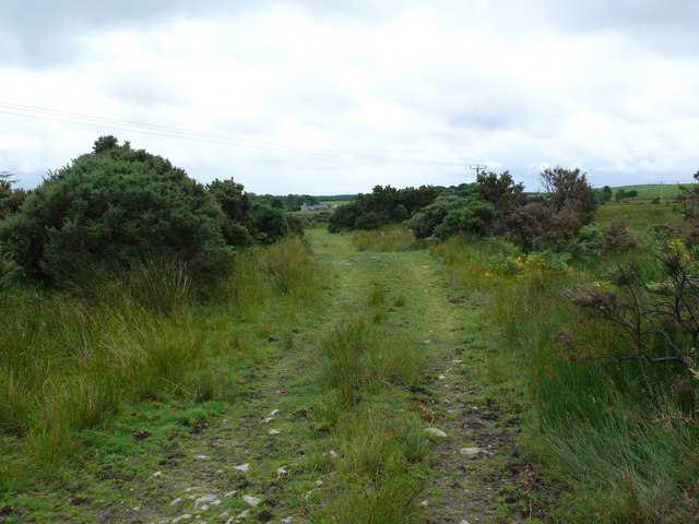
Barhapple Moor is a picturesque expanse of downs and moorland located in Wigtownshire, Scotland. Covering an area of approximately 500 acres, this natural landscape is renowned for its beauty and tranquility. The moor is situated in the heart of the Galloway Hills, offering visitors breathtaking panoramic views of the surrounding countryside.

The terrain of Barhapple Moor is characterized by undulating hills, heather-covered slopes, and patches of boggy ground, creating a diverse and unique ecosystem. The moorland is home to an array of flora and fauna, including heather, mosses, and wildflowers, as well as various species of birds such as curlews, lapwings, and red grouse.

Visitors to Barhapple Moor can enjoy a variety of outdoor activities, including hiking, birdwatching, and nature photography. There are several well-marked trails that wind through the moor, allowing visitors to explore its natural wonders at their own pace. The open expanses of the moor also make it an ideal location for picnicking and taking in the scenic beauty of the surrounding landscape.

Barhapple Moor is easily accessible by car, with a parking area provided for visitors. The moor is located just a short distance from the village of Newton Stewart, where visitors can find amenities such as accommodation, dining options, and local shops.

Overall, Barhapple Moor is a must-visit destination for nature enthusiasts and those seeking a peaceful retreat in the heart of the Scottish countryside. Its stunning vistas, diverse wildlife, and serene atmosphere make it a truly enchanting place to explore.

If you have any feedback on the listing, please let us know in the comments section below.

Barhapple Moor Images

Images are sourced within 2km of 54.911211/-4.656144 or Grid Reference NX2960. Thanks to Geograph Open Source API. All images are credited.

Wall and fence-lined minor road between High Mindork and Barnearnie Looking north-eastward.
Wall and fence-lined minor road between High Mindork and Barnearnie
Looking north-eastward.
Old milestone A short distance from this milestone can be seen the road sign for the A75 and the Give Way sign.   This is the last of a complete set of 10 milestones on the B733 from Wigtown 0.   It is now 8 miles of A75, new and old sections, into Glenluce.
Old milestone
A short distance from this milestone can be seen the road sign for the A75 and the Give Way sign. This is the last of a complete set of 10 milestones on the B733 from Wigtown 0. It is now 8 miles of A75, new and old sections, into Glenluce.
Old milestone From this photograph it can be seen that the milestone has, at some time, been reset with the W face to the road.  And it has been painted since 2008 when first recorded for the Milestone Society.
Old milestone
From this photograph it can be seen that the milestone has, at some time, been reset with the W face to the road. And it has been painted since 2008 when first recorded for the Milestone Society.
Farmland near Muil Farm The ridge is called Near Barbunny - barr buin duibh - the hill of the black bottom, or bog.
Farmland near Muil Farm
The ridge is called Near Barbunny - barr buin duibh - the hill of the black bottom, or bog.
The old military road near Kiltersan Built in the 18th century, it runs to the port at Portpatrick. It was constructed so that troops could be moved quickly to Ireland in times of trouble.
The old military road near Kiltersan
Built in the 18th century, it runs to the port at Portpatrick. It was constructed so that troops could be moved quickly to Ireland in times of trouble.
Kiltersan Kiltersan - Cill tarsuinn - means the chapel at the crossing, although the crossing of what isn't obvious.
Kiltersan
Kiltersan - Cill tarsuinn - means the chapel at the crossing, although the crossing of what isn't obvious.
Muil farm and the A75 The work taking place behind the farm is in connection with a new water mains being run across the breadth of the county.
Muil farm and the A75
The work taking place behind the farm is in connection with a new water mains being run across the breadth of the county.
Field gate, moor and forestry near Muil farm
Kiltersan Farm from the Gargrie Taken at dusk. Kiltersan farm is in the middle distance. The hill on the horizon is the Knock of Luce.
Kiltersan Farm from the Gargrie
Taken at dusk. Kiltersan farm is in the middle distance. The hill on the horizon is the Knock of Luce.
Stones of Kiltersan Looking due east along the Old Military Road.
Stones of Kiltersan
Looking due east along the Old Military Road.
Winter at Kiltersan
Winter at Kiltersan
Kiltersan Farm Looking towards Kiltersan Farm and reservoir from the Old Military Road
Kiltersan Farm
Looking towards Kiltersan Farm and reservoir from the Old Military Road
Knockbreck View from this hill, which is one of the highest in this grid, towards Barmore Farm.
Knockbreck
View from this hill, which is one of the highest in this grid, towards Barmore Farm.
Military Road This track forms part of the old military road and looks towards Kiltersan.
Military Road
This track forms part of the old military road and looks towards Kiltersan.
Knockbreck View north from this hill which is mainly open grasslands for sheep farming.
Knockbreck
View north from this hill which is mainly open grasslands for sheep farming.
Knockbreck View south from this hill across the A75 centre of picture towards Mark of Luce Moss on the horizon and Mark of Luce Farm left of the Moss.
Knockbreck
View south from this hill across the A75 centre of picture towards Mark of Luce Moss on the horizon and Mark of Luce Farm left of the Moss.
Knockbreck View east past the power lines and masts that run for miles through this open countryside.
Knockbreck
View east past the power lines and masts that run for miles through this open countryside.
Knockbreck View west from this hill across open countryside, Barmore Farm can be seen left of picture.
Knockbreck
View west from this hill across open countryside, Barmore Farm can be seen left of picture.
Show me another place!

Barhapple Moor is located at Grid Ref: NX2960 (Lat: 54.911211, Lng: -4.656144)

Unitary Authority: Dumfries and Galloway

Police Authority: Dumfries and Galloway

What 3 Words

///theory.aspect.porch. Near Newton Stewart, Dumfries & Galloway

Related Wikis

Kirkcowan railway station

Kirkcowan railway station served the village of Kirkcowan, Dumfries and Galloway, Scotland from 1861 to 1965 on the Portpatrick and Wigtownshire Joint...

Kirkcowan

Kirkcowan is an area about 15 miles in length, and from nearly two to nearly seven miles in breadth, comprising 30,580 acres, of which 7000 are arable...

Barhapple Loch

Barhapple Loch is a small semicircular freshwater loch located in Wigtownshire, Dumfries and Galloway in Scotland. Barhapple Loch is principally known...

Tarf Water, Wigtownshire

The Tarf Water is a river in the former county of Wigtownshire in south-west Scotland. It rises on the Ayrshire border (55.0048°N 4.7815°W / 55.0048;...

Have you been to Barhapple Moor?

Leave your review of Barhapple Moor below (or comments, questions and feedback).