Dail an t-Suidhe

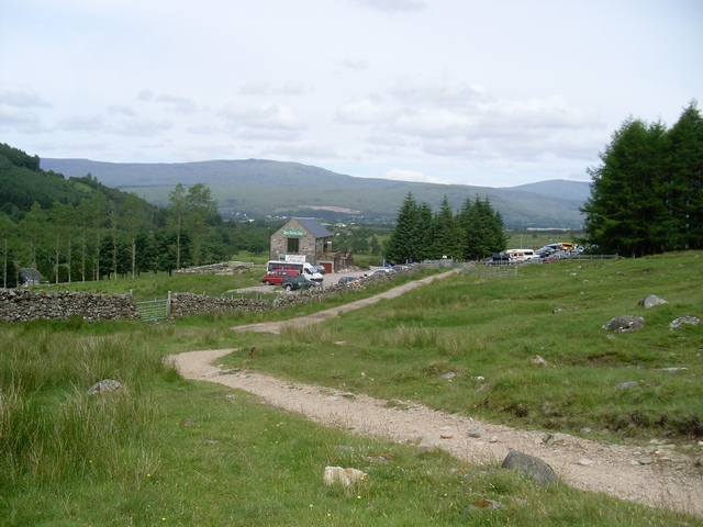
Downs, Moorland in Inverness-shire

Scotland

Dail an t-Suidhe

Railway siding, Lochaber Smelter
Railway siding, Lochaber Smelter Credit: Steven Brown

Dail an t-Suidhe is a picturesque area located in Inverness-shire, Scotland. Situated in the heart of the Highlands, it is characterized by its stunning landscape of downs and moorland. The name "Dail an t-Suidhe" translates to "Field of the Seat" in Gaelic, hinting at the historical significance and natural beauty of the area.

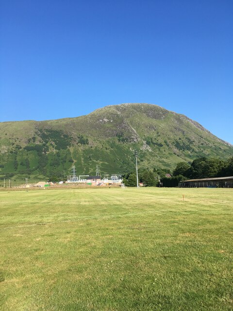
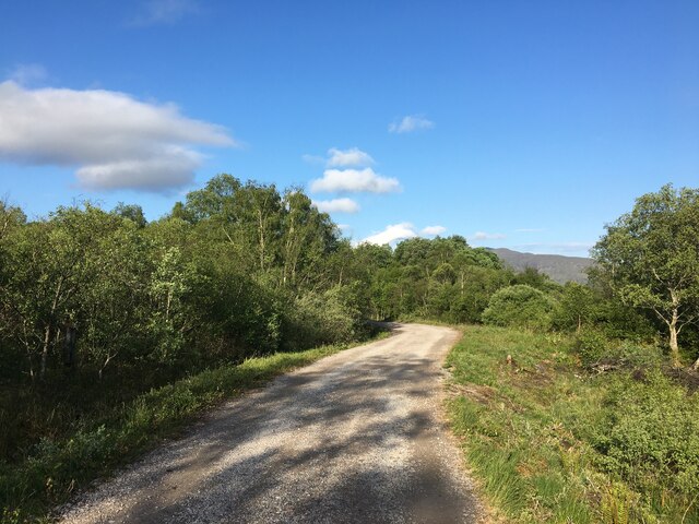
The downs of Dail an t-Suidhe are vast grassy plains that stretch out for miles, offering panoramic views of the surrounding mountains and valleys. These downs are home to a variety of plant and animal species, including heather, bracken, and various bird species. The moorland, on the other hand, is characterized by its boggy terrain, dotted with peat hags and heather.

The area is a popular destination for outdoor enthusiasts and nature lovers alike. Visitors can enjoy leisurely walks or hikes across the downs, taking in the breathtaking scenery and immersing themselves in the tranquility of the surroundings. The moorland also offers opportunities for birdwatching and wildlife spotting, with the chance to see species such as red grouse, golden eagles, and red deer.

Dail an t-Suidhe is also steeped in history, with ancient ruins and archaeological sites scattered throughout the area. These remnants of the past offer a glimpse into the lives of the people who once inhabited this land.

Overall, Dail an t-Suidhe is a captivating destination that showcases the natural beauty and rich history of the Scottish Highlands.

If you have any feedback on the listing, please let us know in the comments section below.

Dail an t-Suidhe Images

Images are sourced within 2km of 56.813178/-5.0739444 or Grid Reference NN1273. Thanks to Geograph Open Source API. All images are credited.

Railway siding, Lochaber Smelter
Peat Track, Cow Hill
Claggan Park
Claggan Park
Morris Marina door in woodland near the Aluminium Works, Fort William
Picnic area near the car park
Gravel road near the aluminium smelter
Rough path up Creag a’ Chail
Northern slopes of Meall an t-Suidhe looking towards Ben Nevis
Supermarket, North Road Retail Park
Footpath near Cow Hill
Path in forestry on Cow Hill
Playing field at Inverlochy The path in the foreground is General Wade's Military Road.
Playing field at Inverlochy
The path in the foreground is General Wade's Military Road.
The Jacobite  (aka Hogwarts Express) Fort William Station is the end of the West Highland Line. The present station dates from 1975.
The Jacobite (aka Hogwarts Express)
Fort William Station is the end of the West Highland Line. The present station dates from 1975.
Lochan Meall an t-Suidhe
Sparse trees on Cow Hill Head of Loch Linnhe and Banavie in the distance.
Sparse trees on Cow Hill
Head of Loch Linnhe and Banavie in the distance.
There are plenty of cycles at Nevis Cycles!
Tourist Path up Ben Nevis The Tourist Path leads up Ben Nevis from Achintee but do not be misled by the name for this is an arduous hike which, while not technically difficult, can take as long as four hours to reach the top of Ben Nevis, the UK's highest mountain. Stob Ban is the mountain in view on the right partly in sunlight.
Tourist Path up Ben Nevis
The Tourist Path leads up Ben Nevis from Achintee but do not be misled by the name for this is an arduous hike which, while not technically difficult, can take as long as four hours to reach the top of Ben Nevis, the UK's highest mountain. Stob Ban is the mountain in view on the right partly in sunlight.
Wooden footbridge on the Tourist Path Crossing a gorge on the way up.  Photo taken around 7am so the track is in shade and the day is relatively cool still but it was very warm later.
Wooden footbridge on the Tourist Path
Crossing a gorge on the way up. Photo taken around 7am so the track is in shade and the day is relatively cool still but it was very warm later.
Show me another place!

Dail an t-Suidhe is located at Grid Ref: NN1273 (Lat: 56.813178, Lng: -5.0739444)

Unitary Authority: Highland

Police Authority: Highlands and Islands

What 3 Words

///ledge.diplomat.jammy. Near Fort William, Highland

Nearby Locations

Dail an t-Suidhe

Related Wikis

Achintee, Fort William

Achintee (Scottish Gaelic: Achadh an t-Suidhe) is a location in Glen Nevis in the Highland council area of Scotland. It is around 2 km south-east of Fort...

Claggan Park

Claggan Park is a football ground in Fort William in the West Highlands of Scotland, which is the home ground of North Caledonian League side Fort William...

Meall an t-Suidhe

The Meall an t-Suidhe is a mountain in Scotland, located close to the Ben Nevis. == Etymology == Meall an t-Suidhe is a gaelic toponym which can be translated...

Nevis Radio

Nevis Community Radio Ltd (Nevis Radio) is a community radio station broadcasting from Fort William in Scotland, serving the communities of Fort William...

Nearby Amenities

Located within 500m of 56.813178,-5.0739444
Achintee
Name Gd: Achadh an t-Suidhe
Place: hamlet
Source: OS_OpenData_StreetView
Lat/Long: 56.8109246/-5.072503
Dail an t'Suidhe
Place: locality
Lat/Long: 56.8138213/-5.074519
Cnocan a' Bhuachaille
Place: locality
Lat/Long: 56.8140328/-5.0661095
Barrier: stile
Foot: yes
Lat/Long: 56.8092414/-5.0717366
Mountain Rescue Charity Box
Man Made: buoy
Source: Bing
Lat/Long: 56.809278/-5.0712765
Clach Mhic Shomairle
Natural: rock
Lat/Long: 56.8152967/-5.0766119
Entrance: main
Lat/Long: 56.8100277/-5.0767157
Toilets
Wheelchair: yes
Lat/Long: 56.8100951/-5.0769751
Tourism: hotel
Lat/Long: 56.8116566/-5.0777517
Leisure: picnic_table
Lat/Long: 56.8152651/-5.0784686
Leisure: picnic_table
Lat/Long: 56.8150493/-5.0793967
Leisure: picnic_table
Lat/Long: 56.8149392/-5.0792545
Bench
Lat/Long: 56.8123168/-5.076764
Ford: yes
Lat/Long: 56.8131731/-5.077392
Power: pole
Lat/Long: 56.8097828/-5.0787074
Power: pole
Lat/Long: 56.8103508/-5.0783042
Power: pole
Lat/Long: 56.8109679/-5.0777874
Power: pole
Lat/Long: 56.8114876/-5.0775878
Power: pole
Lat/Long: 56.8123716/-5.0773451
Power: pole
Lat/Long: 56.8129052/-5.0771885
Power: pole
Lat/Long: 56.8133252/-5.077071
Power: pole
Lat/Long: 56.8141952/-5.0768831
Power: pole
Lat/Long: 56.8149141/-5.076795
Material: wood
Power: pole
Lat/Long: 56.8156876/-5.0767892
Material: wood
Power: pole
Lat/Long: 56.8163176/-5.0780282
Tourism: picnic_site
Lat/Long: 56.8100808/-5.0767498
The data included in this document is from www.openstreetmap.org. The data is made available under ODbL.

Have you been to Dail an t-Suidhe?

Leave your review of Dail an t-Suidhe below (or comments, questions and feedback).