Braes of Balker

Downs, Moorland in Wigtownshire

Scotland

Braes of Balker

Storm damage in the woods at High Craigcaffie
Storm damage in the woods at High Craigcaffie Credit: Oliver Dixon

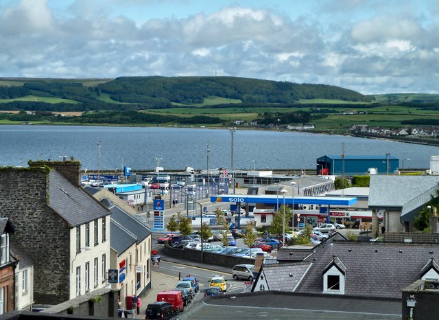
Braes of Balker, located in Wigtownshire, is a picturesque area characterized by its enchanting downs and moorland landscapes. Situated in southwest Scotland, it boasts an abundance of natural beauty and diverse ecosystems.

The downs of Braes of Balker are gently undulating hills, covered with lush green grass and dotted with wildflowers during the warmer months. The area offers breathtaking panoramic views of the surrounding countryside, with its rolling hills and distant mountain ranges. These downs provide an ideal habitat for a variety of wildlife, including grazing sheep and cattle, as well as numerous bird species.

Adjacent to the downs, the moorland of Braes of Balker offers a unique and rugged beauty. Here, the landscape transforms into a wilder terrain, characterized by heather-covered hills, scattered boulders, and patches of low-lying marshland. The moorland is a haven for various bird species, such as curlews, lapwings, and red grouse, making it a popular destination for birdwatchers and nature enthusiasts.

Visitors to Braes of Balker can explore the area through several well-marked walking trails, which allow them to immerse themselves in the natural splendor of the downs and moorland. The landscape offers a sense of tranquility and solitude, making it a perfect destination for those seeking a peaceful retreat or an escape from the hustle and bustle of everyday life.

Braes of Balker is a hidden gem in Wigtownshire, offering a unique combination of downs and moorland that showcases the stunning beauty of Scotland's natural landscapes.

If you have any feedback on the listing, please let us know in the comments section below.

Braes of Balker Images

Images are sourced within 2km of 54.934577/-4.961971 or Grid Reference NX1064. Thanks to Geograph Open Source API. All images are credited.

Storm damage in the woods at High Craigcaffie
Relics of bombing range This massive concrete wall (partly obscured by more recent buildings) and arrow were part of a WWII bombing range and can be seen just off the road from Innermessan to Penwhirn.
Relics of bombing range
This massive concrete wall (partly obscured by more recent buildings) and arrow were part of a WWII bombing range and can be seen just off the road from Innermessan to Penwhirn.
World War II Bombing Range A closer view of the massive concrete wall which formed part of a World War II bombing range just off the road from Innermessan to Penwhirn. More modern structures of unknown purpose have been built on the south side of the wall.
World War II Bombing Range
A closer view of the massive concrete wall which formed part of a World War II bombing range just off the road from Innermessan to Penwhirn. More modern structures of unknown purpose have been built on the south side of the wall.
Top of the woods by High Craigcaffie Seen from the lower slopes of Braid Fell.
Top of the woods by High Craigcaffie
Seen from the lower slopes of Braid Fell.
Wall at bombing range on Braid Fell This huge wall is the dominant structure of the World War II bombing range.
Wall at bombing range on Braid Fell
This huge wall is the dominant structure of the World War II bombing range.
Balker farmhouse and buildings
Cattle Grid One of many on the way to Penwhirn Reservoir.
Cattle Grid
One of many on the way to Penwhirn Reservoir.
Balker Lodge Balker Lodge is situated in the Stairs Estate NW of Lochinch Castle at Castle Kennedy.
Balker Lodge
Balker Lodge is situated in the Stairs Estate NW of Lochinch Castle at Castle Kennedy.
Balker Bridge View N over Balker Bridge towards the Bank of Balker woodlands. Situation within the Stairs Estate, NW of Lochinch Castle.
Balker Bridge
View N over Balker Bridge towards the Bank of Balker woodlands. Situation within the Stairs Estate, NW of Lochinch Castle.
Coigny Clump, Balker View across Coigny Clump towards Balker Wood and other woodlands.  Situation in Stairs Estate and NW of Lochinch Castle.
Coigny Clump, Balker
View across Coigny Clump towards Balker Wood and other woodlands. Situation in Stairs Estate and NW of Lochinch Castle.
Craig Caffie Tower near Innermessan, Stranraer Craig Caffie Tower was built around 1580 near Innermessan, the former capital of the Rhins of Galloway.
Craig Caffie Tower near Innermessan, Stranraer
Craig Caffie Tower was built around 1580 near Innermessan, the former capital of the Rhins of Galloway.
On the A77 north of Stranraer On the busy A77 Glasgow to Stranraer road just north of the junction with the A751. This is clearly a modern stretch of road; the 1940 map shows the road following a sharp loop to the west
On the A77 north of Stranraer
On the busy A77 Glasgow to Stranraer road just north of the junction with the A751. This is clearly a modern stretch of road; the 1940 map shows the road following a sharp loop to the west
Farm road on the Castle Kennedy estate
Bungalow above Craigcaffie This bungalow stands high on the hillside with a magnificent view of Loch Ryan (see other photo for this square)
Bungalow above Craigcaffie
This bungalow stands high on the hillside with a magnificent view of Loch Ryan (see other photo for this square)
View of Loch Ryan from the bungalow above Craigcaffie
Old road at Innermessan Seen from the junction of the A77 and A751. Possibly this old road was the original course of the A77 trunk road from central Scotland to Stranraer. The sea lies just beyond the low hill in the background.
Old road at Innermessan
Seen from the junction of the A77 and A751. Possibly this old road was the original course of the A77 trunk road from central Scotland to Stranraer. The sea lies just beyond the low hill in the background.
High Craigcaffie Situated on a hillside high above Loch Ryan.
High Craigcaffie
Situated on a hillside high above Loch Ryan.
Road Hog Move over and let me by. A van and trailer travelling along the A751 towards Dumfries
Road Hog
Move over and let me by. A van and trailer travelling along the A751 towards Dumfries
Show me another place!

Braes of Balker is located at Grid Ref: NX1064 (Lat: 54.934577, Lng: -4.961971)

Unitary Authority: Dumfries and Galloway

Police Authority: Dumfries and Galloway

What 3 Words

///stuffy.cave.undercuts. Near Cairnryan, Dumfries & Galloway

Related Wikis

Inch, Dumfries and Galloway

Inch is a civil parish in Dumfries and Galloway, southwest Scotland. It lies on the shore of Loch Ryan, in the traditional county of Wigtownshire.The...

Castle Kennedy (castle)

Castle Kennedy is a ruined 17th-century tower house, about 3 miles (4.8 km) east of Stranraer, Dumfries and Galloway, Scotland, around 0.5 miles (0.80...

Aird, Dumfries and Galloway

Aird (Gaelic:An Àird) is a village in Dumfries and Galloway, in the southwest of Scotland. It is 2.5 miles (4.0 km) east of Stranraer and 1 mile (1.6 km...
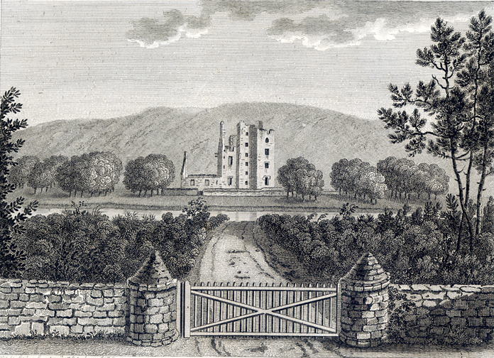
Castle Kennedy

Castle Kennedy is a small village 3 miles (4.8 km) east of Stranraer in Dumfries and Galloway, south-west Scotland. It is on the A75 road, and is within...

RAF Castle Kennedy

Royal Air Force Castle Kennedy, or more simply RAF Castle Kennedy, is a former Royal Air Force satellite station located in Castle Kennedy, Dumfries and...

Castle Kennedy railway station

Castle Kennedy railway station served the village of Castle Kennedy, Dumfries and Galloway, Scotland from 1861 to 1965 on the Portpatrick and Wigtownshire...

Stair Park

Stair Park is a public park and football stadium in the town of Stranraer, Scotland and is the home of Stranraer F.C. It is owned by Dumfries and Galloway...

Stranraer railway station

Stranraer railway station (formerly known as Stranraer Harbour railway station) is a railway station that serves the town of Stranraer, Dumfries and Galloway...

Nearby Amenities

Located within 500m of 54.934577,-4.961971
Teroy Fort
Alt Name: Craigcaffie
Archaeological Site: fortification
Fortification Type: broch
Historic: archaeological_site
Historic Civilization: prehistoric
Historic Period: iron-age
Lat/Long: 54.9353116/-4.9686755
The data included in this document is from www.openstreetmap.org. The data is made available under ODbL.

Have you been to Braes of Balker?

Leave your review of Braes of Balker below (or comments, questions and feedback).