Grunsagill

Settlement in Yorkshire Ribble Valley

England

Grunsagill

Ordnance Survey Cut Mark This mark can be found on the wall of a roadside barn at Grunsagill.
The benchmark has a recorded height of 175.6426 metres above sea level.
For more detail see : <span class="nowrap"><a title="https://www.bench-marks.org.uk/bm152220" rel="nofollow ugc noopener" href="https://www.bench-marks.org.uk/bm152220">Link</a><img style="margin-left:2px;" alt="External link" title="External link - shift click to open in new window" src="https://s1.geograph.org.uk/img/external.png" width="10" height="10"/></span>
Ordnance Survey Cut Mark Credit: Peter Wood

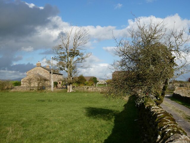
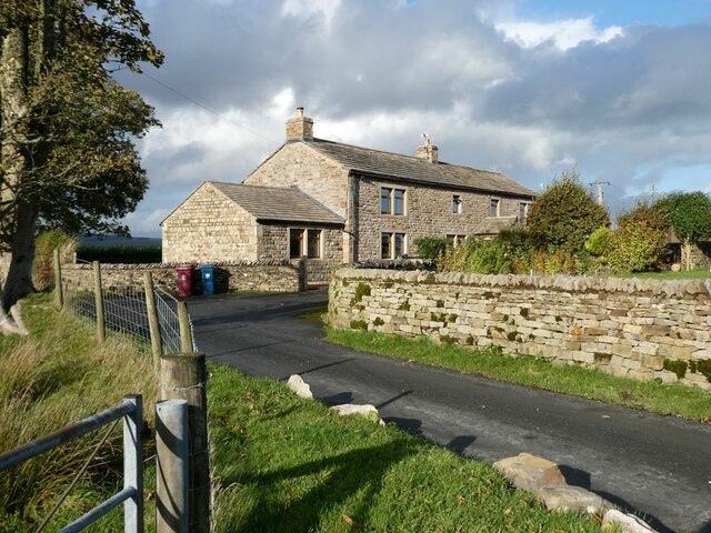
Grunzagill is a picturesque village situated in the heart of the Yorkshire Dales in England. With a population of around 200 residents, it is a small and close-knit community that embodies the charm and tranquility of rural Yorkshire.

Nestled in a valley surrounded by rolling hills and meandering rivers, Grunsagill offers breathtaking views of the countryside. The village is characterized by its traditional stone-built houses, many of which date back centuries, adding to its historical appeal. The narrow lanes are lined with vibrant flower gardens, creating a colorful and welcoming atmosphere.

Despite its remote location, Grunsagill boasts a strong sense of community spirit. The village has a local pub, The Red Lion, serving a selection of traditional ales and hearty meals. It acts as a social hub, hosting events and gatherings that bring the villagers together.

The surrounding countryside provides ample opportunities for outdoor activities. Hiking and cycling enthusiasts can explore the numerous trails that wind through the Dales, offering stunning views and encounters with local wildlife. The nearby River Aire is popular among anglers, attracting those seeking a peaceful fishing experience.

Grunzagill is also within close proximity to other notable attractions in Yorkshire. The bustling market town of Skipton is just a short drive away, offering a range of amenities including shops, restaurants, and a historic castle.

In conclusion, Grunsagill offers a tranquil and idyllic setting for those seeking a peaceful retreat in the heart of the Yorkshire Dales. Its natural beauty, historical charm, and strong community spirit make it a truly special place to visit or call home.

If you have any feedback on the listing, please let us know in the comments section below.

Grunsagill Images

Images are sourced within 2km of 53.983839/-2.334696 or Grid Reference SD7854. Thanks to Geograph Open Source API. All images are credited.

Ordnance Survey Cut Mark This mark can be found on the wall of a roadside barn at Grunsagill.
The benchmark has a recorded height of 175.6426 metres above sea level.
For more detail see : <span class="nowrap"><a title="https://www.bench-marks.org.uk/bm152220" rel="nofollow ugc noopener" href="https://www.bench-marks.org.uk/bm152220">Link</a><img style="margin-left:2px;" alt="External link" title="External link - shift click to open in new window" src="https://s1.geograph.org.uk/img/external.png" width="10" height="10"/></span>
Ordnance Survey Cut Mark
This mark can be found on the wall of a roadside barn at Grunsagill. The benchmark has a recorded height of 175.6426 metres above sea level. For more detail see : LinkExternal link
Ordnance Survey Cut Mark This mark can be found on the parapet wall of a road bridge at Grunasgill.
The benchmark has a recorded height of 184.7302 metres above sea level.
For more detail see : <span class="nowrap"><a title="https://www.bench-marks.org.uk/bm152234" rel="nofollow ugc noopener" href="https://www.bench-marks.org.uk/bm152234">Link</a><img style="margin-left:2px;" alt="External link" title="External link - shift click to open in new window" src="https://s1.geograph.org.uk/img/external.png" width="10" height="10"/></span>
Ordnance Survey Cut Mark
This mark can be found on the parapet wall of a road bridge at Grunasgill. The benchmark has a recorded height of 184.7302 metres above sea level. For more detail see : LinkExternal link
Field near Pendle View Farm As its name implies, Pendle View Farm (shown on the map as Cracoe Hill Farm) has a cracking view of Pendle Hill <a href="https://www.geograph.org.uk/gridref/SD8041">SD8041</a> seen on the horizon.
Field near Pendle View Farm
As its name implies, Pendle View Farm (shown on the map as Cracoe Hill Farm) has a cracking view of Pendle Hill SD8041 seen on the horizon.
The road to Tosside Looking north.
The road to Tosside
Looking north.
Knotts Rest Self-catering accommodation in barn conversion at Knotts Farm.
Knotts Rest
Self-catering accommodation in barn conversion at Knotts Farm.
Field with sheep behind Knotts Farm Under a threatening sky.
Field with sheep behind Knotts Farm
Under a threatening sky.
Moor Stones Barn Farm On Knotts Lane, seen from the drive to Knotts Farm.
Moor Stones Barn Farm
On Knotts Lane, seen from the drive to Knotts Farm.
Moor Stones Barn Farm On Knotts Lane.
Moor Stones Barn Farm
On Knotts Lane.
Knotts Farm
Knotts Farm
Ash tree, cabin and sheep Near Springside Farm on Knotts Lane.
Ash tree, cabin and sheep
Near Springside Farm on Knotts Lane.
Knotts Lane Sunny intervals and black clouds looming.
Knotts Lane
Sunny intervals and black clouds looming.
Field beside Knotts Lane On the lower slopes of Knotts Hill.
Field beside Knotts Lane
On the lower slopes of Knotts Hill.
Bin day At the head of the drive to Little Holme Farm and Big Holme Farm on Knotts Lane.
Bin day
At the head of the drive to Little Holme Farm and Big Holme Farm on Knotts Lane.
View from Knotts Lane Looking across the broad valley of the Holden Beck.
View from Knotts Lane
Looking across the broad valley of the Holden Beck.
Trees beside Knotts Lane
Highland cow Boococks Farm in the background.
Highland cow
Boococks Farm in the background.
Highland cattle near Boococks Farm
To Bowland Fell The access road for this Yorkshire holiday park.
To Bowland Fell
The access road for this Yorkshire holiday park.
Show me another place!

Grunsagill is located at Grid Ref: SD7854 (Lat: 53.983839, Lng: -2.334696)

Division: West Riding

Administrative County: Lancashire

District: Ribble Valley

Police Authority: Lancashire

What 3 Words

///pairings.nowadays.registry. Near Hellifield, North Yorkshire

Related Wikis

Manor House, Gisburn Forest

Manor House is an historic building in Gisburn Forest, Lancashire, England. It was built in the early 18th century, but contains a section that is believed...

Gisburn Forest

Gisburn Forest is a civil parish in the Ribble Valley, in Lancashire, England. Mainly lying within the Forest of Bowland Area of Outstanding Natural Beauty...

Tosside

Tosside is a small village on the modern border of North Yorkshire and Lancashire in Northern England. It lies within the Forest of Bowland, and is between...

Wigglesworth

Wigglesworth is a village and civil parish in the Craven district of North Yorkshire, England. The population of the civil parish taken at the 2011 Census...

Bolton-by-Bowland

Bolton-by-Bowland is a village and civil parish in the Ribble Valley district of Lancashire, England. Before 1974, the village was part of Bowland Rural...

Easington, Lancashire

Easington () is a civil parish within the Ribble Valley district of Lancashire, England, with a population in 2001 of 52. The Census 2011 population details...

St Peter and St Paul's Church, Bolton-by-Bowland

St Peter and St Paul's Church is in Gisburn Road, Bolton-by-Bowland, Lancashire, England. It is an active Anglican parish church in the deanery of Whalley...

Stocks Reservoir

Stocks Reservoir is a reservoir situated at the head of the Hodder valley in the Forest of Bowland, Lancashire, England (historically in the West Riding...

Nearby Amenities

Located within 500m of 53.983839,-2.334696
Grunsagill
Place: hamlet
Source: OSOpenDataStreetView
Lat/Long: 53.983708/-2.3337481
The data included in this document is from www.openstreetmap.org. The data is made available under ODbL.

Have you been to Grunsagill?

Leave your review of Grunsagill below (or comments, questions and feedback).