Braes am Bràighe

Downs, Moorland in Inverness-shire

Scotland

Braes am Bràighe

Southern end of Ben Tianavaig ridge The steep ground gives an excellent view over Tianavaig Bay to the red hills.
Southern end of Ben Tianavaig ridge Credit: Ian Taylor

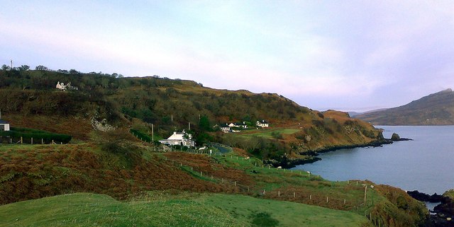
Braes am Bràighe is a rugged and picturesque area located in Inverness-shire, Scotland. It is characterized by rolling hills, moorland, and open grassy fields, offering stunning views of the surrounding landscape. The terrain is dotted with patches of heather, gorse, and scattered trees, creating a diverse and vibrant ecosystem.

The area is popular among outdoor enthusiasts for activities such as hiking, birdwatching, and photography. The expansive moorland provides ample opportunities for exploration and discovery, with numerous walking trails and paths crisscrossing the landscape. Visitors can expect to encounter a variety of wildlife, including birds of prey, deer, and other native species.

Braes am Bràighe is also steeped in history, with traces of ancient settlements and archaeological sites scattered throughout the area. The rugged beauty of the landscape, combined with its rich cultural heritage, makes it a truly unique and captivating destination for visitors looking to immerse themselves in the natural beauty of the Scottish Highlands.

If you have any feedback on the listing, please let us know in the comments section below.

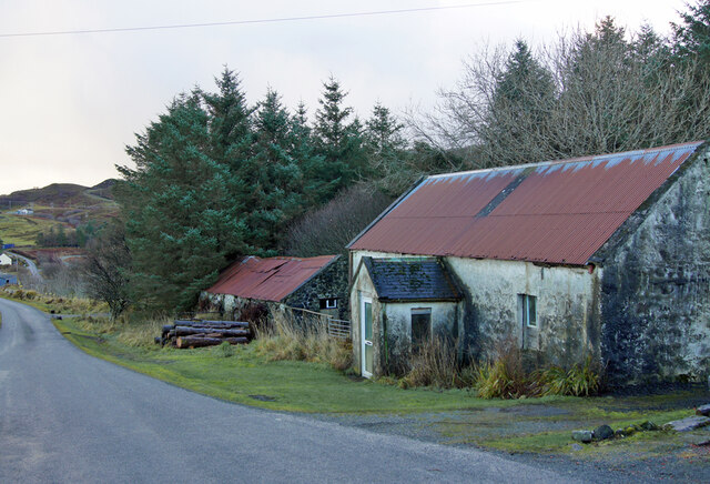
Braes am Bràighe Images

Images are sourced within 2km of 57.357626/-6.1352658 or Grid Reference NG5137. Thanks to Geograph Open Source API. All images are credited.

Southern end of Ben Tianavaig ridge The steep ground gives an excellent view over Tianavaig Bay to the red hills.
Southern end of Ben Tianavaig ridge
The steep ground gives an excellent view over Tianavaig Bay to the red hills.
River  Osglan This river cuts incisively into the rocky ridge and exposes a rather interesting craggy face.
River Osglan
This river cuts incisively into the rocky ridge and exposes a rather interesting craggy face.
Hill Top A view of the heathery top looking north including Loch Fada and ahead Cnoc na h-Airgh Duibhe.
Hill Top
A view of the heathery top looking north including Loch Fada and ahead Cnoc na h-Airgh Duibhe.
Ravine of the Allt Osglan A dramatic cleft in the rocky cliffs carries the Allt Osglan from its source at the northern end of Loch Fada to the plain below. These crags are small by the standards of Skye but the effect is impressive. The stream can be forded nearby.
Ravine of the Allt Osglan
A dramatic cleft in the rocky cliffs carries the Allt Osglan from its source at the northern end of Loch Fada to the plain below. These crags are small by the standards of Skye but the effect is impressive. The stream can be forded nearby.
Bleak moorland above Loch Fada With a distant view of the Black Cuillin.
Bleak moorland above Loch Fada
With a distant view of the Black Cuillin.
Lumpy moorland  It doesn't matter much which way you face here - all you see in every direction is flattish moorland, which quickly becomes boggy in wet weather.
Lumpy moorland
It doesn't matter much which way you face here - all you see in every direction is flattish moorland, which quickly becomes boggy in wet weather.
Odd rock This unusual feature stands all alone amid acres of otherwise largely featureless moorland. 
Another view: <a href="https://www.geograph.org.uk/photo/4089009">NG4935 : Remarkable erratic</a>.
Odd rock
This unusual feature stands all alone amid acres of otherwise largely featureless moorland. Another view: NG4935 : Remarkable erratic.
Crags above Camastianavaig The gorge of the Allt Osglan can be seen breaching the crags on the left.
Crags above Camastianavaig
The gorge of the Allt Osglan can be seen breaching the crags on the left.
Camastianavaig with the slopes of Ben Tianavaig behind Looking across this small village from the nearby shore. Only 5 or 10 minutes from the bustle of Portree this is a beautiful and peaceful place.
Camastianavaig with the slopes of Ben Tianavaig behind
Looking across this small village from the nearby shore. Only 5 or 10 minutes from the bustle of Portree this is a beautiful and peaceful place.
Marker buoy on McMillan's Rock McMillan's Rock is a small low-water rock situate near the narrow channel between Raasay and An Aird on Skye. It can only be seen at extreme low tides, and is marked by this buoy.
Marker buoy on McMillan's Rock
McMillan's Rock is a small low-water rock situate near the narrow channel between Raasay and An Aird on Skye. It can only be seen at extreme low tides, and is marked by this buoy.
Old and new houses in Ollach The ruin of a Braes croft house in the foreground, and a modern red roofed house further back.
Old and new houses in Ollach
The ruin of a Braes croft house in the foreground, and a modern red roofed house further back.
Entering Conordon Power lines cross the Braes road on the edge of the township.
Entering Conordon
Power lines cross the Braes road on the edge of the township.
Moorland north of Conordon With The Storr and Trotternish Ridge in the far distance. 
The grassy bank in the foreground is the overgrown remains of a stone wall which would once have been a township boundary.
The land is grazed by a few wandering sheep and cattle.
Moorland north of Conordon
With The Storr and Trotternish Ridge in the far distance. The grassy bank in the foreground is the overgrown remains of a stone wall which would once have been a township boundary. The land is grazed by a few wandering sheep and cattle.
Barn and house in Achnahanaid The modern large house operates as Bed and Breakfast accommodation.
Barn and house in Achnahanaid
The modern large house operates as Bed and Breakfast accommodation.
Old house and barn Standing at the roadside in Achnahanaid, the large building was almost certainly once a dwelling, though unusually, has no chimneys - which would normally be in the both gable ends.
Old house and barn
Standing at the roadside in Achnahanaid, the large building was almost certainly once a dwelling, though unusually, has no chimneys - which would normally be in the both gable ends.
Braes road in Achnahanaid Looking south east. 
Braes is a district made up of a number of small townships. Ahead are Lower and Upper Ollach.
Braes road in Achnahanaid
Looking south east. Braes is a district made up of a number of small townships. Ahead are Lower and Upper Ollach.
Braesburn Hall, revised Building work is currently underway which will convert the original Braesburn Hall into a domestic dwelling. The new-build will have two en-suite bedrooms, one on the ground floor and one in the roof. The original doorway is to be filled-in, and one arched window becomes rectangular. A new extension on the southern side of the building will provide a sun-lounge. 
Former images of the hall: 
<a href="https://www.geograph.org.uk/photo/677700">NG5136 : Braesburn Hall</a>
<a href="https://www.geograph.org.uk/photo/1454752">NG5136 : Building work at the church hall</a>
Braesburn Hall, revised
Building work is currently underway which will convert the original Braesburn Hall into a domestic dwelling. The new-build will have two en-suite bedrooms, one on the ground floor and one in the roof. The original doorway is to be filled-in, and one arched window becomes rectangular. A new extension on the southern side of the building will provide a sun-lounge. Former images of the hall: NG5136 : Braesburn Hall NG5136 : Building work at the church hall
Braesburn Hall, revised Building work is currently underway which will convert the original Braesburn Hall into a domestic dwelling. The new-build will have two en-suite bedrooms, one on the ground floor and one in the roof, with roof-lights. The original doorway is to be filled-in, and one arched window becomes rectangular. A new extension on the southern side of the building will provide a sun-lounge.
Former images of the hall:
<a href="https://www.geograph.org.uk/photo/677700">NG5136 : Braesburn Hall</a>
<a href="https://www.geograph.org.uk/photo/1454752">NG5136 : Building work at the church hall</a>
Braesburn Hall, revised
Building work is currently underway which will convert the original Braesburn Hall into a domestic dwelling. The new-build will have two en-suite bedrooms, one on the ground floor and one in the roof, with roof-lights. The original doorway is to be filled-in, and one arched window becomes rectangular. A new extension on the southern side of the building will provide a sun-lounge. Former images of the hall: NG5136 : Braesburn Hall NG5136 : Building work at the church hall
Show me another place!

Braes am Bràighe is located at Grid Ref: NG5137 (Lat: 57.357626, Lng: -6.1352658)

Unitary Authority: Highland

Police Authority: Highlands and Islands

What 3 Words

///served.curiosity.correctly. Near Portree, Highland

Related Wikis

Ollach

Ollach (in Scottish Gaelic, An t-Olach) is a remote settlement, made up of Lower Ollach and Upper Ollach, lying on B883 road, south of Portree, Isle of...

Camastianavaig

Camustianavaig (also English spelling: Camustinivaig) is a crofting township on the island of Skye in Scotland. It is located on the shores of the Sound...

Gedintailor

Gedintailor (Scottish Gaelic: Gead an t-Sailleir) is a crofting village, lying on the shores of the Narrows of Raasay on the east coast of the island of...

Ben Tianavaig

Ben Tianavaig is a hill located on the Isle of Skye, near Portree . It is very prominent from Portree dominating the view from the harbour. It is a Marilyn...

Nearby Amenities

Located within 500m of 57.357626,-6.1352658
Passing Place
Lat/Long: 57.3604121/-6.1416055
Passing Place
Lat/Long: 57.3596273/-6.1411659
Passing Place
Lat/Long: 57.3573063/-6.1385124
Bus Stop
Letterbox
Local Ref: AT
Naptan AtcoCode: 6700712953
Naptan Bearing: NW
Naptan CommonName: Letterbox
Naptan Indicator: at
Naptan Landmark: Letterbox
Naptan NaptanCode: 45328397
Naptan Street: B883
Naptan Verified: no
Source: naptan_import
Lat/Long: 57.3567714/-6.1376823
Post Box
Ollach
Collection Times: Mo-Fr 10:00; Sa 10:00
Ref: IV51 9
Lat/Long: 57.3567807/-6.1377089
Barrier: cattle_grid
Lat/Long: 57.3558305/-6.1357627
Power: pole
Lat/Long: 57.3542167/-6.1349523
Power: pole
Lat/Long: 57.3545379/-6.135757
Power: pole
Lat/Long: 57.354964/-6.1369023
Power: pole
Lat/Long: 57.3551586/-6.1374052
Power: pole
Lat/Long: 57.3589622/-6.1430539
Power: pole
Lat/Long: 57.3581245/-6.1420266
Power: pole
Lat/Long: 57.3575473/-6.1412917
Power: pole
Lat/Long: 57.3569331/-6.1405273
Power: pole
Lat/Long: 57.3564412/-6.1399157
Power: pole
Lat/Long: 57.356175/-6.1389233
Power: pole
Lat/Long: 57.3559312/-6.137998
Power: pole
Lat/Long: 57.3557655/-6.1374119
Power: pole
Lat/Long: 57.3552273/-6.1364597
Power: pole
Lat/Long: 57.3547484/-6.1356457
Power: pole
Lat/Long: 57.3554697/-6.1379617
Power: pole
Lat/Long: 57.3563638/-6.1400834
Power: pole
Lat/Long: 57.3574605/-6.1414486
Power: pole
Lat/Long: 57.3585658/-6.1428085
Power: pole
Lat/Long: 57.3573751/-6.1361852
Power: pole
Lat/Long: 57.3570305/-6.1354196
Power: pole
Lat/Long: 57.3569645/-6.1391474
Power: pole
Lat/Long: 57.3573524/-6.1384662
Power: pole
Lat/Long: 57.3573932/-6.1372682
Power: pole
Lat/Long: 57.3574348/-6.1348388
Power: pole
Lat/Long: 57.3578588/-6.1342158
Power: pole
Lat/Long: 57.3543074/-6.1348592
Power: pole
Lat/Long: 57.3535818/-6.1343206
Lower Ollach
Place: locality
Lat/Long: 57.3571245/-6.1376352
Turning Circle
Lat/Long: 57.3589/-6.1402161
Waterway: waterfall
Lat/Long: 57.3606121/-6.1365482
The data included in this document is from www.openstreetmap.org. The data is made available under ODbL.

Have you been to Braes am Bràighe?

Leave your review of Braes am Bràighe below (or comments, questions and feedback).