The Cuddacks

Cliff, Slope in Shetland

Scotland

The Cuddacks

Noss from Lunning Sound
Noss from Lunning Sound Credit: Mike Pennington

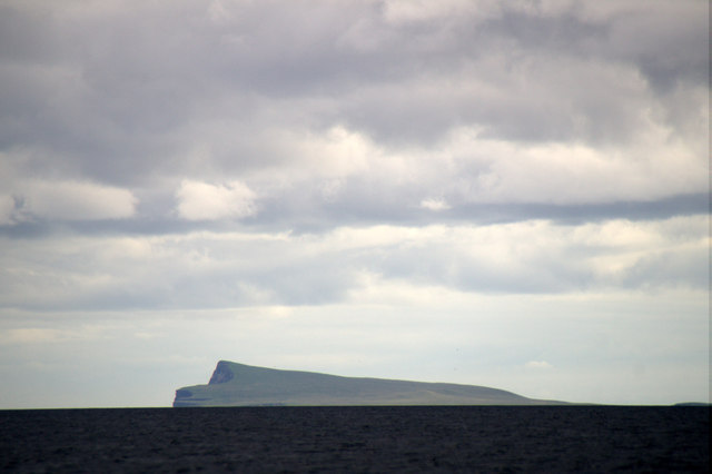
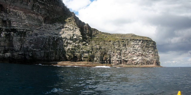
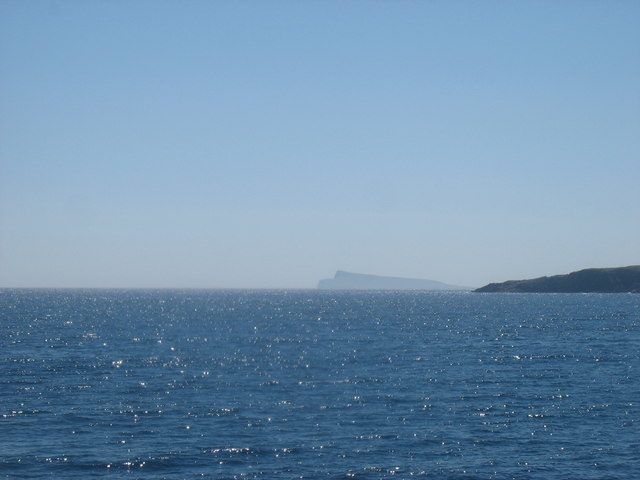
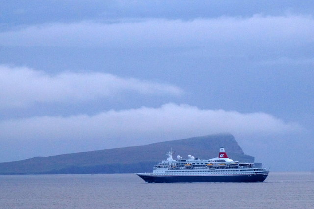
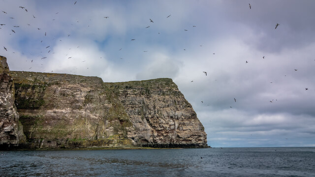
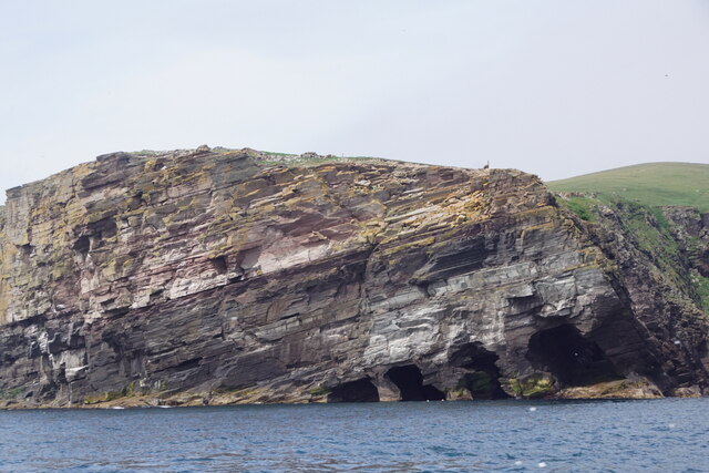
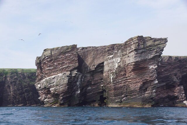
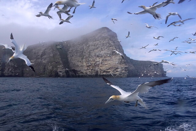
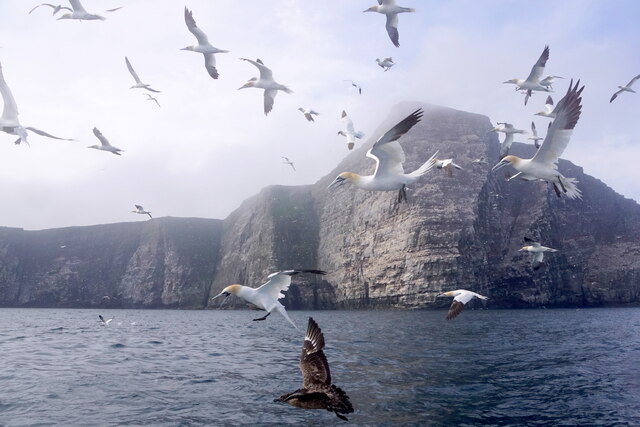
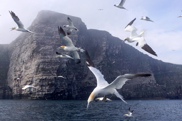
The Cuddacks are a series of cliffs and slopes located in Shetland, an archipelago situated off the north coast of mainland Scotland. These natural formations are renowned for their rugged beauty and provide breathtaking views of the surrounding landscape.

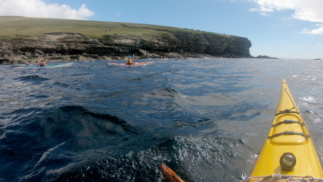
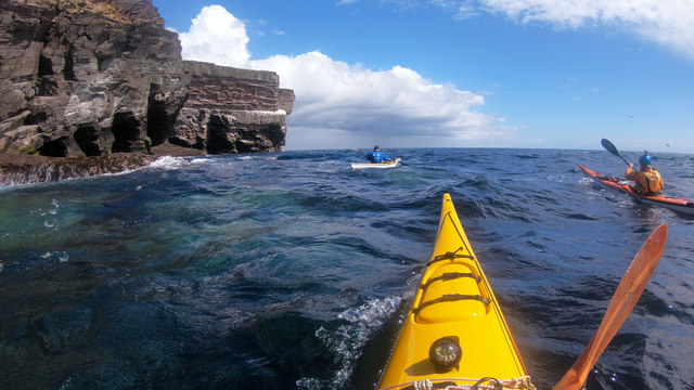
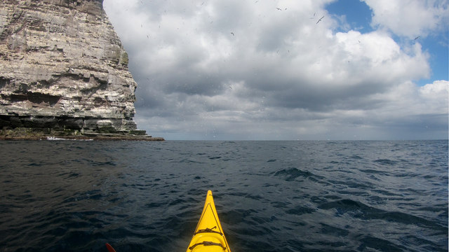
The cliffs of The Cuddacks are characterized by their steep and towering faces, formed from layers of sedimentary rock that have been shaped by centuries of erosion from the harsh North Atlantic Ocean. The rock formations are predominantly composed of sandstone and shale, which create a unique and striking color palette of reds, oranges, and browns.

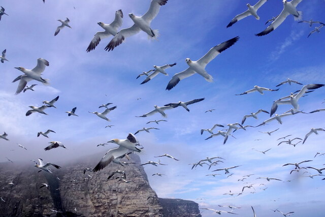
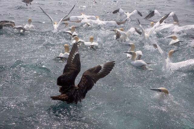
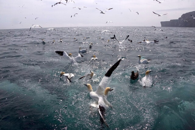
The slopes of The Cuddacks offer a more gentle and gradual descent, providing a contrast to the dramatic cliffs. Covered in lush vegetation, including grasses, shrubs, and wildflowers, these slopes are home to various species of birds and small mammals.

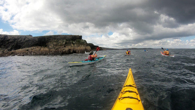
The Cuddacks are a popular destination for outdoor enthusiasts and nature lovers, offering opportunities for hiking, birdwatching, and photography. Visitors can explore the cliffs and slopes through a network of well-maintained trails that wind their way along the coastline, providing stunning views of the surrounding sea and nearby islands.

Due to their exposed location, The Cuddacks are subject to strong winds and unpredictable weather conditions. It is important for visitors to come prepared with appropriate clothing and equipment to ensure a safe and enjoyable experience.

Overall, The Cuddacks in Shetland are a must-visit for those seeking to immerse themselves in the wild and untamed beauty of Scotland's coastal landscapes.

If you have any feedback on the listing, please let us know in the comments section below.

The Cuddacks Images

Images are sourced within 2km of 60.138631/-1.0078971 or Grid Reference HU5539. Thanks to Geograph Open Source API. All images are credited.

Noss from Lunning Sound
Gannets on The Rump, Noss The prime nesting sites in any gannetry are the flatter ones in positions still inaccessible to land predators from above. Easier, safer landings are one obvious benefit (a couple of days after this photo was taken, we came across a Gannet which had got its approach wrong and was hanging, dead, by one wing from a crack in the cliff - gusty downdraughts can hit at any time so misjudgements aren't the only cause of accidents).

Beyond The Rump, the cliffs return to the vertical once more at Point of Heogatoug, beyond which the coast gets lower, and the bird nesting paradise soon comes to an end. It's an exciting couple of kilometres of paddling up to this point.
Gannets on The Rump, Noss
The prime nesting sites in any gannetry are the flatter ones in positions still inaccessible to land predators from above. Easier, safer landings are one obvious benefit (a couple of days after this photo was taken, we came across a Gannet which had got its approach wrong and was hanging, dead, by one wing from a crack in the cliff - gusty downdraughts can hit at any time so misjudgements aren't the only cause of accidents). Beyond The Rump, the cliffs return to the vertical once more at Point of Heogatoug, beyond which the coast gets lower, and the bird nesting paradise soon comes to an end. It's an exciting couple of kilometres of paddling up to this point.
Paddling past Scarfi Skerries Paddling anticlockwise round the island of Noss, Scarfi Skerries and East Punds Geo, just beyond, are almost the last rock-hopping opportunities. After Point of Pundsgeo, the coast is a little more subdued, and our route would take us further out on our way back towards Bressay, whose easternmost point lies on the Loder Head peninsula at Rules Ness, pretty much directly in front of the most distant paddler in the photo. There are far fewer birds here than on the east coast, but inland, the island is still inhabited by heavy tripod-toting chaps in camouflage jackets. They seem to move more slowly than sea kayakers, though that might simply mean that they stop more often to take photos.
Paddling past Scarfi Skerries
Paddling anticlockwise round the island of Noss, Scarfi Skerries and East Punds Geo, just beyond, are almost the last rock-hopping opportunities. After Point of Pundsgeo, the coast is a little more subdued, and our route would take us further out on our way back towards Bressay, whose easternmost point lies on the Loder Head peninsula at Rules Ness, pretty much directly in front of the most distant paddler in the photo. There are far fewer birds here than on the east coast, but inland, the island is still inhabited by heavy tripod-toting chaps in camouflage jackets. They seem to move more slowly than sea kayakers, though that might simply mean that they stop more often to take photos.
Noss Head Seen from the Whalsay ferry en route between Symbister and Laxo.

I do not normally submit this type of 'long distance view' with no foreground, but this one seemed interesting enough to add to the site.
Noss Head
Seen from the Whalsay ferry en route between Symbister and Laxo. I do not normally submit this type of 'long distance view' with no foreground, but this one seemed interesting enough to add to the site.
Noss from the SW, with a cruise ship on its way to Lerwick The ship is the MV Boudicca, a cruise ship owned and operated by Fred Olsen Cruise Lines, which was built in 1973 by Wärtsilä Helsinki Shipyard in Finland as Royal Viking Sky.
Noss from the SW, with a cruise ship on its way to Lerwick
The ship is the MV Boudicca, a cruise ship owned and operated by Fred Olsen Cruise Lines, which was built in 1973 by Wärtsilä Helsinki Shipyard in Finland as Royal Viking Sky.
Paddling past the Point and Geos of Hovie Although we'd picked the sheltered side of Shetland after a day of high wind on our crossing from mainland Scotland, there was still some swell setting in from the east. Across that, wind waves from the southwest made for interesting conditions round the south side of Noss, with confused water particularly around the headland ahead of us. It still seemed less work than the people on the slopes of Hill of Setter who were trekking across above us with a big camera and heavy-looking tripod. It's a bit of a toss-up as to who would get the closer views of the Gannets and Razorbills - we would certainly feel safer down here than teetering on the cliff edge in the gusty wind, and find Razorbills rafting on the surface, but then they'd probably get better photos than those below in the waves !
Paddling past the Point and Geos of Hovie
Although we'd picked the sheltered side of Shetland after a day of high wind on our crossing from mainland Scotland, there was still some swell setting in from the east. Across that, wind waves from the southwest made for interesting conditions round the south side of Noss, with confused water particularly around the headland ahead of us. It still seemed less work than the people on the slopes of Hill of Setter who were trekking across above us with a big camera and heavy-looking tripod. It's a bit of a toss-up as to who would get the closer views of the Gannets and Razorbills - we would certainly feel safer down here than teetering on the cliff edge in the gusty wind, and find Razorbills rafting on the surface, but then they'd probably get better photos than those below in the waves !
Confused water off Feadda Ness The rock over which the wave is just breaking (and water from the previous wave pouring off) is the southernmost point of the island of Noss at this state of the tide (lowish - early in the flood, near neaps). Turning this headland from the southwest coast starts to open up views of progressively more interesting rock scenery as well as increasing amounts of bird life. There are small caves just here, and a Geo between the first and second sections of cliff in this photo. I paddled into more sheltered water inside, where bigger caves awaited exploration, but in the rather confused water (southwesterly windwaves cutting across easterly swell) no-one seemed to want to join me and it's not a place to play without a bit of backup... The rock is a mix of sandstones and conglomerates of Devonian (Old Red Sandstone) age where layers of varying hardness have eroded into the many ledges which make the place such an attractive place for seabirds.
Confused water off Feadda Ness
The rock over which the wave is just breaking (and water from the previous wave pouring off) is the southernmost point of the island of Noss at this state of the tide (lowish - early in the flood, near neaps). Turning this headland from the southwest coast starts to open up views of progressively more interesting rock scenery as well as increasing amounts of bird life. There are small caves just here, and a Geo between the first and second sections of cliff in this photo. I paddled into more sheltered water inside, where bigger caves awaited exploration, but in the rather confused water (southwesterly windwaves cutting across easterly swell) no-one seemed to want to join me and it's not a place to play without a bit of backup... The rock is a mix of sandstones and conglomerates of Devonian (Old Red Sandstone) age where layers of varying hardness have eroded into the many ledges which make the place such an attractive place for seabirds.
Guillemots rafted below Cradle Holm A large flock of Guillemots were rafted up just below the cliffs as we turned the southern tip of Noss, so we aimed away from the coast a bit to give them some space. However, they suddenly chose to head out to sea directly in front of our group - they do take a long time bouncing off the wave tops to get airborne so we were treated to a closer view than we'd have ventured to get.

The nearest cliff face, with the cave entrance, is Cradle Holm, an island at all but low tide (and pretty inaccessible from Noss even then, as there is a deep rocky cleft the same height as the cliffs). Beyond this is Charlie's Holm, with rock of a similar colour, whilst in the distance, looking much whiter, is Noup of Noss, surrounded by wheeling Gannets.
Guillemots rafted below Cradle Holm
A large flock of Guillemots were rafted up just below the cliffs as we turned the southern tip of Noss, so we aimed away from the coast a bit to give them some space. However, they suddenly chose to head out to sea directly in front of our group - they do take a long time bouncing off the wave tops to get airborne so we were treated to a closer view than we'd have ventured to get. The nearest cliff face, with the cave entrance, is Cradle Holm, an island at all but low tide (and pretty inaccessible from Noss even then, as there is a deep rocky cleft the same height as the cliffs). Beyond this is Charlie's Holm, with rock of a similar colour, whilst in the distance, looking much whiter, is Noup of Noss, surrounded by wheeling Gannets.
Gannets fill the air at Noup of Noss Whilst the southern tip of Noss is home to auks, Noss Head is the summer residence of a large number of Gannets. Very few were fishing in the immediate vicinity, but both the cliffs and the air were filled with noisy bird life, especially around the headland and in Rumble Wick, the bay to its south. The Devonian Old Red Sandstone hardly dips here, and the rock has eroded into ledges and pockets bigger than those further south where the rock beds dip more, suiting the Gannets better than the smaller species who prefer Holm of Noss.
Gannets fill the air at Noup of Noss
Whilst the southern tip of Noss is home to auks, Noss Head is the summer residence of a large number of Gannets. Very few were fishing in the immediate vicinity, but both the cliffs and the air were filled with noisy bird life, especially around the headland and in Rumble Wick, the bay to its south. The Devonian Old Red Sandstone hardly dips here, and the rock has eroded into ledges and pockets bigger than those further south where the rock beds dip more, suiting the Gannets better than the smaller species who prefer Holm of Noss.
Noss Head/Noup of Noss
Fedda Ness, Noss, from the sea
Cradle Holm, Noss, from the sea Although labelled Holm of Noss on the OS maps this is known as Cradle Holm locally.
Cradle Holm, Noss, from the sea
Although labelled Holm of Noss on the OS maps this is known as Cradle Holm locally.
Gannets off the Noup of Noss
Great Skua and Gannets off the Noup of Noss
Gannets off the Noup of Noss
Great Skua and Gannets on the sea off Noss
Gannets on the sea off Noss
Show me another place!

The Cuddacks is located at Grid Ref: HU5539 (Lat: 60.138631, Lng: -1.0078971)

Unitary Authority: Shetland Islands

Police Authority: Highlands and Islands

What 3 Words

///secure.incensed.tinsel. Near Lerwick, Shetland Islands

Related Wikis

Holm of Noss

The Holm of Noss or Cradle Holm is an uninhabited islet of the Shetland Islands. It is about 48m at its highest point. == Geography and geology == It is...

Isle of Noss

The Isle of Noss or Noss (Scots: Noss) is a small, previously inhabited island in Shetland, Scotland. Noss is separated from the island of Bressay by the...

Broch of Cullingsburgh

The Broch of Cullingsburgh is an Iron Age broch located in the Shetland islands. == Location == Located on Bressay, off the east coast of mainland Shetland...

Voe of Cullingsburgh

Voe of Cullingsburgh is a large sea loch off the Shetland island of Bressay, voe meaning "sea inlet" in Shetland dialect. The local spelling of the name...

Nearby Amenities

Located within 500m of 60.138631,-1.0078971
Noss Head
Corbett: no
Ele: 181
Graham: no
Marilyn: yes
Munro: no
Natural: peak
Prominence: 181
Lat/Long: 60.1401383/-1.0056785
The data included in this document is from www.openstreetmap.org. The data is made available under ODbL.

Have you been to The Cuddacks?

Leave your review of The Cuddacks below (or comments, questions and feedback).