Wildrig

Cliff, Slope in Shetland

Scotland

Wildrig

Spiggie and Loch of Spiggie
Spiggie and Loch of Spiggie Credit: Mike Pennington

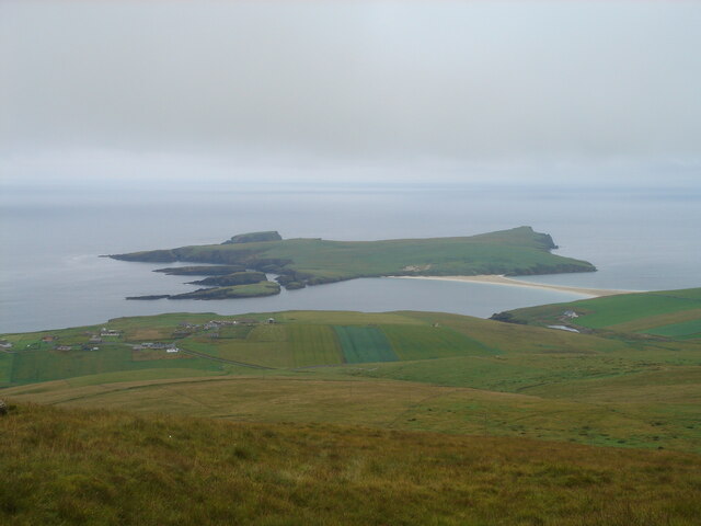
Wildrig is a picturesque cliff and slope located in the rural region of Shetland, Scotland. This natural wonder is renowned for its stunning landscapes and breathtaking views, attracting visitors from all over the world.

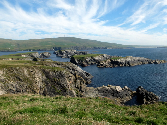
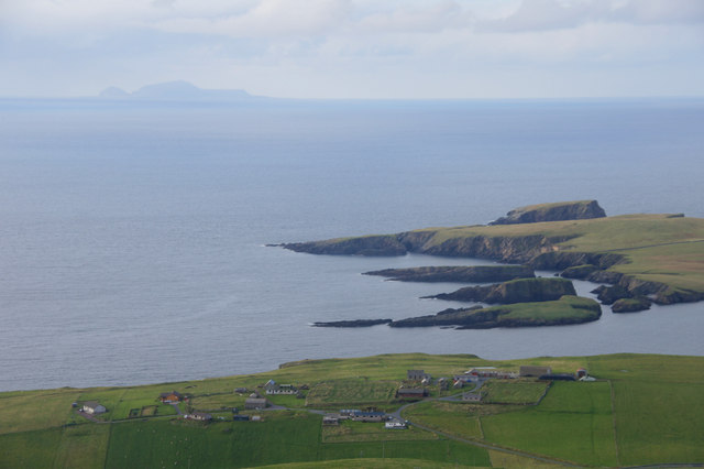
Situated on the western coast of Shetland, Wildrig offers a dramatic setting with its steep cliffs and rugged terrain. The cliff stands tall, rising several meters above sea level, providing visitors with a bird's-eye view of the surrounding area. The slope, on the other hand, gently descends towards the shoreline, creating a harmonious blend of steepness and tranquility.

The cliffs at Wildrig are composed of layers of sedimentary rocks, showcasing a rich geological history. Visitors can observe the different rock formations, including sandstone and shale, which have been shaped by millions of years of natural forces such as erosion and tectonic movements.

The area surrounding Wildrig is abundant in wildlife, making it an ideal spot for nature enthusiasts. Seabirds, including puffins, guillemots, and fulmars, can be seen nesting on the cliff edges, providing a captivating sight during the breeding season. The surrounding waters are also home to various marine species, including seals and dolphins, which can often be spotted swimming along the coast.

Wildrig is accessible via a footpath that leads visitors to the cliff's edge, allowing for a safe and enjoyable experience. The site is often visited by hikers, photographers, and nature lovers seeking to immerse themselves in the raw beauty of Shetland's landscape.

In conclusion, Wildrig in Shetland offers a remarkable combination of rugged cliffs, gentle slopes, and diverse wildlife. Its geological features, stunning views, and abundant wildlife make it a must-visit destination for those exploring the natural wonders of Scotland.

If you have any feedback on the listing, please let us know in the comments section below.

Wildrig Images

Images are sourced within 2km of 59.948775/-1.3428643 or Grid Reference HU3618. Thanks to Geograph Open Source API. All images are credited.

Spiggie and Loch of Spiggie
Sand dunes at Sands of Scousburgh
Colsay from the air
Colsay from the air
View from the slopes of the Ward of Scousburgh With a good view of St Ninian's Isle and tombolo <a href="https://www.geograph.org.uk/gridref/HU3620">HU3620</a>.
View from the slopes of the Ward of Scousburgh
With a good view of St Ninian's Isle and tombolo HU3620.
View from the slopes of the Ward of Scousburgh A good view of Scousburgh Bay <a href="https://www.geograph.org.uk/gridref/HU3718">HU3718</a>, Northern Ness and Muckle Sound <a href="https://www.geograph.org.uk/gridref/HU3618">HU3618</a>.
View from the slopes of the Ward of Scousburgh
A good view of Scousburgh Bay HU3718, Northern Ness and Muckle Sound HU3618.
The slopes of Ward of Scousburgh From the minor road which serves various transmission masts and a former NATO station. Below is St Ninian's Isle and the tombolo which connects it to Shetland Mainland.
The slopes of Ward of Scousburgh
From the minor road which serves various transmission masts and a former NATO station. Below is St Ninian's Isle and the tombolo which connects it to Shetland Mainland.
St Ninian's Bay I am standing at the mainland end of the tombolo leading to St Ninian's Isle and looking south down St Ninian's Bay towards Inns Holm with Colsay off to the right. Northern Ness, Fora Ness and Noss Hill can be gilmpsed in the clouded distance.
St Ninian's Bay
I am standing at the mainland end of the tombolo leading to St Ninian's Isle and looking south down St Ninian's Bay towards Inns Holm with Colsay off to the right. Northern Ness, Fora Ness and Noss Hill can be gilmpsed in the clouded distance.
High Herbi Clett from St. Ninian's Isle In the distance to the right of the picture you can see the isle of Colsay, and behind it the distinctive Fitful Head.
High Herbi Clett from St. Ninian's Isle
In the distance to the right of the picture you can see the isle of Colsay, and behind it the distinctive Fitful Head.
Sea Stacks south of St Ninian's Isle
St Ninian's Isle The small island on the left is Inns Holm.
St Ninian's Isle
The small island on the left is Inns Holm.
St Ninian's Bay
St Ninian's Bay
St Ninian's Isle Wonderful coastal scenery of cliffs, skerries and the islet of Inns Holm at the southern tip of St Ninian's Isle.
St Ninian's Isle
Wonderful coastal scenery of cliffs, skerries and the islet of Inns Holm at the southern tip of St Ninian's Isle.
Islet off St Ninian's Isle One of several rocky islets by the spectacular coastline on the southern end of St Ninian's Isle.
Islet off St Ninian's Isle
One of several rocky islets by the spectacular coastline on the southern end of St Ninian's Isle.
St. Ninian’s Isle: towards Inns Holm Looking along the southeastern part of St. Ninian's Isle, with Inns Holm off the end of the island. Colsay is to the right, in the mist.
St. Ninian’s Isle: towards Inns Holm
Looking along the southeastern part of St. Ninian's Isle, with Inns Holm off the end of the island. Colsay is to the right, in the mist.
Hevda and Inns Holm from St Ninian's Isle Taken from the high ground above the tombolo looking down the length of the Hevda promontory to Inns Holm, a separate islet just off the south coast of St Ninian's Isle.
Hevda and Inns Holm from St Ninian's Isle
Taken from the high ground above the tombolo looking down the length of the Hevda promontory to Inns Holm, a separate islet just off the south coast of St Ninian's Isle.
South coastline of St Ninian's Isle Spectacular.
South coastline of St Ninian's Isle
Spectacular.
South side of St Ninian's Isle from Ward of Scousburgh Inns Holm at the SE corner of St Ninain's Isle and Sweyn Holm at the SW corner; Foula in the distance.
South side of St Ninian's Isle from Ward of Scousburgh
Inns Holm at the SE corner of St Ninain's Isle and Sweyn Holm at the SW corner; Foula in the distance.
Bay of Scousburgh at dusk
Show me another place!

Wildrig is located at Grid Ref: HU3618 (Lat: 59.948775, Lng: -1.3428643)

Unitary Authority: Shetland Islands

Police Authority: Highlands and Islands

What 3 Words

///includes.shortens.joke. Near Sandwick, Shetland Islands

Related Wikis

Colsay

Colsay is an uninhabited island off the South West coast of Mainland, Shetland. Fora Ness lies to the south, across the Muckle Sound. The highest elevation...

Scousburgh

Scousburgh is a small community in the parish of Dunrossness, in the South Mainland of Shetland, Scotland, overlooking the picturesque Scousburgh Sand...

Lochs of Spiggie and Brow

The Lochs of Spiggie and Brow are located west of Boddam in the parish of Dunrossness, in the South Mainland of Shetland, Scotland, about 6 km north of...

Dunrossness

Dunrossness, (Old Norse: Dynrastarnes meaning "headland of the loud tide-race", referring to the noise of Sumburgh Roost) is the southernmost parish of...

St Ninian's Isle

St Ninian's Isle is a small tied island connected by the largest tombolo in the UK to the south-western coast of the Mainland, Shetland, in Scotland. It...

Bigton

Bigton is a small settlement on South Mainland, Shetland, UK. Bigton is within the civil parish of Dunrossness.Bigton lies on the Atlantic coast of the...

Clumlie Broch

Clumlie Broch is an Iron Age broch located on Mainland, Shetland, in Scotland (grid reference HU40451811). == Location == Clumlie Broch is located in Dunrossness...

Boddam, Shetland

Boddam is a village on the island of Mainland, in Shetland, Scotland. Boddam is an area of Dunrossness in the South Mainland of Shetland. Although Boddam...

Have you been to Wildrig?

Leave your review of Wildrig below (or comments, questions and feedback).