Piercefield Cliffs

Cliff, Slope in Monmouthshire

Wales

Piercefield Cliffs

High stone wall, Tidenham, Gloucestershire The northern perimeter wall of St Mary & St Peter's churchyard in the Church of England Diocese of Gloucester.
High stone wall, Tidenham, Gloucestershire Credit: Jaggery

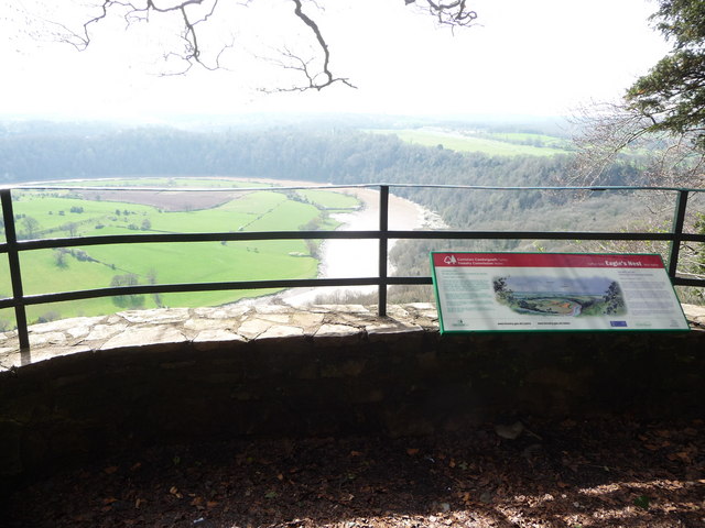
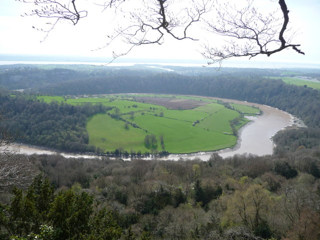
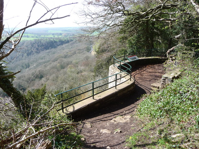
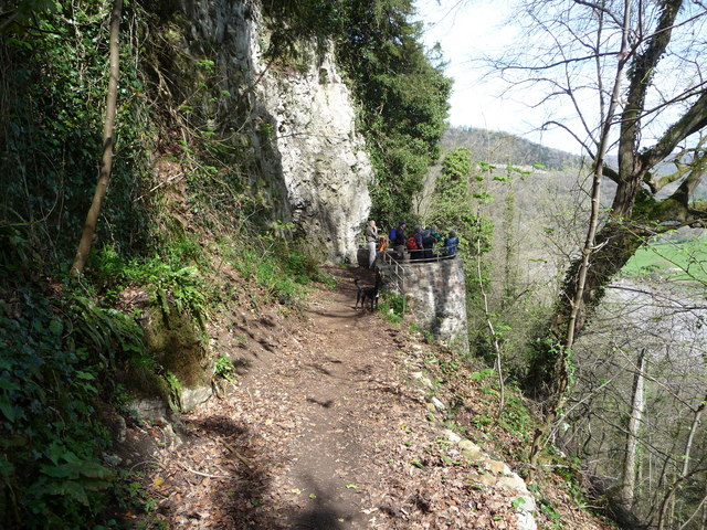
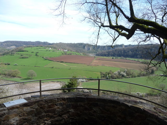
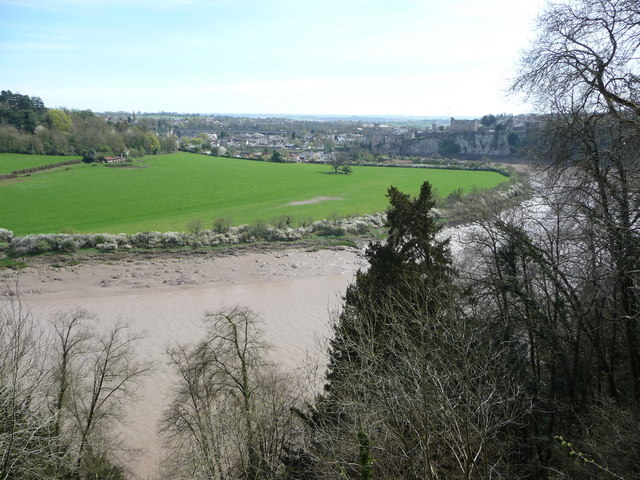
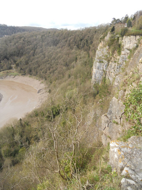
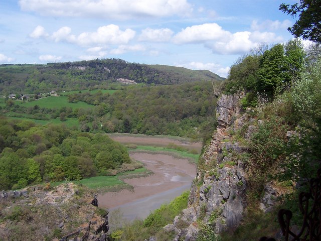
Piercefield Cliffs, located in Monmouthshire, Wales, is a striking geological feature that spans approximately six miles along the east bank of the River Wye. This prominent cliff and slope formation offers breathtaking panoramic views of the surrounding landscape and the river below.

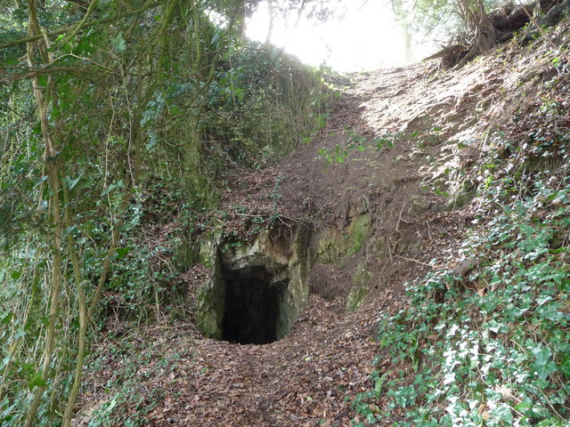
The cliffs themselves are made up of layers of sedimentary rock, primarily sandstone, which has been shaped by millions of years of erosion. The exposed rock faces showcase the unique geological history of the area, with distinct layers revealing different periods of deposition and environmental changes.

The cliff edges provide a habitat for a diverse range of plant and animal species. The rocky ledges and crevices offer nesting sites for birds such as peregrine falcons and ravens, while the surrounding woodland supports a variety of woodland birds and mammals. Rare plant species, including the small-leaved lime tree, can also be found in the area.

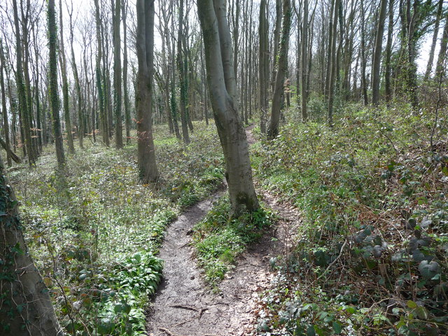
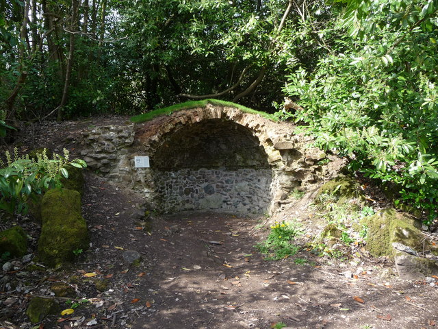
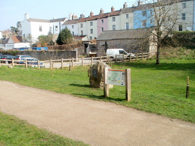
Visitors to Piercefield Cliffs can explore the area along a well-maintained footpath that runs parallel to the river. Along the way, they can enjoy stunning views of the river and the Wye Valley, with its rolling hills and dense forests. The cliffs also offer vantage points to observe the abundant wildlife and the occasional glimpse of canoeists and kayakers navigating the river.

Piercefield Cliffs is a designated Site of Special Scientific Interest, recognized for its geological and ecological importance. Its natural beauty and rich biodiversity make it a popular destination for nature lovers, hikers, and those seeking a tranquil escape in the heart of Monmouthshire.

If you have any feedback on the listing, please let us know in the comments section below.

Piercefield Cliffs Images

Images are sourced within 2km of 51.661568/-2.6718891 or Grid Reference ST5396. Thanks to Geograph Open Source API. All images are credited.

High stone wall, Tidenham, Gloucestershire The northern perimeter wall of St Mary & St Peter's churchyard in the Church of England Diocese of Gloucester.
High stone wall, Tidenham, Gloucestershire
The northern perimeter wall of St Mary & St Peter's churchyard in the Church of England Diocese of Gloucester.
NW side of the church, Tidenham, Gloucestershire St Mary & St Peter in the Church of England Diocese of Gloucester has 13th and 14th century origins. 
It was extensively restored in 1858. Grade II (Star) Listed in 1954.
NW side of the church, Tidenham, Gloucestershire
St Mary & St Peter in the Church of England Diocese of Gloucester has 13th and 14th century origins. It was extensively restored in 1858. Grade II (Star) Listed in 1954.
Churchyard exit gates, Tidenham, Gloucestershire At a minor exit from St Mary & St Peter's churchyard in the Church of England Diocese of Gloucester.
Churchyard exit gates, Tidenham, Gloucestershire
At a minor exit from St Mary & St Peter's churchyard in the Church of England Diocese of Gloucester.
Track between wall and hedge, Tidenham, Gloucestershire Viewed from these <a title="https://www.geograph.org.uk/photo/7691725" href="https://www.geograph.org.uk/photo/7691725">Link</a> churchyard exit gates.
Track between wall and hedge, Tidenham, Gloucestershire
Viewed from these Link churchyard exit gates.
Part of the Wye Valley Walk in Wyndcliff wood If there is one criticism of the WVW in this section it is that you don't get to see much of the River Wye, but, you do get to see varied woodlands, and an  appreciation of the valley's history, geology, ecology and industrial heritage.
Part of the Wye Valley Walk in Wyndcliff wood
If there is one criticism of the WVW in this section it is that you don't get to see much of the River Wye, but, you do get to see varied woodlands, and an appreciation of the valley's history, geology, ecology and industrial heritage.
The Eagle's Nest viewpoint on the Wynd Cliff The information board fitted by the Forestry Commission tells of how this viewpoint got its name and what can be viewed. A beautiful spot that I never tire of revisiting.
The Eagle's Nest viewpoint on the Wynd Cliff
The information board fitted by the Forestry Commission tells of how this viewpoint got its name and what can be viewed. A beautiful spot that I never tire of revisiting.
The Lancaut peninsula from the Eagle's Nest The huge curve in the Wye is a well-known view with Chepstow and the Severn Bridges beyond.
The Lancaut peninsula from the Eagle's Nest
The huge curve in the Wye is a well-known view with Chepstow and the Severn Bridges beyond.
The Eagle's Nest An excellent spot for a rest, a brew and some lunch.
The Eagle's Nest
An excellent spot for a rest, a brew and some lunch.
A group of walkers at the Giant's Cave in the Wye Valley This group of retired walkers were enjoying the viewing platform just outside the Giant's Cave as I approached and was spotted by their little dog. They were a mix of local and not so local fellers who were enjoying their firm friendships, relaxed banter, outdoor exercise and the good weather. Not a bad way to spend some of your retirement.
A group of walkers at the Giant's Cave in the Wye Valley
This group of retired walkers were enjoying the viewing platform just outside the Giant's Cave as I approached and was spotted by their little dog. They were a mix of local and not so local fellers who were enjoying their firm friendships, relaxed banter, outdoor exercise and the good weather. Not a bad way to spend some of your retirement.
The northern entrance to the Giant's Cave on the Wye Valley Walk Yes, you are expected to enter or exit through this aperture. It's easier and more fun than it looks. One of many interesting features on this section of the WVW.
The northern entrance to the Giant's Cave on the Wye Valley Walk
Yes, you are expected to enter or exit through this aperture. It's easier and more fun than it looks. One of many interesting features on this section of the WVW.
View from the Giant's Cave viewing platform The view across the graceful curve of the River Wye onto the Lancaut peninsula and above that up to Wintour's Leap and the great cliffs near Woodcroft.
View from the Giant's Cave viewing platform
The view across the graceful curve of the River Wye onto the Lancaut peninsula and above that up to Wintour's Leap and the great cliffs near Woodcroft.
The Grotto in Piercefield Woods This feature, along with several others on a similar 'Romantic' theme, was installed in Piercefield Park and woods and comprised part of a tour through this area between around 1760 and maybe the 1820's. Gentry came from various parts of the country and toured the Wye Valley inspecting folly's, caves, walks, viewpoints and landscapes and often recording their opinions and thoughts in journals and publications. Originally this grotto was of course larger, more complete and lined inside with 'glittering crystalline minerals, glass fragments and iron and copper slag'. This would have created an elaborate decorated effect intended to mimic naturally occurring outcrops. I'm glad to see the Piercefield Walks features receiving some improvement.
The Grotto in Piercefield Woods
This feature, along with several others on a similar 'Romantic' theme, was installed in Piercefield Park and woods and comprised part of a tour through this area between around 1760 and maybe the 1820's. Gentry came from various parts of the country and toured the Wye Valley inspecting folly's, caves, walks, viewpoints and landscapes and often recording their opinions and thoughts in journals and publications. Originally this grotto was of course larger, more complete and lined inside with 'glittering crystalline minerals, glass fragments and iron and copper slag'. This would have created an elaborate decorated effect intended to mimic naturally occurring outcrops. I'm glad to see the Piercefield Walks features receiving some improvement.
View from The Alcove in Alcove Wood This is another welcome viewpoint on the Wye Valley Walk, just outside Chepstow and offers an excellent perspective on the castle, River Wye and the Lancaut peninsula.
View from The Alcove in Alcove Wood
This is another welcome viewpoint on the Wye Valley Walk, just outside Chepstow and offers an excellent perspective on the castle, River Wye and the Lancaut peninsula.
Chepstow Castle entrance A very impressive statement of Norman power and a great feature in Chepstow town.
Chepstow Castle entrance
A very impressive statement of Norman power and a great feature in Chepstow town.
Reaching the Winning Post, Chepstow Racecourse
General view, Chepstow Racecourse
Cliff by the River Wye
Southern end of Wye Valley Walk, Chepstow The large stone <a title="https://www.geograph.org.uk/photo/2365731" href="https://www.geograph.org.uk/photo/2365731">Link</a> next to an information board in Castle Dell marks the southern end of the 136 mile Wye Valley Walk.
Southern end of Wye Valley Walk, Chepstow
The large stone Link next to an information board in Castle Dell marks the southern end of the 136 mile Wye Valley Walk.
Show me another place!

Piercefield Cliffs is located at Grid Ref: ST5396 (Lat: 51.661568, Lng: -2.6718891)

Unitary Authority: Monmouthshire

Police Authority: Gwent

What 3 Words

///remodel.finer.strapping. Near Chepstow, Monmouthshire

Related Wikis

Wintour's Leap

Wintour's Leap is a noted rock climbing location and viewpoint. It is located near the village of Woodcroft in Gloucestershire, on the English side of...

Lancaut

Lancaut (Welsh: Llan Cewydd) is a deserted village and former civil parish, now in the parish of Tidenham, in the Forest of Dean district, in Gloucestershire...

Lower Wye Gorge SSSI

Lower Wye Gorge (grid reference ST548983, ST537967) is a 65-hectare (160-acre) biological and geological Site of Special Scientific Interest in Gloucestershire...

Woodcroft, Gloucestershire

Woodcroft is a small village in the Forest of Dean district of Gloucestershire, England. It is located on the eastern bank of the River Wye, opposite...

Nearby Amenities

Located within 500m of 51.661568,-2.6718891
Source: PGS
Lat/Long: 51.6602796/-2.6787843
Source: PGS
Lat/Long: 51.6603653/-2.6778479
Source: PGS
Lat/Long: 51.6605874/-2.676763
Source: PGS
Lat/Long: 51.6607998/-2.6760366
Source: PGS
Lat/Long: 51.6610198/-2.6754296
Source: PGS
Lat/Long: 51.6613093/-2.6747956
Source: PGS
Lat/Long: 51.6615015/-2.6744375
Source: PGS
Lat/Long: 51.6617659/-2.6739818
Source: PGS
Lat/Long: 51.662528/-2.672976
Source: PGS
Lat/Long: 51.6621647/-2.6720817
Source: PGS
Lat/Long: 51.6612707/-2.6728915
Source: PGS
Lat/Long: 51.660923/-2.6737166
Source: PGS
Lat/Long: 51.6607148/-2.6739059
Source: PGS
Lat/Long: 51.660481/-2.674226
Source: PGS
Lat/Long: 51.6601/-2.6751444
Source: PGS
Lat/Long: 51.659788/-2.6759144
Source: PGS
Lat/Long: 51.659634/-2.6767454
Source: PGS
Lat/Long: 51.6595225/-2.6774089
Source: PGS
Lat/Long: 51.657316/-2.6706414
Source: PGS
Lat/Long: 51.6577827/-2.6702747
Source: PGS
Lat/Long: 51.6582199/-2.6697434
Source: PGS
Lat/Long: 51.6590177/-2.6689414
Source: PGS
Lat/Long: 51.6601027/-2.6682163
Source: PGS
Lat/Long: 51.6612512/-2.6674487
Source: PGS
Lat/Long: 51.6619895/-2.6670882
Source: PGS
Lat/Long: 51.6623879/-2.6669431
Source: PGS
Lat/Long: 51.6627248/-2.6667768
Source: PGS
Lat/Long: 51.6628944/-2.667192
Source: PGS
Lat/Long: 51.6633274/-2.6670156
Source: PGS
Lat/Long: 51.6634095/-2.6674123
Source: PGS
Lat/Long: 51.6636755/-2.6679838
Source: PGS
Lat/Long: 51.6638891/-2.6684347
Source: PGS
Lat/Long: 51.6643493/-2.6677124
Source: PGS
Lat/Long: 51.6639552/-2.6666022
Source: PGS
Lat/Long: 51.6644744/-2.6669665
Source: PGS
Lat/Long: 51.6646258/-2.6673935
Source: PGS
Lat/Long: 51.664628/-2.6678607
Source: PGS
Lat/Long: 51.6645406/-2.6683618
Source: PGS
Lat/Long: 51.664378/-2.668843
Source: PGS
Lat/Long: 51.663975/-2.6694548
Source: PGS
Lat/Long: 51.663672/-2.6701607
Source: PGS
Lat/Long: 51.66329/-2.670705
Source: PGS
Lat/Long: 51.662779/-2.67112
Source: PGS
Lat/Long: 51.6632867/-2.6721667
Source: PGS
Lat/Long: 51.6636555/-2.6718744
Source: PGS
Lat/Long: 51.664022/-2.6715101
Source: PGS
Lat/Long: 51.6645228/-2.6710877
Source: PGS
Lat/Long: 51.6648584/-2.6707476
Source: PGS
Lat/Long: 51.6653753/-2.6696184
Source: PGS
Lat/Long: 51.6655679/-2.6689167
Source: PGS
Lat/Long: 51.6630072/-2.6650538
Source: PGS
Lat/Long: 51.661994/-2.665357
Source: PGS
Lat/Long: 51.66097/-2.665777
Source: PGS
Lat/Long: 51.660459/-2.666193
Source: PGS
Lat/Long: 51.659691/-2.66661
Source: PGS
Lat/Long: 51.658667/-2.666823
Source: PGS
Lat/Long: 51.6610783/-2.6734543
Source: PGS
Lat/Long: 51.6615025/-2.6725743
Source: PGS
Lat/Long: 51.6578216/-2.6678819
Bench
Tourism: viewpoint
Lat/Long: 51.6658893/-2.6715701
The Grotto
Note: man-made cave-like structure
Tourism: attraction
Lat/Long: 51.6583091/-2.6766898
Source: PGS
Lat/Long: 51.6655744/-2.6694105
Source: PGS
Lat/Long: 51.6649813/-2.6704791
Entrance: yes
Lat/Long: 51.6651538/-2.670888
The data included in this document is from www.openstreetmap.org. The data is made available under ODbL.

Have you been to Piercefield Cliffs?

Leave your review of Piercefield Cliffs below (or comments, questions and feedback).