Banks of Veniver

Cliff, Slope in Orkney

Scotland

Banks of Veniver

Shapinsay: picnic bench at the north end A picnic bench occupies a pleasant position, just by the end of the road and with good views across to Eday, which we can just make out in the distance.
Shapinsay: picnic bench at the north end Credit: Chris Downer

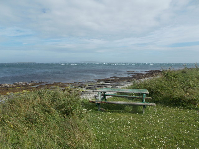
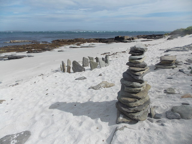
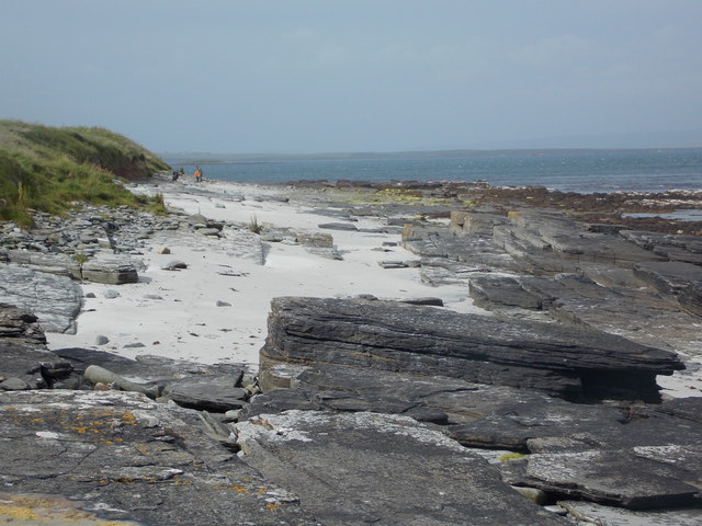
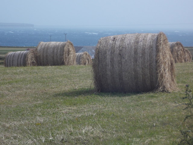
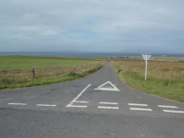
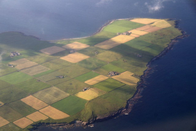
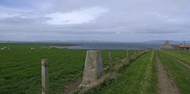
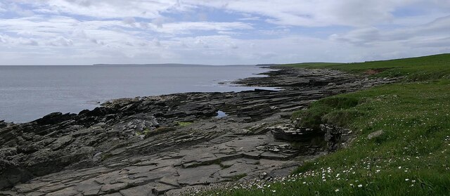
The Banks of Veniver, located in Orkney, Scotland, are an impressive geological feature consisting of steep cliffs and slopes. Situated on the northern coast of the main island, these banks stretch for approximately 3 miles along the coastline. The cliffs, which reach heights of up to 200 feet, are composed of sandstone and shale, displaying layers that provide a glimpse into the region's geological history.

The Banks of Veniver offer breathtaking views of the North Sea, with its crashing waves and dramatic tides. The cliffs are home to a diverse range of seabird colonies, including guillemots, puffins, and razorbills, making it a popular spot for birdwatchers and nature enthusiasts.

The slopes leading down from the cliffs are covered in lush vegetation, including grasses, heather, and wildflowers such as primroses and sea pinks. The combination of the rugged cliffs and vibrant flora creates a visually stunning landscape that attracts both locals and tourists alike.

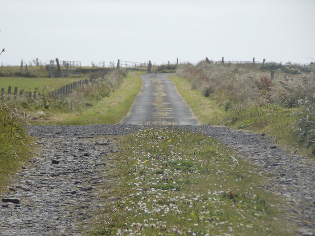
Due to their remote location, the Banks of Veniver provide a peaceful and serene environment, ideal for those seeking solitude and a connection with nature. The area is also a designated Site of Special Scientific Interest (SSSI), recognizing its importance for both its geological and ecological significance.

Overall, the Banks of Veniver in Orkney are a remarkable natural feature, combining towering cliffs, vibrant slopes, and abundant wildlife. Whether admired from the top of the cliffs or explored up close, this area offers a captivating glimpse into the geological and biological diversity of the region.

If you have any feedback on the listing, please let us know in the comments section below.

Banks of Veniver Images

Images are sourced within 2km of 59.078479/-2.8296564 or Grid Reference HY5221. Thanks to Geograph Open Source API. All images are credited.

Shapinsay: picnic bench at the north end A picnic bench occupies a pleasant position, just by the end of the road and with good views across to Eday, which we can just make out in the distance.
Shapinsay: picnic bench at the north end
A picnic bench occupies a pleasant position, just by the end of the road and with good views across to Eday, which we can just make out in the distance.
Shapinsay: non-antiquities on the beach A small stone circle and a pile of stones have been put up by a visitor to this small but picturesque beach at the northern end of the island.
Shapinsay: non-antiquities on the beach
A small stone circle and a pile of stones have been put up by a visitor to this small but picturesque beach at the northern end of the island.
Shapinsay: sandy and rocky beach A nice beach at the northern end of the island. I wonder if the dad and son in the background were as surprised as we were not to be the only visitors.
Shapinsay: sandy and rocky beach
A nice beach at the northern end of the island. I wonder if the dad and son in the background were as surprised as we were not to be the only visitors.
Shapinsay: Hillock Road Surprisingly named on the 1:25,000 map, this little lane is a continuation of the B9058, at right angles to it. The beach is just behind us.
Shapinsay: Hillock Road
Surprisingly named on the 1:25,000 map, this little lane is a continuation of the B9058, at right angles to it. The beach is just behind us.
Shapinsay: Borroughston Broch One of many brochs, or remains of, in Orkney, the one here was excavated in the 1860s but fell into poor condition again before being properly restored in the 1990s.
Shapinsay: Borroughston Broch
One of many brochs, or remains of, in Orkney, the one here was excavated in the 1860s but fell into poor condition again before being properly restored in the 1990s.
Shapinsay: Borroughston Broch from the north Another view of <a href="https://www.geograph.org.uk/photo/4714329">HY5421 : Shapinsay: Borroughston Broch</a>, from the opposite side.
Shapinsay: Borroughston Broch from the north
Another view of HY5421 : Shapinsay: Borroughston Broch, from the opposite side.
Shapinsay: a line of running cows Maybe 'running' is a bit of an exaggeration, but these cows approached us in line at a bit of a canter before deciding that there was nothing to interest them. A few minutes later they did the same, in similar formation, at the far end of the field.
Shapinsay: a line of running cows
Maybe 'running' is a bit of an exaggeration, but these cows approached us in line at a bit of a canter before deciding that there was nothing to interest them. A few minutes later they did the same, in similar formation, at the far end of the field.
Shapinsay: the B9058 heads north Looking along the last dead-straight mile of the main road across the island.
Shapinsay: the B9058 heads north
Looking along the last dead-straight mile of the main road across the island.
Shapinsay: hay bales and a sea view Looking across one of the square patchwork fields of the island, with Rothiesholm Head on Stronsay in the distance.
Shapinsay: hay bales and a sea view
Looking across one of the square patchwork fields of the island, with Rothiesholm Head on Stronsay in the distance.
Shapinsay: postbox № KW17 57 A standard lamp box dating from post-1994, mounted on an unusually short metal pole. Serving the northern part of the island, it is one of four postboxes on Shapinsay.
Shapinsay: postbox № KW17 57
A standard lamp box dating from post-1994, mounted on an unusually short metal pole. Serving the northern part of the island, it is one of four postboxes on Shapinsay.
Shapinsay: the road to Quholm A road runs at right-angles from the main B9058, and the regular angularity is no accident: David Balfour, who owned the island in the mid-1800s, divided most of the land into fields of 4 hectares - and it is particularly evident from aerial photography or large-scale mapping that this was done in a patchwork of squares. It is therefore natural that the roads will be straight and at right-angles to one another.
Shapinsay: the road to Quholm
A road runs at right-angles from the main B9058, and the regular angularity is no accident: David Balfour, who owned the island in the mid-1800s, divided most of the land into fields of 4 hectares - and it is particularly evident from aerial photography or large-scale mapping that this was done in a patchwork of squares. It is therefore natural that the roads will be straight and at right-angles to one another.
Shapinsay: red phone box on the B9058 The phone box stands alongside the road but far enough onto someone's garden that it is probably the location of the former North Shapinsay post office, which existed from 1935 until closure on 30 June 1975.
Shapinsay: red phone box on the B9058
The phone box stands alongside the road but far enough onto someone's garden that it is probably the location of the former North Shapinsay post office, which existed from 1935 until closure on 30 June 1975.
Ness of Ork, Shapinsay, from the air
Triangulation pillar, Ness of Ork, Shapinsay, Orkney Looking west towards the coast at Noust of Erraby.
Triangulation pillar, Ness of Ork, Shapinsay, Orkney
Looking west towards the coast at Noust of Erraby.
Point of Duresse, Shapinsay, Orkney Mull Head on Orkney Mainland can be seen on the left of the horizon.
Point of Duresse, Shapinsay, Orkney
Mull Head on Orkney Mainland can be seen on the left of the horizon.
Broch of Burroughston This is the entrance passageway to the broch, which is sufficiently well preserved to be readily recognisable as such.  It is a Scheduled Ancient Monument. See <span class="nowrap"><a title="https://portal.historicenvironment.scot/designation/SM1421" rel="nofollow ugc noopener" href="https://portal.historicenvironment.scot/designation/SM1421">Link</a><img style="margin-left:2px;" alt="External link" title="External link - shift click to open in new window" src="https://s1.geograph.org.uk/img/external.png" width="10" height="10"/></span> for details.
Broch of Burroughston
This is the entrance passageway to the broch, which is sufficiently well preserved to be readily recognisable as such. It is a Scheduled Ancient Monument. See LinkExternal link for details.
Broch of Burroughston The broch still stands to about a third of its likely original height, and its internal features, including stairs and the bases of partitions, have survived. It is a Scheduled Ancient Monument. See <span class="nowrap"><a title="https://portal.historicenvironment.scot/designation/SM1421" rel="nofollow ugc noopener" href="https://portal.historicenvironment.scot/designation/SM1421">Link</a><img style="margin-left:2px;" alt="External link" title="External link - shift click to open in new window" src="https://s1.geograph.org.uk/img/external.png" width="10" height="10"/></span> for details.
Broch of Burroughston
The broch still stands to about a third of its likely original height, and its internal features, including stairs and the bases of partitions, have survived. It is a Scheduled Ancient Monument. See LinkExternal link for details.
Broch of Burroughston Looking down from the top of the wall, you get a reasonable idea of the internal layout, including the partitions that create smaller side chambers. The grating is modern, and covers the well. It is a Scheduled Ancient Monument. See <span class="nowrap"><a title="https://portal.historicenvironment.scot/designation/SM1421" rel="nofollow ugc noopener" href="https://portal.historicenvironment.scot/designation/SM1421">Link</a><img style="margin-left:2px;" alt="External link" title="External link - shift click to open in new window" src="https://s1.geograph.org.uk/img/external.png" width="10" height="10"/></span> for details.
Broch of Burroughston
Looking down from the top of the wall, you get a reasonable idea of the internal layout, including the partitions that create smaller side chambers. The grating is modern, and covers the well. It is a Scheduled Ancient Monument. See LinkExternal link for details.
Show me another place!

Banks of Veniver is located at Grid Ref: HY5221 (Lat: 59.078479, Lng: -2.8296564)

Unitary Authority: Orkney Islands

Police Authority: Highlands and Islands

What 3 Words

///districts.lowest.birds. Near Balfour, Orkney Islands

Related Wikis

Quholm

Quholm (grid reference HY5221) is a farm in the northeast of Shapinsay, in the islands of Orkney, Scotland. == Historical sites == Slightly to the south...
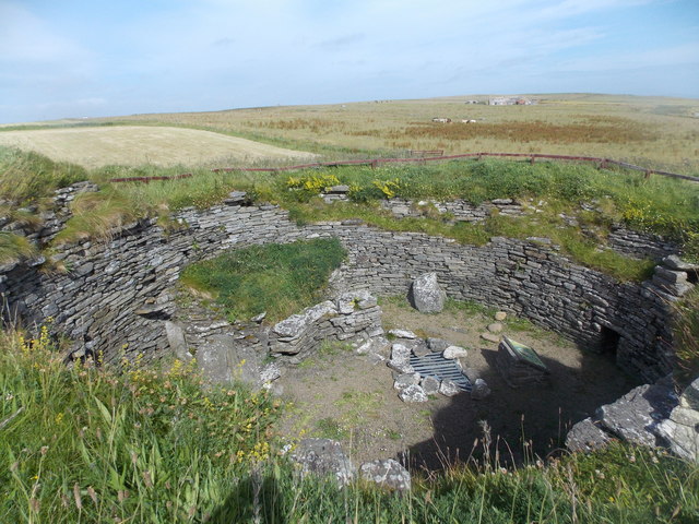
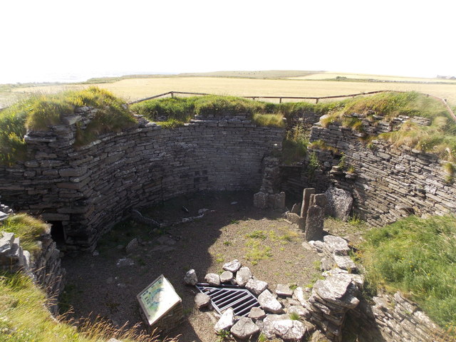
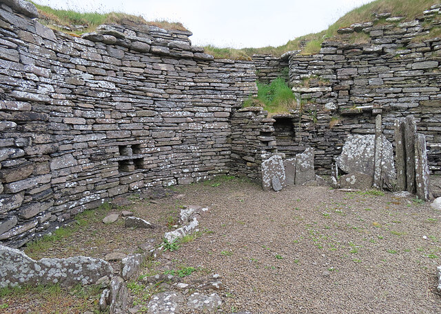
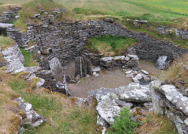
Burroughston Broch

Burroughston Broch is an Iron Age broch located on the island of Shapinsay in the Orkney Islands, in Scotland (grid reference HY54062100). The site overlooks...

Veantro Bay

Veantro Bay is a bay on the northwest coast of Shapinsay in the Orkney Islands, Scotland.At the head of the bay is a large stone, thought to be associated...

Lairo Water

Lairo Water is a surface water body known as an ayre situated on the western coast of Shapinsay in the Orkney Islands. This brackish water body is separated...

Nearby Amenities

Located within 500m of 59.078479,-2.8296564
Quholm
Place: hamlet
Wikidata: Q7271620
Wikipedia: en:Quholm
Lat/Long: 59.0760471/-2.8363395
Power: pole
Lat/Long: 59.0763338/-2.8362536
Power: pole
Lat/Long: 59.0756777/-2.8364682
Power: pole
Lat/Long: 59.0747238/-2.8342903
Power: pole
Lat/Long: 59.0748465/-2.8329036
Power: pole
Lat/Long: 59.0750423/-2.8315008
Power: pole
Lat/Long: 59.0747624/-2.830452
Power: pole
Lat/Long: 59.0741918/-2.8282875
Cairn (beacon stance)
Historic: archaeological_site
Lat/Long: 59.0753634/-2.832612
The data included in this document is from www.openstreetmap.org. The data is made available under ODbL.

Have you been to Banks of Veniver?

Leave your review of Banks of Veniver below (or comments, questions and feedback).