Rascarrel Heugh

Cliff, Slope in Kirkcudbrightshire

Scotland

Rascarrel Heugh

Shore with boulders Rounded glacial boulders, many of granite, are a feature of the upper shore at Lochenling.
Shore with boulders Credit: Jonathan Wilkins

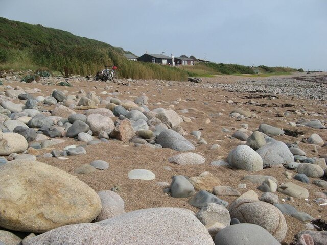
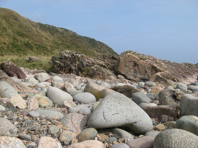
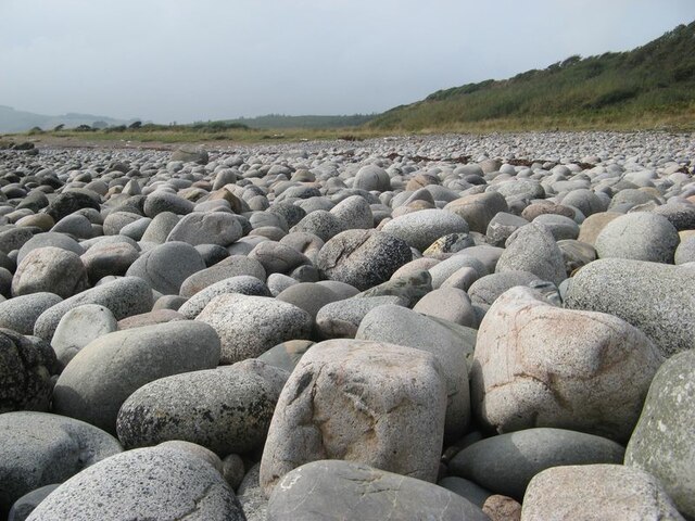
Rascarrel Heugh is a prominent cliff located in Kirkcudbrightshire, a historic county in southwest Scotland. Situated on the southern coast of the country, this natural feature is known for its stunning views and geological significance. The heugh stands tall, rising approximately 60 meters above the surrounding landscape, making it an impressive sight for visitors and locals alike.

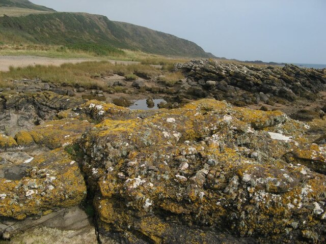
The cliff is composed mainly of sedimentary rocks, with layers that reveal a diverse range of geological formations. These formations are of great interest to geologists, as they provide valuable insights into the history and evolution of the region. The layers of sandstone, shale, and limestone found in Rascarrel Heugh can be traced back millions of years, offering a glimpse into the ancient marine environments that once existed in this area.

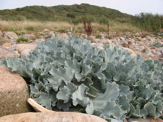
Access to Rascarrel Heugh is relatively easy, with a path leading up to the cliff's edge. From the top, visitors can enjoy panoramic views of the surrounding countryside, the nearby Solway Firth, and even catch a glimpse of the distant mountains on a clear day. The heugh also serves as a nesting site for various bird species, including seabirds such as cormorants and gulls, adding to the natural beauty and wildlife diversity of the area.

Overall, Rascarrel Heugh is a captivating natural feature that combines breathtaking views, geological significance, and a haven for birdlife. It offers visitors a chance to immerse themselves in the natural wonders of Kirkcudbrightshire and appreciate the region's rich geological history.

If you have any feedback on the listing, please let us know in the comments section below.

Rascarrel Heugh Images

Images are sourced within 2km of 54.806189/-3.8689809 or Grid Reference NX7947. Thanks to Geograph Open Source API. All images are credited.

Shore with boulders Rounded glacial boulders, many of granite, are a feature of the upper shore at Lochenling.
Shore with boulders
Rounded glacial boulders, many of granite, are a feature of the upper shore at Lochenling.
Sea kale A fabulous specimen of sea kale, Crambe maritima, growing amid boulders above the tide line. Other seedlings were dotted about nearby on the edge of the raised beach.
Sea kale
A fabulous specimen of sea kale, Crambe maritima, growing amid boulders above the tide line. Other seedlings were dotted about nearby on the edge of the raised beach.
Rock outcrops Rock outcrops here belong to the Rascarrel member of the Fell Sandstone Formation which are of Carboniferous (Arundian to Holkerian) age. Rapid variation in the composition and grain size of these sandstones and conglomerates are due to very active faulting on the edge of the Solway Basin, but prominent among recognisable clasts are lumps of granitic rock from the weathering of the nearby intrusion. The camera location is a stack which is above the tide level and has a thick encrustation of lichens, mostly yellow Caloplaca.
Rock outcrops
Rock outcrops here belong to the Rascarrel member of the Fell Sandstone Formation which are of Carboniferous (Arundian to Holkerian) age. Rapid variation in the composition and grain size of these sandstones and conglomerates are due to very active faulting on the edge of the Solway Basin, but prominent among recognisable clasts are lumps of granitic rock from the weathering of the nearby intrusion. The camera location is a stack which is above the tide level and has a thick encrustation of lichens, mostly yellow Caloplaca.
Path to Loch Mackie Rampant bracken has taken hold following the felling of adjacent forestry, but isolated rowans have good colour with abundant berries.
Path to Loch Mackie
Rampant bracken has taken hold following the felling of adjacent forestry, but isolated rowans have good colour with abundant berries.
Rock outcrops Low rock outcrops on the edge of the raised beach comprise dipping beds of sandstone belonging to the Rascarrel Member of the Fell Sandstone Formation. In the background is the steep, seaward face of Airds Heugh.
Rock outcrops
Low rock outcrops on the edge of the raised beach comprise dipping beds of sandstone belonging to the Rascarrel Member of the Fell Sandstone Formation. In the background is the steep, seaward face of Airds Heugh.
Boulder shore The shore here comprises an extraordinary carpet of equal-sized boulders of glacial origin which are the residua of former deposits of till, or boulder clay. It is part of the discontinuous raised beach which is particularly prominent through the west of the southern Scottish coast. See also, for example <a href="https://www.geograph.org.uk/photo/3121405">NX1239 : Bouldery beach</a>.
Boulder shore
The shore here comprises an extraordinary carpet of equal-sized boulders of glacial origin which are the residua of former deposits of till, or boulder clay. It is part of the discontinuous raised beach which is particularly prominent through the west of the southern Scottish coast. See also, for example NX1239 : Bouldery beach.
Shore path approaching Rascarrel Bay There's a widening area of grass and boulders here below the cliff line. Could this be a raised beach? The part vegetated cliff has a prominent carboniferous sandstone bluff above the path.
Shore path approaching Rascarrel Bay
There's a widening area of grass and boulders here below the cliff line. Could this be a raised beach? The part vegetated cliff has a prominent carboniferous sandstone bluff above the path.
Across Rascarrel Bay A gate here leads to another section of coast path keeping close to the shore. This is not a shoreline for sand castle building.
Across Rascarrel Bay
A gate here leads to another section of coast path keeping close to the shore. This is not a shoreline for sand castle building.
Loch Mackie Small loch, just 500m or so from the sea.
Loch Mackie
Small loch, just 500m or so from the sea.
Natural arch at Brock's Holes Scale is deceptive. You can walk both over and under this arch - although, ideally, in calmer weather than this!
Natural arch at Brock's Holes
Scale is deceptive. You can walk both over and under this arch - although, ideally, in calmer weather than this!
Loch Mackie with Bengairn Hills behind Loch Mackie is small loch. Looking northwest to hills behind Screel. Bengairn, Bentudor and Screel Hill.
Loch Mackie with Bengairn Hills behind
Loch Mackie is small loch. Looking northwest to hills behind Screel. Bengairn, Bentudor and Screel Hill.
Path across the moss Footpath leading across Auchencairn Moss towards Loch Mackie and Balcary
Path across the moss
Footpath leading across Auchencairn Moss towards Loch Mackie and Balcary
Sign of the times This signpost caught my eye as so weathered as to be virtually illegible. It's only about ten years old.
Sign of the times
This signpost caught my eye as so weathered as to be virtually illegible. It's only about ten years old.
Big Airds Hill Looks like a good site for an Iron Age Fort.....perhaps there was one.
Big Airds Hill
Looks like a good site for an Iron Age Fort.....perhaps there was one.
Early spring growth The shore was littered with driftwood and plastic rubbish. Bracken appeared to have burnt last year but the bluebells and other vegetation will soon make this scene pretty.
Early spring growth
The shore was littered with driftwood and plastic rubbish. Bracken appeared to have burnt last year but the bluebells and other vegetation will soon make this scene pretty.
Attractive shore features Endless fun to be had searching the rockpools......
Attractive shore features
Endless fun to be had searching the rockpools......
Footpath and gorse The gorse in this area grew bigger than I expected so perhaps it's a different variety.
Footpath and gorse
The gorse in this area grew bigger than I expected so perhaps it's a different variety.
Loch Mackie
Loch Mackie
Show me another place!

Rascarrel Heugh is located at Grid Ref: NX7947 (Lat: 54.806189, Lng: -3.8689809)

Unitary Authority: Dumfries and Galloway

Police Authority: Dumfries and Galloway

What 3 Words

///euphoric.decorated.rosier. Near Kirkcudbright, Dumfries & Galloway

Related Wikis

Urr Water

Urr Water or River Urr (arc. River Orr) is a river in which flows through the counties of Dumfriesshire and Kirkcudbrightshire in southwest Scotland....

Wickerman Festival

The Wickerman Festival was an annual music festival held near Auchencairn in Dumfries and Galloway, Scotland. Dubbed "Scotland's Alternative Music festival...

Auchencairn

Auchencairn ([ɔxən'kʰɛ:(r)n]) is a village in the historical county of Kirkcudbrightshire in the Dumfries and Galloway region of Scotland. It is located...

Hestan Island

Hestan Island is a small coastal island at the southern foot of the River Urr estuary in the Solway Firth, in the historical county of Kirkcudbrightshire...

Dundrennan Abbey

Dundrennan Abbey, in Dundrennan, Scotland, near to Kirkcudbright, was a Cistercian monastery in the Romanesque architectural style, established in 1142...

Dundrennan

Dundrennan (Gaelic: Dun Droighnein) is a village Dumfries and Galloway, Scotland, about 5 miles (8 km) east of Kirkcudbright. Its population is around...

Orchardton Castle

Orchardton Castle overlooks the Solway Coast. Built in the 1880s, this is a Grade B listed property formerly known as Orchardton House. Built around a...

Abbey Head

Abbey Head is a headland on the Solway Firth coast of Dumfries and Galloway. == References ==

Nearby Amenities

Located within 500m of 54.806189,-3.8689809
Source: PGS
Lat/Long: 54.8035963/-3.8736267
Source: PGS
Lat/Long: 54.8041173/-3.8735839
Source: PGS
Lat/Long: 54.8043427/-3.8733082
Source: PGS
Lat/Long: 54.8044736/-3.8727
Source: PGS
Lat/Long: 54.8043215/-3.8721177
Source: PGS
Lat/Long: 54.8044274/-3.8717743
Source: PGS
Lat/Long: 54.804693/-3.8716946
Source: PGS
Lat/Long: 54.8046428/-3.8713849
Source: PGS
Lat/Long: 54.8048531/-3.8714446
Source: PGS
Lat/Long: 54.804974/-3.8706683
Source: PGS
Lat/Long: 54.8050237/-3.8701298
Source: PGS
Lat/Long: 54.8052973/-3.8700212
Source: PGS
Lat/Long: 54.8053038/-3.869834
Source: PGS
Lat/Long: 54.805617/-3.8697772
Source: PGS
Lat/Long: 54.8052405/-3.8693452
Source: PGS
Lat/Long: 54.8059001/-3.8690576
Source: PGS
Lat/Long: 54.8064874/-3.8682484
Source: PGS
Lat/Long: 54.8067374/-3.868318
Source: PGS
Lat/Long: 54.8082322/-3.8676541
Source: PGS
Lat/Long: 54.8085123/-3.8672978
Source: PGS
Lat/Long: 54.8089038/-3.8673646
Source: PGS
Lat/Long: 54.8094103/-3.8671585
Source: PGS
Lat/Long: 54.8099097/-3.8668429
Castle Muir
Alt Name: Castle Rueberry
Historic: archaeological_site
Source: Popular Edition (Scotland);https://www.stravaiging.com/history/castle/castle-muir/;https://hillforts.arch.ox.ac.uk/records/SC0269.html
Website: https://clanmuir.site123.me/clan-muir-s-castles
Lat/Long: 54.8052479/-3.8724499
The data included in this document is from www.openstreetmap.org. The data is made available under ODbL.

Have you been to Rascarrel Heugh?

Leave your review of Rascarrel Heugh below (or comments, questions and feedback).