Tregantle Cliff

Cliff, Slope in Cornwall

England

Tregantle Cliff

On SW Coast Path - view W above Trethill Cliffs
On SW Coast Path - view W above Trethill Cliffs Credit: Colin Park

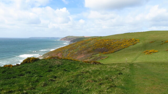
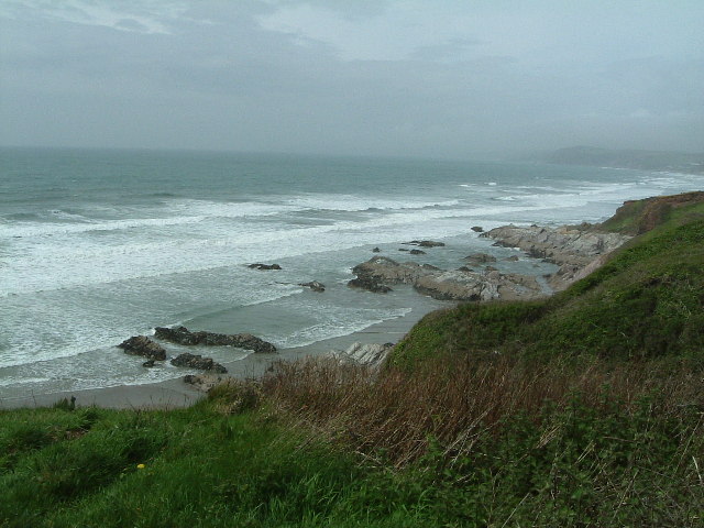
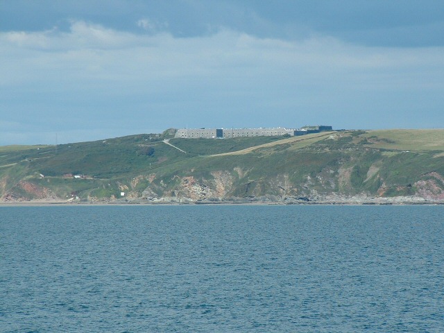
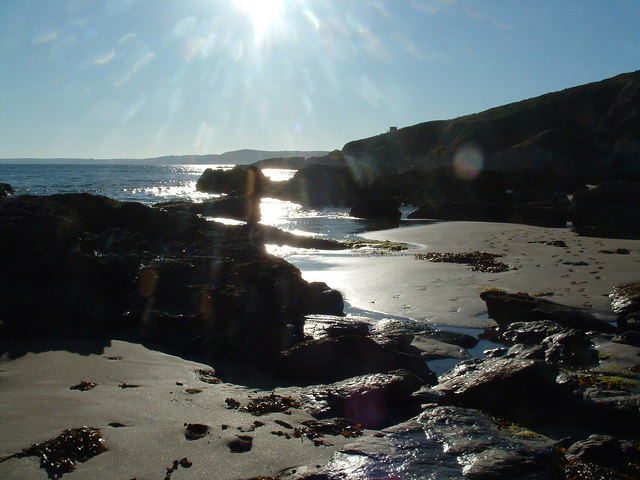
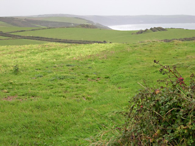
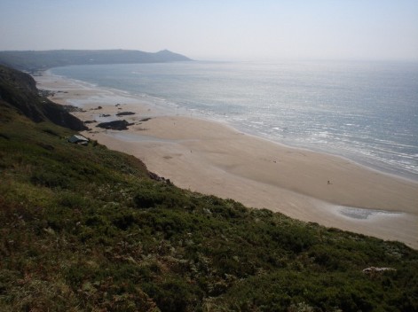
Tregantle Cliff is a prominent cliff located on the southeastern coast of Cornwall, England. It stretches for approximately 1.5 miles, forming a dramatic coastline with stunning views of the English Channel. The cliff is situated near the small village of Whitsand Bay and is a popular destination for locals and tourists alike.

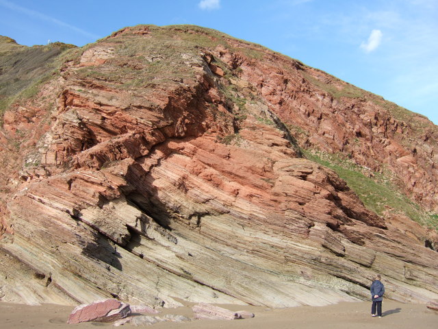
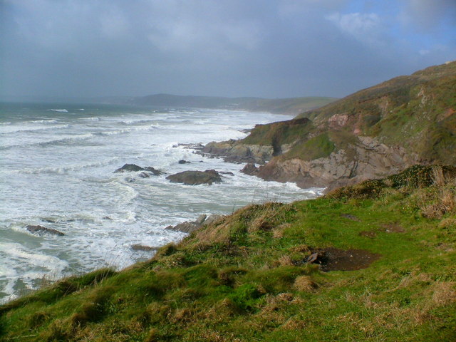
Standing at an impressive height of around 300 feet, Tregantle Cliff offers visitors a breathtaking perspective of the surrounding landscape. The cliff is made up of layers of sedimentary rocks, including sandstone and shale, which have been shaped by natural erosion over millions of years. This erosion process has created a rugged and jagged appearance, adding to the cliff's allure.

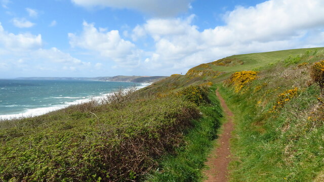
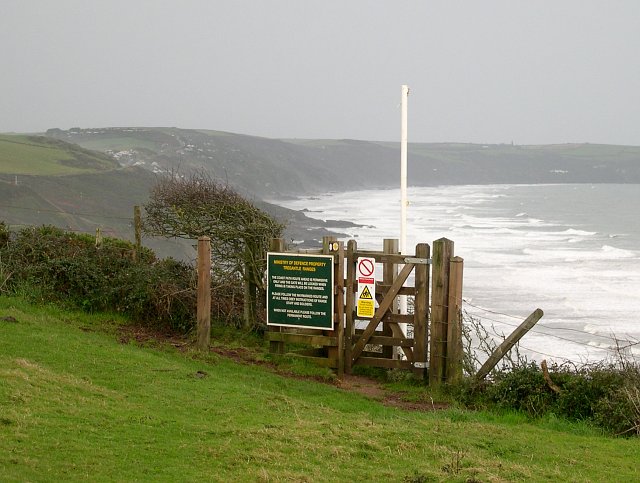
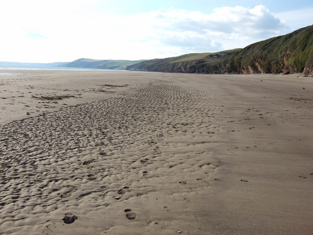
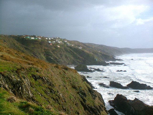
Due to its steepness, Tregantle Cliff is not easily accessible for exploration. However, there are designated paths and trails that lead to viewpoints, allowing visitors to marvel at the panoramic vistas. The cliff's slopes are covered in lush vegetation, including grasses, wildflowers, and shrubs, providing a vibrant and picturesque scene.

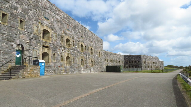
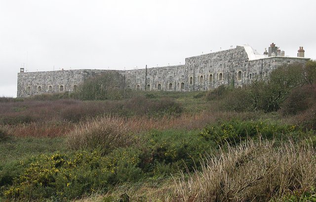
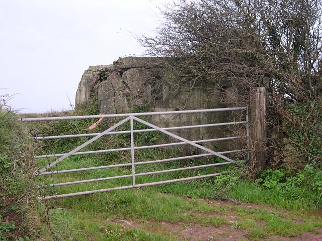
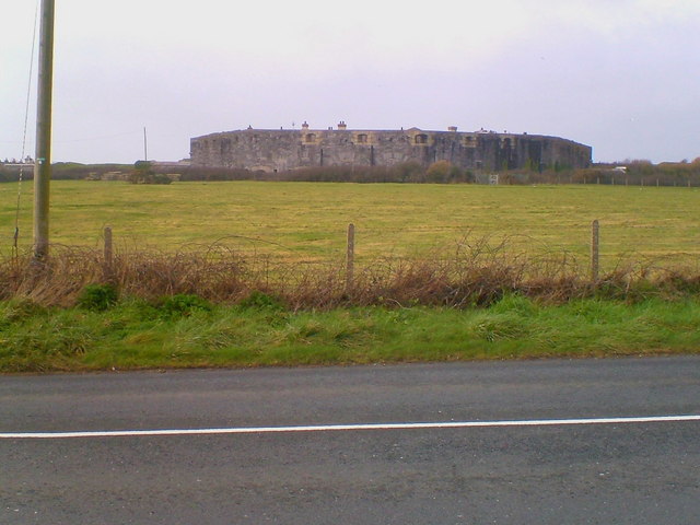
Tregantle Cliff is also renowned for its historical significance. It was once the site of a military training facility known as Tregantle Fort, which was constructed in the late 19th century and played a crucial role during World War II. Today, the fort is still in use by the British Army and is a restricted area. However, visitors can observe the fort from a distance while enjoying the awe-inspiring beauty of Tregantle Cliff.

In conclusion, Tregantle Cliff is a magnificent natural formation that offers stunning views, rich biodiversity, and a glimpse into Cornwall's military history. It is a must-visit destination for nature enthusiasts and those looking to immerse themselves in the beauty of the Cornish coastline.

If you have any feedback on the listing, please let us know in the comments section below.

Tregantle Cliff Images

Images are sourced within 2km of 50.351666/-4.2686473 or Grid Reference SX3852. Thanks to Geograph Open Source API. All images are credited.

On SW Coast Path - view W above Trethill Cliffs
Tregantle Fort near Antony Tregantle Fort is one of several forts surrounding Plymouth that were built as a result of a decision in Lord Palmerston's premiership to deter the French from attacking naval bases on the Channel coast. The fort was originally designed by Captain William Crossman, with later modifications by Captain (later Maj General) Edmund Frederick Du Cane. Construction commenced in 1859 and was completed in 1865. When originally designed it had provision for 35 large guns. By 1893 the guns consisted of five RBL 7 inch Armstrong guns and nineteen RML 64-pounders, together with a number of 32 Pounder Smooth Bore Breech Loading guns. Early in the 1900s it became an infantry battalion headquarters with 14 officers and 423 other ranks, and from 1903 was used for rifle training. Tregantle is infamous within the armed forces because many of the rifle ranges located there slope steeply down towards the sea. These ranges are still in use, primarily by personnel located at HMS Raleigh. Tregantle was vacated after World War I until 1938, when it was used as the Territorial Army Passive Air Defence School. During World War II it was used first as the Army Gas School and from 1942 as US Army accommodation. (source Wikipedia)
Tregantle Fort near Antony
Tregantle Fort is one of several forts surrounding Plymouth that were built as a result of a decision in Lord Palmerston's premiership to deter the French from attacking naval bases on the Channel coast. The fort was originally designed by Captain William Crossman, with later modifications by Captain (later Maj General) Edmund Frederick Du Cane. Construction commenced in 1859 and was completed in 1865. When originally designed it had provision for 35 large guns. By 1893 the guns consisted of five RBL 7 inch Armstrong guns and nineteen RML 64-pounders, together with a number of 32 Pounder Smooth Bore Breech Loading guns. Early in the 1900s it became an infantry battalion headquarters with 14 officers and 423 other ranks, and from 1903 was used for rifle training. Tregantle is infamous within the armed forces because many of the rifle ranges located there slope steeply down towards the sea. These ranges are still in use, primarily by personnel located at HMS Raleigh. Tregantle was vacated after World War I until 1938, when it was used as the Territorial Army Passive Air Defence School. During World War II it was used first as the Army Gas School and from 1942 as US Army accommodation. (source Wikipedia)
SW Coast Path between Tregantle Down & Freathy
Tregantle Rifle Range and The Kodima This photograph looks out to sea over one of the rifle ranges at Tregantle Fort, although at this time it looks more like a timber yard.  The ship beached in the bay is the Kodima which was stranded in heavy seas on 2nd February 2002.  This photograph was taken 2 weeks later just before it was refloated.  The ship was carrying a cargo of timber planks, much of which was washed up on local beaches and subsequently "liberated" by local people indulging in one of the oldest Cornish Traditions.  Officials protested that this activity was against the law  and generally not cricket but nobody paid much attention.  A local pub put out a sign saying "Wreckers welcome".
Tregantle Rifle Range and The Kodima
This photograph looks out to sea over one of the rifle ranges at Tregantle Fort, although at this time it looks more like a timber yard. The ship beached in the bay is the Kodima which was stranded in heavy seas on 2nd February 2002. This photograph was taken 2 weeks later just before it was refloated. The ship was carrying a cargo of timber planks, much of which was washed up on local beaches and subsequently "liberated" by local people indulging in one of the oldest Cornish Traditions. Officials protested that this activity was against the law and generally not cricket but nobody paid much attention. A local pub put out a sign saying "Wreckers welcome".
Entrance to the path by Tregantle Fort This permissive path is one of the most recently opened sections of the South West Coast Path.  It is closed when the MOD firing ranges at Tregantle are being used, at which times walkers must take a detour to the landward side of the fort.
Entrance to the path by Tregantle Fort
This permissive path is one of the most recently opened sections of the South West Coast Path. It is closed when the MOD firing ranges at Tregantle are being used, at which times walkers must take a detour to the landward side of the fort.
Tregantle Fort This 19th century fortification was completed in 1865 and overlooks Whitsand Bay.   The intention of the fort was to hold guns which could fire on ships at sea.  Whilst its guns were upgraded in the late 19th century they did not keep pace with the advances in naval guns at the time.  Tregantle Forts most famous resident was probably the American heavyweight boxing champion Joe Louis who was stationed here for a time in the Second World War.  This photograph shows the southwestern aspect of the fort.  The fort and its surrounds now contain rife ranges for military practice.
Tregantle Fort
This 19th century fortification was completed in 1865 and overlooks Whitsand Bay. The intention of the fort was to hold guns which could fire on ships at sea. Whilst its guns were upgraded in the late 19th century they did not keep pace with the advances in naval guns at the time. Tregantle Forts most famous resident was probably the American heavyweight boxing champion Joe Louis who was stationed here for a time in the Second World War. This photograph shows the southwestern aspect of the fort. The fort and its surrounds now contain rife ranges for military practice.
Clampet Lane A narrow lane through mixed agricultural land to the north of Whitsand Bay.
Clampet Lane
A narrow lane through mixed agricultural land to the north of Whitsand Bay.
Higher Tregantle Farm
World War II Pillbox This old pillbox sits decaying in the corner of a field.
World War II Pillbox
This old pillbox sits decaying in the corner of a field.
Looking out to sea near Sharrow Point Sharrow Point juts out to sea on Whitsand Bay near Freathy.
For a similar view, but on a much sunnier day taken 7 years later - see <a href="https://www.geograph.org.uk/photo/2145314">SX3952 : Whitsand Bay looking west from Sharrow Point</a>
Looking out to sea near Sharrow Point
Sharrow Point juts out to sea on Whitsand Bay near Freathy. For a similar view, but on a much sunnier day taken 7 years later - see SX3952 : Whitsand Bay looking west from Sharrow Point
Rock Formation, Blarrick Cliff This rosy cliff rises from the "Danger Area" beach below Tregantle Fort. (It's only a Danger Area when the red flags are flying signifying that they're using the firing ranges)
Rock Formation, Blarrick Cliff
This rosy cliff rises from the "Danger Area" beach below Tregantle Fort. (It's only a Danger Area when the red flags are flying signifying that they're using the firing ranges)
Long Sands near Tregantle O.k. - a bit cheeky this one - but by my reckoning I've got the bit of sand that sneaks into SX3752 in this shot !
Edit: See a later shot, definitely taken within the square here <a href="https://www.geograph.org.uk/photo/2538409">SX3752 : Long Sands at very low tide</a>
Long Sands near Tregantle
O.k. - a bit cheeky this one - but by my reckoning I've got the bit of sand that sneaks into SX3752 in this shot ! Edit: See a later shot, definitely taken within the square here SX3752 : Long Sands at very low tide
Fort Tregantle from the sea
Tregantle Fort Part of the fort near the viewpoint carpark.
Tregantle Fort
Part of the fort near the viewpoint carpark.
National Trust Coastline The turbulent sea at Sharrow Point
National Trust Coastline
The turbulent sea at Sharrow Point
Coastline near Freathy The dramatic coastline with Freathy perched on the cliffs.
Coastline near Freathy
The dramatic coastline with Freathy perched on the cliffs.
Freathy Beach Evening scene looking towards Looe
Freathy Beach
Evening scene looking towards Looe
Coastal Pastures It is a typically damp November day on the farmland above Whitsand Bay.  The coast road is marked by the double hedge line.
Coastal Pastures
It is a typically damp November day on the farmland above Whitsand Bay. The coast road is marked by the double hedge line.
Show me another place!

Tregantle Cliff is located at Grid Ref: SX3852 (Lat: 50.351666, Lng: -4.2686473)

Unitary Authority: Cornwall

Police Authority: Devon and Cornwall

What 3 Words

///nitrate.online.toasters. Near Millbrook, Cornwall

Related Wikis

Tregantle Down Battery

Tregantle Down Battery was a high angle gun battery in south east Cornwall. It was built between 1888 and 1894 to defend HMNB Devonport from Whitsand Bay...

Tregantle Fort

Tregantle Fort in south east Cornwall is one of several forts surrounding Plymouth that were built as a result of a decision in Lord Palmerston's premiership...

Lower Tregantle

Lower Tregantle is a hamlet in Cornwall, England, UK. It is about half a mile south of Antony; Higher Tregantle is about a quarter of a mile further south...

Freathy

Freathy (Cornish: Frydhi) is a beach and coastal settlement on the Rame Peninsula in east Cornwall, England, United Kingdom.Freathy is accessible by the...

Church of St James, Antony

The Church of St James is a Grade I listed 12th-century Anglican parish church in Antony, Cornwall, England. == History == The church is located in Antony...

Scraesdon Fort

Scraesdon Fort, near the village of Antony, is one of several forts in South East Cornwall which formed part of the ring of forts surrounding Plymouth...

Whitsand Bay

Whitsand Bay, situated in south east Cornwall, England, runs from Rame Head in the east to Portwrinkle in the west. It is characterised by sheer, high...

Antony, Cornwall

Antony (Cornish: Trevanta) is a coastal civil parish and a village in Cornwall, England, United Kingdom. The village is situated on the Rame Peninsula...

Nearby Amenities

Located within 500m of 50.351666,-4.2686473
Barrier: kissing_gate
Description: Gate locked when firing ranges in use, indicated by red flags flying nearby, or red lights at night.
Foot: permissive
Lat/Long: 50.3545357/-4.2655532
The data included in this document is from www.openstreetmap.org. The data is made available under ODbL.

Have you been to Tregantle Cliff?

Leave your review of Tregantle Cliff below (or comments, questions and feedback).