Clò Mòr

Cliff, Slope in Sutherland

Scotland

Clò Mòr

Kearvaig beach and bothy
Kearvaig beach and bothy Credit: Simon Bonney

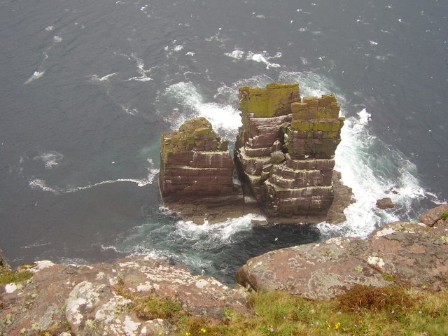
Clò Mòr is a prominent cliff or slope located in Sutherland, a historic county in the northernmost part of mainland Scotland. Rising majestically above the surrounding landscape, Clò Mòr is known for its breathtaking natural beauty and rugged charm.

The cliff stands tall at an impressive height, offering stunning panoramic views of the surrounding countryside and the North Sea beyond. Its steep, rocky face is a result of thousands of years of geological processes, shaped by the forces of nature. The layers of sedimentary rock that make up Clò Mòr provide valuable insights into the area's geological history.

The location of Clò Mòr also adds to its allure. Situated in a remote and sparsely populated area, the cliff offers a sense of tranquility and seclusion. The surrounding countryside is characterized by rolling hills, moorland, and picturesque lochs, adding to the scenic appeal of the area.

For nature enthusiasts and avid hikers, Clò Mòr presents an opportunity for exploration and adventure. The cliff's challenging terrain attracts climbers and mountaineers, who test their skills against its steep slopes. The surrounding area also offers numerous walking trails and paths, allowing visitors to immerse themselves in the stunning natural environment.

In addition to its natural beauty, Clò Mòr holds cultural and historical significance. It has been a source of inspiration for artists and writers, who have captured its grandeur in their works. The cliff's Gaelic name, Clò Mòr, translates to "big slope," reflecting the awe-inspiring scale of the geological feature.

Overall, Clò Mòr stands as a remarkable testament to the power and beauty of nature. Its towering presence, breathtaking views, and secluded location make it a must-visit destination for those seeking an authentic Scottish experience.

If you have any feedback on the listing, please let us know in the comments section below.

Clò Mòr Images

Images are sourced within 2km of 58.6134/-4.9173265 or Grid Reference NC3073. Thanks to Geograph Open Source API. All images are credited.

Kearvaig beach and bothy
Kearvaig cliffs and Stack Clo Kearvaig
Kearvaig Bay Cape Wrath in the far distance, shortly after a storm has passed through.
Kearvaig Bay
Cape Wrath in the far distance, shortly after a storm has passed through.
Kearvaig Bothy Kearvaig from the Western slopes of the Clo More Cliffs.
Kearvaig Bothy
Kearvaig from the Western slopes of the Clo More Cliffs.
Kearvaig Bothy Now painted white
Kearvaig Bothy
Now painted white
Kearvaig Bothy
Kearvaig Bothy
Kearvaig Bay
Kearvaig Bay
Stack Clo Kearvaig
Stack Clo Kearvaig
Kearvaig beach A superb view down to the beach and the stack Clo Kearvaig from the side of the road to the lighthouse.
Kearvaig beach
A superb view down to the beach and the stack Clo Kearvaig from the side of the road to the lighthouse.
4 Mile Marker From the lighthouse.

I've located this by measuring the distance on the map. Thought it would be easy. I stand to be corrected.
4 Mile Marker
From the lighthouse. I've located this by measuring the distance on the map. Thought it would be easy. I stand to be corrected.
Cairn Near to the Kearvaig junction but not close enough to be a sign for.
Cairn
Near to the Kearvaig junction but not close enough to be a sign for.
A Hut and a Container At the junction to Kearvaig bothy.
A Hut and a Container
At the junction to Kearvaig bothy.
Old Milestone in Durness Parish, Cape Wrath peninsula By the UC road, in parish of Durness (Highland District), Cape Wrath peninsula.

Inscription reads:- : 5 : (To Cape Wrath)

Surveyed

Milestone Society National ID: HI_CWKD05
Old Milestone in Durness Parish, Cape Wrath peninsula
By the UC road, in parish of Durness (Highland District), Cape Wrath peninsula. Inscription reads:- : 5 : (To Cape Wrath) Surveyed Milestone Society National ID: HI_CWKD05
At the Kearvaig junction
Down Kearvaig river, towards Kearvaig Bay
Cape Wrath at sunset from Kervaig Sunset seen from the Bothy looking along the cliffs towards Cape Wrath
Cape Wrath at sunset from Kervaig
Sunset seen from the Bothy looking along the cliffs towards Cape Wrath
Cape Wrath from Kervaig A misty view of the Cape Wrath cliffs from Kervaig as the day ends
Cape Wrath from Kervaig
A misty view of the Cape Wrath cliffs from Kervaig as the day ends
Stack Clò Kearvaig Viewed from the road from Cape Wrath.
Stack Clò Kearvaig
Viewed from the road from Cape Wrath.
Show me another place!

Clò Mòr is located at Grid Ref: NC3073 (Lat: 58.6134, Lng: -4.9173265)

Unitary Authority: Highland

Police Authority: Highlands and Islands

What 3 Words

///steepest.buzzards.fresh. Near Oldshoremore, Highland

Nearby Locations

Clò Mòr Stac à' Chlò

Related Wikis

Cape Wrath

Cape Wrath (Scottish Gaelic: Am Parbh, known as An Carbh in Lewis) is a cape in the Durness parish of the county of Sutherland in the Highlands of Scotland...

Cape Wrath Lighthouse

Cape Wrath Lighthouse at Cape Wrath was built in 1828 by Robert Stevenson and was manned until 1998, when it was converted to automatic operation by the...

Achiemore, Durness

Achiemore was a crofting community located on the Cape Wrath peninsula near the village of Durness in the Scottish county of Sutherland. The hamlet is...

Faraid Head

Faraid Head (Scottish Gaelic: An Fharaird) is a small peninsula on the northern coast of Sutherland, Highland, Scotland, located around 2 miles (3 kilometres...

Balnakeil

Balnakeil is a hamlet in the parish of Durness, Sutherland, Scottish Highlands, and is in the Scottish council area of Highland. It is on the north coast...

Nearby Amenities

Located within 500m of 58.6134,-4.9173265
Created By: almien_coastlines
Source: PGS
Lat/Long: 58.614053/-4.909203
Created By: almien_coastlines
Source: PGS
Lat/Long: 58.614046/-4.909693
Created By: almien_coastlines
Source: PGS
Lat/Long: 58.614038/-4.910184
Created By: almien_coastlines
Source: PGS
Lat/Long: 58.613753/-4.912131
Source: PGS
Lat/Long: 58.6137233/-4.9130014
Source: PGS
Lat/Long: 58.613733/-4.9136309
Source: PGS
Lat/Long: 58.6137348/-4.9144403
Source: PGS
Lat/Long: 58.6137334/-4.915059
Source: PGS
Lat/Long: 58.6140492/-4.9170613
Source: PGS
Lat/Long: 58.614174/-4.9176143
Source: PGS
Lat/Long: 58.6147387/-4.9193062
Source: PGS
Lat/Long: 58.6155554/-4.9232056
Source: PGS
Lat/Long: 58.6152187/-4.9235669
Source: PGS
Lat/Long: 58.6151807/-4.9243055
Source: PGS
Lat/Long: 58.6153043/-4.9249572
Clò Mòr
Place: locality
Source: OS7
Lat/Long: 58.6120048/-4.9168434
The data included in this document is from www.openstreetmap.org. The data is made available under ODbL.

Have you been to Clò Mòr?

Leave your review of Clò Mòr below (or comments, questions and feedback).