Bidein na h-Iolaire

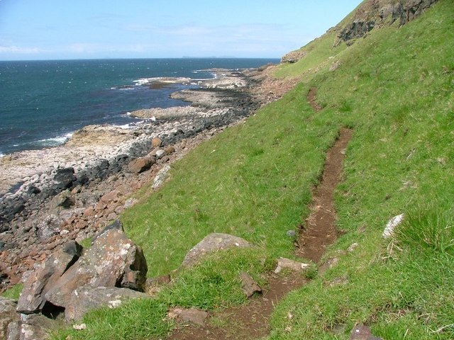
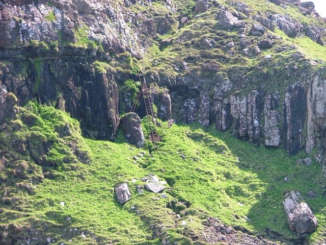
Cliff, Slope in Argyllshire

Scotland

Bidein na h-Iolaire

The Wilderness, Ardmeanach, Mull A burn rushes down its gully to the Sea of the Hebrides.
The Wilderness, Ardmeanach, Mull Credit: Alan Reid

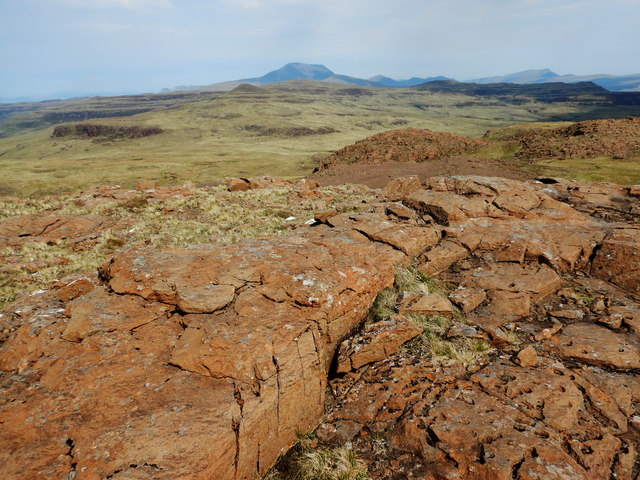
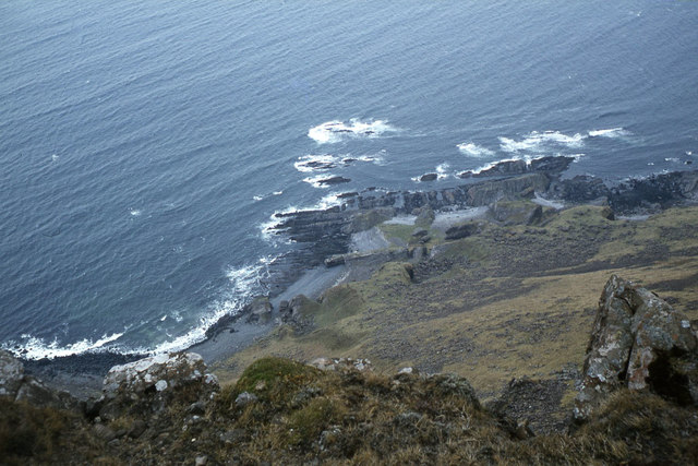
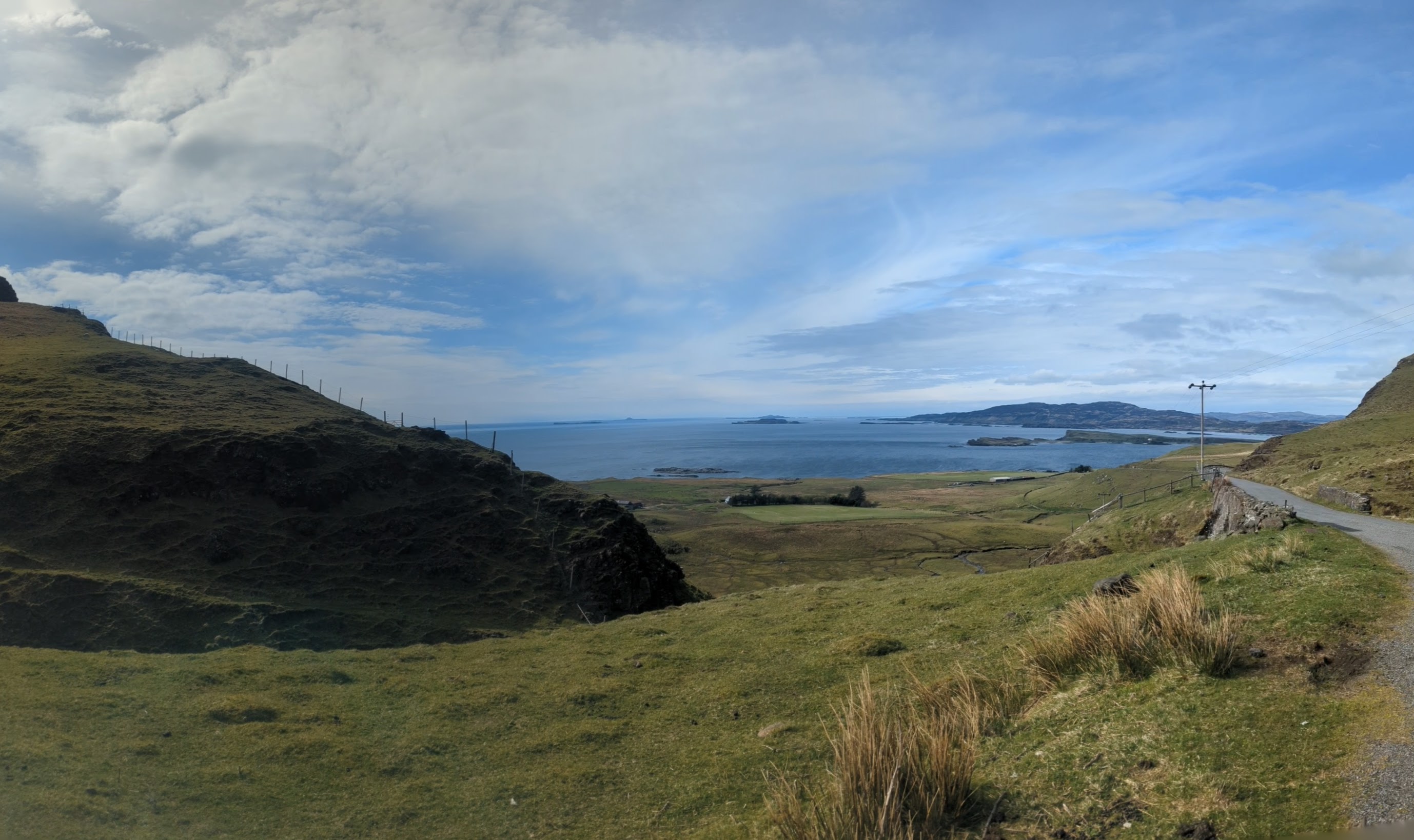
Bidein na h-Iolaire, also known as the Eagle's Peak, is a prominent cliff located in Argyllshire, Scotland. Situated in the region of Argyll and Bute, this steep slope is a popular natural landmark that attracts visitors from all over the world.

Rising dramatically from the surrounding landscape, Bidein na h-Iolaire stands at an impressive height of approximately 966 meters (3,169 feet). The cliff offers breathtaking views of the surrounding areas, including nearby lochs, mountains, and the vast Atlantic Ocean. The rugged and rocky terrain of the cliff is a testament to the geological history of the area, showcasing layers of ancient rock formations.

The name "Bidein na h-Iolaire" translates to "Peak of the Eagle" in Gaelic, which is inspired by the frequent sightings of majestic golden eagles in the vicinity. These birds of prey are often seen soaring above the cliff, adding to the natural beauty and allure of the location.

Access to Bidein na h-Iolaire can be challenging due to its remote location. Hikers and climbers who are experienced and well-prepared can embark on a challenging and rewarding journey to reach the summit. The ascent involves traversing rocky slopes and steep gradients, requiring physical fitness and proper equipment.

Bidein na h-Iolaire is not only a haven for outdoor enthusiasts, but also a site of cultural and historical significance. It has played a role in local folklore and legends, adding an element of mystique to its already captivating presence.

If you have any feedback on the listing, please let us know in the comments section below.

Bidein na h-Iolaire Images

Images are sourced within 2km of 56.376238/-6.2032652 or Grid Reference NM4028. Thanks to Geograph Open Source API. All images are credited.

The Wilderness, Ardmeanach, Mull A burn rushes down its gully to the Sea of the Hebrides.
The Wilderness, Ardmeanach, Mull
A burn rushes down its gully to the Sea of the Hebrides.
Footpath to the Fossil Tree Below the cliffs of the Fionn Aoineadh.
Footpath to the Fossil Tree
Below the cliffs of the Fionn Aoineadh.
Basalt Rock Formation Taken on the way to the fossilised tree. I am indebted to Keith Burns for this explanation of the fascinating geological processes involved here :

"On the beach, basalt columns radiate from a central point on the
shore near the fossil tree.  The columns are formed due to the cooling
effect of a standing tree on the lava flowing around the tree trunk.
The tree draws heat from the lava. When the lava shrinks, it forms
hexagonal shrinkage cracks which form columns whose axes are parallel to the
direction of heat flow.  So the hexagonal columns radiate from the tree
trunk which is drawing heat from the lava.

If lava is in a level slab losing heat to the air above it, it cools from
the top down and forms the more familiar vertical hexagonal columns (e.g.
Giant's Causeway, Staffa, Sampson's Ribs on Arthur's Seat in Edinburgh).

There must have been a forest that was engulfed by the slowly flowing lava."
Basalt Rock Formation
Taken on the way to the fossilised tree. I am indebted to Keith Burns for this explanation of the fascinating geological processes involved here : "On the beach, basalt columns radiate from a central point on the shore near the fossil tree. The columns are formed due to the cooling effect of a standing tree on the lava flowing around the tree trunk. The tree draws heat from the lava. When the lava shrinks, it forms hexagonal shrinkage cracks which form columns whose axes are parallel to the direction of heat flow. So the hexagonal columns radiate from the tree trunk which is drawing heat from the lava. If lava is in a level slab losing heat to the air above it, it cools from the top down and forms the more familiar vertical hexagonal columns (e.g. Giant's Causeway, Staffa, Sampson's Ribs on Arthur's Seat in Edinburgh). There must have been a forest that was engulfed by the slowly flowing lava."
MacCulloch's Tree A fifty million year old fossilised tree. Difficult to make out in the photo but it's in the centre to the left of the section of the rock face in shadow. It is 12m high and 1.2m wide.
MacCulloch's Tree
A fifty million year old fossilised tree. Difficult to make out in the photo but it's in the centre to the left of the section of the rock face in shadow. It is 12m high and 1.2m wide.
Footpath From Burg, Ladder The final section of the footpath from Burg includes this precarious ladder. The rusted remains of earlier ones accompany you on the descent.
Footpath From Burg, Ladder
The final section of the footpath from Burg includes this precarious ladder. The rusted remains of earlier ones accompany you on the descent.
Footpath below the Fionn Aoineadh A view in the opposite direction (to <a href="https://www.geograph.org.uk/photo/180876">NM4026 : Footpath to the Fossil Tree</a>) on the return from the Fossil Tree to Burg.
Footpath below the Fionn Aoineadh
A view in the opposite direction (to NM4026 : Footpath to the Fossil Tree) on the return from the Fossil Tree to Burg.
First Foot, Fossil Tree Probably the first visitors of 2008 to Macculloch's Tree, <span class="nowrap"><a title="http://www.scottishgeology.com/outandabout/classic_sites/locations/mull_macculloch.html" rel="nofollow ugc noopener" href="http://www.scottishgeology.com/outandabout/classic_sites/locations/mull_macculloch.html">Link</a><img style="margin-left:2px;" alt="External link" title="External link - shift click to open in new window" src="https://s1.geograph.org.uk/img/external.png" width="10" height="10"/></span> the figure and dogs give an idea of its size.
Also part of Ardmeanach SSSI, an important site for the sequence of lava flows which built the main cone of the Mull Volcano. <span class="nowrap"><a title="http://gateway.snh.gov.uk/portal/page?_pageid=53,910305,53_910314&_dad=portal&_schema=PORTAL&PA_CODE=74&NEW_WINDOW=false" rel="nofollow ugc noopener" href="http://gateway.snh.gov.uk/portal/page?_pageid=53,910305,53_910314&_dad=portal&_schema=PORTAL&PA_CODE=74&NEW_WINDOW=false">Link</a><img style="margin-left:2px;" alt="External link" title="External link - shift click to open in new window" src="https://s1.geograph.org.uk/img/external.png" width="10" height="10"/></span>
First Foot, Fossil Tree
Probably the first visitors of 2008 to Macculloch's Tree, LinkExternal link the figure and dogs give an idea of its size. Also part of Ardmeanach SSSI, an important site for the sequence of lava flows which built the main cone of the Mull Volcano. LinkExternal link
Burg, Bearraich, Isle of Mull (Ben More in background)
The Wilderness This is taken from the National Trust for Scotland's old boundary fence at Aird na h-iolaire at Burg.  The point in the distance are the caves at Uamh nan Calmon.
The Wilderness
This is taken from the National Trust for Scotland's old boundary fence at Aird na h-iolaire at Burg. The point in the distance are the caves at Uamh nan Calmon.
Bearraich View of the summit above the Wilderness.
Bearraich
View of the summit above the Wilderness.
Basalt formations, fans and columns at Burgh
Cliffs of Ardmeanach A telephoto view of the Cliffs of Ardmeanach on Mull seen from Dun I on Iona.
Cliffs of Ardmeanach
A telephoto view of the Cliffs of Ardmeanach on Mull seen from Dun I on Iona.
Basalt pavement on Creach Bheinn Each small cliff on the Ardmeanach peninsula represents a single lava flow from a single eruption. As the intervals between the deposition of each flow could be hundreds or thousands of years, the top of each flow would have had time to form a soil. When the next flow occurred, this formed a weak layer, and erosion now proceeds flow by flow, leaving the tops of the layers exposed and flat. Once you've found a suitable weakness for a route of ascent, each level surface forms an easy pavement to walk to the next step up (or down). Of all the peaks we climbed this day, this effect was most noticeable on the ones in the west of the area such as here on Creach Bheinn. The view looks back east over our route up Maol Mhèadhonach to Beinn na Srèine, then over Fionna Mhàm. Beyond lies Ben More, the only island Munro outside Skye and a constant part of our view all day.
Basalt pavement on Creach Bheinn
Each small cliff on the Ardmeanach peninsula represents a single lava flow from a single eruption. As the intervals between the deposition of each flow could be hundreds or thousands of years, the top of each flow would have had time to form a soil. When the next flow occurred, this formed a weak layer, and erosion now proceeds flow by flow, leaving the tops of the layers exposed and flat. Once you've found a suitable weakness for a route of ascent, each level surface forms an easy pavement to walk to the next step up (or down). Of all the peaks we climbed this day, this effect was most noticeable on the ones in the west of the area such as here on Creach Bheinn. The view looks back east over our route up Maol Mhèadhonach to Beinn na Srèine, then over Fionna Mhàm. Beyond lies Ben More, the only island Munro outside Skye and a constant part of our view all day.
The descent from Creach-Bheinn Whichever way you've come to Creach-Bheinn, from the east or the south, the last few metres of ascent and first of descent are going to be on the SE slope, avoiding crags in the other directions. To the north and west lie steep craggy slopes falling to "The Wilderness" an area only sensibly approached by sea. This southeast side is a mix of easy walking on basalt pavement, almost level scree or short grassy slopes on the thin soil. Ways can be found avoiding any scrambling on both the east and south slopes - in our case we are heading south to bag the final peak of Bearaich.
The descent from Creach-Bheinn
Whichever way you've come to Creach-Bheinn, from the east or the south, the last few metres of ascent and first of descent are going to be on the SE slope, avoiding crags in the other directions. To the north and west lie steep craggy slopes falling to "The Wilderness" an area only sensibly approached by sea. This southeast side is a mix of easy walking on basalt pavement, almost level scree or short grassy slopes on the thin soil. Ways can be found avoiding any scrambling on both the east and south slopes - in our case we are heading south to bag the final peak of Bearaich.
The south ridge of Creach-Bheinn Despite its craggy appearance on the OS map, the south ridge of Creach-Bheinn is an easy grassy slope with only a bit of zigzagging to avoid rocky outcrops. This view is from the low point where, on an anticlockwise outing round the Ardmeanach summits, one takes the decision on whether to include the final peak, Bearaich, in the walk, or bail out down Coire Buidhe to reach the track out. It was an easy decision when the cost of coming back to bag that last square was considered !
The south ridge of Creach-Bheinn
Despite its craggy appearance on the OS map, the south ridge of Creach-Bheinn is an easy grassy slope with only a bit of zigzagging to avoid rocky outcrops. This view is from the low point where, on an anticlockwise outing round the Ardmeanach summits, one takes the decision on whether to include the final peak, Bearaich, in the walk, or bail out down Coire Buidhe to reach the track out. It was an easy decision when the cost of coming back to bag that last square was considered !
Bearraich's summit plateau Apart from a small remnant of a lava flow sticking up, Bearraich's summit is a plateau formed by the level surface of the preceding lava flow. This view looks over that level, with its thin soil and short grass and sedge cover. There is a precipitous edge, though the cliffs are small (none of the lava flows which make up the whole of Ardmeanach were very thick) and there are grassy breaks through which a descent route can readily be found into Coire Buidhe with its deeper (and inevitably boggier) peat cover.

The view stretches to all the other summits of the Ardmeanach peninsula, and beyond to Ben More, constantly in view throughout the walk round these tops.
Bearraich's summit plateau
Apart from a small remnant of a lava flow sticking up, Bearraich's summit is a plateau formed by the level surface of the preceding lava flow. This view looks over that level, with its thin soil and short grass and sedge cover. There is a precipitous edge, though the cliffs are small (none of the lava flows which make up the whole of Ardmeanach were very thick) and there are grassy breaks through which a descent route can readily be found into Coire Buidhe with its deeper (and inevitably boggier) peat cover. The view stretches to all the other summits of the Ardmeanach peninsula, and beyond to Ben More, constantly in view throughout the walk round these tops.
Aoineadh Thapuill view over The Wilderness View west from southern end of the Aoineadh Thapuill cliffs and overlooking The Wilderness of Ardmeanach.  This point was reached via a walk along the atv track behind Tavool House and then a path skirting Creach Bheinn.
Aoineadh Thapuill view over The Wilderness
View west from southern end of the Aoineadh Thapuill cliffs and overlooking The Wilderness of Ardmeanach. This point was reached via a walk along the atv track behind Tavool House and then a path skirting Creach Bheinn.
The Wilderness, Ardmeanach
Show me another place!

Bidein na h-Iolaire is located at Grid Ref: NM4028 (Lat: 56.376238, Lng: -6.2032652)

Unitary Authority: Argyll and Bute

Police Authority: Argyll and West Dunbartonshire

What 3 Words

///matchbox.sting.suspend. Near Fionnphort, Argyll & Bute

Related Wikis

Knockan

Knockan (Scottish Gaelic: An Cnocan) is a township of six crofts in the community of Ardtun, in the south of the Isle of Mull off the west coast of Scotland...

Ardtun

Ardtun (Scottish Gaelic: Àird Tunna) is a settlement on the Isle of Mull, in Argyll and Bute, Scotland. Ardtun is within the parish of Kilfinichen and...

Ardmeanach

Ardmeanach (Scottish Gaelic: Ard Meanach) is a peninsula on the Isle of Mull. It is the middle one out of three westward-facing peninsulas on the island...

Camas Tuath

Camas Tuath (Scottish Gaelic: north bay) is an inlet bay on the Ross of Mull. The bay has two small tidal islands and two Quarrymans' Cottages which the...

Have you been to Bidein na h-Iolaire?

Leave your review of Bidein na h-Iolaire below (or comments, questions and feedback).