Bearraidh na Creige Chaise

Cliff, Slope in Inverness-shire

Scotland

Bearraidh na Creige Chaise

An Campar Hill at the north-western end of Hirta in the St Kilda archipelago.
An Campar Credit: David Dixon

Bearraidh na Creige Chaise, also known as the Cliff of Slope, is a prominent geographical feature located in Inverness-shire, Scotland. Situated in the northern part of the country, this natural formation is a significant landmark in the region.

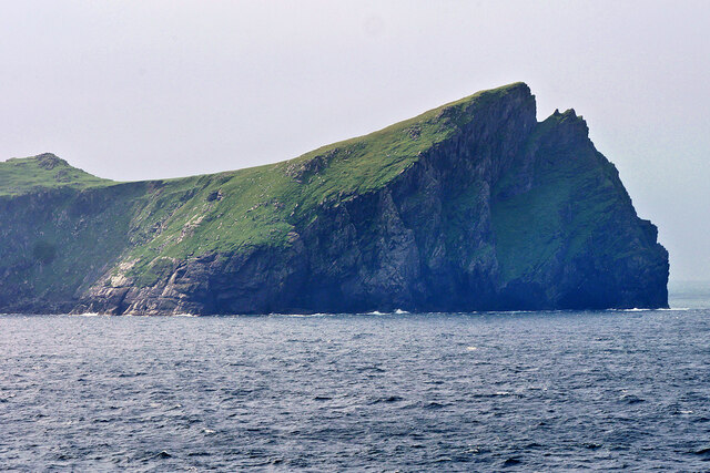
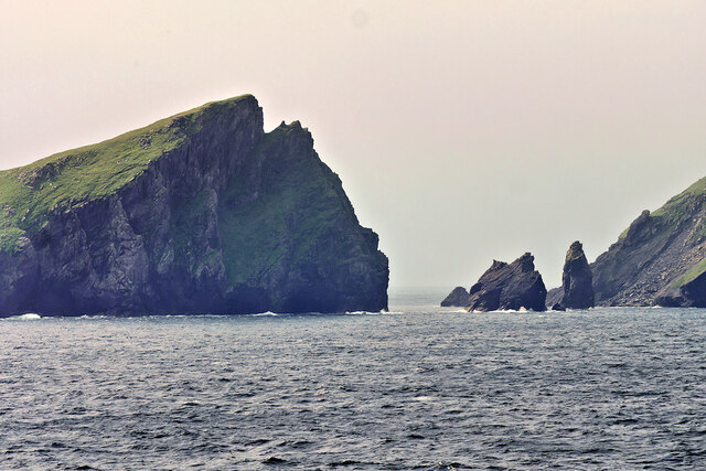
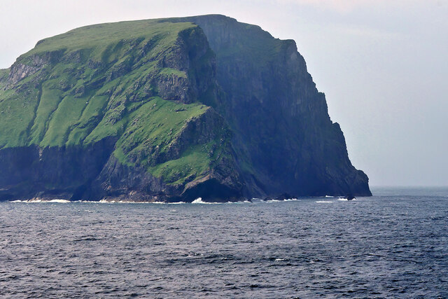
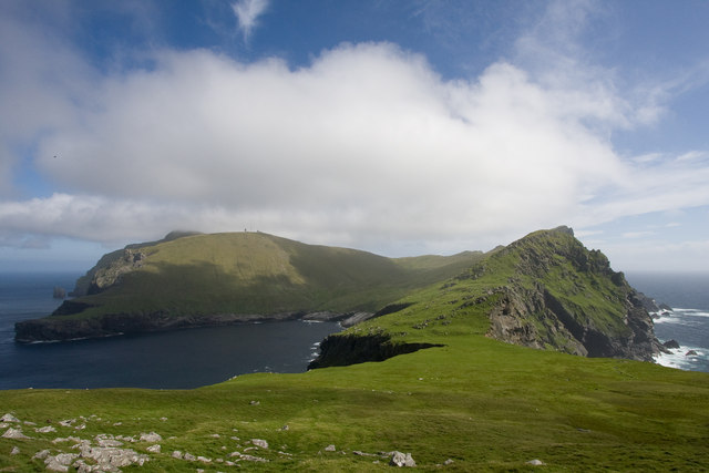
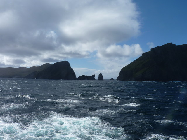
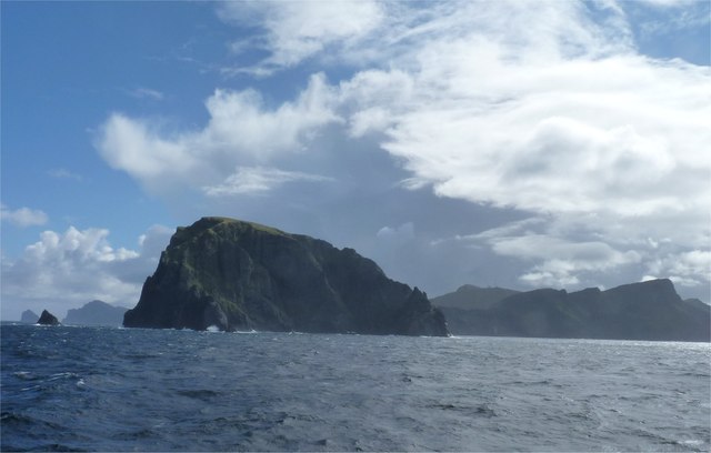
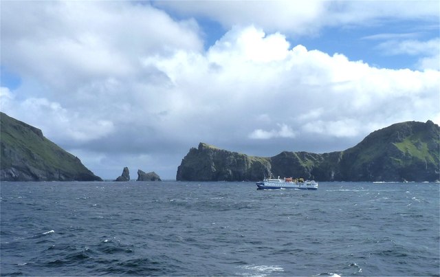
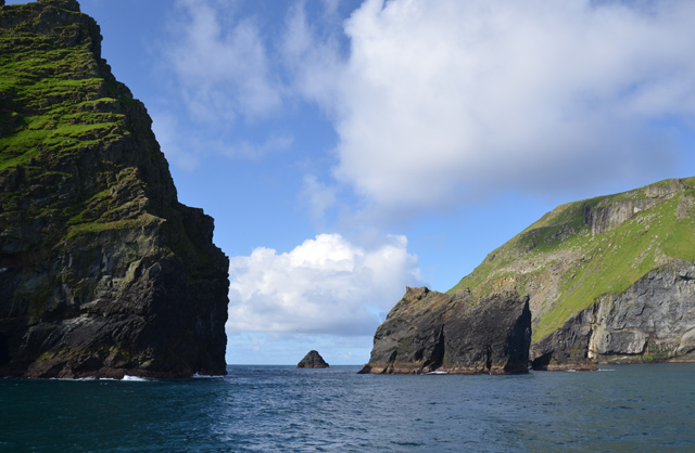
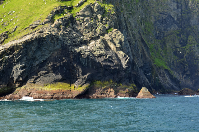
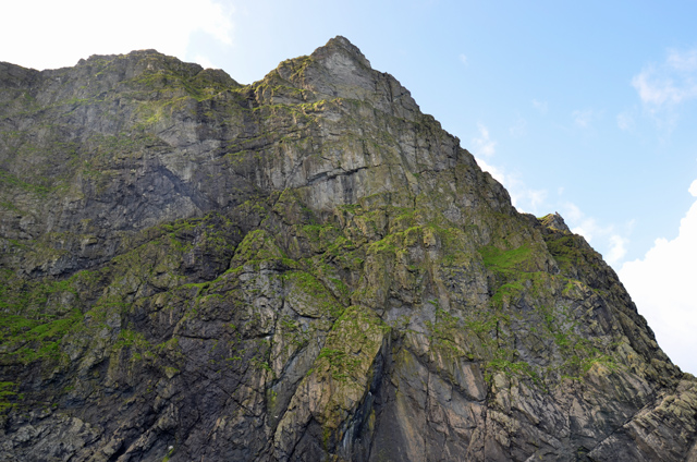
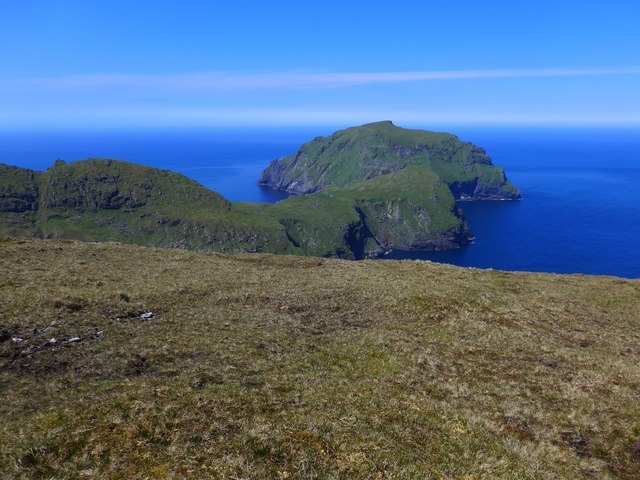
Bearraidh na Creige Chaise is characterized by its steep and rugged cliffs, which extend for several kilometers along the coastline. These cliffs offer breathtaking views of the surrounding area and the nearby waters of the North Sea. The height of the cliffs varies, with some sections reaching up to 100 meters, creating an awe-inspiring sight for visitors.

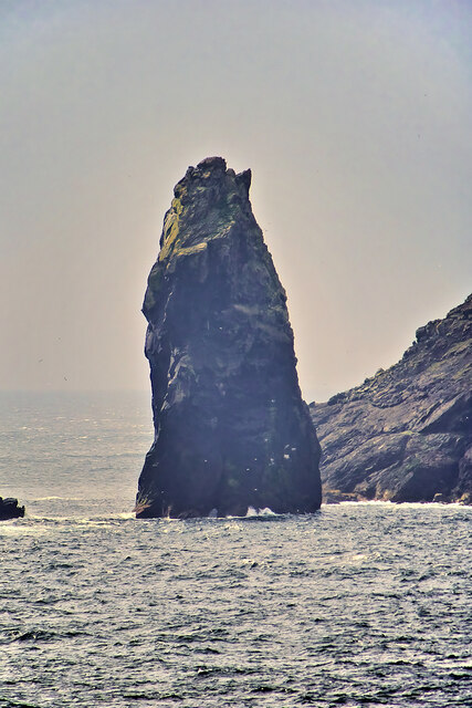
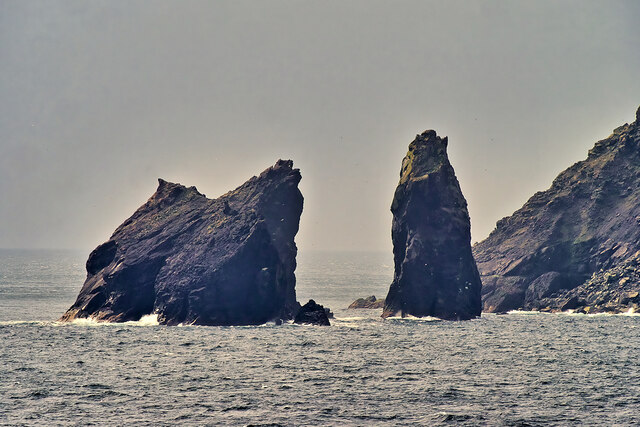
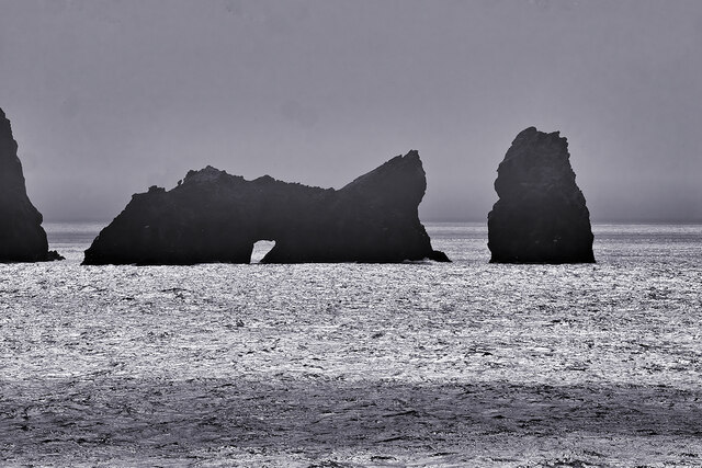
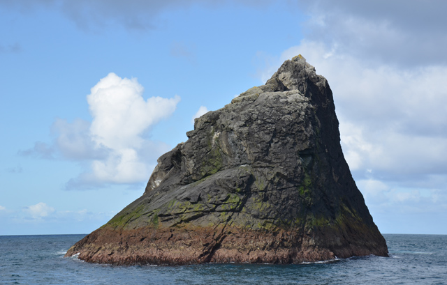
The geological composition of Bearraidh na Creige Chaise consists mainly of sedimentary rocks, including sandstone and limestone, which have been shaped and eroded over millions of years by the forces of nature. This erosion has resulted in the formation of caves, arches, and stacks, adding to the beauty and intrigue of the area.

The location of Bearraidh na Creige Chaise also makes it a popular spot for wildlife enthusiasts. The cliffs provide nesting sites for various seabirds, including puffins, fulmars, and guillemots. Additionally, the surrounding waters are home to a diverse range of marine life, making it an ideal destination for birdwatching and marine wildlife spotting.

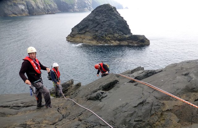
Access to Bearraidh na Creige Chaise is relatively easy, with well-maintained paths and viewpoints that allow visitors to explore and appreciate the natural wonders of this stunning cliff. However, caution is advised due to the steepness and potential hazards associated with the rugged terrain.

Overall, Bearraidh na Creige Chaise is a must-visit destination for nature lovers, offering a unique combination of dramatic cliffs, stunning views, and abundant wildlife.

If you have any feedback on the listing, please let us know in the comments section below.

Bearraidh na Creige Chaise Images

Images are sourced within 2km of 57.831071/-8.6322511 or Grid Reference NA0601. Thanks to Geograph Open Source API. All images are credited.

An Campar Hill at the north-western end of Hirta in the St Kilda archipelago.
An Campar
Hill at the north-western end of Hirta in the St Kilda archipelago.
St Kilda, Soay Strait The islands of Soay (Shoaigh) and Hirta (Hiort) in the St Kilda archipelago are separated by the narrow Sound of Soay which is only about 500 metres wide. Two sea stacks, Stac Shoaigh (Soay Stac) (200 ft), and Stac Biorach, (240 ft), lie between the two islands.
St Kilda, Soay Strait
The islands of Soay (Shoaigh) and Hirta (Hiort) in the St Kilda archipelago are separated by the narrow Sound of Soay which is only about 500 metres wide. Two sea stacks, Stac Shoaigh (Soay Stac) (200 ft), and Stac Biorach, (240 ft), lie between the two islands.
Stac Biorach, St Kilda Stac Biorach (Scottish Gaelic meaning "the pointed stack") is a sea stack, 73 metres tall, situated in the Sound of Soay, between the islands of Hirta and Soay in the St Kilda archipelago.
Stac Biorach, St Kilda
Stac Biorach (Scottish Gaelic meaning "the pointed stack") is a sea stack, 73 metres tall, situated in the Sound of Soay, between the islands of Hirta and Soay in the St Kilda archipelago.
Sea stacks between Soay and Hirta The islands of Soay (Shoaigh) and Hirta (Hiort) in the St Kilda archipelago are separated by the narrow Sound of Soay which is only about 500 metres wide. Two sea stacks, Stac Shoaigh (Soay Stac) (200 ft), and Stac Biorach, (240 ft), lie between the two islands.
Sea stacks between Soay and Hirta
The islands of Soay (Shoaigh) and Hirta (Hiort) in the St Kilda archipelago are separated by the narrow Sound of Soay which is only about 500 metres wide. Two sea stacks, Stac Shoaigh (Soay Stac) (200 ft), and Stac Biorach, (240 ft), lie between the two islands.
Soay, St Kilda Soay (Scottish Gaelic: Soaigh) is an uninhabited islet in the St Kilda archipelago; it is the westernmost point in the United Kingdom. The name derives from Old Norse Seyðoy, meaning "Island of Sheep". The island is home to a primitive breed of sheep, Soay sheep <span class="nowrap"><a title="https://en.wikipedia.org/wiki/Soay_sheep" rel="nofollow ugc noopener" href="https://en.wikipedia.org/wiki/Soay_sheep">Link</a><img style="margin-left:2px;" alt="External link" title="External link - shift click to open in new window" src="https://s1.geograph.org.uk/img/external.png" width="10" height="10"/></span> .
Soay, St Kilda
Soay (Scottish Gaelic: Soaigh) is an uninhabited islet in the St Kilda archipelago; it is the westernmost point in the United Kingdom. The name derives from Old Norse Seyðoy, meaning "Island of Sheep". The island is home to a primitive breed of sheep, Soay sheep LinkExternal link .
Stacs Shoaigh and Biorach, St Kilda Archipelago The islands of Soay (Shoaigh) and Hirta (Hiort) in the St Kilda archipelago are separated by the narrow Sound of Soay which is only about 500 metres wide. Two sea stacks, Stac Shoaigh (Soay Stac) (200 ft), and Stac Biorach, (240 ft), lie between the two islands.

Stac Shoaigh has an arch at its base.
Stacs Shoaigh and Biorach, St Kilda Archipelago
The islands of Soay (Shoaigh) and Hirta (Hiort) in the St Kilda archipelago are separated by the narrow Sound of Soay which is only about 500 metres wide. Two sea stacks, Stac Shoaigh (Soay Stac) (200 ft), and Stac Biorach, (240 ft), lie between the two islands. Stac Shoaigh has an arch at its base.
Cambir on St Kilda The view south from the tip of The Cambir (216 m) with Mullach Mor (361 m) on the left and Mullach Bi (358 m) on the right.
Cambir on St Kilda
The view south from the tip of The Cambir (216 m) with Mullach Mor (361 m) on the left and Mullach Bi (358 m) on the right.
Preparing To Leave Soay Pete Ellis doing the calm lead climbing assisted by Dave Tyson and Alan Whatley. Once the slippy bits were out of the way it was just a rocky scramble then out onto a grassy ledge before upward and onward to the top of Soay. This pictures shows our two abseil ropes with a view towards Stac Dona.
Preparing To Leave Soay
Pete Ellis doing the calm lead climbing assisted by Dave Tyson and Alan Whatley. Once the slippy bits were out of the way it was just a rocky scramble then out onto a grassy ledge before upward and onward to the top of Soay. This pictures shows our two abseil ropes with a view towards Stac Dona.
Stac Shoaigh and Stac Biorach In the Sound of Soay between the islands of Soay and Hirta.
Stac Shoaigh and Stac Biorach
In the Sound of Soay between the islands of Soay and Hirta.
The island of Soay The sea stack to the left is Am Plastair and the hills of Hirta are in the background.
The island of Soay
The sea stack to the left is Am Plastair and the hills of Hirta are in the background.
Crossing the Sound of Soay A cruise ship with the islands of Soay to the left and Hirta to the right in the background.
Crossing the Sound of Soay
A cruise ship with the islands of Soay to the left and Hirta to the right in the background.
Channel between Hirta and Soay With the bulky Stac Shoaigh to the right of the visible gap.
Channel between Hirta and Soay
With the bulky Stac Shoaigh to the right of the visible gap.
Geodha Ruadh The northern extremity of Soay.
Geodha Ruadh
The northern extremity of Soay.
Cliffs on Soay The cliffs rise around 300m out of the sea.
Cliffs on Soay
The cliffs rise around 300m out of the sea.
Am Plastair A sea stack to the north of Soay. It is around 45m tall.
Am Plastair
A sea stack to the north of Soay. It is around 45m tall.
View to An Campar and Soay On Hirta, St Kilda in perfect weather.
View to An Campar and Soay
On Hirta, St Kilda in perfect weather.
Poll a' Choire
Poll a' Choire
Stac Shoaigh and Stac Biorach bridge the gap to Soay
Show me another place!

Bearraidh na Creige Chaise is located at Grid Ref: NA0601 (Lat: 57.831071, Lng: -8.6322511)

Unitary Authority: Na h-Eileanan an Iar

Police Authority: Highlands and Islands

What 3 Words

///believer.shorthand.yelled. Near Balivanich, Na h-Eileanan Siar

Related Wikis

Soay, St Kilda

Soay (Scottish Gaelic: Soaigh) is an uninhabited islet in the St Kilda archipelago, Scotland. The name is from Old Norse Seyðoy, meaning 'island of sheep...

Stac Biorach

Stac Biorach (Scottish Gaelic: "the pointed stack") is a sea stack, 73 metres tall, situated between Hirta and Soay (in the "Sound of Soay") in the St...

St Kilda, Scotland

St Kilda (Scottish Gaelic: Hiort) is an isolated archipelago situated 64 kilometres (40 mi) west-northwest of North Uist in the North Atlantic Ocean. It...

Hirta

Hirta (Scottish Gaelic: Hiort) is the largest island in the St Kilda archipelago, on the western edge of Scotland. The names Hiort (in Scottish Gaelic...

Nearby Amenities

Located within 500m of 57.831071,-8.6322511
Cnoc Glas
Corbett: no
Ele: 376
Graham: no
Marilyn: yes
Munro: no
Natural: peak
Prominence: 376
Source: npe
Wikidata: Q24677486
Lat/Long: 57.8302777/-8.6374945
Ele: 340
Natural: peak
Source: npe
Lat/Long: 57.8291082/-8.6319221
Natural: rock
Seamark Type: rock
Lat/Long: 57.8342362/-8.6273149
Natural: rock
Seamark Type: rock
Lat/Long: 57.8348923/-8.6282885
Natural: rock
Seamark Type: rock
Lat/Long: 57.8335933/-8.6305438
Natural: rock
Seamark Type: rock
Lat/Long: 57.8335211/-8.629829
Natural: rock
Seamark Type: rock
Lat/Long: 57.8333505/-8.6305685
Natural: rock
Seamark Type: rock
Lat/Long: 57.8342886/-8.6320199
The data included in this document is from www.openstreetmap.org. The data is made available under ODbL.

Have you been to Bearraidh na Creige Chaise?

Leave your review of Bearraidh na Creige Chaise below (or comments, questions and feedback).