Pen y Gloyn

Landscape Feature in Cardiganshire

Wales

Pen y Gloyn

Tollhouse, Aberaeron North Turnpike The gate-post on the opposite side of the road bore an Ordnance Survey benchmark:

The mark was used on the Warrington to Pembroke Docks line of the First Primary Levelling of England & Wales in 1851-1852. It was levelled with a height of 61.650' above OD (Liverpool). Description: 664. Mark on West post of Aberaeron North Turnpike-gate ; 1.93 ft. above surface. Page 534 of the abstract: <span class="nowrap"><a title="https://www.bench-marks.org.uk/abstract/ew1gl/1GLA_534.png" rel="nofollow ugc noopener" href="https://www.bench-marks.org.uk/abstract/ew1gl/1GLA_534.png">Link</a><img style="margin-left:2px;" alt="External link" title="External link - shift click to open in new window" src="https://s1.geograph.org.uk/img/external.png" width="10" height="10"/></span>

From the West: <a href="https://www.geograph.org.uk/photo/7056118">SN4663 : Tollhouse, Aberaeron North Turnpike</a>
Tollhouse, Aberaeron North Turnpike Credit: N Scott

Pen y Gloyn is a prominent landscape feature located in Cardiganshire, Wales. It is situated in the scenic countryside, offering breathtaking views of the surrounding area. The name "Pen y Gloyn" translates to "Hill of the Gull" in English.

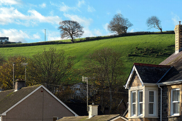
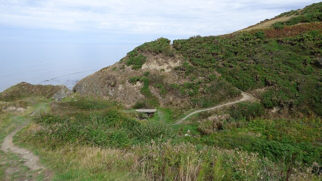
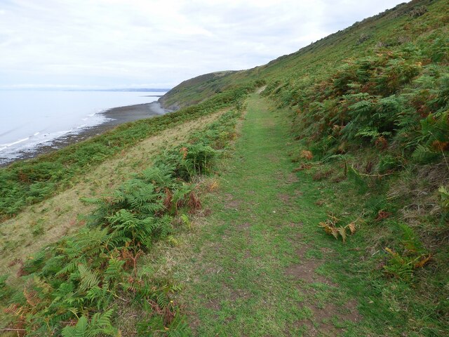
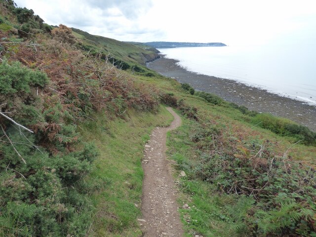
This landscape feature is a hill that rises to an elevation of approximately 350 meters (1,150 feet) above sea level. It is characterized by its rounded shape and gentle slopes, making it an easily recognizable landmark in the region. The hill is covered with lush green vegetation, including grasses and scattered trees, creating a picturesque and tranquil setting.

Pen y Gloyn is known for its panoramic views, making it a popular destination for hikers, nature enthusiasts, and photographers. From the summit, visitors can enjoy sweeping vistas of the rolling hills, valleys, and distant mountains that stretch as far as the eye can see.

The hill is also home to a diverse range of wildlife, including various bird species, small mammals, and insects. It provides a natural habitat for these creatures, contributing to the biodiversity of the area.

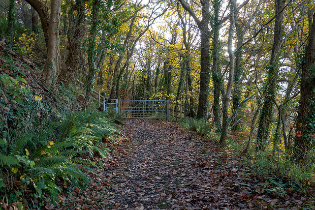
Access to Pen y Gloyn is relatively easy, with several footpaths and trails leading to the top. These paths offer visitors the opportunity to explore the hill's natural beauty up close and appreciate the tranquility of the surroundings.

Overall, Pen y Gloyn is a captivating landscape feature in Cardiganshire, offering stunning views, a rich biodiversity, and a serene environment for all who visit.

If you have any feedback on the listing, please let us know in the comments section below.
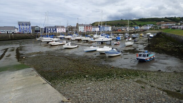
Pen y Gloyn Images

Images are sourced within 2km of 52.238929/-4.2729552 or Grid Reference SN4462. Thanks to Geograph Open Source API. All images are credited.
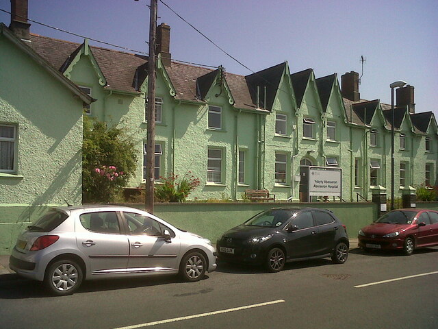
Tollhouse, Aberaeron North Turnpike The gate-post on the opposite side of the road bore an Ordnance Survey benchmark:

The mark was used on the Warrington to Pembroke Docks line of the First Primary Levelling of England & Wales in 1851-1852. It was levelled with a height of 61.650' above OD (Liverpool). Description: 664. Mark on West post of Aberaeron North Turnpike-gate ; 1.93 ft. above surface. Page 534 of the abstract: <span class="nowrap"><a title="https://www.bench-marks.org.uk/abstract/ew1gl/1GLA_534.png" rel="nofollow ugc noopener" href="https://www.bench-marks.org.uk/abstract/ew1gl/1GLA_534.png">Link</a><img style="margin-left:2px;" alt="External link" title="External link - shift click to open in new window" src="https://s1.geograph.org.uk/img/external.png" width="10" height="10"/></span>

From the West: <a href="https://www.geograph.org.uk/photo/7056118">SN4663 : Tollhouse, Aberaeron North Turnpike</a>
Tollhouse, Aberaeron North Turnpike
The gate-post on the opposite side of the road bore an Ordnance Survey benchmark: The mark was used on the Warrington to Pembroke Docks line of the First Primary Levelling of England & Wales in 1851-1852. It was levelled with a height of 61.650' above OD (Liverpool). Description: 664. Mark on West post of Aberaeron North Turnpike-gate ; 1.93 ft. above surface. Page 534 of the abstract: LinkExternal link From the West: SN4663 : Tollhouse, Aberaeron North Turnpike
Tollhouse, Aberaeron North Turnpike The gate-post on the opposite side of the road bore an Ordnance Survey benchmark:

The mark was used on the Warrington to Pembroke Docks line of the First Primary Levelling of England & Wales in 1851-1852. It was levelled with a height of 61.650' above OD (Liverpool). Description: 664. Mark on West post of Aberaeron North Turnpike-gate ; 1.93 ft. above surface. Page 534 of the abstract: <span class="nowrap"><a title="https://www.bench-marks.org.uk/abstract/ew1gl/1GLA_534.png" rel="nofollow ugc noopener" href="https://www.bench-marks.org.uk/abstract/ew1gl/1GLA_534.png">Link</a><img style="margin-left:2px;" alt="External link" title="External link - shift click to open in new window" src="https://s1.geograph.org.uk/img/external.png" width="10" height="10"/></span>

From the North-east: <a href="https://www.geograph.org.uk/photo/7056115">SN4663 : Tollhouse, Aberaeron North Turnpike</a>
Tollhouse, Aberaeron North Turnpike
The gate-post on the opposite side of the road bore an Ordnance Survey benchmark: The mark was used on the Warrington to Pembroke Docks line of the First Primary Levelling of England & Wales in 1851-1852. It was levelled with a height of 61.650' above OD (Liverpool). Description: 664. Mark on West post of Aberaeron North Turnpike-gate ; 1.93 ft. above surface. Page 534 of the abstract: LinkExternal link From the North-east: SN4663 : Tollhouse, Aberaeron North Turnpike
Tollhouse, Aberaeron West Turnpike The house to the West (right) of the tollhouse bore an Ordnance Survey benchmark:

The mark was used on the Warrington to Pembroke Docks line of the First Primary Levelling of England & Wales in 1851-1852. It was levelled with a height of 79.263' above OD (Liverpool). Description: 666. Mark on front of John Jones's house, at West side of Aberaeron West Turnpike-gate ; 0.87 ft. above surface. Page 535 of the abstract: <span class="nowrap"><a title="https://www.bench-marks.org.uk/abstract/ew1gl/1GLA_535.png" rel="nofollow ugc noopener" href="https://www.bench-marks.org.uk/abstract/ew1gl/1GLA_535.png">Link</a><img style="margin-left:2px;" alt="External link" title="External link - shift click to open in new window" src="https://s1.geograph.org.uk/img/external.png" width="10" height="10"/></span>

From the West: <a href="https://www.geograph.org.uk/photo/7056132">SN4562 : Tollhouse, Aberaeron West Turnpike</a>
Tollhouse, Aberaeron West Turnpike
The house to the West (right) of the tollhouse bore an Ordnance Survey benchmark: The mark was used on the Warrington to Pembroke Docks line of the First Primary Levelling of England & Wales in 1851-1852. It was levelled with a height of 79.263' above OD (Liverpool). Description: 666. Mark on front of John Jones's house, at West side of Aberaeron West Turnpike-gate ; 0.87 ft. above surface. Page 535 of the abstract: LinkExternal link From the West: SN4562 : Tollhouse, Aberaeron West Turnpike
Tollhouse, Aberaeron West Turnpike The house to the West (right) of the tollhouse bore an Ordnance Survey benchmark:

The mark was used on the Warrington to Pembroke Docks line of the First Primary Levelling of England & Wales in 1851-1852. It was levelled with a height of 79.263' above OD (Liverpool). Description: 666. Mark on front of John Jones's house, at West side of Aberaeron West Turnpike-gate ; 0.87 ft. above surface. Page 535 of the abstract: <span class="nowrap"><a title="https://www.bench-marks.org.uk/abstract/ew1gl/1GLA_535.png" rel="nofollow ugc noopener" href="https://www.bench-marks.org.uk/abstract/ew1gl/1GLA_535.png">Link</a><img style="margin-left:2px;" alt="External link" title="External link - shift click to open in new window" src="https://s1.geograph.org.uk/img/external.png" width="10" height="10"/></span>

From the North: <a href="https://www.geograph.org.uk/photo/7056127">SN4562 : Tollhouse, Aberaeron West Turnpike</a>
Tollhouse, Aberaeron West Turnpike
The house to the West (right) of the tollhouse bore an Ordnance Survey benchmark: The mark was used on the Warrington to Pembroke Docks line of the First Primary Levelling of England & Wales in 1851-1852. It was levelled with a height of 79.263' above OD (Liverpool). Description: 666. Mark on front of John Jones's house, at West side of Aberaeron West Turnpike-gate ; 0.87 ft. above surface. Page 535 of the abstract: LinkExternal link From the North: SN4562 : Tollhouse, Aberaeron West Turnpike
Afon Aeron Footbridge View from the road bridge
Afon Aeron Footbridge
View from the road bridge
New Sea Defences The limestone barrier being created in 2009
New Sea Defences
The limestone barrier being created in 2009
Sea defences at Aberaeron Boulders and groynes protect the promenade
Sea defences at Aberaeron
Boulders and groynes protect the promenade
Start of the Aberaeron to Lampeter Trail Leading out of Aberaeron.
Start of the Aberaeron to Lampeter Trail
Leading out of Aberaeron.
Aberaeron Integrated Care Centre Beside Afon Aeron and built on the site of the Aberaeron railway branch terminus.
Aberaeron Integrated Care Centre
Beside Afon Aeron and built on the site of the Aberaeron railway branch terminus.
The sun shines on Aberaeron! Sunlit houses in South Street.
The sun shines on Aberaeron!
Sunlit houses in South Street.
Panteg fields On the edge of Aberaeron.
Panteg fields
On the edge of Aberaeron.
The bridge over the Aeron At Aberaeron on a fine winter's day.
The bridge over the Aeron
At Aberaeron on a fine winter's day.
Aberaeron Union Workhouse/Cottage Hospital Aberayron Poor Law Union was the first in Cardiganshire to open a workhouse, which was built in 1839-40, by William Green, to designs of George Wilkinson.  It was converted for use as a hospital for injured soldiers in 1914 and became a cottage hospital in 1930.  The hospital closed in 2019, when the new Integrated Care Centre opened at the Minaeron site, Vicarage Hill.  The building was demolished in 2021.

Side: <a href="https://www.geograph.org.uk/photo/7358085">SN4662 : Aberaeron Union Workhouse/Cottage Hospital</a>
Aberaeron Union Workhouse/Cottage Hospital
Aberayron Poor Law Union was the first in Cardiganshire to open a workhouse, which was built in 1839-40, by William Green, to designs of George Wilkinson. It was converted for use as a hospital for injured soldiers in 1914 and became a cottage hospital in 1930. The hospital closed in 2019, when the new Integrated Care Centre opened at the Minaeron site, Vicarage Hill. The building was demolished in 2021. Side: SN4662 : Aberaeron Union Workhouse/Cottage Hospital
Aberaeron Union Workhouse/Cottage Hospital This face of the building bore OSBM flush bracket S0449 at the East (left) angle:

The bracket was used on the Aberystwyth to Lampeter secondary line of the Second Geodetic Levelling of England & Wales in 1942. It was levelled with a height of 43.956' above OD (Newlyn). Description: E angle of workhouse, Aberayron. Abstract A 483: <span class="nowrap"><a title="http://discovery.nationalarchives.gov.uk/details/r/C11178827" rel="nofollow ugc noopener" href="http://discovery.nationalarchives.gov.uk/details/r/C11178827">Link</a><img style="margin-left:2px;" alt="External link" title="External link - shift click to open in new window" src="https://s1.geograph.org.uk/img/external.png" width="10" height="10"/></span> [OS 54/148]

The bracket, which had been obscured by rendering, was replaced by G2986 on the Midland Bank for the Third Geodetic Levelling in 1956.

Front: <a href="https://www.geograph.org.uk/photo/7358078">SN4662 : Aberaeron Union Workhouse/Cottage Hospital</a>
Aberaeron Union Workhouse/Cottage Hospital
This face of the building bore OSBM flush bracket S0449 at the East (left) angle: The bracket was used on the Aberystwyth to Lampeter secondary line of the Second Geodetic Levelling of England & Wales in 1942. It was levelled with a height of 43.956' above OD (Newlyn). Description: E angle of workhouse, Aberayron. Abstract A 483: LinkExternal link [OS 54/148] The bracket, which had been obscured by rendering, was replaced by G2986 on the Midland Bank for the Third Geodetic Levelling in 1956. Front: SN4662 : Aberaeron Union Workhouse/Cottage Hospital
Ceredigion Coast path Bridge across the Ceri Brook. This bridge was erected sometime after 2004 <a href="https://www.geograph.org.uk/photo/499270">SN4361 : Cwm Cilfforch taken from Cilcert side</a>
Ceredigion Coast path
Bridge across the Ceri Brook. This bridge was erected sometime after 2004 SN4361 : Cwm Cilfforch taken from Cilcert side
Ceredigion Coastal Path near Cilfforch
Ceredigion Coast Path Well trodden along this length.
Ceredigion Coast Path
Well trodden along this length.
Low tide at Aberaeron
Show me another place!

Pen y Gloyn is located at Grid Ref: SN4462 (Lat: 52.238929, Lng: -4.2729552)

Unitary Authority: Ceredigion

Police Authority: Dyfed Powys

What 3 Words

///eruptions.orange.bulge. Near Aberaeron, Ceredigion

Related Wikis

Ceredigion District Council

Ceredigion District Council was one of six district-level authorities in the county of Dyfed, Wales, from 1974 until 1996. The district had an identical...
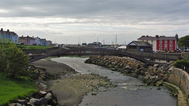
River Aeron

The River Aeron (Welsh: Afon Aeron) is a small river in Ceredigion, Wales, that flows into Cardigan Bay at Aberaeron. It is also referred to on some older...

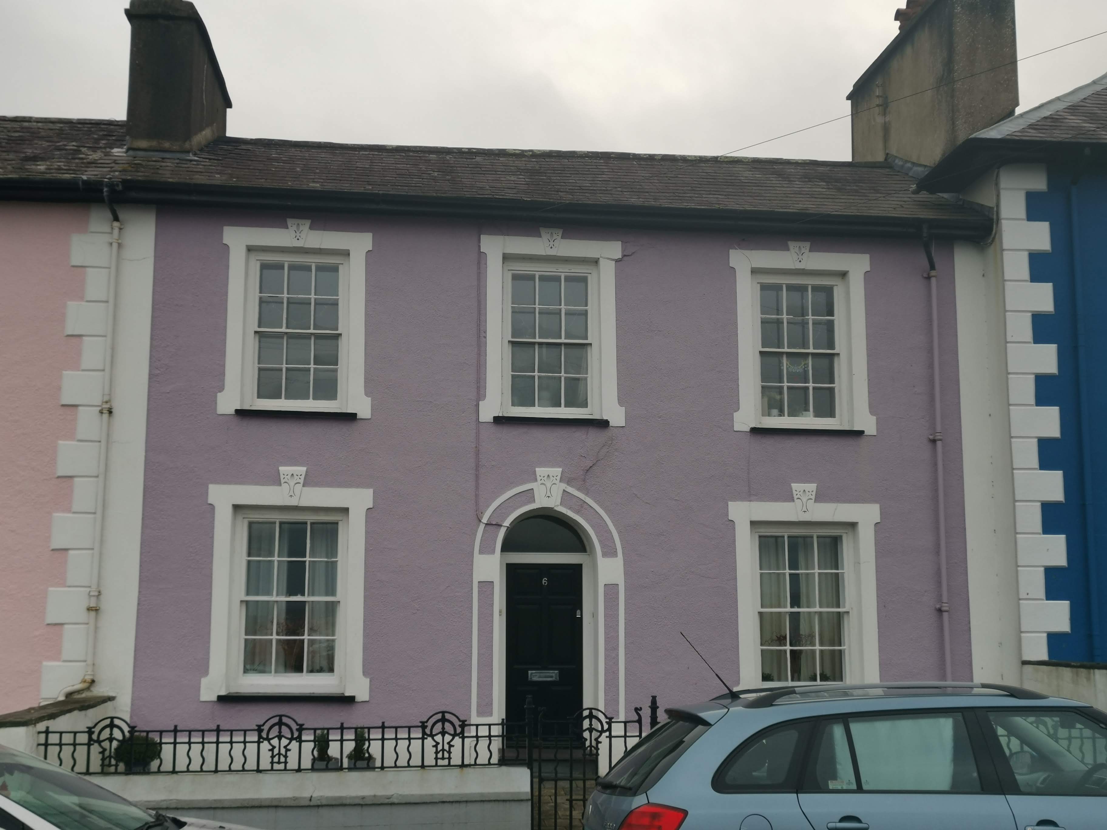
Portland Place, Aberaeron

Portland Place, in the centre of Aberaeron, Ceredigion, Wales is a terrace of mid-19th century townhouses. The town of Aberaeron was developed around 1810...
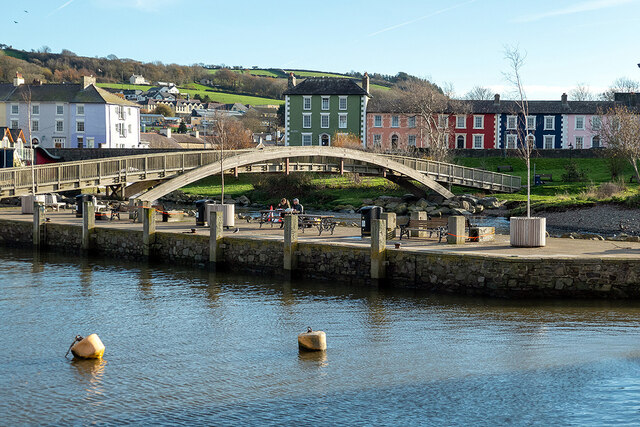
Aberaeron

Aberaeron (Welsh pronunciation: [abɛˈrei̯rɔn]), previously anglicised as Aberayron, is a town, community and electoral ward in Ceredigion, Wales. Located...

Nearby Amenities

Located within 500m of 52.238929,-4.2729552
Source: PGS
Lat/Long: 52.2413926/-4.2669513
Created By: dmgroom_coastlines
Source: PGS
Lat/Long: 52.240796/-4.267786
Created By: dmgroom_coastlines
Source: PGS
Lat/Long: 52.240149/-4.268395
Created By: dmgroom_coastlines
Source: PGS
Lat/Long: 52.239889/-4.268805
Created By: dmgroom_coastlines
Source: PGS
Lat/Long: 52.239628/-4.269215
Created By: dmgroom_coastlines
Source: PGS
Lat/Long: 52.23937/-4.269415
Created By: dmgroom_coastlines
Source: PGS
Lat/Long: 52.2393666/-4.2703245
Created By: dmgroom_coastlines
Source: PGS
Lat/Long: 52.2394011/-4.2712126
Created By: dmgroom_coastlines
Source: PGS
Lat/Long: 52.2393108/-4.27275
Created By: dmgroom_coastlines
Source: PGS
Lat/Long: 52.2388863/-4.2731875
Created By: dmgroom_coastlines
Source: PGS
Lat/Long: 52.238298/-4.273768
Created By: dmgroom_coastlines
Source: PGS
Lat/Long: 52.238037/-4.274178
Created By: dmgroom_coastlines
Source: PGS
Lat/Long: 52.237779/-4.274378
Created By: dmgroom_coastlines
Source: PGS
Lat/Long: 52.2376218/-4.2751462
Created By: dmgroom_coastlines
Source: PGS
Lat/Long: 52.23738/-4.275619
Created By: dmgroom_coastlines
Source: PGS
Lat/Long: 52.237244/-4.2762773
Created By: dmgroom_coastlines
Source: PGS
Lat/Long: 52.2368444/-4.2767549
Created By: dmgroom_coastlines
Source: PGS
Lat/Long: 52.2364998/-4.2770648
Created By: dmgroom_coastlines
Source: PGS
Lat/Long: 52.236333/-4.277676
Created By: dmgroom_coastlines
Source: PGS
Lat/Long: 52.236073/-4.278086
Parking
Parking: layby
Lat/Long: 52.2383453/-4.2708398
Barrier: kissing_gate
Lat/Long: 52.2371934/-4.2750582
Barrier: stile
Lat/Long: 52.2384657/-4.2725407
Barrier: stile
Lat/Long: 52.2383034/-4.271051
Direction: SE
Generator Method: photovoltaic
Generator Output Electricity: yes
Generator Solar Modules: 8
Generator Source: solar
Generator Type: solar_photovoltaic_panel
Location: roof
Power: generator
Lat/Long: 52.2396704/-4.2666777
Direction: SE
Generator Method: photovoltaic
Generator Output Electricity: yes
Generator Solar Modules: 23
Generator Source: solar
Generator Type: solar_photovoltaic_panel
Location: roof
Power: generator
Lat/Long: 52.2395989/-4.266783
The data included in this document is from www.openstreetmap.org. The data is made available under ODbL.

Have you been to Pen y Gloyn?

Leave your review of Pen y Gloyn below (or comments, questions and feedback).