Barsalloch Point

Coastal Feature, Headland, Point in Wigtownshire

Scotland

Barsalloch Point

Low tide at Point of Lag Looking south west, across Luce Bay.
Low tide at Point of Lag Credit: David Medcalf

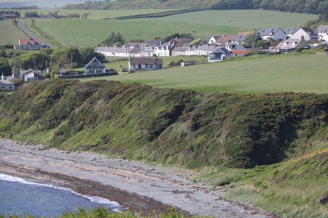
Barsalloch Point is a prominent coastal feature located in Wigtownshire, Scotland. Situated on the western coast, it is known for its stunning headland and picturesque views of the North Channel and the Irish Sea. The point itself juts out into the water, forming a distinct and easily recognizable shape.

The landscape surrounding Barsalloch Point is characterized by rugged cliffs and rocky outcrops, adding to its natural beauty. The headland is primarily composed of sedimentary rocks, such as sandstone and limestone, which have been eroded over time by the relentless forces of the sea. This erosion has resulted in the formation of striking features, such as sea caves and arches.

The point is a popular destination for nature enthusiasts and hikers due to its scenic trails and abundant wildlife. Visitors can explore the coastal paths that meander along the cliff tops, offering breathtaking vistas of the surrounding sea and countryside. The area is teeming with a variety of bird species, including seabirds like gannets and puffins, making it a haven for birdwatchers.

In addition to its natural beauty, Barsalloch Point also holds historical significance. It is believed to have been inhabited by early humans, as evidenced by the presence of ancient artifacts and archaeological remains found in the area. These remnants provide valuable insights into the lives and activities of the people who once lived here.

Overall, Barsalloch Point is a captivating coastal feature that combines stunning natural scenery, diverse wildlife, and a rich historical heritage. Its unique geology and breathtaking views make it a must-visit destination for anyone seeking an authentic and memorable experience in Wigtownshire.

If you have any feedback on the listing, please let us know in the comments section below.

Barsalloch Point Images

Images are sourced within 2km of 54.73721/-4.5696996 or Grid Reference NX3441. Thanks to Geograph Open Source API. All images are credited.

Low tide at Point of Lag Looking south west, across Luce Bay.
Low tide at Point of Lag
Looking south west, across Luce Bay.
Beyond the Point of Lag - Front Bay This spur of land is north of the Point of Lag and west of Front Bay at Monreith and it can only be accessed at low tide for a few hours. Getting here to bag this first took ½ hour to cross 500 yards of slippery rocks and seaweed. It was a truly treacherous journey akin to walking on moving ice. The view from this point is north over Front Bay towards Monreith centre of picture.
Beyond the Point of Lag - Front Bay
This spur of land is north of the Point of Lag and west of Front Bay at Monreith and it can only be accessed at low tide for a few hours. Getting here to bag this first took ½ hour to cross 500 yards of slippery rocks and seaweed. It was a truly treacherous journey akin to walking on moving ice. The view from this point is north over Front Bay towards Monreith centre of picture.
Beyond the Point of Lag - Front Bay This spur of land is north of the Point of Lag and west of Front Bay at Monreith and it can only be accessed at low tide for a few hours. Getting here took ½ hour to cross 500 yards of slippery rocks and seaweed. It was a truly treacherous journey akin to walking on moving ice. The view from this point is east with Front Bay left, Luce Bay right and St Medan Golf Club centre of picture.
Beyond the Point of Lag - Front Bay
This spur of land is north of the Point of Lag and west of Front Bay at Monreith and it can only be accessed at low tide for a few hours. Getting here took ½ hour to cross 500 yards of slippery rocks and seaweed. It was a truly treacherous journey akin to walking on moving ice. The view from this point is east with Front Bay left, Luce Bay right and St Medan Golf Club centre of picture.
Beyond the Point of Lag - Front Bay This spur of land is north of the Point of Lag and west of Front Bay at Monreith and it can only be accessed at low tide for a few hours. Getting here took ½ hour to cross 500 yards of slippery rocks and seaweed. It was a truly treacherous journey akin to walking on moving ice. The view from this point is west towards the end of this spur and across Luce Bay to the Rhins and the Mull of Galloway. Right of picture is Front Bay.
Beyond the Point of Lag - Front Bay
This spur of land is north of the Point of Lag and west of Front Bay at Monreith and it can only be accessed at low tide for a few hours. Getting here took ½ hour to cross 500 yards of slippery rocks and seaweed. It was a truly treacherous journey akin to walking on moving ice. The view from this point is west towards the end of this spur and across Luce Bay to the Rhins and the Mull of Galloway. Right of picture is Front Bay.
Rock and Seaweed This spur of land is north of the Point of Lag and west of Front Bay at Monreith and it can only be accessed at low tide for a few hours. Getting here took ½ hour to cross 500 yards of slippery rocks and seaweed. It was a truly treacherous journey akin to walking on moving ice. The view from this point is to the north west over Luce Bay left and Front Bay towards Barsalloch Point right of picture.
Rock and Seaweed
This spur of land is north of the Point of Lag and west of Front Bay at Monreith and it can only be accessed at low tide for a few hours. Getting here took ½ hour to cross 500 yards of slippery rocks and seaweed. It was a truly treacherous journey akin to walking on moving ice. The view from this point is to the north west over Luce Bay left and Front Bay towards Barsalloch Point right of picture.
Out on a Limb This spur of land is north of the Point of Lag and west of Front Bay at Monreith and it can only be accessed at low tide for a few hours. Getting here took ½ hour to cross 500 yards of slippery rocks and seaweed. It was a truly treacherous journey akin to walking on moving ice. The view from this point is past the Point of Lag towards Back Bay. As I was leaving the tide from Luce Bay right of picture was starting to cover the rocks in front of me towards Front Bay left of picture. Sharp exit stage right before needing the help of the Coast Guard!
Out on a Limb
This spur of land is north of the Point of Lag and west of Front Bay at Monreith and it can only be accessed at low tide for a few hours. Getting here took ½ hour to cross 500 yards of slippery rocks and seaweed. It was a truly treacherous journey akin to walking on moving ice. The view from this point is past the Point of Lag towards Back Bay. As I was leaving the tide from Luce Bay right of picture was starting to cover the rocks in front of me towards Front Bay left of picture. Sharp exit stage right before needing the help of the Coast Guard!
Front Bay This spur of land is north of the Point of Lag and west of Front Bay at Monreith and it can only be accessed at low tide for a few hours. Getting here took ½ hour to cross 500 yards of slippery rocks and seaweed. It was a truly treacherous journey akin to walking on moving ice. The view from this point is over Front Bay towards Monreith.
Front Bay
This spur of land is north of the Point of Lag and west of Front Bay at Monreith and it can only be accessed at low tide for a few hours. Getting here took ½ hour to cross 500 yards of slippery rocks and seaweed. It was a truly treacherous journey akin to walking on moving ice. The view from this point is over Front Bay towards Monreith.
Front Bay This spur of land is north of the Point of Lag and west of Front Bay at Monreith and it can only be accessed at low tide for a few hours. Getting here took ½ hour to cross 500 yards of slippery rocks and seaweed. It was a truly treacherous journey akin to walking on moving ice. The view from this point is over Front Bay towards St Medan Golf Clubhouse centre of picture.
Front Bay
This spur of land is north of the Point of Lag and west of Front Bay at Monreith and it can only be accessed at low tide for a few hours. Getting here took ½ hour to cross 500 yards of slippery rocks and seaweed. It was a truly treacherous journey akin to walking on moving ice. The view from this point is over Front Bay towards St Medan Golf Clubhouse centre of picture.
Front Bay This spur of land is north of the Point of Lag and west of Front Bay at Monreith and it can only be accessed at low tide for a few hours. Getting here took ½ hour to cross 500 yards of slippery rocks and seaweed. It was a truly treacherous journey akin to walking on moving ice. The view from this point is over Front Bay towards Monreith right of picture and Barsalloch Point left. The strip of land ends a couple of yards in front of the camera.
Front Bay
This spur of land is north of the Point of Lag and west of Front Bay at Monreith and it can only be accessed at low tide for a few hours. Getting here took ½ hour to cross 500 yards of slippery rocks and seaweed. It was a truly treacherous journey akin to walking on moving ice. The view from this point is over Front Bay towards Monreith right of picture and Barsalloch Point left. The strip of land ends a couple of yards in front of the camera.
Luce Bay This spur of land is north of the Point of Lag and west of Front Bay at Monreith and it can only be accessed at low tide for a few hours. Getting here took ½ hour to cross 500 yards of slippery rocks and seaweed. It was a truly treacherous journey akin to walking on moving ice. The view from this point is across Luce Bay to the Rhins. This shot was to be my final picture of this blob of land as the tide started to come in and it was time to go.
Luce Bay
This spur of land is north of the Point of Lag and west of Front Bay at Monreith and it can only be accessed at low tide for a few hours. Getting here took ½ hour to cross 500 yards of slippery rocks and seaweed. It was a truly treacherous journey akin to walking on moving ice. The view from this point is across Luce Bay to the Rhins. This shot was to be my final picture of this blob of land as the tide started to come in and it was time to go.
Monreith Bay Looking across St Medan Golf Course.
Monreith Bay
Looking across St Medan Golf Course.
Hedge Trimming Cutting the roadside hedges near South Barsalloch Farm on the North Barsalloch Road from Monreith.
Hedge Trimming
Cutting the roadside hedges near South Barsalloch Farm on the North Barsalloch Road from Monreith.
Barsalloch Fort path Footpath off the A747 near Monreith Bay, leading to Barsalloch Fort .
Barsalloch Fort path
Footpath off the A747 near Monreith Bay, leading to Barsalloch Fort .
Monrieth Sands Holiday Park The entrance to the Monreith Sands Holiday, just off the A747.
Monrieth Sands Holiday Park
The entrance to the Monreith Sands Holiday, just off the A747.
Shore at Monreith Bay Viewed from the Gavin Maxwell Otter Memorial.
Shore at Monreith Bay
Viewed from the Gavin Maxwell Otter Memorial.
Monreith Village Zoomed in from the Gavin Maxwell Otter Memorial.
Monreith Village
Zoomed in from the Gavin Maxwell Otter Memorial.
Field, Monreith
Field, Monreith
A747, Monreith
A747, Monreith
Show me another place!

Barsalloch Point is located at Grid Ref: NX3441 (Lat: 54.73721, Lng: -4.5696996)

Unitary Authority: Dumfries and Galloway

Police Authority: Dumfries and Galloway

What 3 Words

///sway.painter.extremely. Near Whithorn, Dumfries & Galloway

Related Wikis

Monreith

Monreith ([mɒn'ri:θ] / 'mon-REETH'; Scottish Gaelic: Am Monadh Rèidh) is a small seaside village in the Machars, in the historical county of Wigtownshire...

Wren's Egg

The Wren's Egg (grid reference NX 3610 4199) is the name given to a set of late Neolithic or Bronze Age stone monuments in the parish of Glasserton, Wigtownshire...

Monreith House

Monreith House is a category A listed Georgian mansion located 1.5 kilometres (0.93 mi) east of the village of Port William in Mochrum parish in the historical...

Port William, Dumfries and Galloway

Port William (Scottish Gaelic: Cill na Tràghad) is a fishing village in the parish of Mochrum in the historical county of Wigtownshire, Dumfries and Galloway...

Nearby Amenities

Located within 500m of 54.73721,-4.5696996
Source: PGS
Lat/Long: 54.7405696/-4.5724997
Source: PGS
Lat/Long: 54.7402599/-4.5722637
Source: PGS
Lat/Long: 54.7398883/-4.5721349
Source: PGS
Lat/Long: 54.739116/-4.571904
Source: PGS
Lat/Long: 54.73886/-4.571894
Source: PGS
Lat/Long: 54.7381416/-4.5717058
Source: PGS
Lat/Long: 54.7379187/-4.5714054
Source: PGS
Lat/Long: 54.737547/-4.5707831
Source: PGS
Lat/Long: 54.7372002/-4.5700321
Source: PGS
Lat/Long: 54.7370639/-4.5694527
Source: PGS
Lat/Long: 54.7370267/-4.5687232
Source: PGS
Lat/Long: 54.7372249/-4.5679292
Source: PGS
Lat/Long: 54.7373488/-4.5673713
Source: PGS
Lat/Long: 54.7374108/-4.5667276
Source: PGS
Lat/Long: 54.7373488/-4.5659551
Source: PGS
Lat/Long: 54.7372745/-4.5649037
Source: PGS
Lat/Long: 54.7372125/-4.5643673
Source: PGS
Lat/Long: 54.7372125/-4.563466
Source: PGS
Lat/Long: 54.7372249/-4.5625648
Barsallooch Fort
Historic: yes
Lat/Long: 54.7387256/-4.5686896
Information: board
Tourism: information
Lat/Long: 54.7385476/-4.5686265
Information: board
Tourism: information
Lat/Long: 54.7382503/-4.5692703
The data included in this document is from www.openstreetmap.org. The data is made available under ODbL.

Have you been to Barsalloch Point?

Leave your review of Barsalloch Point below (or comments, questions and feedback).