Rubha na Maoil Aird

Landscape Feature in Inverness-shire

Scotland

Rubha na Maoil Aird

Muick The Allt Mhuic nature reserve, situated between two conifer blocks on the north side of Loch Arkaig.
Muick Credit: Richard Webb

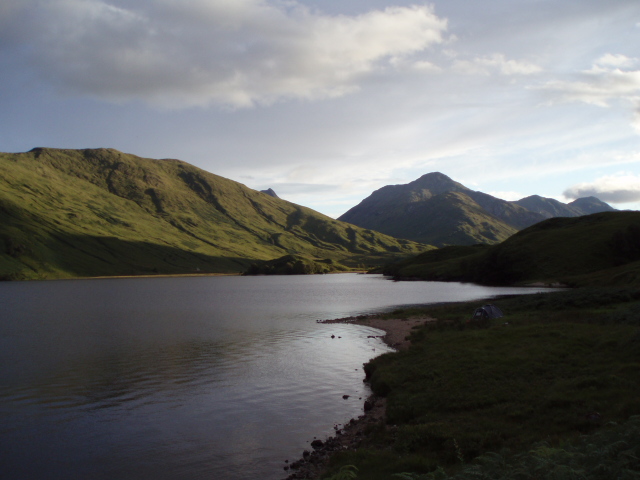
Rubha na Maoil Aird is a stunning landscape feature located in Inverness-shire, Scotland. Situated on the shores of Loch Ness, this rugged headland offers breathtaking views of the surrounding countryside and the iconic lake itself.

The headland is characterized by its rocky cliffs and lush greenery, providing a picturesque backdrop for visitors to enjoy. The area is rich in wildlife, with a variety of bird species making their home in the cliffs and surrounding forests.

Visitors to Rubha na Maoil Aird can take in the beauty of the landscape while exploring the walking trails that wind through the headland. These trails offer opportunities for hikers to immerse themselves in nature and experience the tranquility of the Scottish Highlands.

In addition to its natural beauty, Rubha na Maoil Aird also has historical significance, with archaeological sites dating back to ancient times. These sites provide a glimpse into the area's past and add to the overall allure of the landscape feature.

Overall, Rubha na Maoil Aird is a must-visit destination for nature lovers and history enthusiasts alike, offering a unique blend of beauty and heritage in the heart of Inverness-shire.

If you have any feedback on the listing, please let us know in the comments section below.

Rubha na Maoil Aird Images

Images are sourced within 2km of 56.959498/-5.0741463 or Grid Reference NN1389. Thanks to Geograph Open Source API. All images are credited.

Muick The Allt Mhuic nature reserve, situated between two conifer blocks on the north side of Loch Arkaig.
Muick
The Allt Mhuic nature reserve, situated between two conifer blocks on the north side of Loch Arkaig.
Loch Arkaig road, Muick Passing the Allt Mhuic nature reserve.
Loch Arkaig road, Muick
Passing the Allt Mhuic nature reserve.
Allt a' Mhuic The burn flowing into Loch Arkaig between two numbered caravan plots.
Allt a' Mhuic
The burn flowing into Loch Arkaig between two numbered caravan plots.
Minor road along Loch Arkaig
Dead tree beside Loch Arkaig
Course of Allt Uchdain Mhoir Flows from Beinn Chraoibh to Loch Arkaig
Course of Allt Uchdain Mhoir
Flows from Beinn Chraoibh to Loch Arkaig
Forest on the slopes of Beinn Chraoibh Loch Arkaig
Birch trees above Loch Arkaig
Flanked by silver birch The road along the north shore of Loch Arkaig. It may be tedious to drive (see <a href="https://www.geograph.org.uk/photo/3721761">NN1290 : Bends of road on north side of Loch Arkaig</a>), but it is a delight to cycle or walk.
Flanked by silver birch
The road along the north shore of Loch Arkaig. It may be tedious to drive (see NN1290 : Bends of road on north side of Loch Arkaig), but it is a delight to cycle or walk.
Forest - felled and still standing On the slopes of Beinn Chraoibh above Loch Arkaig.
Forest - felled and still standing
On the slopes of Beinn Chraoibh above Loch Arkaig.
North shore of Loch Arkaig On a perfect autumn's day.
North shore of Loch Arkaig
On a perfect autumn's day.
North shore of Loch Arkaig One theory as to the structure in the foreground is that it is the base for a dismantlable jetty (see <a href="https://www.geograph.org.uk/photo/3733187">NN1390 : North shore of Loch Arkaig</a>).
North shore of Loch Arkaig
One theory as to the structure in the foreground is that it is the base for a dismantlable jetty (see NN1390 : North shore of Loch Arkaig).
View across Loch Arkaig Clouds and mountains reflected in the calm water.
View across Loch Arkaig
Clouds and mountains reflected in the calm water.
Caravan near Ardechive One of several permanently-sited mobile homes along the north shore of Loch Arkaig.
Caravan near Ardechive
One of several permanently-sited mobile homes along the north shore of Loch Arkaig.
North shore of Loch Arkaig Birch trees and gravel shoreline.
North shore of Loch Arkaig
Birch trees and gravel shoreline.
Marker Poles The poles are labelled 'HV Cables' and indicate where it would be unwise to dig holes beside the road.
Marker Poles
The poles are labelled 'HV Cables' and indicate where it would be unwise to dig holes beside the road.
Silver Birches Some of the narrow strip of trees between the road and the shore of Loch Arkaig.
Silver Birches
Some of the narrow strip of trees between the road and the shore of Loch Arkaig.
Show me another place!

Rubha na Maoil Aird is located at Grid Ref: NN1389 (Lat: 56.959498, Lng: -5.0741463)

Unitary Authority: Highland

Police Authority: Highlands and Islands

What 3 Words

///blues.upsetting.mildest. Near Gairlochy, Highland

Nearby Locations

Rubha na Maoil Aird

Related Wikis

Ardechive

Ardechive (Scottish Gaelic: Àird Eachbhaidh) is a small crofting hamlet, located on the shores of Loch Arkaig, close to Achnasaul and Spean Bridge, county...

Achnasaul

Achnasaul (Scottish Gaelic: Achadh nan Sabhal) is a village, located on the shores of Loch Arkaig, close to Spean Bridge, Inverness-shire, Scotland, within...

Loch Arkaig

Loch Arkaig (Scottish Gaelic: Loch Airceig) is a body of freshwater in Lochaber, Scotland, to the west of the Great Glen. It is approximately 12 miles...

Beinn Bhàn (Arkaig)

Beinn Bhàn is a Scottish mountain situated in the Lochaber region of the Highland Council Area. It stands 6 miles (10 km) north-west of Spean Bridge. The...

Have you been to Rubha na Maoil Aird?

Leave your review of Rubha na Maoil Aird below (or comments, questions and feedback).