Broadsole Pond

Lake, Pool, Pond, Freshwater Marsh in Kent Dover

England

Broadsole Pond

Chalk cliffs
Chalk cliffs Credit: N Chadwick

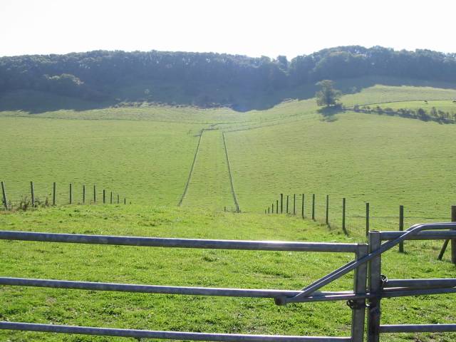
Broadsole Pond is a picturesque freshwater body located in Kent, England. Covering an area of approximately 4 hectares, it is often referred to as a lake, pool, pond, or freshwater marsh due to its varying characteristics and diverse ecosystem. The pond is situated within the larger Broadsole Nature Reserve, which spans over 25 hectares.

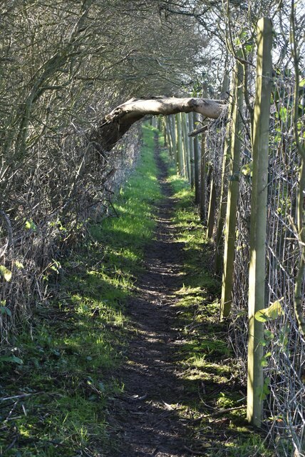
Surrounded by lush vegetation, including reeds and water lilies, Broadsole Pond provides a tranquil habitat for numerous plant and animal species. The pond's water is predominantly sourced from rainfall, groundwater, and natural springs, resulting in a consistently high water quality.

The diverse flora and fauna found in and around Broadsole Pond contribute to its ecological importance. The pond is home to various species of fish, such as carp and pike, which thrive in the nutrient-rich water. Additionally, it serves as a vital breeding ground for amphibians such as frogs and newts.

The surrounding wetland vegetation provides an important habitat for a variety of bird species, including mallards, coots, and herons. These birds can often be spotted feeding on the pond's abundant insect population or nesting in the nearby trees and reeds.

Broadsole Pond is a popular destination for nature enthusiasts and those seeking a peaceful retreat. Visitors can enjoy the tranquility of the surroundings and observe the diverse wildlife that thrives in this unique freshwater ecosystem. The pond also offers opportunities for fishing and serves as an important educational resource, allowing visitors to learn about the importance of wetland conservation and the rich biodiversity that exists within the area.

If you have any feedback on the listing, please let us know in the comments section below.

Broadsole Pond Images

Images are sourced within 2km of 51.116358/1.2334264 or Grid Reference TR2640. Thanks to Geograph Open Source API. All images are credited.

Chalk cliffs
Chalk cliffs
Dover Transmitting Station The Dover transmitting station is a facility for broadcasting and telecommunications, located at West Hougham, near Dover. It has a 243.2 metres (798 ft) high guyed steel lattice mast.
Wikipedia: <span class="nowrap"><a title="https://en.wikipedia.org/wiki/Dover_transmitting_station" rel="nofollow ugc noopener" href="https://en.wikipedia.org/wiki/Dover_transmitting_station">Link</a><img style="margin-left:2px;" alt="External link" title="External link - shift click to open in new window" src="https://s1.geograph.org.uk/img/external.png" width="10" height="10"/></span>
Dover Transmitting Station
The Dover transmitting station is a facility for broadcasting and telecommunications, located at West Hougham, near Dover. It has a 243.2 metres (798 ft) high guyed steel lattice mast. Wikipedia: LinkExternal link
Victorian postbox In the British Isles the first pillar post boxes were erected in Jersey in 1852. Roadside wall boxes first appeared in 1857 as a cheaper alternative to pillar boxes, especially in rural districts. In 1853 the first pillar box in Britain was installed at Botchergate, Carlisle. In 1856 Richard Redgrave of the Department of Science and Art designed an ornate pillar box for use in London and other large cities. In 1859 the design was improved, and this became the first National Standard pillar box. Green was adopted as the standard colour for the early Victorian post boxes. Between 1866 and 1879 the hexagonal Penfold post box became the standard design for pillar boxes and it was during this period that red was first adopted as the standard colour. The first boxes to be painted red were in London in July 1874, although it would be nearly 10 years before all the boxes had been repainted.
Victorian postbox
In the British Isles the first pillar post boxes were erected in Jersey in 1852. Roadside wall boxes first appeared in 1857 as a cheaper alternative to pillar boxes, especially in rural districts. In 1853 the first pillar box in Britain was installed at Botchergate, Carlisle. In 1856 Richard Redgrave of the Department of Science and Art designed an ornate pillar box for use in London and other large cities. In 1859 the design was improved, and this became the first National Standard pillar box. Green was adopted as the standard colour for the early Victorian post boxes. Between 1866 and 1879 the hexagonal Penfold post box became the standard design for pillar boxes and it was during this period that red was first adopted as the standard colour. The first boxes to be painted red were in London in July 1874, although it would be nearly 10 years before all the boxes had been repainted.
Church Farmhouse
Church Farmhouse
War Memorial, Church of St Lawrence Grade II listed.
War Memorial, Church of St Lawrence
Grade II listed.
Church of St Lawrence and war memorial Grade I listed. <span class="nowrap"><a title="https://historicengland.org.uk/listing/the-list/list-entry/1070024" rel="nofollow ugc noopener" href="https://historicengland.org.uk/listing/the-list/list-entry/1070024">Link</a><img style="margin-left:2px;" alt="External link" title="External link - shift click to open in new window" src="https://s1.geograph.org.uk/img/external.png" width="10" height="10"/></span> 
<span class="nowrap"><a title="https://www.kentchurches.info/church.asp?p=Hougham" rel="nofollow ugc noopener" href="https://www.kentchurches.info/church.asp?p=Hougham">Link</a><img style="margin-left:2px;" alt="External link" title="External link - shift click to open in new window" src="https://s1.geograph.org.uk/img/external.png" width="10" height="10"/></span>
Church of St Lawrence and war memorial
Grade I listed. LinkExternal link LinkExternal link
Church of St Lawrence Grade I listed. <span class="nowrap"><a title="https://historicengland.org.uk/listing/the-list/list-entry/1070024" rel="nofollow ugc noopener" href="https://historicengland.org.uk/listing/the-list/list-entry/1070024">Link</a><img style="margin-left:2px;" alt="External link" title="External link - shift click to open in new window" src="https://s1.geograph.org.uk/img/external.png" width="10" height="10"/></span> 
<span class="nowrap"><a title="https://www.kentchurches.info/church.asp?p=Hougham" rel="nofollow ugc noopener" href="https://www.kentchurches.info/church.asp?p=Hougham">Link</a><img style="margin-left:2px;" alt="External link" title="External link - shift click to open in new window" src="https://s1.geograph.org.uk/img/external.png" width="10" height="10"/></span>
Church of St Lawrence
Grade I listed. LinkExternal link LinkExternal link
Church of St Lawrence Grade I listed buildings and structures are of exceptional, even international importance. There are over 6,000 in the country. Only 2.5% of listed buildings are Grade I listed.
In Scotland the classification is Category A
Index: <span class="nowrap"><a title="http://en.wikipedia.org/wiki/Category:Grade_I_listed_buildings" rel="nofollow ugc noopener" href="http://en.wikipedia.org/wiki/Category:Grade_I_listed_buildings">Link</a><img style="margin-left:2px;" alt="External link" title="External link - shift click to open in new window" src="https://s1.geograph.org.uk/img/external.png" width="10" height="10"/></span>
Church of St Lawrence
Grade I listed buildings and structures are of exceptional, even international importance. There are over 6,000 in the country. Only 2.5% of listed buildings are Grade I listed. In Scotland the classification is Category A Index: LinkExternal link
Dover Transmitting Station The Dover transmitting station is a facility for broadcasting and telecommunications, located at West Hougham, near Dover. It has a 243.2 metres (798 ft) high guyed steel lattice mast.
Wikipedia: <span class="nowrap"><a title="https://en.wikipedia.org/wiki/Dover_transmitting_station" rel="nofollow ugc noopener" href="https://en.wikipedia.org/wiki/Dover_transmitting_station">Link</a><img style="margin-left:2px;" alt="External link" title="External link - shift click to open in new window" src="https://s1.geograph.org.uk/img/external.png" width="10" height="10"/></span>
Dover Transmitting Station
The Dover transmitting station is a facility for broadcasting and telecommunications, located at West Hougham, near Dover. It has a 243.2 metres (798 ft) high guyed steel lattice mast. Wikipedia: LinkExternal link
Church of St Lawrence Grade I listed. <span class="nowrap"><a title="https://historicengland.org.uk/listing/the-list/list-entry/1070024" rel="nofollow ugc noopener" href="https://historicengland.org.uk/listing/the-list/list-entry/1070024">Link</a><img style="margin-left:2px;" alt="External link" title="External link - shift click to open in new window" src="https://s1.geograph.org.uk/img/external.png" width="10" height="10"/></span> 
<span class="nowrap"><a title="https://www.kentchurches.info/church.asp?p=Hougham" rel="nofollow ugc noopener" href="https://www.kentchurches.info/church.asp?p=Hougham">Link</a><img style="margin-left:2px;" alt="External link" title="External link - shift click to open in new window" src="https://s1.geograph.org.uk/img/external.png" width="10" height="10"/></span>
Church of St Lawrence
Grade I listed. LinkExternal link LinkExternal link
Narrow, enclosed footpath
Dover Transmitting Station The Dover transmitting station is a facility for broadcasting and telecommunications, located at West Hougham, near Dover. It has a 243.2 metres (798 ft) high guyed steel lattice mast.
Wikipedia: <span class="nowrap"><a title="https://en.wikipedia.org/wiki/Dover_transmitting_station" rel="nofollow ugc noopener" href="https://en.wikipedia.org/wiki/Dover_transmitting_station">Link</a><img style="margin-left:2px;" alt="External link" title="External link - shift click to open in new window" src="https://s1.geograph.org.uk/img/external.png" width="10" height="10"/></span>
Dover Transmitting Station
The Dover transmitting station is a facility for broadcasting and telecommunications, located at West Hougham, near Dover. It has a 243.2 metres (798 ft) high guyed steel lattice mast. Wikipedia: LinkExternal link
Show me another place!

Broadsole Pond is located at Grid Ref: TR2640 (Lat: 51.116358, Lng: 1.2334264)

Administrative County: Kent

District: Dover

Police Authority: Kent

What 3 Words

///serenade.pampering.incomes. Near Capel le Ferne, Kent

Related Wikis

St Mary's Church, Capel-le-Ferne

St Mary's Church is a redundant Anglican church to the northeast of the village of Capel-le-Ferne, Kent, England. It is recorded in the National Heritage...

Hougham Without

Hougham Without is a civil parish between Dover and Folkestone in southeast England. The main settlements are the villages of Church Hougham and West Hougham...

Dover transmitting station

The Dover transmitting station is a facility for broadcasting and telecommunications, located at West Hougham, near Dover, Kent (grid reference TR274397...

RNAS Capel

RNAS Capel (later RAF Folkestone) was a First World War airship station near Folkestone, Kent. == History == When Germany declared in February 1915 that...

Folkestone Warren

Folkestone Warren is a 316.3-hectare (782-acre) biological and geological Site of Special Scientific Interest (SSSI) which runs along the coast between...

East Cliff and Warren Country Park

East Cliff and Warren Country Park is in Folkestone, in Kent, England. This country park is formed of the East Cliffs of Folkestone, the sandy beaches...

St. Radegund's Abbey

St. Radegund's Abbey at Bradsole was a medieval monastic house in the parish of Hougham Without near Dover in southeast England. It was dedicated to Radegund...

Alkham Valley

The Alkham Valley is in the Kent Downs (the eastern part of the North Downs), an Area of Outstanding Natural Beauty, in South East Kent, England. The valley...

Nearby Amenities

Located within 500m of 51.116358,1.2334264
West Hougham
Place: hamlet
Population: 650
Wikidata: Q76835942
Lat/Long: 51.116099/1.2354807
Turning Circle
Lat/Long: 51.1169129/1.2355682
Barrier: stile
Lat/Long: 51.1152704/1.239975
Barrier: stile
Lat/Long: 51.1166373/1.2388815
Barrier: stile
Lat/Long: 51.1187808/1.2335618
Barrier: stile
Lat/Long: 51.1173965/1.2357334
Barrier: stile
Lat/Long: 51.1180117/1.2336184
Barrier: stile
Lat/Long: 51.1171807/1.2334535
Barrier: stile
Lat/Long: 51.1166468/1.2334764
Barrier: stile
Lat/Long: 51.1171023/1.2333507
Bus Stop
Post Office
Flag: no
Naptan AtcoCode: 2400A043500A
Naptan Bearing: NE
Naptan BusStopType: CUS
Naptan CommonName: Post Office
Naptan Indicator: NE-bound
Naptan Landmark: The Chequers
Naptan NaptanCode: kntdtpmg
Naptan Street: The Street
Naptan Verified: no
Public Transport: platform
Source: naptan_import
Lat/Long: 51.1162924/1.2361777
Bus Stop
Post Office
Flag: no
Naptan AtcoCode: 2400A043510A
Naptan Bearing: SW
Naptan BusStopType: CUS
Naptan CommonName: Post Office
Naptan Indicator: SW-bound
Naptan Landmark: The Chequers
Naptan NaptanCode: kntdtpmj
Naptan Street: The Street
Naptan Verified: no
Public Transport: platform
Source: naptan_import
Lat/Long: 51.1163395/1.236424
Post Box
Brand: Royal Mail
Brand Wikidata: Q638098
Collection Times: Mo-Fr 16:00; Sa 11:00
Operator: Royal Mail
Operator Wikidata: Q638098
Post Box Mounting: metal_post
Post Box Type: lamp
Ref: CT15 119
Royal Cypher: EIIR
Royal Cypher Wikidata: Q33102113
Lat/Long: 51.1164574/1.2364612
Generator Method: photovoltaic
Generator Output Electricity: yes
Generator Source: solar
Generator Type: solar_photovoltaic_panel
Location: roof
Power: generator
Lat/Long: 51.116502/1.2371233
Generator Method: photovoltaic
Generator Output Electricity: yes
Generator Source: solar
Generator Type: solar_photovoltaic_panel
Location: roof
Power: generator
Lat/Long: 51.116379/1.2359968
Generator Method: photovoltaic
Generator Output Electricity: yes
Generator Source: solar
Generator Type: solar_photovoltaic_panel
Location: roof
Power: generator
Lat/Long: 51.1142895/1.2345591
Generator Method: photovoltaic
Generator Output Electricity: yes
Generator Source: solar
Generator Type: solar_photovoltaic_panel
Location: roof
Power: generator
Lat/Long: 51.1144427/1.2350124
Generator Method: photovoltaic
Generator Output Electricity: yes
Generator Source: solar
Generator Type: solar_photovoltaic_panel
Location: roof
Power: generator
Lat/Long: 51.116528/1.2347643
Power: pole
Switch: yes
Lat/Long: 51.1196503/1.2319507
Power: pole
Lat/Long: 51.1203325/1.2316839
Power: pole
Transformer: distribution
Lat/Long: 51.1182388/1.2394737
The data included in this document is from www.openstreetmap.org. The data is made available under ODbL.

Have you been to Broadsole Pond?

Leave your review of Broadsole Pond below (or comments, questions and feedback).